SoldJ. & W. Blaeu mapJ. & W. Blaeu- ''Suffolcia, Vernacale Suffolk''- hand-colored engraved map, 1692 or later, Amsterdam, with coat of arms on ribbons and a decorative title cartouche, fold down center as should be, someSee Sold Price
SoldMAP OF ANGLIA REGNUM ENGLAND & WALES 1635Reproduction of W. & J. Blaeu's map of Anglia Regnum: England and Wales circa 1635 whence under the rule of that tyrant authoritarian King Charles I--enemy of Parliament and perpetrator of the War ofSee Sold Price
Sold(MAP) BLAEU, W. & J. A group of 2 hand-colored engr(MAP) BLAEU, W. & J. A group of two hand-colored engraved maps of Milan. [Amsterdam, c. 1640 or later] Ducato ouero territoria di Milano and Stato di Milano. Framed and matted, pasted down. 16See Sold Price
Sold(MAP) BLAEU, W. & J. Ducatus Uplandia. [Amsterdam,(MAP) BLAEU, W. & J. Ducatus Uplandia. [Amsterdam, c. 1645 or later] Hand-colored engraved map of the area around this southern coastal region of Sweden near Stockholm. With two armorial vignettes, inSee Sold Price
Sold(MAP) BLAEU, W. & J. Comitatus Northantonenis... [A(MAP) BLAEU, W. & J. Comitatus Northantonensis. Vernacule Northamtonshire. [Amsterdam, c. 1645 or later] Hand-colored engraved map, with 13 armorial shields and illustrated vignette to lower right corSee Sold Price
Sold(MAP) BLAEU, W. & J.Virginiae partis australis... [(MAP) BLAEU, W. & J. Virginiae partis australis, et Floridae partis orientalis, interjacentiumq, regionum Nova Descriptio. [Amsterdam, c. 1640 or later] Hand-colored engraved map of the east coast. FrSee Sold Price
Blaeu (J & W) 4 county mapsBlaeu (Johan & Willem) Glocestria Ducatus; Wiltonia sive Comitatus Wiltoniensis; Herefordia Comitatus; Monumethensis Comitatus,4 county maps of Gloucestershire, Wiltshire, Herefordshire and MoSee Sold Price
Blaeu (J & W) 3 county mapsBlaeu (Johan & Willem) Wigorniensis; Comitatus Nottinghamiensis; Lincolnia Comitatus,3 county maps of Warwickshire, Nottinghamshire and Lincolnshire, all with decorative title cartouches and cSee Sold Price
Blaeu (J & W) Guinea[Blaeu (J & W)] Guinea, engraved map of the coast of Guinea, the interior with elephants, lions, and monkeys, numerous ships, decorative cartouche, with full original hand-colouring, 425 x 535See Sold Price
SoldLeicestershire county map, ca. 1645J. & W. Blaeu- ''Leicestrenis Comitatus/ Leicester Shire''- hand-colored engraving, Amsterdam, decorated with ducal arms, cherubs surround the mileage key. 16 x 19 1/2'See Sold Price
SoldJ. & W. map, 17th c,J. & W. Blaeu- ''Herefordia Comitatus- Herfordshire''- hand-colored engraving, 1664, Amsterdam, decorative cartouche, humerous coat-of-arms,laid down, some staining and foxing. 16 x 19 3/4''hSee Sold Price
Belgian regional area around Mechelen 1635-1660, by J.Title: Belgian regional area around Mechelen 1635-1660, by J. W. Blaeu. Date/Period: 1635-1660 Materials: Copperplate engravedSize: 17 1/2 x 22 “ Belgian regional map centers on the cities of MechelSee Sold Price
Northern France 1647Map Title: Picardia Regio Belgica Published: Blaeu, W. & J., Amsterdam Date: 1647 Size: 15 x 21 inches Richly colored map of Picardy in Northern France along the Somme River, with a Charming CartoucheSee Sold Price
Sold[Blaeu (J & W] Descriptio Corsicae Insulae[Blaeu (J & W] Descriptio Corsicae Insulaeengraved map with light hand-colouring, 345 x 230mm., [Amsterdam], [c.1640] Jansson (Johannes) Languedoc, the south of France from Limosin to ProvenSee Sold Price
SoldBlaeu (J & W) Turcicum ImperiumBlaeu (J & W) Turcicum Imperium, engraved map of Asia, showing part of Europe, Turkey, Egypt, and Arabia, with decorative cartouche, and hand-colouring, 415 x 520mm., Dutch text on verso, someSee Sold Price
Sold[Blaeu (J & W)] Comitatus NorthantonensisNorthamptonshire.- [Blaeu (J & W)] Comitatus Northantonensis, engraved map of Northamptonshire, pictorial cartouche, coats-of-arms, with hand-colouring, 415 x 495mm., French text on verso, teaSee Sold Price
SoldW J BLAEUWest Africa Guinea C1635 Engraving OriginalDetails: BLAEU, W. & J. [West Africa] Guinea. Amsterdam: Blaeu, c. 1635. Engraved with original outline color. Sheet size: 21 5/ 8 x 25 1/2". Early state.This early version of Blaeu's map of the AfriSee Sold Price
Sold[Blaeu (J & W)] Fifae Pars Orientalis[Blaeu (J & W)] Fifae Pars Orientalis, engraved map of Fife and the Firth of Forth, with decorative cartouche, and hand-colouring, 420 x 530mm., French text on verso, window mounted, [AmsterdaSee Sold Price
[Blaeu (J & W)] Candia olim Creta[Blaeu (J & W)] Candia olim Creta, engraved map of Crete, ornamental cartouche and ships, with hand-colouring, 385 x 530mm., Dutch text on verso, small rust mark, [Amsterdam], [c.1650]See Sold Price
Sold[Blaeu (J & W)] CumbriaCumbria.- [Blaeu (J & W)] Cumbria; vulgo Cumberland, engraved map of Cumbria, large pictorial cartouche, coats-of-arms, and ships, with original hand-colouring, 415 x 500mm., French text on veSee Sold Price
Sold[Blaeu (J & W)] Cantium vernacule KentKent.- [Blaeu (J & W)] Cantium vernacule Kent, engraved map of Kent, decorative cartouche and coats-of-arms, with hand-colouring, 390 x 535mm., Dutch text on verso, tear to edge of plate, withSee Sold Price
Sold[Blaeu (J & W)] Bercheria vernacule BarkshireBerkshire.- [Blaeu (J & W)] Bercheria vernacule Barkshire, engraved map of Berkshire, large decorative cartouche, with original hand-colouring, 385 x 500mm., French text on verso, some dust soSee Sold Price
SoldBlaeu (J & W) Persia sive Sophorum RegnumBlaeu (J & W) Persia sive Sophorum Regnumengraved map with original hand-colouring, 380 x 490mm., Latin text verso, splitting on central vertical fold, some cracking along lines of pigment, wiSee Sold Price
[Blaeu (J & W)] Nova Aegypti TabulaEgypt.- [Blaeu (J & W)] Nova Aegypti Tabula, engraved map of Egypt, decorative cartouche, with full original hand-colouring, 440 x 525mm., Latin text on verso, some discolouration, repair to vSee Sold Price
Pair of Early Railroad Maps - 1874 Delaware, Lackawanna & Western and 1876 Pennsylvania RailroadRail & Road Auctions4.6(165)See Sold PriceMar 07, 2024
Willem Blaeu, Etc. 17th C. Antiquarian Maps, 2Auctions at Showplace4.6(731)See Sold PriceMar 17, 2024
1736 LARGE MAP OF SILESIA POLAND OPPAVIENSIS antique 25 by 34 3/4"Jasper524.5(9.8k)See Sold PriceFeb 27, 2024
1675 ELZEVIER JULIUS CAESAR antique ILLUSTRATED w/ MAPS ROMAN HISTORYJasper524.5(9.8k)See Sold PriceFeb 27, 2024
1736 LARGE MAP OF SILESIA POLAND KARNOVIENSIS antique 25 x 4 3/4" Duchy of KrnovJasper524.5(9.8k)See Sold PriceFeb 27, 2024
Birmingham.- Commercial map.- Smith (J. Pigott) To the Right Honourable William Earl of Dartmouth...Forum Auctions4.3(53)See Sold PriceFeb 29, 2024
Tour of the Dutch East Indies, with exceptional platesPBA Galleries4.7(383)See Sold PriceMar 07, 2024
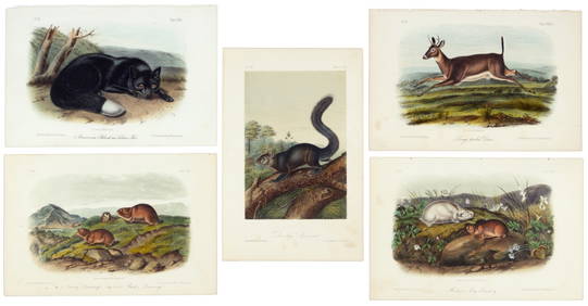
First 50 plates from Audubon's Quad Quarto (all in Vol. I)PBA Galleries4.7(383)See Sold PriceMar 07, 2024
Nearly complete set of plates from Vol. III Quad QuartoPBA Galleries4.7(383)See Sold PriceMar 07, 2024
Clarke & Neele 1815 Map. Europe - Recent Political ChangesAlbion Auctions4.6(341)See Sold PriceMar 01, 2024
Antique Map - Views on the coast of Asia. J. Webber del. Engraved after J. Webber and W. Bligh.Proverde Auctions4.3(3)See Sold PriceFeb 28, 2024


![[Blaeu (J & W] Descriptio Corsicae Insulae (1 of 1)](https://p1.liveauctioneers.com/410/8611/1592276_1_x.jpg?height=282&quality=70)

![[Blaeu (J & W)] Comitatus Northantonensis (1 of 1)](https://p1.liveauctioneers.com/410/3027/1300484_1_x.jpg?height=282&quality=70)

![[Blaeu (J & W)] Fifae Pars Orientalis (1 of 1)](https://p1.liveauctioneers.com/410/3027/1300492_1_x.jpg?height=282&quality=70)
![[Blaeu (J & W)] Candia olim Creta (1 of 1)](https://p1.liveauctioneers.com/410/3027/1300237_1_x.jpg?height=282&quality=70)
![[Blaeu (J & W)] Cumbria (1 of 1)](https://p1.liveauctioneers.com/410/3027/1300413_1_x.jpg?height=282&quality=70)
![[Blaeu (J & W)] Cantium vernacule Kent (1 of 1)](https://p1.liveauctioneers.com/410/3027/1300451_1_x.jpg?height=282&quality=70)
![[Blaeu (J & W)] Bercheria vernacule Barkshire (1 of 1)](https://p1.liveauctioneers.com/410/3027/1300394_1_x.jpg?height=282&quality=70)


![[Blaeu (J & W)] Nova Aegypti Tabula (1 of 1)](https://p1.liveauctioneers.com/410/3027/1300201_1_x.jpg?height=282&quality=70)