Sold(MAP) BLAEU, W. & J. A group of 2 hand-colored engr(MAP) BLAEU, W. & J. A group of two hand-colored engraved maps of Milan. [Amsterdam, c. 1640 or later] Ducato ouero territoria di Milano and Stato di Milano. Framed and matted, pasted down. 16See Sold Price
Sold(MAP, SCOTLAND) BLEAU, J. A group of 2 hand-colore(MAP, SCOTLAND) BLEAU, J. A group of two hand-colored copper engraved maps of British Isles. (Amsterdam: J. Blaeu, 1654). Each with richly hand-colored borders, forests, mountain ranges and towns, decSee Sold Price
SoldLeicestershire county map, ca. 1645J. & W. Blaeu- ''Leicestrenis Comitatus/ Leicester Shire''- hand-colored engraving, Amsterdam, decorated with ducal arms, cherubs surround the mileage key. 16 x 19 1/2'See Sold Price
SoldJ. & W. Blaeu mapJ. & W. Blaeu- ''Suffolcia, Vernacale Suffolk''- hand-colored engraved map, 1692 or later, Amsterdam, with coat of arms on ribbons and a decorative title cartouche, fold down center as should be, someSee Sold Price
Sold1 piece. Hand-Colored Engraved Map. Blaeu, Willia1 piece. Hand-Colored Engraved Map. Blaeu, William J. Magni Ducatus Lithuaniae." Amsterdam, 1613. 30 x 29 1/2 inches (762 x 749 mm), narrow margins. Mounted to bd., upper left corner chipped, affectinSee Sold Price
Sold18th C. Blaeu Maps18th century hand colored maps including, "View of Venezuela" and "Mar Del Norte", each 15" h x 19 1/2" w (view), 22" h x 27" w (frame). Provenance: CA estate.See Sold Price
SoldTwo engraved and hand-colored maps of Egypt1) J. Jansson; "Aegypti Recentior Descriptio …" (Amsterdam: 1666) about 16 X 20 in., p.m.; 2) J. Blaeu, "Nova Aegypti Tabula" circa 1670, about 17 1/4 X 20 1/2 in., p.m.; Property from the Hans GoedSee Sold Price
SoldScenes of Europe engravings, 19th c.Group of 4 hand colored steel engravings of scenes of Europe. 19th c. ++ J. C. Varrall after W. J. Cooke. 'Amsterdam van het IJ gezien.' (Amsterdam, The Netherlands, view from the IJ-lake). From "HetSee Sold Price
SoldEnglish School (19th Century), Group of Four Rabbitinghand-colored prints mounted to panel, one signed "ColD J. W. Sr.," housed in uniform gilt frames. DOA 7 1/4 x 9 1/2 in. This suite once hung in the main salon of the "Maggie Fury," an auxiliary yawl dSee Sold Price
7 Engraved and Hand-Colored MapsLot of seven maps, engraved and hand-colored, by S. Augustus Mitchell, Pierre Jean Bonpare, William and Joan Blaeu, etc., two unframed, circa 17th, 18th and 19th centuries, 14 3/4"h x 19 1/2"w (view),See Sold Price
1859 Texas Map by ColtonTitle: 1859 Texas Map by Colton Date/Period: 1859 Materials: Hand colored steering engraved Size: 17 1/2 x 14 1/2” This map, created by J. H. Colton & G. W. Colton, depicts Texas before the CiviSee Sold Price
Sold3 18th C. maps incl. R. Vaugondy and J. BaylyItem 1: Robert de Vaugondy hand colored map "Amerique septen trionale." French, 1750. 6 3/8" H x 6 1/2" W. Item 2: Robert de Vaugondy hand colored map "Mappe Monde" French, 1750. 6 3/8" H x 12 1/8" W.See Sold Price
SoldThree Maps of A. J. Johnson's , "Venetia, Kingdom ofThree Maps of A. J. Johnson's , "Venetia, Kingdom of Italy," 1863, hand colored, H.- 26 1/2 in., W.- 18 in. Italy, 1863 (3 Pcs.)See Sold Price
SoldTwo Maps by A. J. Johnson, "Africa," 1864, handTwo Maps by A. J. Johnson, "Africa," 1864, hand colored, H.- 26 1/2 in., W.- 18 in. (2 Pcs.)See Sold Price
Sold1855 Map of Georgetown and the City of Washington by J.H. ColtonColton's Georgetown and the city of Washington: the capital of the United States of America. Issued in 1855 by J. H. Colton (1800-1893). Hand colored. Frame size: 20 1/2" H x 24 3/4" W x 1 1/8" D. SigSee Sold Price
SoldGroup of Early 19th Century Celestial Mapshand-colored engravings by W. G. Evans of New York, under the direction of editor E. H. Burritt. published 1835, Hartford, Connecticut by F. J. Huntington in the “Atlas of the Heavens”. the atlasSee Sold Price
Sold2 Antique MapsOne hand-colored engraving Hambourg? J. Covens & C. Mortier, approx. 18" H x 22" W sight, 24" H x 27" W framed. One hand-colored engraving, "Nova Anglia." Johann B. Homann, approx. 21" H x 25" W sightSee Sold Price
SoldFRENCH INTERIOR PRINTS + ONE OF CHATEAUFRENCH, HAND COLORED INTERIOR PRINTS + ONE OF CHATEAU, GROUP OF 4, C 1930 H 4 3/4" X W 3 1/2":Matted and framed. Having 3 signed lower right. Ex estate Frank J Sladen, Grosse Pointe FarmsSee Sold Price
SoldATTRIBUTED TO WILLEN BLAEU 2 ENGRAVED MAPSATTRIBUTED TO WILLEN BLAEU, 2 HAND COLORED ENGRAVED MAPS, "NAVA BELGICA" & "MAPPA AESTIVARUM", 15 1/4" X 19 3/4" & 16" X 21" DATES OF PRINTING ARE UNKNOWN; FRAMED. ARNOLD KLEIN FRAMING LABEL.See Sold Price
SoldFramed large antique map of Ireland by W. Blaeu.Framed large antique map of Ireland by W. Blaeu. Hand-colored copper plate engraving. Published in Amersterdam, 1635. Measures 16.5" w x 20.5". Originally purchased at Jonathan Potter, LTD., London. BSee Sold Price
SoldA Pair of Humorous Horse ScenesA Pair of Humorous Horse Scenes , "Deacon Jones' One Hoss Shay, No. 1", and "Deacon Jones' One Hoss Shay, No. 2", hand-colored lithographs by W. J. Warner, 1879, published by F.M. Haskell & Co., BostoSee Sold Price
SoldAtlas of 17th Century Antique Maps - 45Hand made atlas consisting of 45 17th Century European maps. All hand drawn and hand colored. Maps by Blaeuw, Hondius, Homann et al. One map carries a date of 1610. All maps laid on paper. Book 16.5"See Sold Price
SoldHand Colored and Engraved Map - Portugallia et AlgarbiaBLAEU, W. Hand colored, engraved and printed map. Portugallia et Algarbia quae olim Lusitania. After the original prepared by Fernando Alvarez Secco, a Portuguese map maker who's map was used by varioSee Sold Price
SoldW. Blaeu, hand-colored copper engraved map, c. 16W. Blaeu, "Nova Italiae Delineatio" , hand-colored copper engraved map, c. 1664, Amsterdam, from "Atlas Major", embellished with decorative cartouche and scale, ships and sea monster, sight 15 in. x 1See Sold Price
MARTINET / DE VRIES Catechism of Nature 4 Vol. Set c1788 Engravings Rare!Luis Porretta Fine Arts4.3(10)See Sold PriceMar 02, 2024
BOTH TITLE PAGES OF COLLINS" COASTAL SURVEY, 1776, IN MATCHING FRAMESThomaston Place Auction Galleries4.4(393)See Sold PriceFeb 24, 2024
ABRAHAM ORTELIUS (1527-1598) MAP OF ROMAN GAUL (FRANCE)Thomaston Place Auction Galleries4.4(393)See Sold PriceFeb 24, 2024
Willem Blaeu, Etc. 17th C. Antiquarian Maps, 2Auctions at Showplace4.6(740)See Sold PriceMar 17, 2024
Albin - Bald or Vulturine Eagle. 2-3Trillium Antique Prints & Rare Books4.5(32)See Sold PriceFeb 24, 2024
Albin - King Vulture or Warwounen. 2-4Trillium Antique Prints & Rare Books4.5(32)See Sold PriceFeb 24, 2024
THREE HAND COLORED AND ADORNED PRINTS.Amelia Jeffers, Auctioneers & Appraisers4.5(120)See Sold PriceMar 08, 2024
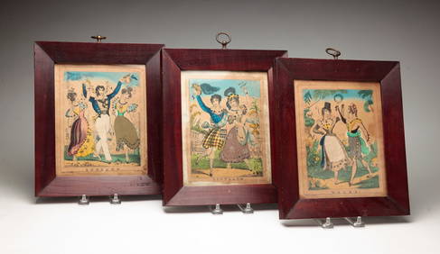
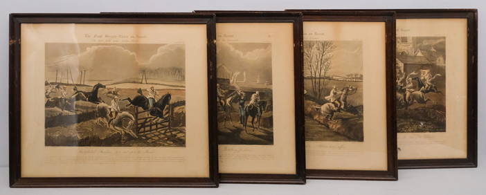
After H. Alken, Group of 4 Steeplechase PrintsOld Kinderhook Auction Company4.6(217)See Sold PriceMar 05, 2024
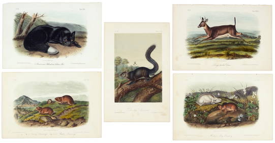
First 50 plates from Audubon's Quad Quarto (all in Vol. I)PBA Galleries4.7(385)See Sold PriceMar 07, 2024
Nearly complete set of plates from Vol. III Quad QuartoPBA Galleries4.7(385)See Sold PriceMar 07, 2024
Two Hand-Colored 19th Century Maps of New Orleans and Louisiana, Larger- H.- 12 1/2 in., W.- 15 1/2Crescent City Auction Gallery4.3(231)See Sold PriceMar 08, 2024
1849 Orr & Co. Hand Colored Southern Germany MapMatthew Bullock Auctioneers4.7(1.8k)See Sold PriceMar 02, 2024