ATLAS of ANTIENT GEOGRAPHY by SAMUEL BUTLER 1843John McInnis Auctioneers,LLC4.6(504)See Sold PriceFeb 24, 2024
18TH C. ANTIQUE MAP: FRENCH & INDIAN WAR, FRAMEDThomaston Place Auction Galleries4.4(389)See Sold PriceFeb 24, 2024
Rand McNally Railroad Map Cabinet w/ 21 Railroad MapsRail & Road Auctions4.6(165)See Sold PriceMar 08, 2024
Keith Haring - Ink on New York Map, Best Buddies, Inscribed, Signed, and DatedSapphire Auction Gallery4.1(67)See Sold PriceMar 02, 2024
LATE 17TH C. FRENCH MAP OF THE NEW WORLD BY ALEXIS-HUBERT JAILLOT (1632-1712)Thomaston Place Auction Galleries4.4(389)See Sold PriceFeb 24, 2024
Central Railroad of New Jersey Map of Sandy Hook Route-ca. 1903JM Hobby Supply and Railroad Artifact Auctions4.4(126)See Sold PriceFeb 24, 2024
Lot of Six Mixed Atlas Box Cars-HO Scale-New in BoxJM Hobby Supply and Railroad Artifact Auctions4.4(126)See Sold PriceFeb 25, 2024
Rand McNally/Santa Fe Railroad Map of Iowa-1912JM Hobby Supply and Railroad Artifact Auctions4.4(126)See Sold PriceFeb 24, 2024
NICOLAES VISSCHER (NETHERLANDS, 1618-1709) MAP OF THE NEW WORLDThomaston Place Auction Galleries4.4(389)See Sold PriceFeb 24, 2024
17TH C. WORLD MAP BY NICOLAES VISSCHER (NETHERLANDS, 1618-1709)Thomaston Place Auction Galleries4.4(389)See Sold PriceFeb 24, 2024
Lot of Six Mixed Atlas Cabooses-HO Scale-New in BoxJM Hobby Supply and Railroad Artifact Auctions4.4(126)See Sold PriceFeb 25, 2024
19thc J. H. Colton Map of AustriaOriginal 1855 J. H. Colton hand-colored Map of AUSTRIA - Vicinity of VIENNA with twisting scroll decoration. Published by J.H.COLTON & CO. No 172 William St. New York, from Colton's 1855 Atlas. ApproxSee Sold Price
19thc J. H. Colton Map of AustriaOriginal 1855 J. H. Colton hand-colored Map of AUSTRIA - Vicinity of VIENNA with twisting scroll decoration. Published by J.H.COLTON & CO. No 172 William St. New York, from Colton's 1855 Atlas.See Sold Price
19thc J. H. Colton Map of AustriaOriginal 1855 J. H. Colton hand-colored Map of AUSTRIA - Vicinity of VIENNA with twisting scroll decoration. Published by J.H.COLTON & CO. No 172 William St. New York, from Colton's 1855 Atlas.See Sold Price
19thc J. H. Colton Map of AustriaOriginal 1855 J. H. Colton hand-colored Map of AUSTRIA - Vicinity of VIENNA with twisting scroll decoration. Published by J.H.COLTON & CO. No 172 William St. New York, from Colton's 1855 Atlas. ApproxSee Sold Price
19thc J. H. Colton Map of AustriaOriginal 1855 J. H. Colton hand-colored Map of AUSTRIA - Vicinity of VIENNA with twisting scroll decoration. Published by J.H.COLTON & CO. No 172 William St. New York, from Colton's 1855 Atlas.See Sold Price
19thc J. H. Colton Map of AustriaOriginal 1855 J. H. Colton hand-colored Map of AUSTRIA - Vicinity of VIENNA with twisting scroll decoration. Published by J.H.COLTON & CO. No 172 William St. New York, from Colton's 1855 Atlas. ApproxSee Sold Price
19thc J. H. Colton Map of AustriaOriginal 1855 J. H. Colton hand-colored Map of AUSTRIA - Vicinity of VIENNA with twisting scroll decoration. Published by J.H.COLTON & CO. No 172 William St. New York, from Colton's 1855 AtlSee Sold Price
19thc J. H. Colton Map of AustriaOriginal 1855 J. H. Colton hand-colored Map of AUSTRIA - Vicinity of VIENNA with twisting scroll decoration. Published by J.H.COLTON & CO. No 172 William St. New York, from Colton's 1855 Atlas. ApproxSee Sold Price
19thc J. H. Colton Map of AustriaOriginal 1855 J. H. Colton hand-colored Map of AUSTRIA - Vicinity of VIENNA with twisting scroll decoration. Published by J.H.COLTON & CO. No 172 William St. New York, from Colton's 1855 Atlas. ApproxSee Sold Price
19thc J. H. Colton Map of AustriaOriginal 1855 J. H. Colton hand-colored Map of AUSTRIA - Vicinity of VIENNA with twisting scroll decoration. Published by J.H.COLTON & CO. No 172 William St. New York, from Colton's 1855 Atlas. ApproxSee Sold Price
Sold19thc J. H. Colton Map of RussiaOriginal 19th Century map of Russia, from an 1857 edition of J. H. Colton's Atlas. pg 86, showing all regions, including the Black Sea, Caspian Sea & Arctic Ocean. 13 1/2" X 16 1/2". Good condition.See Sold Price
Sold19thc J. H. Colton Map of RussiaOriginal 19th Century map of Russia, from an 1857 edition of J. H. Colton's Atlas. pg 86, showing all regions, including the Black Sea, Caspian Sea & Arctic Ocean. 13 1/2" X 16 1/2". Good condition.See Sold Price
Sold19thc J. H. Colton Map of Sweden & NorwayOriginal 19th Century atlas map of Sweden & Norway, published by J. H. Colton & Co. New York from an 1857 edition of Colton's General Atlas. 14" X17".See Sold Price
19thc J. H. Colton Map of RussiaOriginal 19th Century map of Russia, from an 1857 edition of J. H. Colton's Atlas. pg 86, showing all regions, including the Black Sea, Caspian Sea & Arctic Ocean. 13 1/2" X 16 1/2". Good condition.See Sold Price
Sold19thc J. H. Colton Map of RussiaOriginal 19th Century map of Russia, from an 1857 edition of J. H. Colton's Atlas. pg 86, showing all regions, including the Black Sea, Caspian Sea & Arctic Ocean. 13 1/2" X 16 1/2". Good condition.See Sold Price
19thc J. H. Colton Map of RussiaOriginal 19th Century map of Russia, from an 1857 edition of J. H. Colton's Atlas. pg 86, showing all regions, including the Black Sea, Caspian Sea & Arctic Ocean. 13 1/2" X 16 1/2". Good condition.See Sold Price
19thc J. H. Colton Map of RussiaOriginal 19th Century map of Russia, from an 1857 edition of J. H. Colton's Atlas. pg 86, showing all regions, including the Black Sea, Caspian Sea & Arctic Ocean. 13 1/2" X 16 1/2". Good condition.See Sold Price
Sold19thc J. H. Colton Map of SwitzerlandOriginal 19th Century map of Switzerland, from an 1858 Colton atlas, published in New York by J. H. Colton & Co., No. 80. 14" X 17".See Sold Price
Sold19thc J. H. Colton Map of RussiaOriginal 19th Century map of Russia, from an 1857 edition of J. H. Colton's Atlas. pg 86, showing all regions, including the Black Sea, Caspian Sea & Arctic Ocean. 13 1/2" X 16 1/2". Good condition.See Sold Price
Sold19thc J. H. Colton Map of RussiaOriginal 19th Century map of Russia, from an 1857 edition of J. H. Colton's Atlas. pg 86, showing all regions, including the Black Sea, Caspian Sea & Arctic Ocean. 13 1/2" X 16 1/2". Good conditioSee Sold Price
Sold19thc J. H. Colton Map of Sweden & NorwayOriginal 19th Century atlas map of Sweden & Norway, published by J. H. Colton & Co. New York from an 1857 edition of Colton's General Atlas. 14" X17".See Sold Price
19thc J. H. Colton Map of Holland And Belgium19th Century J. H. Colton Hand-colored Map of Holland And Belgium, dis-bound from Colton's 1855 Atlas of the World. Colton atlases, especially those from the 1850's, have become increasingly rare. TheSee Sold Price
19thc J. H. Colton Map of RussiaOriginal 19th Century map of Russia, from an 1857 edition of J. H. Colton's Atlas. pg 86, showing all regions, including the Black Sea, Caspian Sea & Arctic Ocean. 13 1/2" X 16 1/2". Good condition.See Sold Price
19thc J. H. Colton Map of RussiaOriginal 19th Century map of Russia, from an 1857 edition of J. H. Colton's Atlas. pg 86, showing all regions, including the Black Sea, Caspian Sea & Arctic Ocean. 13 1/2" X 16 1/2". Good condition.See Sold Price
ORCHIDS Culture & Management 1st Edition c1903 ScarceLuis Porretta Fine Arts4.3(10)See Sold PriceMar 02, 2024
Capobianco "Parting II" Color Field Oil on LinenAuctions at Showplace4.6(731)See Sold PriceMar 03, 2024
Capobianco "The Severed Head of..." Oil on CanvasAuctions at Showplace4.6(731)See Sold PriceMar 03, 2024
19thc Colton Map, Comparitive Size of Lakes & IslandsConnoisseur Auctions3.9(335)See Sold PriceFeb 24, 2024
6pc Jean Pouyat, Royal Austria Limoges Pitcher and Cups SetLion and Unicorn4.8(1.9k)See Sold PriceMar 03, 2024
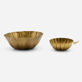
Josef Hoffmann, Floriform bowls, set of twoToomey & Co. Auctioneers4.7(391)See Sold PriceFeb 29, 2024
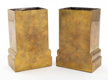
Josef Hoffmann Wiener Werkstatte Brass Vases, PairAuctions at Showplace4.6(731)See Sold PriceApr 07, 2024
Rare 19thc Colton Map, Argentine Republic, Chile, Uruguay, PataguayConnoisseur Auctions3.9(335)See Sold PriceMar 16, 2024