Sold16TH C. MAP OF GERMANY BY MUNSTER"Tabula Germaniae", Germany, Strabonis Ptolemeic map of part of northern Germany by Sebastian Munster (1488-1552), Basle, circa 1545. Copperplate engraving on laid paper, in water gilt molded stick frSee Sold Price
Sold16TH C. MAP OF GERMANY BY MUNSTER"Tabula Germaniae", Germany, Strabonis Ptolemeic map of part of northern Germany by Sebastian Munster (1488-1552), Basle, circa 1545. Copperplate engraving on laid paper, in water gilt molded stick frSee Sold Price
Sold16th C. Copper Engraving Paris w/ Ancient City WallsEurope, probably printed in Cologne, Germany, ca. last quarter of the 16th century CE. A copper engraved, hand-colored town plan of 16th century Paris, based upon a map made by Sebastian Munster in 15See Sold Price
(3) RARE 17TH C. SANSON MAPS OF GERMANYAlexis-Hubert Jaillot (c. 1632-1712); Nicolas Sanson (1600-1667). All single sheet, including: "Le Duce de Iuliers"; "l'Evesche de Munster"; Le Comte de la Marck", hand colored engravings, published 1See Sold Price
Sold(3) RARE 17TH C. SANSON MAPS OF GERMANYAlexis-Hubert Jaillot (c. 1632-1712); Nicolas Sanson (1600-1667). All single sheet, including: "Le Duce de Iuliers"; "l'Evesche de Munster"; Le Comte de la Marck", hand colored engravings, published 1See Sold Price
SoldFramed Map Hannonia NamurcumFramed map Hannonia Namurcum detailed map of regional Germany by Gerard Mercator, Belgium, 16th c., no date 14 3/4" x 19 1/2" site, matted and framed 20 1/2" x 25". CONDITION: Center fold line with teSee Sold Price
1598 c. Munster View of Heidelberg, Germany -- DerTitle/Content of Map: 1598 c. Munster View of Heidelberg, Germany -- Der loeblischen und weichesandten Statt Heydelberg… Cartographer: S Munster Year/Place: 1598 c., Basel Size: 10.1 X 28 in. This iSee Sold Price
SoldA 16th Century Woodcut Map of Poland, Lithuania, theMunster, c.1540, Woodcut map titled 'Polonia et Ungaria XV Nova Tabula', showing Poland, Lithuania, the Ukraine, Moscovy and the Balkans, extending from Prussia, Vilna and Smolensky in the north to BoSee Sold Price
1598 Munster Map of Western Germany and the Netherlands -- Die Dritte Tafel des RheinstromTitle: 1598 Munster Map of Western Germany and the Netherlands -- Die Dritte Tafel des Rheinstrom Innhaltend das Nider Teutschlandt Cartographer: S Munster Year / Place: 1598 c., Basel Map Dimension (See Sold Price
1598 Munster Map of Western Germany and the NetherlandsTitle: 1598 Munster Map of Western Germany and the Netherlands -- Die Dritte Tafel des Rheinstrom Innhaltend das Nider Teutschlandt Cartographer: S Munster Year / Place: 1598 c., Basel Map Dimension (See Sold Price
1598 Munster Map of Western Germany and the NetherlandsTitle: 1598 Munster Map of Western Germany and the Netherlands -- Die Dritte Tafel des Rheinstrom Innhaltend das Nider Teutschlandt Cartographer: S Munster Year / Place: 1598 c., Basel Map Dimension (See Sold Price
1598 Munster Map of Western Germany and the NetherlandsTitle/Content of Map: 1598 Munster Map of Western Germany and the Netherlands -- Die Dritte Tafel des Rheinstrom Innhaltend das Nider Teutschlandt Cartographer: S Munster Year/Place: 1598 c., Basel SiSee Sold Price
Two early maps of Germany1) S. Munster, "De Germania, Liber II: Civitas Augustana olim Vindelica …" from Cosmographia, Latin edition (Basel: c. 1552) folio, woodcut; 2) J. Russell, "Germany, divided into its great circles,"See Sold Price
SoldMunster: Antique Map of the Iberian Peninsula, 1550Title: Tabula Europae II, Lovely mid-16th century woodblock map of the Iberian Peninsula Map maker: Sebastian Münster, Cosmographiae Universalis... Place and Year: Basel, c. 1550 Dimensions: 35.3 x 2See Sold Price
Sold1598 Munster View of Simmern, Germany -- Die StattTitle/Content of Map: 1598 Munster View of Simmern, Germany -- Die Statt Siemern mit Aller ihrer Gelegenheit … Cartographer: S Munster Year/Place: 1598 c., Basel Size: 9.7 X 15.2 in. This is a ratheSee Sold Price
1598 Munster View of Speyer, Germany -- Die ReichsstattTitle/Content of Map: 1598 Munster View of Speyer, Germany -- Die Reichsstatt Speier, so vor Zeiten Civitas Nemetum: das ist, Nemeter Statt, hat Geheissen Cartographer: S Munster Year/Place: 1598 c.,See Sold Price
1598 Munster View of Meissen, Germany -- MisenaTitle/Content of Map: 1598 Munster View of Meissen, Germany -- Misena Hermundurorum Urbs Cartographer: S Munster Year/Place: 1598 c., Basel Size: 6.2 X 15.3 in. This is a rather striking double-page vSee Sold Price
1598 Munster View of Freiberg, Germany -- Die StattTitle/Content of Map: 1598 Munster View of Freiberg, Germany -- Die Statt Freyberg…. Cartographer: S Munster Year/Place: 1598 c., Basel Size: 8 X 11.4 in. This is an excellent birds-eye view of theSee Sold Price
1598 Munster View of Simmern, Germany -- Die StattTitle/Content of Map: 1598 Munster View of Simmern, Germany -- Die Statt Siemern mit Aller ihrer Gelegenheit … Cartographer: S Munster Year/Place: 1598 c., Basel Size: 9.7 X 15.2 in. Description: ThSee Sold Price
1598 Munster View of Freiberg, Germany -- Die StattTitle/Content of Map: 1598 Munster View of Freiberg, Germany -- Die Statt Freyberg…. Cartographer: S Munster Year/Place: 1598 c., Basel Size: 8 X 11.4 in. Description: This is an excellent birds-eyeSee Sold Price
1598 Munster View of Landau, Germany -- BahreTitle/Content of Map: 1598 Munster View of Landau, Germany -- Bahre Contrasehtung der Reichstatt Landaw… Cartographer: S Munster Year/Place: 1598 c., Basel Size: 6.7 X 14.8 in. Description: This isSee Sold Price
1598 Munster View of Landau, Germany -- BahreTitle/Content of Map: 1598 Munster View of Landau, Germany -- Bahre Contrasehtung der Reichstatt Landaw… Cartographer: S Munster Year/Place: 1598 c., Basel Size: 6.7 X 14.8 in. This is a superb woodSee Sold Price
1598 Munster View of Speyer, Germany -- Die ReichsstattTitle/Content of Map: 1598 Munster View of Speyer, Germany -- Die Reichsstatt Speier, so vor Zeiten Civitas Nemetum: das ist, Nemeter Statt, hat Geheissen Cartographer: S Munster Year/Place: 1598 c.,See Sold Price
SoldBavaria / Southern Germany c. 1550Map Title: Sveviae Et Bavariae Descriptio Published: Munster, S., Basel Date: c. 1550 Size: 10 5/8 x 13 1/2 inches. An attractive early woodcut map of Bavaria/ Southern Germany. A picturesque, early wSee Sold Price
17TH C. ANTIQUE MAP SIEGE OF LA ROCHELLE, FRANCE, FRAMEDThomaston Place Auction Galleries4.4(386)See Sold PriceFeb 24, 2024
EARLY 18TH C. MAP OF ITALY, FRAMEDThomaston Place Auction Galleries4.4(386)See Sold PriceFeb 24, 2024
LATE 16TH C. MAP OF SCOTLAND BY MERCATOR, FRAMEDThomaston Place Auction Galleries4.4(386)See Sold PriceFeb 24, 2024
17TH C. MAP OF THE BERKSHIRES BY JOHN SPEED, FRAMEDThomaston Place Auction Galleries4.4(386)See Sold PriceFeb 24, 2024
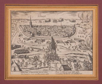
16TH C. BIRDSEYE VIEW OF SEIGE OF STEENWYCK, NETHERLANDS BY FRANS HOGENBERG (1535-1590)Thomaston Place Auction Galleries4.4(386)See Sold PriceFeb 24, 2024
16th C. African Agate Bead on Hand Strung Macrame StrandMaterial Culture4.6(765)See Sold PriceFeb 29, 2024
Early Ottoman Silk and Metal Thread Textile Fragment, 16th C.Material Culture4.6(765)See Sold PriceFeb 29, 2024
16th C. Spanish Silver Cob Coin (Macuquina) - 0.9 gArtemis Fine Arts4.8(1.4k)See Sold PriceFeb 26, 2024
16th C North Italy Wood Icon w/ Mary & ChristWorld Auction Gallery LLC4.7(261)See Sold PriceMar 10, 2024
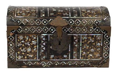
16TH C. JAPANESE MOMOYAMA INLAID LACQUERED CASKET.William Smith Auctions4.6(146)See Sold PriceMar 06, 2024