ATLAS of ANTIENT GEOGRAPHY by SAMUEL BUTLER 1843John McInnis Auctioneers,LLC4.5(505)See Sold PriceFeb 24, 2024
18TH C. ANTIQUE MAP: FRENCH & INDIAN WAR, FRAMEDThomaston Place Auction Galleries4.4(393)See Sold PriceFeb 24, 2024
Rand McNally Railroad Map Cabinet w/ 21 Railroad MapsRail & Road Auctions4.6(165)See Sold PriceMar 08, 2024
Keith Haring - Ink on New York Map, Best Buddies, Inscribed, Signed, and DatedSapphire Auction Gallery4.1(67)See Sold PriceMar 02, 2024
LATE 17TH C. FRENCH MAP OF THE NEW WORLD BY ALEXIS-HUBERT JAILLOT (1632-1712)Thomaston Place Auction Galleries4.4(393)See Sold PriceFeb 24, 2024
Central Railroad of New Jersey Map of Sandy Hook Route-ca. 1903JM Hobby Supply and Railroad Artifact Auctions4.4(127)See Sold PriceFeb 24, 2024
Lot of Six Mixed Atlas Box Cars-HO Scale-New in BoxJM Hobby Supply and Railroad Artifact Auctions4.4(127)See Sold PriceFeb 25, 2024
Rand McNally/Santa Fe Railroad Map of Iowa-1912JM Hobby Supply and Railroad Artifact Auctions4.4(127)See Sold PriceFeb 24, 2024
NICOLAES VISSCHER (NETHERLANDS, 1618-1709) MAP OF THE NEW WORLDThomaston Place Auction Galleries4.4(393)See Sold PriceFeb 24, 2024
17TH C. WORLD MAP BY NICOLAES VISSCHER (NETHERLANDS, 1618-1709)Thomaston Place Auction Galleries4.4(393)See Sold PriceFeb 24, 2024
Lot of Six Mixed Atlas Cabooses-HO Scale-New in BoxJM Hobby Supply and Railroad Artifact Auctions4.4(127)See Sold PriceFeb 25, 2024
Hondius, H.; Janssonius, J. Map Set (4 Maps)Hondius, Henricus; Janssonius, Johannes Untitled C. 1631 Copperplate engraving; coloured Printed area of each: 53.3 x 39.7 cm; 21 x 15.6 in A famous map-set, originally published separately as a map oSee Sold Price
Normandy region of France. 1638-50. By J. Janssonius &Normandy region of France. 1638-50. By J. Janssonius & H. Hondius.. 23 x 19 1/4”. Please note that this lot has a confidential reserve. When you leave a bid in advance of the auction, submit your maSee Sold Price
Mercator, R.; Hondius, J. Important Set of Five MapsMercator, Rumhold; Hondius, Jodocus Important Set of Five Maps C. 1609 Copperplate engraving; coloured World: 29 x 52.5 cm; 11.4 x 20.6 in Europe: 37.5 x 46 cm; 14.7 x 18.1 in Africa: 38 x 47,5 cm; 14See Sold Price
SoldGuiana sive Amazonum Regio, Jansson & Hondius 1636Title: Guiana sive Amazonum Regio Subject: Venezuela, Brazil, Guyana, Suriname, Amazon Maker: J. Janssonius and H. Hondius Date: 1636, Amsterdam Size: 14.75 x 19.25 inches This map depicts the vital aSee Sold Price
Sold[United States]. 4 Maps.[United States]. 4 Maps. ++ Lake Superior And The Northern Part Of Michigan. J. H. Colton: 1855. 11 1/2 x 13 3/4, hand-colored. Corners torn, minor edgewear, map unaffected. ++ Map Of The Central StatSee Sold Price
SoldNeele (S. J.) maps of the 4 HemispheresNeele (S. J.) maps of the 4 Hemispheresthe set of 4 from Pinkerton's Modern Atlas, engraved circular maps, with full hand-colouring, each c.555 x 765mm., central vertical folds, trimmed withinSee Sold Price
SoldCOLTON, J. H. Colton's Map of the United StateCOLTON, J. H. Colton's Map of the United States of America, the British Provinces, Mexico and the West Indies. Hand-colored engraved wall map from 4 joined sheets, 1325x1520 mm overall; varnish with vSee Sold Price
SoldCOLTON, J. H. Colton's Map of the United StateCOLTON, J. H. Colton's Map of the United States of America, the British Provinces, Mexico and the West Indies. Hand-colored engraved wall map from 4 joined sheets, 1325x1500 mm overall; small 40x40 mmSee Sold Price
SoldCOLTON, J. H. Colton's Map of the United StateCOLTON, J. H. Colton's Map of the United States of America, the British Provinces, Mexico and the West Indies. Hand-colored engraved wall map from 4 joined sheets, 1340x1520 mm overall; two tears enteSee Sold Price
SoldAntique map lot, Brazil & South America, includes 4Antique map lot, Brazil & South America, includes 4 maps, "South America", by J & F Tallis, London, Edinburgh & Dublin; "Amerique Meridionale", Giraldon; "Brasil, Divided into its Captainships", H. MoSee Sold Price
Sold15 maps (13 w/ orig. hand coloring) + 1 atlas[United States]. 15 Color Maps + 1 Facsimile Atlas. Good - very good condition. ++ J. H. Young. Map Of Minnesota Territory. Phila: Thomas Cowperthwait, (1850). 12 3/8 x 15 1/4 in. ++ 2 maps from Cram'See Sold Price
U.S GOVERNMENT SURVEY COPPER MAP PLATES, SET OF 4Livingston, MT 1886-1887 US Government Copper Map Engravings for Livingston, MT, scale 1:125,000 surveyed 1886-1887. The Original Master Set engraved on 4 plates measure approximately 21 in. H x 17 inSee Sold Price
U.S GOVERNMENT SURVEY COPPER MAP PLATES, SET OF 4Livingston, MT 1886-1887 US Government Copper Map Engravings for Livingston, MT, scale 1:125,000 surveyed 1886-1887. The Original Master Set engraved on 4 plates measure approximately 21 in. H x 17 inSee Sold Price
SoldJ. H. Colton's Map of the Southern States.MAP - J. H. COLTON. J. H. Colton's Map of the Southern States.New York: Colton, 1864. Large 4-sheet hand-colored engraved map by J. Calvin Smith (1000 x 1370 mm). Two insets. Within a decorSee Sold Price
SoldSpice Islands Indonesia/ Moluccas, 1636Map Title: Insularum Moluccarum Nova descriptio (The Fabled Spice Islands Indonesia/ Moluccas) Published: Hondius, H./ Jansson, J., Amsterdam Date: 1636 Size: 15 x 19 1/2 inches (engraved surface exclSee Sold Price
Czech Republic 1636Map Title: Marchionatus Moraviae Auct. J. Comenio (With English Text) Published: Hondius, H./ Jansson, J. Amsterdam Date: 1636 Size: 15.25 x 21.5 inches. Finely detailed map from the scarce English teSee Sold Price
1630 Hondius / Mercator Map of Japan and Korea - IaponiJ. Hondius / G. Mercator 1630 c. Amstredam 13.4 x 17.4 in. This superb map is one of the earliest Western rendering of Japan, based on the Ortelius/Teixeira model with the three principal Japanese IslSee Sold Price
Hondius / Mercator Map of Japan and Korea, 1630Map: 1630 Hondius / Mercator Map of Japan and Korea - Iaponia Cartographer: J. Hondius / G. Mercator Year / Place: 1630 c. Amstredam Map Dimension: 13.4 x 17.4 in. This superb map is one of the earlieSee Sold Price
Colton: Antique Map of Southern Regions, 1861Map: Southern Regions Date Printed: 1861 Cartographer: J. H. Colton Material/Medium: Paper Size: 14" x 17 1/4" Hand colored engraved Map. From 'Colton's General Atlas'. Published in New York. Please nSee Sold Price
Rare J.H. Colton Color Map of Iowa and Minnesota19th Century J.H. Colton’s map of Iowa and Minnesota - color map set on backing board and shrink wrapped. 11 1/2”W X 14”HSee Sold Price
SoldRare J.H. Colton Color Map of Iowa and Minnesota19th Century J.H. Colton’s map of Iowa and Minnesota - color map set on backing board and shrink wrapped. 11 1/2”W X 14”HSee Sold Price
SoldRare J.H. Colton Color Map of Iowa and Minnesota19th Century J.H. Colton’s map of Iowa and Minnesota - color map set on backing board and shrink wrapped. 11 1/2”W X 14”HSee Sold Price
Rare J.H. Colton Color Map of Iowa and Minnesota19th Century J.H. Colton’s map of Iowa and Minnesota - color map set on backing board and shrink wrapped. 11 1/2”W X 14”HSee Sold Price
Sold1857 Rockingham County, New Hampshire Map(1) Rockingham County. Surveys by J. Chace. Published by Smith & Coffin. Philadelphia 1857. Roll down school map. 4' 11"w x 4' 11"h. Paper on canvas backSee Sold Price
MARTINET / DE VRIES Catechism of Nature 4 Vol. Set c1788 Engravings Rare!Luis Porretta Fine Arts4.3(10)See Sold PriceMar 02, 2024
19thc Colton Map, Comparitive Size of Lakes & IslandsConnoisseur Auctions3.9(336)See Sold PriceFeb 24, 2024
18K White Gold 75.40ct Sapphire and 17.95ct Diamond Necklace and Earring SetRiverside Galleries4.5(181)See Sold PriceFeb 26, 2024
1738 BIBLE in DUTCH ILLUSTRATED w/ MAPS MASSIVE FOLIO in DUTCH antique BIBLIAJasper524.5(9.9k)See Sold PriceFeb 27, 2024
1711 GREEK BIBLE ILLUSTRATED w/ MAPS VELLUM BOUND antique NEW TESTAMENTJasper524.5(9.9k)See Sold PriceFeb 27, 2024
1730 BIBLE in DUTCH ILLUSTRATED w/ MAPS antique MASSIVE FOLIO BIBLIAJasper524.5(9.9k)See Sold PriceFeb 27, 2024
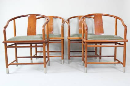
Set of 4 Stanley J. Friedman for Brueton, Chinese "Mao Chair"PUBLIC SALE4.7(226)See Sold PriceMar 02, 2024
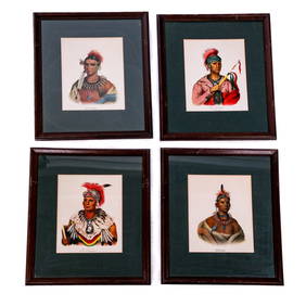
Carl J. Sundevall (1801 - 1875) Set of 4 Bird Prints - Dove - Woodpecker - DuckProverde Auctions4.3(3)See Sold PriceFeb 28, 2024
Set of 4 Maps - Netherlands - Seven United Provinces - Germany - Sweden, Denmark, Norway, FinlandProverde Auctions4.3(3)See Sold PriceFeb 28, 2024
Set of 3 Maps - Netherlands - Belgien - Switzerland - J. BarlowProverde Auctions4.3(3)See Sold PriceFeb 28, 2024
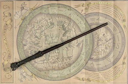
Universal Studios Harry Potter Wand BRapid Estate Liquidators and Auction Gallery4.5(1.1k)See Sold PriceFeb 28, 2024


![[United States]. 4 Maps. (1 of 1)](https://p1.liveauctioneers.com/179/1435/617538_1_x.jpg?height=282&quality=70)