ATLAS of ANTIENT GEOGRAPHY by SAMUEL BUTLER 1843John McInnis Auctioneers,LLC4.6(502)See Sold PriceFeb 24, 2024
18TH C. ANTIQUE MAP: FRENCH & INDIAN WAR, FRAMEDThomaston Place Auction Galleries4.4(386)See Sold PriceFeb 24, 2024
Rand McNally Railroad Map Cabinet w/ 21 Railroad MapsRail & Road Auctions4.6(165)See Sold PriceMar 08, 2024
Keith Haring - Ink on New York Map, Best Buddies, Inscribed, Signed, and DatedSapphire Auction Gallery4(67)See Sold PriceMar 02, 2024
LATE 17TH C. FRENCH MAP OF THE NEW WORLD BY ALEXIS-HUBERT JAILLOT (1632-1712)Thomaston Place Auction Galleries4.4(386)See Sold PriceFeb 24, 2024
Central Railroad of New Jersey Map of Sandy Hook Route-ca. 1903JM Hobby Supply and Railroad Artifact Auctions4.4(126)See Sold PriceFeb 24, 2024
Lot of Six Mixed Atlas Box Cars-HO Scale-New in BoxJM Hobby Supply and Railroad Artifact Auctions4.4(126)See Sold PriceFeb 25, 2024
Rand McNally/Santa Fe Railroad Map of Iowa-1912JM Hobby Supply and Railroad Artifact Auctions4.4(126)See Sold PriceFeb 24, 2024
NICOLAES VISSCHER (NETHERLANDS, 1618-1709) MAP OF THE NEW WORLDThomaston Place Auction Galleries4.4(386)See Sold PriceFeb 24, 2024
17TH C. WORLD MAP BY NICOLAES VISSCHER (NETHERLANDS, 1618-1709)Thomaston Place Auction Galleries4.4(386)See Sold PriceFeb 24, 2024
Lot of Six Mixed Atlas Cabooses-HO Scale-New in BoxJM Hobby Supply and Railroad Artifact Auctions4.4(126)See Sold PriceFeb 25, 2024
Late 1800's Atlas Map of Denmarkc.1895 colored Map of Denmark, from Rand, McNally & Co's Atlas Of The World. 11" X 14".See Sold Price
Late 1800's Atlas Map of Denmarkc.1895 colored Map of Denmark, from Rand, McNally & Co's Atlas Of The World. 11" X 14".See Sold Price
Late 1800's Atlas Map of Denmarkc.1895 colored Map of Denmark, from Rand, McNally & Co's Atlas Of The World. 11" X 14".See Sold Price
Late 1800's Atlas Map of Denmarkc.1895 colored Map of Denmark, from Rand, McNally & Co's Atlas Of The World. 11" X 14".See Sold Price
Late 1800's Atlas Map of Denmarkc.1895 colored Map of Denmark, from Rand, McNally & Co's Atlas Of The World. 11" X 14".See Sold Price
Late 1800's Atlas Map of Hawaii1890's map of Hawaii, from an Atlas Of The World. 11" X 14".See Sold Price
Late 1800's Atlas Map of Hawaii1890's color map of Hawaii, from an Atlas Of The World. 11" X 14".See Sold Price
Late 1800's Atlas Map of Hawaii1890's color map of Hawaii, from an Atlas Of The World. 11" X 14".See Sold Price
Late 19thc Atlas Map of Denmarkc.1895 colored Map of Denmark, from Rand, McNally & Co's Atlas Of The World. 11" X 14".See Sold Price
Late 19thc Atlas Map of Denmarkc.1895 colored Map of Denmark, from Rand, McNally & Co's Atlas Of The World. 11" X 14".See Sold Price
Sold1800 Geography ATLAS MAPS John Walker India Asia World1800 Geography ATLAS MAPS John Walker India Asia World Map John Walker’s ‘Elements of Geography’ is an incredibly late 18th-century English atlas known for its impressive folding maps. This atlaSee Sold Price
Sold(3) NEW JERSEY MAPS & (1) NEW YORK MAP, LATE 1800'SAll feature colored highlights, all originally removed from an atlas; paper is brittle; Includes: (1) "Atlas of New Jersey Counties of Camden, Salem and Gloucester"; engraved by E Busch, 320 Walnut StSee Sold Price
Antique Late 1800s Era Large Investment MapRand McNalley Railroad investment map of the late 1800's. Said to have been in the first National Bank of Chicago. Depicts the Great Lakes area and northeastern United States with hand drawn railroadSee Sold Price
Late 1800's Map of South AmericaLate 1800's reference map no. 10 of South America. A block at top right showing the route of the railroad & Panama canal, with size comparison showing the state of Ohio. 9" X 11". * reverse side printSee Sold Price
Late 1800's Map of South AmericaLate 1800's reference map no. 10 of South America. A block at top right showing the route of the railroad & Panama canal, with size comparison showing the state of Ohio. 9" X 11". * reverse side printSee Sold Price
Sold(4) LATE 1800'S MARYLAND MAPSIncludes: "Northeast District No. 5", includes vignette for Principio Furnace; loss to lower left corner; centerfold 26 3/8" x 16 1/4" (1) double sided atlas page, G. W. Gray & Son, 1876, page 61 "GraSee Sold Price
SoldEarly Map of Melbourne, Iowa ca. Late 1800sEarly map of Melbourne, Iowa ca. late 1800s. Frame size: 20" H x 16" W x 3/4" D.See Sold Price
Wavecrest Hinged Ormolu and Footed Powder Box - late 1800sTitle: Wavecrest Hinged Ormolu and Footed Powder Box - late 1800s Category: Boxes>Wavecrest Glass>ormolu Description:This Wavecrest Hinged Box is very interesting in that it has an ormolu footed baseSee Sold Price
Carte Politique De L'Europe Et De L'Empire FrancaisMap: Carte Politique Et Itineraire De L'europe Et De L'empire Francais en 1807 Maker: Hyacinthe Langlois Material: Wooden frame Date: Late 1800's, early 1900's Size: 19 x 14.25 inches Please note thatSee Sold Price
SoldNorthern Pacific Railway Yellowstone Park MapThis is a Northern Pacific Railway map of Yellowstone National Park. The map shows the very early roads and wagon trails used in the late 1800's. The top is marked "Northern Pacific Railway" and the bSee Sold Price
SoldVintage CRAM's IMPERIAL WORLD GLOBE on Stand:Vintage CRAM's IMPERIAL WORLD GLOBE on Stand: Natural Scale 1=41,8000,000. The George F. Cram Co. was one of the Most Prominent Map and Globe Producers from the Late 1800's till 2012. Mahogany Three LSee Sold Price
SoldThree Turn of the 19th C. Montana County MapsThis lot offers you three late 1800's - early 1900's Montana county line maps. The lot includes a 1897-00, 24 county map, 1901-1904, 26 county map, and finally, a 1911, 29 county map. The 1897, and 19See Sold Price
SoldFramed Geographica Map Engraving (28E-EK)Framed Authentic Nova Totius Terrarum Orbis Geographica AC Hydrographica Tabula Map. Mixed Engraving printed in the late 1800's to early 1900's. All have the Mixed stamp from the Museum. These are theSee Sold Price
Framed Geographica Map Engraving (28E-EK)Framed Authentic Nova Totius Terrarum Orbis Geographica AC Hydrographica Tabula Map. Mixed Engraving printed in the late 1800's to early 1900's. All have the Mixed stamp from the Museum. These are theSee Sold Price
LATE 16TH C. MAP OF SCOTLAND BY MERCATOR, FRAMEDThomaston Place Auction Galleries4.4(386)See Sold PriceFeb 24, 2024
1849 Mitchell School ATLAS 24 MAPS America Holy Land France Africa Egypt AsiaSchilb Antiquarian Rare Books4.8(421)See Sold PriceMar 31, 2024
Fire King Vintage Cigar Label Stone Lithograph Art Dated from the late 1800's to early 1900's.North American Artifact Auctions4.6(182)See Sold PriceApr 20, 2024
Sandow Vintage Cigar Label Stone Lithograph Art Dated from the late 1800's to early 1900's. InnerNorth American Artifact Auctions4.6(182)See Sold PriceApr 20, 2024
Travis Club Vintage Cigar Label Stone Lithograph Art Dated from the late 1800's to early 1900's.North American Artifact Auctions4.6(182)See Sold PriceApr 20, 2024
Delaware Vintage Cigar Label Stone Lithograph Art Dated from the late 1800's to early 1900's. InnerNorth American Artifact Auctions4.6(182)See Sold PriceApr 20, 2024
Polar Light Vintage Cigar Label Stone Lithograph Framed Art Dated from the late 1800's to earlyNorth American Artifact Auctions4.6(182)See Sold PriceApr 20, 2024
Vintage Cigar Labels Group of 6 Dated from the late 1800's to early 1900's. Includes The Raven,North American Artifact Auctions4.6(182)See Sold PriceApr 20, 2024
Vintage Cigar Labels Misc. Group Dated from the late 1800's to early 1900's. Includes Tony's,North American Artifact Auctions4.6(182)See Sold PriceApr 20, 2024
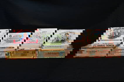
Group of 4 Vintage Wood Cigar Boxes Dated from the late 1800's to early 1900's. Includes CharlesNorth American Artifact Auctions4.6(182)See Sold PriceApr 20, 2024
Vintage Black Hawk Wood Cigar Box Dated from the late 1800's to early 1900's. Andy Dehner CigarNorth American Artifact Auctions4.6(182)See Sold PriceApr 20, 2024
Edmond Dantes, The Count of Monte Cristo by Dumas, Alexander (late 1800's)North American Artifact Auctions4.6(182)See Sold PriceApr 20, 2024
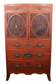
CIRCA LATE 1800's EDWARDIAN LINEN PRESSLewis & Maese Antiques & Auction4.4(520)See Sold PriceFeb 25, 2024
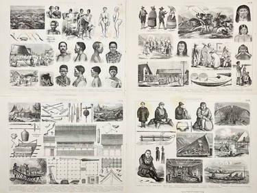
Battle of the Nile: Disposition of the English & French Fleets, at the Commencement of the Action,Trillium Antique Prints & Rare Books4.5(30)See Sold PriceFeb 24, 2024
Friedrich Arnold Brockhaus - Set of 4 Prints - Anthropologic Lithography - Sudan - Sennar - Africa -Proverde Auctions4.3(3)See Sold PriceFeb 28, 2024
Friedrich Arnold Brockhaus - Set of 4 Prints - Anthropologic Lithography - Ethnography - Africa -Proverde Auctions4.3(3)See Sold PriceFeb 28, 2024
B&G Bing & Grondahl biscuit plate after Thorvaldsen. Late 1800 s.Jasper524.5(9.8k)See Sold PriceFeb 27, 2024