ATLAS of ANTIENT GEOGRAPHY by SAMUEL BUTLER 1843John McInnis Auctioneers,LLC4.5(505)See Sold PriceFeb 24, 2024
18TH C. ANTIQUE MAP: FRENCH & INDIAN WAR, FRAMEDThomaston Place Auction Galleries4.4(393)See Sold PriceFeb 24, 2024
Rand McNally Railroad Map Cabinet w/ 21 Railroad MapsRail & Road Auctions4.6(165)See Sold PriceMar 08, 2024
Keith Haring - Ink on New York Map, Best Buddies, Inscribed, Signed, and DatedSapphire Auction Gallery4(67)See Sold PriceMar 02, 2024
LATE 17TH C. FRENCH MAP OF THE NEW WORLD BY ALEXIS-HUBERT JAILLOT (1632-1712)Thomaston Place Auction Galleries4.4(393)See Sold PriceFeb 24, 2024
Central Railroad of New Jersey Map of Sandy Hook Route-ca. 1903JM Hobby Supply and Railroad Artifact Auctions4.4(127)See Sold PriceFeb 24, 2024
Lot of Six Mixed Atlas Box Cars-HO Scale-New in BoxJM Hobby Supply and Railroad Artifact Auctions4.4(127)See Sold PriceFeb 25, 2024
Rand McNally/Santa Fe Railroad Map of Iowa-1912JM Hobby Supply and Railroad Artifact Auctions4.4(127)See Sold PriceFeb 24, 2024
NICOLAES VISSCHER (NETHERLANDS, 1618-1709) MAP OF THE NEW WORLDThomaston Place Auction Galleries4.4(393)See Sold PriceFeb 24, 2024
17TH C. WORLD MAP BY NICOLAES VISSCHER (NETHERLANDS, 1618-1709)Thomaston Place Auction Galleries4.4(393)See Sold PriceFeb 24, 2024
Lot of Six Mixed Atlas Cabooses-HO Scale-New in BoxJM Hobby Supply and Railroad Artifact Auctions4.4(127)See Sold PriceFeb 25, 2024
SoldWilliams & Rapkin 1857 Map of British IndiaSteel Engraved Map Published 1857, London for "England's Battles by Sea and Land..." by Lieut-Colonel Williams. Centre fold as published. Drawn and Engraved by J. Rapkin. Paper Size: 13.75 x 10.5 inchSee Sold Price
SoldWilliams & Rapkin 1857 Map of Northern IndiaSteel Engraved Map Published 1857, London for "England's Battles by Sea and Land..." by Lieut-Colonel Williams. Centre fold as published. Drawn and Engraved by J. Rapkin. Paper Size: 13.75 x 10.5 inchSee Sold Price
Sold1857 Life of Charles Napier British INDIA Sindh1857 Life of Charles Napier British INDIA Sindh Conquests Peninsular War MAP 4v William Francis Napier was a 19th-century British soldier known for his books on military history. Napier’s biographySee Sold Price
SoldJ Rapkin - Antique Map of British IndiaItem: J Rapkin - Antique Map of British India Description: Antique map of British India drawn and engraved by J Rapkin. Dimensions: 14.5x11 Please note that this lot has a confidential reserve. When ySee Sold Price
Tallis / Rapkin: Antique Map of British India, 1858Title/Content of Map: 'British India' Railways. Military bases. Mutiny events. Date Printed: 1858 Image Size: Approx 33.5 x 25.5cm, 13.25 x 10 inches (Large) Type: Antique steel engraved map with origSee Sold Price
SoldTallis, John (Pub) 1852 Map. British IndiaSteel Engraved Map with Original Outline Hand Color Published 1852-56 by John Tallis, London for "The Universal Pronouncing Dictionary" by Thomas Wright. Drawn & Engraved by John Rapkin. Centre fold aSee Sold Price
Sold2 maps of India by TallisTitle: Two maps, Northern India [and] British India Author: Tallis, John Description: Includes: * British India. Map drawn & engraved by J. Rapkin. Illustrations by A.H. Wray, engraved by G. GreatbachSee Sold Price
19th C Antique Map of British IndiaMap: Map of British India Maker: John Rapkin Date: 19th century Map Size: 14.5 x 11 inches Frame Size: 22 x 18 inches John Rapkin (1815-1876) drew and engraved the maps for John Tallis’ renowned "IlSee Sold Price
Sold1775 BENGAL East India Trading Co South ASIA Hindu Brit1775 BENGAL East India Trading Co South ASIA Hindu British MAP William Bolts William Bolts was an 18th-century Dutch merchant who worked predominantly for the British East India Company; however, he gSee Sold Price
Sold1851 British India & Denmark MapsUnframed c. 1851 John Tallis & Company published steel lined engraved maps of British India & Denmark, both are engraved by J. Rapkin, British India is illustrated by A. H. Wray engraved by G. GreatbaSee Sold Price
SoldColton: Hindostan (British India) MapHindostan (or British India), 14 x 17 in, 1857, J. H. Colton Please note that this lot has a confidential reserve. When you leave a bid in advance of the auction, submit your maximum. Jasper52 will biSee Sold Price
SoldColton: Map of Hindostan Or British India, 1857Title: Map of Hindostan Or British India by Colton Date: 1857 Dimensions: 14 x 17 Medium: Hand Colored Lithograph Please note that this lot has a confidential reserve. When you leave a bid in advanceSee Sold Price
SoldRapkin, John 1860 Map of India"British India" Steel Engraved Map Published 1860 by The London Printing & Published Company, London for "The Royal Dictionary-Cyclopedia for Universal Reference" by Thomas Wright. Drawn & Engraved bySee Sold Price
BRITISH INDIA MAPILLUSTRATIONS BY A.H. WRAY & ENGRAVED BY G. GREATBACH. THE MAP DRAWN & ENGRAVED BY J. RAPKIN. 13" BY 10 1/4"See Sold Price
SoldMap of India, 1857Original engraving from the London Illustrated News, December 5, 1857. Features chronological acquisitions of the British in India and distances between the principal cities and towns of India. DimensSee Sold Price
Map of India, 1857Original engraving from the London Illustrated News, December 5, 1857. Features chronological acquisitions of the British in India and distances between the principal cities and towns of India. DimensSee Sold Price
SoldMichael Sutty, Limited Edition porcelain figure, 'Michael Sutty, Limited Edition porcelain figure, ' Major William Hodson, Hodson's Horse ' 1857, from the series ' The Imperial Armies, the British Army in India ' No. 83 of 1000, 11.5ins highSee Sold Price
Tallis / Rapkin: Antique Map of Northern India, 1849Northern India' Includes Nepaul (Nepal) & Bhotan (Bhutan). Vignettes: The Seal of the East India Company; Car of Juggernaut; The British Residency - Hyderabad; Hindoos; Tiger Hunt (with hunters on eleSee Sold Price
SoldWilliam Faden "Map of the Peninsula of India…" 1792**Originally Listed At $300** William Faden (British, 1749-1836), "A Map of the Peninsula of India from the 19th Degree North Latitude to Cape Comorin, MDCCXCII" - published in London, 1792. An antiquSee Sold Price
William Faden "Map of the Peninsula of India…" 1792William Faden (British, 1749-1836), "A Map of the Peninsula of India from the 19th Degree North Latitude to Cape Comorin, MDCCXCII" - published in London, 1792. An antique 2-sheet map of India, with oSee Sold Price
William Faden "Map of the Peninsula of India…" 1792**Originally Listed At $300** William Faden (British, 1749-1836), "A Map of the Peninsula of India from the 19th Degree North Latitude to Cape Comorin, MDCCXCII" - published in London, 1792. An antiquSee Sold Price
William Faden "Map of the Peninsula of India…" 1792**Originally Listed At $300** William Faden (British, 1749-1836), "A Map of the Peninsula of India from the 19th Degree North Latitude to Cape Comorin, MDCCXCII" - published in London, 1792. An antiquSee Sold Price
SoldWILLIAM DARTON (1755-1819) British An Accurate Map ofWILLIAM DARTON (1755-1819) British An Accurate Map of Hindostan or India From the Best Authorities Engraving on laid paper, published May 23rd 1785 by C Dilly & G Robinson, London, framed and glazed.See Sold Price
Sold(CHINA) BRITISH ENVOY TO PEKING, WAR ON BURMA(CHINA) BRITISH ENVOY TO PEKING WAR ON BURMA WILLIAM PITT AMHERST 1st Earl Amherst (1773-1857) English diplomat; envoy to Peking (1816-17); Governor General of India (1823-28); conducted successful waSee Sold Price
A J HANDFORD British Lithographer Rome from Mount Aventi Signed c1910 FramedLuis Porretta Fine Arts4.3(10)See Sold PriceMar 02, 2024
MATTHEWS c1856 Map Of Upper Canada Ontario Indian Land Agency Divisions Scarce!Luis Porretta Fine Arts4.3(10)See Sold PriceMar 02, 2024
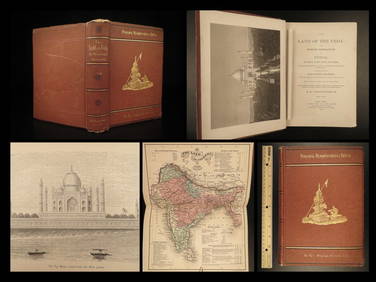
1872 INDIA Land of the Veda Travel Exploration Voyages Hindu Sepoy RebellionSchilb Antiquarian Rare Books4.8(428)See Sold PriceMar 31, 2024
D'Oyly (Calcutta, India) - Government House from St. Andrew's LibraryTrillium Antique Prints & Rare Books4.5(32)See Sold PriceFeb 24, 2024
D'Oyly (Calcutta, India) - Procession of the CurruckpoojaTrillium Antique Prints & Rare Books4.5(32)See Sold PriceFeb 24, 2024
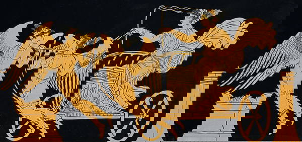
Hamilton - Engraving of a Painting from a Grecian Vase. 1Trillium Antique Prints & Rare Books4.5(32)See Sold PriceFeb 24, 2024
Hamilton - Engraving of a Painting from a Grecian VaseTrillium Antique Prints & Rare Books4.5(32)See Sold PriceFeb 24, 2024
Hamilton - Engraving of a Painting from a Grecian Vase. 2Trillium Antique Prints & Rare Books4.5(32)See Sold PriceFeb 24, 2024
Hamilton - Engraving of a Painting from a Grecian Vase. 32Trillium Antique Prints & Rare Books4.5(32)See Sold PriceFeb 24, 2024
Hamilton - Engraving of a Painting from a Grecian Vase. 114Trillium Antique Prints & Rare Books4.5(32)See Sold PriceFeb 24, 2024
Hamilton - Engraving of a Painting from a Grecian Vase. 5Trillium Antique Prints & Rare Books4.5(32)See Sold PriceFeb 24, 2024
William Took (British, 1857-1896) Cabin Along The River Bridge Oil on CanvasCV Auction LLC4.4(35)See Sold PriceMar 09, 2024
INDIA WITHIN THE GANGES SUSAN GOLE ILLUSTRATED MAPS EARLY CARTOGRAPHYJasper524.5(9.9k)See Sold PriceFeb 27, 2024
1792 OLD INDIA HISTORY ANTIQUE ILLUSTRATED WITH MAPS OF THE EIGHTEENTH CENTURY IN FRENCHNY Elizabeth 4.2(86)See Sold PriceMar 03, 2024
Benjamin Fawcett - Alexander Francis Lydon - British Fish - Bull TroutProverde Auctions4.3(3)See Sold PriceFeb 28, 2024
Benjamin Fawcett - Alexander Francis Lydon - British Fish - Allis Shad - Twaite ShadProverde Auctions4.3(3)See Sold PriceFeb 28, 2024