Marc Chagall-Limited Edition -Paris Opera Ceiling after ChagallArt Legacy Auctions4.5(217)See Sold PriceFeb 24, 2024
Salvador Dali Pantagruel Limited Edition Lithograph Hand signed and numberedArt Legacy Auctions4.5(217)See Sold PriceFeb 24, 2024
Pablo Picasso Bouquet of Peace Collection Domaine Picasso Limited Edition on paper.Art Legacy Auctions4.5(217)See Sold PriceFeb 24, 2024
A RARE MAXFIELD PARRISH JACK AND THE BEANSTALK PRINTSoulis Auctions4.8(953)See Sold PriceFeb 24, 2024
LARGE MECHANICAL PRINT 'STARS' AFTER MAXFIELD PARRISHSoulis Auctions4.8(953)See Sold PriceFeb 24, 2024
Heinrich Aldegrever, etc. 15 old master prints. 16th-17th centuries. Aldegrever works include "ManTremont Auctions4.6(293)See Sold PriceFeb 25, 2024
SoldStanford’s Map of India... 1857. Folding map.[India] Edward Stanford. Stanford’s Map of India Based on Surveys Executed by Order of the Honourable the East India Company, Special Maps of the Surveyor General and Other Authorities; Showing theSee Sold Price
SoldMap of India, 1857Original engraving from the London Illustrated News, December 5, 1857. Features chronological acquisitions of the British in India and distances between the principal cities and towns of India. DimensSee Sold Price
Map of India, 1857Original engraving from the London Illustrated News, December 5, 1857. Features chronological acquisitions of the British in India and distances between the principal cities and towns of India. DimensSee Sold Price
SoldColton: Map of Hindostan Or British India, 1857Title: Map of Hindostan Or British India by Colton Date: 1857 Dimensions: 14 x 17 Medium: Hand Colored Lithograph Please note that this lot has a confidential reserve. When you leave a bid in advanceSee Sold Price
Sold1857 Map of India by J. & C. Walker"Map of India". Engraved by J. & C. Walker and published by Wm. H. Allen & Co., Leadenhall Street, Aug.1st. 1857. Areas of age toning, some fold separations (with some tape repairs to reverse). FoldsSee Sold Price
Map of India – Engraved Map published 1857...Map of India – Engraved Map published 1857 to illustrate principle cities and towns, giving a perspective on the location of events during the Indian Mutiny/Rebellion, measures 30x43 overall, laid tSee Sold Price
SoldWilliams & Rapkin 1857 Map of British IndiaSteel Engraved Map Published 1857, London for "England's Battles by Sea and Land..." by Lieut-Colonel Williams. Centre fold as published. Drawn and Engraved by J. Rapkin. Paper Size: 13.75 x 10.5 inchSee Sold Price
SoldWilliams & Rapkin 1857 Map of Northern IndiaSteel Engraved Map Published 1857, London for "England's Battles by Sea and Land..." by Lieut-Colonel Williams. Centre fold as published. Drawn and Engraved by J. Rapkin. Paper Size: 13.75 x 10.5 inchSee Sold Price
SoldColton: Hindostan (British India) MapHindostan (or British India), 14 x 17 in, 1857, J. H. Colton Please note that this lot has a confidential reserve. When you leave a bid in advance of the auction, submit your maximum. Jasper52 will biSee Sold Price
MAPS IN BOOK, Atlases, ColtonAtlases. Joseph Hutchins Colton, Colton's Atlas of America, Illustrating the Physical and Political Geography of North and South America and the West India Islands..., 1857 (published). Hand Color. ThSee Sold Price
Sold1901 INDIAN MUTINY OF 1857, East India Company1901 INDIAN MUTINY OF 1857 - Colonel G B Malleson History Sepoy Rebellion, Maps, Plans, Portraits Written from the perspective of an English officer in India, this work examines the uprising in IndSee Sold Price
SoldHenry Howe HISTORICAL COLLECTIONS OF THE GREAT WESTHenry Howe HISTORICAL COLLECTIONS OF THE GREAT WEST 1857 Decorative Leather Binding Gilt Marbled Page Edges Illustrated India-Tinted Engravings Maps Western US History Frontier Oregon New Mexico TexasSee Sold Price
Sold1857 Life of Charles Napier British INDIA Sindh1857 Life of Charles Napier British INDIA Sindh Conquests Peninsular War MAP 4v William Francis Napier was a 19th-century British soldier known for his books on military history. Napier’s biographySee Sold Price
SoldMap of Jamoo and KashmirMap of Jamoo, Kashmir and Adjacent Districts Surveyed between the years 1856 & 1857. Linen backed very large foldout map of a province in India and published in the 1850s. Signed by Lieutenant Col SirSee Sold Price
Sold1859 INDIA 1ed History Indian Revolt Sepoy Mutiny Voyages MAP China Illustrated1859 INDIA 1ed History Indian Revolt Sepoy Mutiny Voyages MAP China Illustrated George Dodds “History of the Indian Revolt” is a rare account of the Indian Rebellion of 1857, or more commoSee Sold Price
SoldStanford Map of the AntillesSTANFORD, Edward (1827-1904). The Antilles or West India Islands. Lithograph with original hand color from the Society for the Diffusion of Useful Knowledge. London: Edward Stanford, 1857-1870. 17 1/4See Sold Price
SoldAULDJO, John (d. 1857). Narrative of an Ascent to theAULDJO, John (d. 1857). Narrative of an Ascent to the Summit of Mont Blanc. London: for Longman, Rees, et al, 1828. 4to (294 x 229 mm). 15 lithographed plates (7 on india paper mounted), 2 folding mapSee Sold Price
Sold1901 INDIAN MUTINY OF 18571901 INDIAN MUTINY OF 1857 - Colonel G B Malleson History Sepoy Rebellion, Maps, Plans, Portraits Written from the perspective of an English officer in India, this work examines the uprising in IndSee Sold Price
SoldJ. H. Colton: Cuba, Jamaica, & Porto Rico Map, 1857Map of Cuba, Jamaica, and Porto Rico, 16.75 x 14 in, 1857, J. H. Colton Please note that this lot has a confidential reserve. When you leave a bid in advance of the auction, submit your maximum. JaspeSee Sold Price
SoldWest Indies Map, 1857West Indies Map, 17 x 14 in, 1857, J. H. Colton Please note that this lot has a confidential reserve. When you leave a bid in advance of the auction, submit your maximum. Jasper52 will bid on your behSee Sold Price
SoldBarclay, James 1809 Antique Map. India & Ceylon"Hindoostan with the Island of Ceylon, Maldives &c &c" Outline Hand Coloured Copper Engraved Map Published 1809, Leeds for "Barclay's Complete and Universal Dictionary of the English Language..." by tSee Sold Price
SoldJ. H. Colton: Palestine Map, 1857Palestine, 14 x 17 in, 1857, J. H. Colton Please note that this lot has a confidential reserve. When you leave a bid in advance of the auction, submit your maximum. Jasper52 will bid on your behalf asSee Sold Price
SoldRand McNally Map India, Burma, Nepal and Ceylon, 1898Map: 1898 Rand McNally India, Burma, Nepal and Ceylon -- India Cartographer: Rand McNally Year / Place: 1898, Chicago Map Dimension: 26.2 X 19.2 in. A very nice map of South East Asia. Highly detailedSee Sold Price
SoldJ. H. Colton: Australia Map, 1857Australia, 16.75 x 14 in, 1857, J. H. Colton Please note that this lot has a confidential reserve. When you leave a bid in advance of the auction, submit your maximum. Jasper52 will bid on your behalfSee Sold Price
DEVINE c1856 Dr Salters Map Of Lake Huron Ontario Indian Lands etc. No. 7 ScarceLuis Porretta Fine Arts4.3(10)See Sold PriceMar 02, 2024
MATTHEWS c1856 Map Of Upper Canada Ontario Indian Land Agency Divisions Scarce!Luis Porretta Fine Arts4.3(10)See Sold PriceMar 02, 2024
DUNLEVIE c1856 Map Counties Of Gaspe & Bonaventure Quebec Canada SCARCE! #1Luis Porretta Fine Arts4.3(10)See Sold PriceMar 02, 2024
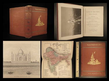
1872 INDIA Land of the Veda Travel Exploration Voyages Hindu Sepoy RebellionSchilb Antiquarian Rare Books4.8(421)See Sold PriceMar 31, 2024
Duval - Pair: Map of India & Map of MaldivesTrillium Antique Prints & Rare Books4.5(30)See Sold PriceFeb 24, 2024
Medicine.- Kennedy (James) The History of the Contagious Cholera, first edition, 1831 & others (11)Forum Auctions4.3(52)See Sold PriceFeb 29, 2024
INDIA WITHIN THE GANGES SUSAN GOLE ILLUSTRATED MAPS EARLY CARTOGRAPHYJasper524.5(9.8k)See Sold PriceFeb 27, 2024
New and Correct Map of North America With the West India Islands,Jasper524.5(9.8k)See Sold PriceFeb 27, 2024
1834 Malte-Brun Map of the Caribbean -- West India IslandsJasper524.5(9.8k)See Sold PriceFeb 27, 2024
WEST AFRICA Explorers' routes Senegal Ashanti. Mountains of Kong. SDUK 1857 mapJasper524.5(9.8k)See Sold PriceFeb 28, 2024
Afrique…Nord-Ouest' & 'Inde' by Meissas. N Africa India Singapore 1861 old mapJasper524.5(9.8k)See Sold PriceFeb 28, 2024
Blackie (Pub) 1882 Folio Map. West India Islands & Central AmericaAlbion Auctions4.6(336)See Sold PriceMar 01, 2024
1792 OLD INDIA HISTORY ANTIQUE ILLUSTRATED WITH MAPS OF THE EIGHTEENTH CENTURY IN FRENCHNY Elizabeth 4.3(84)See Sold PriceMar 03, 2024