ATLAS of ANTIENT GEOGRAPHY by SAMUEL BUTLER 1843John McInnis Auctioneers,LLC4.6(502)See Sold PriceFeb 24, 2024
18TH C. ANTIQUE MAP: FRENCH & INDIAN WAR, FRAMEDThomaston Place Auction Galleries4.4(386)See Sold PriceFeb 24, 2024
Rand McNally Railroad Map Cabinet w/ 21 Railroad MapsRail & Road Auctions4.6(165)See Sold PriceMar 08, 2024
Keith Haring - Ink on New York Map, Best Buddies, Inscribed, Signed, and DatedSapphire Auction GallerySee Sold PriceMar 02, 2024
LATE 17TH C. FRENCH MAP OF THE NEW WORLD BY ALEXIS-HUBERT JAILLOT (1632-1712)Thomaston Place Auction Galleries4.4(386)See Sold PriceFeb 24, 2024
Central Railroad of New Jersey Map of Sandy Hook Route-ca. 1903JM Hobby Supply and Railroad Artifact Auctions4.4(126)See Sold PriceFeb 24, 2024
Lot of Six Mixed Atlas Box Cars-HO Scale-New in BoxJM Hobby Supply and Railroad Artifact Auctions4.4(126)See Sold PriceFeb 25, 2024
Rand McNally/Santa Fe Railroad Map of Iowa-1912JM Hobby Supply and Railroad Artifact Auctions4.4(126)See Sold PriceFeb 24, 2024
NICOLAES VISSCHER (NETHERLANDS, 1618-1709) MAP OF THE NEW WORLDThomaston Place Auction Galleries4.4(386)See Sold PriceFeb 24, 2024
17TH C. WORLD MAP BY NICOLAES VISSCHER (NETHERLANDS, 1618-1709)Thomaston Place Auction Galleries4.4(386)See Sold PriceFeb 24, 2024
Lot of Six Mixed Atlas Cabooses-HO Scale-New in BoxJM Hobby Supply and Railroad Artifact Auctions4.4(126)See Sold PriceFeb 25, 2024
Sold1899 Map of JerusalemAuthor: Peerless Title: 1899 Map of Jerusalem Materials: Ink on Paper Dimensions: 13.5"X11" Description: Map of Jerusalem dated 1899. Part of the Peerless Atlas published the Crowelle an Kirkpatrick CSee Sold Price
SoldWright, Paul 1782 Holy Land Map. Jerusalem"A Correct Plan of the Antient City of Jerusalem" by Thomas Conder. Folio Copper Plate Published 1782, London for "The Complete British Family Bible…" by Paul Wright. Paper Size: 14.5 x 9.5 inch (37See Sold Price
SoldDated 1899 MapDated 1899 (Central School Supply House Chicago) topographical map. 34 1/4" x 47 1/2" Overall.See Sold Price
Sold1899 Map of LousianaAuthor: Matthews Title: 1899 Map of Lousiana Medium: Ink on Paper Dimensions: 13.5"X11" Map of Louisiana dated 1899. Published by the Matthews Northrup Co. in Buffalo. With extensive dated population,See Sold Price
Sold1899 Map of HawaiiTitle: 1899 Map of Hawaii Author: Miller Medium: Ink on Paper Dimensions: 16.5"X11" Description: Map of Hawaii dated 1898. Printed and published by J Martin Miller in Chicago. Key middle left. Inset oSee Sold Price
Sold1899 Map of Indian Reservations in the US -- MapTitle/Content of Map: 1899 Map of Indian Reservations in the US -- Map Showing Indian Reservations within the Limits of the United States Compiled under the Direction of W. A. Jones Comissioner of IndSee Sold Price
Sold1899 Map of Empires of China, Japan and KoreaAuthor: Miller Title: 1899 Map of Empires of China, Japan and Korea Medium: Ink on Paper Dimensions: 16"X11" Description: Map of the empires of China, Japan and Korea dated 1899. Published by J. MartiSee Sold Price
Sold1899 Map of the Empires of China, Japan and KoreaAuthor: Miller Title: 1899 Map of the Empires of China, Japan and Korea Medium: Ink on Paper Dimensions: 16.5"X11" Map of the empires of China, Japan and Korea dated 1899. Published by J. Martin MilleSee Sold Price
Sold1899 Map of OceaniaAuthor: Miller Title: 1899 Map of Oceania Medium: Ink on Paper Dimensions: 16.5"X11.5" Map of Oceania dated 1899. Published by J. Martin Miller and Company in Chicago. Very detailed full folio map. CaSee Sold Price
Sold1899 Map of West Indies and CubaAuthor: Matthews Title: 1899 Map of West Indies and Cuba Medium: Ink on Paper Dimensions: 13.5"X10.5" Map of West Indies and Cuba dated 1899. Published in Buffalo, New York by Matthews-Northrup. DetaiSee Sold Price
Sold1899 Map of British AmericaAuthor: Miller Title: 1899 Map of British America Medium: Ink on Paper Dimensions: 22.5"X16.5" Description: Map of British America, modern day Canada dated 1899. Published by J. Martin Miller and CompSee Sold Price
Sold1899 Map of ChicagoAuthor: Title: 1899 Map of Chicago Medium: Ink on Paper Dimensions: 12"X15" Description: Map of the city of Chicago dated 1899. Rather rare. Part of the 1899 in the National Standard Atlas of the WorlSee Sold Price
Sold1899 Map of the North PoleAuthor: Miller Title: 1899 Map of the North Pole Medium: Ink on Paper Dimensions: 16"X11" Description: Map of the empires of the North Pole dated 1899. Published by J. Martin Miller and Company in ChiSee Sold Price
Sold1899 Map of ColoradoAuthor: Cram Title: 1899 Map of Colorado Medium: Ink on Paper Dimensions: 13.5"X11" Map of Colorado dated 1899. Printed and published by George Cram in Chicago. Key lower left. Explanation on countiesSee Sold Price
SoldMAP - Jerusalem, Holy Land. DanckertsJerusalem, Holy Land. Cornelius Danckerts, De Stadt Ierusalem, 1718 (published). Hand Color. Great bird's-eye plan of the ancient holy city flanked by engravings of religious icons. At the bottom areSee Sold Price
1899 Map of EuropeAuthor: Miller Title: 1899 Map of Europe Medium: Ink on Paper Dimensions: 22.5"X16.5" Description: Map of Europe dated 1899. Published by J. Martin Miller and Company in Chicago. Very detailed elephanSee Sold Price
1899 Map of Cuba and the BahamasAuthor: Title: 1899 Map of Cuba and the Bahamas Medium: Ink on Paper Dimensions: 14.5"X12" Description: Map of Cuba and the Bahamas Islands dated 1899. Part of the 1899 in the National Standard AtlasSee Sold Price
Sold1899 Map of NashvilleTitle: 1899 Map of Nashville Author: Watson Medium: Ink on Paper Dimensions: 11.5"X14.5" Description: Map of the city of Nashville dated 1899. Printed and published by Watson in Chicago. Part of his WSee Sold Price
1899 Map of Cuba and the BahamasTitle: 1899 Map of Cuba and the Bahamas Medium: Ink on Paper Dimensions: 14.5"X12" Map of Cuba and the Bahamas Islands dated 1899. Rather rare. Part of the 1899 in the National Standard Atlas of the WSee Sold Price
1899 Map of ChicagoTitle: 1899 Map of Chicago Medium: Ink on Paper Dimensions: 12"X15" Map of the city of Chicago dated 1899. Rather rare. Part of the 1899 in the National Standard Atlas of the World. Published by the FSee Sold Price
1899 Map of IrelandTitle: 1899 Map of Ireland Medium: Ink on Paper Dimensions: 14.5"X22" Double folio map of Ireland dated 1899. Rather rare. Part of the 1899 in the National Standard Atlas of the World. Published by thSee Sold Price
1899 Map of ScotlandTitle: 1899 Map of Scotland Medium: Ink on Paper Dimensions: 14.5"X22" Double folio map of Scotland dated 1899. Rather rare. Part of the 1899 in the National Standard Atlas of the World. Published bySee Sold Price
SoldEARLY HANDCOLORED MAP (JERUSALEM ) MEASURES 16" X 20EARLY HANDCOLORED MAP (JERUSALEM ) MEASURES 16" X 20 1/2", FROM LOCAL ESTATE….See Sold Price
Sold1899 Map of the North PoleAuthor: Miller Title: 1899 Map of the North Pole Medium: Ink on Paper Dimensions: 16.5"X11.5" Map of the North Pole dated 1899. Published by J. Martin Miller and Company in Chicago. Very detailed map.See Sold Price
Cincinnati Hamilton and Dayton RR Map -USGC 1889JM Hobby Supply and Railroad Artifact Auctions4.4(126)See Sold PriceFeb 24, 2024
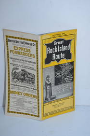
Chicago Rock Island and Pacific RY November 4, 1899 Public TimetableJM Hobby Supply and Railroad Artifact Auctions4.4(126)See Sold PriceFeb 24, 2024
Oregon Short Line RR April 1899 Public TimetableJM Hobby Supply and Railroad Artifact Auctions4.4(126)See Sold PriceFeb 24, 2024
Union Pacific RR July 1899 Public TimetableJM Hobby Supply and Railroad Artifact Auctions4.4(126)See Sold PriceFeb 24, 2024
Mishkenot Sha'ananim, Jerusalem - 19th Century PhotoLevy Auction House4.3(11)See Sold PriceFeb 27, 2024
Jerusalem Map for British Soldiers in Palestine - WW2Levy Auction House4.3(11)See Sold PriceFeb 27, 2024
Museum of Horrors - King of Pigs -Emil Zola - 1899Levy Auction House4.3(11)See Sold PriceFeb 27, 2024
[MAPS]. DUFOUR, Auguste-Henri (1795-1865). Bound Volume of ...Potter & Potter Auctions4.6(539)See Sold PriceMar 07, 2024
1738 BIBLE in DUTCH ILLUSTRATED w/ MAPS MASSIVE FOLIO in DUTCH antique BIBLIAJasper524.5(9.8k)See Sold PriceFeb 27, 2024
1738 BIBLE in DUTCH ILLUSTRATED w/ MAPS antique MASSIVE FOLIO BIBLIAJasper524.5(9.8k)See Sold PriceFeb 27, 2024
1730 BIBLE in DUTCH ILLUSTRATED w/ MAPS antique MASSIVE FOLIO BIBLIAJasper524.5(9.8k)See Sold PriceFeb 27, 2024
COLONIAL AFRICA. British East/Central/South Africa. Bechuanaland 1899 old mapJasper524.5(9.8k)See Sold PriceFeb 28, 2024
COLONIAL EAST AFRICA. German/British/Portuguese East Africa. Tanzania 1899 mapJasper524.5(9.8k)See Sold PriceFeb 28, 2024
Georg Bockler Map of Ancient Jerulsaem EtchingAuctions at Showplace4.5(726)See Sold PriceApr 07, 2024
Antoine Augustin Calmet (1672-1757) - Set of 6 Architecture Engraving - Temple of Jerusalem -Proverde Auctions4.3(3)See Sold PriceFeb 28, 2024


![[MAPS]. DUFOUR, Auguste-Henri (1795-1865). Bound Volume of ... (1 of 2)](https://p1.liveauctioneers.com/928/318880/171361279_1_x.jpg?height=282&quality=70&version=1707501302)


