ATLAS of ANTIENT GEOGRAPHY by SAMUEL BUTLER 1843John McInnis Auctioneers,LLC4.5(505)See Sold PriceFeb 24, 2024
18TH C. ANTIQUE MAP: FRENCH & INDIAN WAR, FRAMEDThomaston Place Auction Galleries4.4(393)See Sold PriceFeb 24, 2024
Rand McNally Railroad Map Cabinet w/ 21 Railroad MapsRail & Road Auctions4.6(165)See Sold PriceMar 08, 2024
Keith Haring - Ink on New York Map, Best Buddies, Inscribed, Signed, and DatedSapphire Auction Gallery4.1(67)See Sold PriceMar 02, 2024
LATE 17TH C. FRENCH MAP OF THE NEW WORLD BY ALEXIS-HUBERT JAILLOT (1632-1712)Thomaston Place Auction Galleries4.4(393)See Sold PriceFeb 24, 2024
Central Railroad of New Jersey Map of Sandy Hook Route-ca. 1903JM Hobby Supply and Railroad Artifact Auctions4.4(127)See Sold PriceFeb 24, 2024
Lot of Six Mixed Atlas Box Cars-HO Scale-New in BoxJM Hobby Supply and Railroad Artifact Auctions4.4(127)See Sold PriceFeb 25, 2024
Rand McNally/Santa Fe Railroad Map of Iowa-1912JM Hobby Supply and Railroad Artifact Auctions4.4(127)See Sold PriceFeb 24, 2024
NICOLAES VISSCHER (NETHERLANDS, 1618-1709) MAP OF THE NEW WORLDThomaston Place Auction Galleries4.4(393)See Sold PriceFeb 24, 2024
17TH C. WORLD MAP BY NICOLAES VISSCHER (NETHERLANDS, 1618-1709)Thomaston Place Auction Galleries4.4(393)See Sold PriceFeb 24, 2024
Lot of Six Mixed Atlas Cabooses-HO Scale-New in BoxJM Hobby Supply and Railroad Artifact Auctions4.4(127)See Sold PriceFeb 25, 2024
Sketch B Showing the Progress in Section No. 2Title/Content of Map: Sketch B Showing the Progress in Section No. 2 U.S.Coast Survey 1844 to 1850 [Long Island And New Jersey Shore] Cartographer: U.S. COAST SURVEY Date: 1851 Publisher: U.S. COAST SSee Sold Price
SoldU.S. Coast Survey 1853 Map of Long Island, New Jersey"Sketch B Showing the progress of Section No. 2" Electrotype Map Published 1843-65, Washington for "Report of the Superintendent of the U.S. Coast Survey..." Published under the supervision and directSee Sold Price
USCGS: Antique Survey Map of New England, 1889United States Coast and Geodetic survey sketch showing the progress of the survey in sections 1&2 Inset maps of St. Croix River and N.E. Boundary; sketch showing the progress of the survey in SectionSee Sold Price
Sold1873 CONNECTICUT & LONG ISLAND MAPUS Coast Survey, supervised by A.D. Bache Superintendent, Sketch B No. 2, Showing the Triangulation and Geographical in Section No. 2, from New York City to Point Judith, 1873.Dimensions: Frame H 23"See Sold Price
Maritime Chart, U.S. Coast Survey, San Diego To PtCHART. U.S. Coast Survey, Sketch showing the progress of the survey in Section no. X, (lower sheet), from San Diego to Pt. Sal, from 1850-1877, scale 600.000, 1877, good condition, folds, 29 1/2" T xSee Sold Price
Sketch B. No.2 Showing the Triangulation & GeographicalTitle/Content of Map: Sketch B. No.2 Showing the Triangulation & Geographical Positions in Section No.II From New York City to Point Judith Cartographer: U.S. COAST SURVEY Date: 1851 Publisher: U.S. CSee Sold Price
SoldFlorida Lithograph MapU.S. Coast Survey Sketch F Showing the Progress of the Survey in Section V. A.D. Bache (1806-1867). Lithographed map. Washington, D.C., 1855. 23 x 16 1/2 inches visible, 27 1/4 x 21 1/2 inches framedSee Sold Price
...Sketch F No.2 Showing the Progress of the Survey ofPublication Date: 1851 Title: ...Sketch F No.2 Showing the Progress of the Survey of Cedar Keys, Bahia Honda, Key Biscayne, Key West and Dry Tortugas in Section No. VI 1849-51 Cartographer: U.S. COASTSee Sold Price
...Sketch J No. 2 Showing Progress of the Survey On theTitle/Content of Map: ...Sketch J No. 2 Showing Progress of the Survey On the Western Coast of The United States Sections X & Xi Cartographer: U.S. COAST SURVEY Date: 1855 Publisher: U.S.C.S. Size: 29See Sold Price
SoldSketch C Showing the Progress of Section No.III fromPublication Date: 1861 Title: Sketch C Showing the Progress of Section No.III from 1843 to 1860 Cartographer: U.S. COAST SURVEY Publisher: GPO Height: 34.25 Width: 22.75 Triangulation of Chesapeake BaSee Sold Price
Sketch G Showing the Progress in Section No.9 [VicinityPublication Date: 1848 Title: Sketch G Showing the Progress in Section No.9 [Vicinity of Galveston] Cartographer: U.S. COAST SURVEY Publisher: U.S. C. S. Height: 9.75 Width: 7.6 Shows triangulation. RSee Sold Price
Sketch E Showing the Progress of Section No.V ...Title/Content of Map: Sketch E Showing the Progress of Section No.V ... 1847-51 Cartographer: U.S. COAST SURVEY Date: 1853 Publisher: U.S. COAST SURVEY Size: 11.1Height - 10.6Width "Reconnaissance ofSee Sold Price
Sketch F Showing the Progress of Section No.VI ... inTitle/Content of Map: Sketch F Showing the Progress of Section No.VI ... in 1849 Cartographer: U.S. COAST SURVEY Date: 1850 Publisher: U.S. COAST SURVEY Size: 11.75Height - 18.5Width "Reconnaissance oSee Sold Price
Sketch G Showing the Progress in Section No. 9Publication Date: 1848 Title: Sketch G Showing the Progress in Section No. 9 [Galveston Bay] Cartographer: U.S. COAST SURVEY Publisher: U.S. COAST SURVEY Height: 8.25 Width: 6 "U.S. Coast Survey in 18See Sold Price
Sketch I Showing the Progress in Section No.IX fromTitle/Content of Map: Sketch I Showing the Progress in Section No.IX from 1848 to 1871 Publication Date: 1875 Cartographer: U.S. COAST SURVEY Publisher: GPO Description: Shows triangulation from GalveSee Sold Price
Sketch D Showing the Progress of Section IV 1845 toTitle: Sketch D Showing the Progress of Section IV 1845 to 1855 [Cape Henry to Cape Fear] Publication Date: 1855 Cartographer: U.S. COAST SURVEY Publisher: U.S.C.S. Size: 34.25 x 24.75 TriangulationsSee Sold Price
Sketch H Showing the Progress of Section No.8.Title: Sketch H Showing the Progress of Section No.8. Publication Date: 1850 Cartographer: U.S. COAST SURVEY Publisher: U.S. C. S. [GULF COAST ALABAMA MISSISSIPPI] Height: 8.75 Width: 11.5 "from 1846See Sold Price
Sketch I Showing the Progress in Section No.9 [VicinityPublication Date: 1849 Title: Sketch I Showing the Progress in Section No.9 [Vicinity of Galveston] Cartographer: U.S. COAST SURVEY Publisher: U.S. C. S. Height: 9.75 Width: 8.6 Shows triangulation ofSee Sold Price
Sketch E Showing the Progress of Section No.V ... 1847Title: Sketch E Showing the Progress of Section No.V ... 1847 to 1860 Cartographer: U.S. Coast Survey Publisher: GPO Size: 22 X 35.5 Bull's Island to Savannah River, South Carolina and Georgia coast,See Sold Price
Sketch F Showing the Progress in Section No. VI (LowerTitle/Content of Map: Sketch F Showing the Progress in Section No. VI (Lower Sheet) from Cape Florida to Tortugas Islands Date: 1863 Cartographer: U.S. COAST SURVEY Size: 24 X 34 "from 1845 to 1863" TSee Sold Price
SoldSketch G Showing the Progress in Section No. 7 ...Title: Sketch G Showing the Progress in Section No. 7 ... Date: 1850 Cartographer: U.S. COAST SURVEY Publisher: U.S. COAST SURVEY Description: in the year 1849 reconnoissance of Pensacola and PerdidoSee Sold Price
Sketch C. Showing the Progress of Section No.3 U.S.Title: Sketch C. Showing the Progress of Section No.3 U.S. Coast Survey 1844 to 1850 [Chesapeake and Delaware Bays] Publication Date: 1850 Cartographer: U.S. COAST SURVEY Publisher: U.S. C. S. Height:See Sold Price
Sketch C. Showing the Progress of Section No.3 ... 1844Title/Content of Map: Sketch C. Showing the Progress of Section No.3 ... 1844 to 1850. Cartographer: U.S. COAST SURVEY Date: 1850 Publisher: U.S. COAST SURVEY Size: 21.75Height - 16Width Region aroundSee Sold Price
SoldSketch I Showing the Progress in Section No.Ix fromTitle: Sketch I Showing the Progress in Section No.Ix from 1848 to 1866 [Vicinity of Galveston] Cartographer: U.S. COAST SURVEY Publisher: GPO Size: 10 X 25 Shows triangulation of Galveston Bay. A litSee Sold Price
Proto-Sumerian Terracotta Tablet with Archaic TextTimeLine Auctions Ltd.4.6(183)See Sold PriceMar 05, 2024
Egyptian Classic Teardrop-Shaped Knapped HandaxeTimeLine Auctions Ltd.4.6(183)See Sold PriceMar 06, 2024
Hellenistic Rhodian Lead Slingshot with ScorpionTimeLine Auctions Ltd.4.6(183)See Sold PriceMar 07, 2024
Natural History - Large Petrified Fossil Tree Trunk SectionTimeLine Auctions Ltd.4.6(183)See Sold PriceMar 08, 2024
Natural History - Boxed Unpolished Fossil Tree Branch Section Group [8]TimeLine Auctions Ltd.4.6(183)See Sold PriceMar 08, 2024
Natural History - Very Large Fossil Orthoceras SculptureTimeLine Auctions Ltd.4.6(183)See Sold PriceMar 09, 2024
Natural History - Large Cut Agate Section Group [2].TimeLine Auctions Ltd.4.6(183)See Sold PriceMar 09, 2024
Natural History - Unpolished Fossil Tree Branch Section Group [10]TimeLine Auctions Ltd.4.6(183)See Sold PriceMar 09, 2024
Four Sets of Baltimore & Ohio Railroad China Centenary Hot Chocolate Blue Line Cups & SaucersRail & Road Auctions4.6(165)See Sold PriceMar 08, 2024
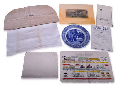
Mixed Group of Railroad Items - Baltimore & Ohio Railroad Menus, Sesquicentennial Plate, WabashRail & Road Auctions4.6(165)See Sold PriceMar 08, 2024
LOUIS VUITTON Hand Bag Speedy 30 Bandouliere Damier Azur Bag Added Insert A997Jasper524.5(9.9k)See Sold PriceFeb 28, 2024


![Natural History - Boxed Unpolished Fossil Tree Branch Section Group [8] (1 of 1)](https://p1.liveauctioneers.com/1191/317892/170615929_1_x.jpg?height=282&quality=70&version=1706617191)


![Natural History - Large Cut Agate Section Group [2]. (1 of 1)](https://p1.liveauctioneers.com/1191/317894/170617152_1_x.jpg?height=282&quality=70&version=1706620797)
![Natural History - Unpolished Fossil Tree Branch Section Group [10] (1 of 1)](https://p1.liveauctioneers.com/1191/317894/170617154_1_x.jpg?height=282&quality=70&version=1706620797)