ATLAS of ANTIENT GEOGRAPHY by SAMUEL BUTLER 1843John McInnis Auctioneers,LLC4.5(505)See Sold PriceFeb 24, 2024
18TH C. ANTIQUE MAP: FRENCH & INDIAN WAR, FRAMEDThomaston Place Auction Galleries4.4(393)See Sold PriceFeb 24, 2024
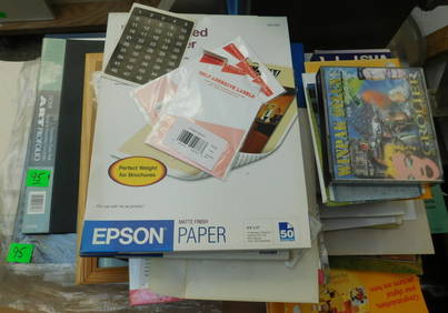
Rand McNally Railroad Map Cabinet w/ 21 Railroad MapsRail & Road Auctions4.6(165)See Sold PriceMar 08, 2024
Keith Haring - Ink on New York Map, Best Buddies, Inscribed, Signed, and DatedSapphire Auction Gallery4.1(67)See Sold PriceMar 02, 2024
LATE 17TH C. FRENCH MAP OF THE NEW WORLD BY ALEXIS-HUBERT JAILLOT (1632-1712)Thomaston Place Auction Galleries4.4(393)See Sold PriceFeb 24, 2024
Central Railroad of New Jersey Map of Sandy Hook Route-ca. 1903JM Hobby Supply and Railroad Artifact Auctions4.4(127)See Sold PriceFeb 24, 2024
Lot of Six Mixed Atlas Box Cars-HO Scale-New in BoxJM Hobby Supply and Railroad Artifact Auctions4.4(127)See Sold PriceFeb 25, 2024
Rand McNally/Santa Fe Railroad Map of Iowa-1912JM Hobby Supply and Railroad Artifact Auctions4.4(127)See Sold PriceFeb 24, 2024
NICOLAES VISSCHER (NETHERLANDS, 1618-1709) MAP OF THE NEW WORLDThomaston Place Auction Galleries4.4(393)See Sold PriceFeb 24, 2024
17TH C. WORLD MAP BY NICOLAES VISSCHER (NETHERLANDS, 1618-1709)Thomaston Place Auction Galleries4.4(393)See Sold PriceFeb 24, 2024
Lot of Six Mixed Atlas Cabooses-HO Scale-New in BoxJM Hobby Supply and Railroad Artifact Auctions4.4(127)See Sold PriceFeb 25, 2024
Sketch B. No.2 Showing the Triangulation & GeographicalTitle/Content of Map: Sketch B. No.2 Showing the Triangulation & Geographical Positions in Section No.II From New York City to Point Judith Cartographer: U.S. COAST SURVEY Date: 1851 Publisher: U.S. CSee Sold Price
Sold1873 CONNECTICUT & LONG ISLAND MAPUS Coast Survey, supervised by A.D. Bache Superintendent, Sketch B No. 2, Showing the Triangulation and Geographical in Section No. 2, from New York City to Point Judith, 1873.Dimensions: Frame H 23"See Sold Price
(B No.2) Sketch Showing the Progressive Changes in Sandy Hook from 1778 to 1850Title: (B No.2) Sketch Showing the Progressive Changes in Sandy Hook from 1778 to 1850 Date: 1850 Cartographer: U.S. COAST SURVEY Publisher: U.S. COAST SURVEY Description: compiled in the office of thSee Sold Price
... Sketch E No.2 Showing the Progress of the Survey at N. Edisto River and EntranceTitle: ... Sketch E No.2 Showing the Progress of the Survey at N. Edisto River and Entrance Date: 1850 Cartographer: U.S. COAST SURVEY Publisher: U.S. COAST SURVEY Description: Triangulation. Shore poSee Sold Price
Sketch B Showing the Progress in Section No. 2Title/Content of Map: Sketch B Showing the Progress in Section No. 2 U.S.Coast Survey 1844 to 1850 [Long Island And New Jersey Shore] Cartographer: U.S. COAST SURVEY Date: 1851 Publisher: U.S. COAST SSee Sold Price
(Sketch B No.2) ... Romer and Flynn's Shoals New YorkTitle/Content of Map: (Sketch B No.2) ... Romer and Flynn's Shoals New York Bay Date Printed: 1853 Cartographer: WOODHULL, M. Size: 14.3X12.1 Chart of the shoals and treacherous areas between Coney IsSee Sold Price
(Sketch B No.2) ... Romer and Flynn's Shoals New York BayTitle: (Sketch B No.2) ... Romer and Flynn's Shoals New York Bay Date: 1853 Cartographer: WOODHULL, M. Publisher: ROBERT ARMSTRONG Description: Chart of the shoals and treacherous areas between ConeySee Sold Price
SoldU.S. Coast Survey 1853 Map of Long Island, New Jersey"Sketch B Showing the progress of Section No. 2" Electrotype Map Published 1843-65, Washington for "Report of the Superintendent of the U.S. Coast Survey..." Published under the supervision and directSee Sold Price
SoldU S Coast Survey 1896 Large Map. Portland Canal, Alaska"Progress Sketch Showing Triangulation of Portland Canal and Vicinity. S. E. Alaska" Large Lithograph Map Published 1896, Washington for "U.S. Coast and Geodetic Survey" Folds as issued. Rare. Paper SSee Sold Price
U S Coast Survey 1896 Large Map. Portland Canal, Alaska"Progress Sketch Showing Triangulation of Portland Canal and Vicinity. S. E. Alaska" Large Lithograph Map Published 1896, Washington for "U.S. Coast and Geodetic Survey" Folds as issued. Rare. Paper SSee Sold Price
U S Coast Survey 1896 Large Map. Portland Canal, Alaska"Progress Sketch Showing Triangulation of Portland Canal and Vicinity. S. E. Alaska" Large Lithograph Map Published 1896, Washington for "U.S. Coast and Geodetic Survey" Folds as issued. Rare. Paper SSee Sold Price
U S Coast Survey 1896 Large Map. Portland Canal, Alaska"Progress Sketch Showing Triangulation of Portland Canal and Vicinity. S. E. Alaska" Large Lithograph Map Published 1896, Washington for "U.S. Coast and Geodetic Survey" Folds as issued. Rare. Paper SSee Sold Price
U S Coast Survey 1896 Large Map. Portland Canal, Alaska"Progress Sketch Showing Triangulation of Portland Canal and Vicinity. S. E. Alaska" Large Lithograph Map Published 1896, Washington for "U.S. Coast and Geodetic Survey" Folds as issued. Rare. Paper SSee Sold Price
U S Coast Survey 1896 Large Map. Portland Canal, Alaska"Progress Sketch Showing Triangulation of Portland Canal and Vicinity. S. E. Alaska" Large Lithograph Map Published 1896, Washington for "U.S. Coast and Geodetic Survey" Folds as issued. Rare. Paper SSee Sold Price
Sketch F No.2 Showing the Progress of the Survey of TheTitle/Content of Map: Sketch F No.2 Showing the Progress of the Survey of The Florida Reefs 1849 - 1855 Cartographer: U.S. Coast Survey Date: 1855 Publisher: U.S. Coast Survey/A.O.P. Nicholson Size: 1See Sold Price
Sketch F No.2 Showing the Progress of the Survey of TheTitle: Sketch F No.2 Showing the Progress of the Survey of The Florida Reefs 1849-1855 Publication Date: 1855 Cartographer: U.S. COAST SURVEY Publisher: U.S.C.S. Size: 17.75 x 14.25 Eight small sheetsSee Sold Price
...Sketch F No.2 Showing the Progress of the Survey ofPublication Date: 1851 Title: ...Sketch F No.2 Showing the Progress of the Survey of Cedar Keys, Bahia Honda, Key Biscayne, Key West and Dry Tortugas in Section No. VI 1849-51 Cartographer: U.S. COASTSee Sold Price
Sketch B (Bis) Sketch Showing Positions of the BuoysTitle: Sketch B (Bis) Sketch Showing Positions of the Buoys Placed in the Delaware Bay & River Under The Direction of The Superintendent U.S.C.S. ... Cartographer: GOLDSBOROUGH, J. R. Publication DateSee Sold Price
SoldU S Coast Survey 1896 Map. Delaware Bay, Salt Lake Utah"Sketch Showing Extension of Triangulation of Delaware Bay with sub-sketches of Salina and Salt Lake Bases" Large Lithograph Map Published 1896, Washington for "U.S. Coast and Geodetic Survey" Folds aSee Sold Price
Three US Coast Survey Map of Long Island RegionSketch B No. 3, showing the progressive changes in Sandy Hook from 1779 to 1853. Published Washington D.C. 1853, 12 x 11.5 inches. Folds as issued. Sketch B No 2. US Coast Survey of Romer and Flynns SSee Sold Price
Three US Coast Survey Map of Long Island RegionSketch B No. 3, showing the progressive changes in Sandy Hook from 1779 to 1853. Published Washington D.C. 1853, 12 x 11.5 inches. Folds as issued. Sketch B No 2. US Coast Survey of Romer and Flynns SSee Sold Price
US Coast Survey Map of New York Bay & Hudson RiverSketch B No. 3, showing the progressive of the survey in New York Bay and Hudson RIver from 1851 to 1859 Published Washington D.C. 1859, includes inset maps of "Hudson River from Albany to New BaltimoSee Sold Price
US Coast Survey Map of Sandy HookSketch B No. 3, showing the progressive changes in Sandy Hook from 1779 to 1853. Published Washington D.C. 1853, 12 x 11.5 inches. Folds as issued. Notice to bidders: Condition reports and additionalSee Sold Price
... Sketch A. Showing the Primary Triangulation inTitle: ... Sketch A. Showing the Primary Triangulation in Section No. I from 1844 to 1855 [Passamaquoddy Bay to Pt. Judith Light] Publication Date: 1855 Cartographer: U.S. COAST SURVEY Publisher: U.S.See Sold Price
5 Stephen Robin Framed Detailed SketchesB.S. Slosberg, Inc. Auctioneers4.5(381)See Sold PriceFeb 27, 2024
Lot Original Stephen Robin Artwork SketchesB.S. Slosberg, Inc. Auctioneers4.5(381)See Sold PriceFeb 27, 2024
Lot Original Stephen Robin Artwork SketchesB.S. Slosberg, Inc. Auctioneers4.5(381)See Sold PriceFeb 27, 2024
Large Group Art Sketch Books Portfolios, etc.B.S. Slosberg, Inc. Auctioneers4.5(381)See Sold PriceFeb 27, 2024
2 Stephen Robin Portfolios of ArtworkB.S. Slosberg, Inc. Auctioneers4.5(381)See Sold PriceFeb 27, 2024
Natural History - Fossil Hadrosaur Dinosaur EggTimeLine Auctions Ltd.4.6(183)See Sold PriceMar 05, 2024
Natural History - Large Petrified Fossil Tree Trunk SectionTimeLine Auctions Ltd.4.6(183)See Sold PriceMar 08, 2024
38 VAMPIRELLA Autograph, Sketch Art & Chase Cards/BSouth Florida Auction & Estate Sale Services Inc4.5(522)See Sold PriceMar 08, 2024
Frank Stella (American, b. 1936) - Marwla (Sketch)Freeman's | Hindman4.5(158)See Sold PriceFeb 27, 2024
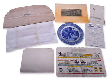
Mixed Group of Railroad Items - Baltimore & Ohio Railroad Menus, Sesquicentennial Plate, WabashRail & Road Auctions4.6(165)See Sold PriceMar 08, 2024
After Frank Lloyd Wright Dana Thomas House Arts & Crafts Mission Oak Dining or Breakfast Table, NewlLiberty & 33rd Furniture Co.4.4(13)See Sold PriceFeb 27, 2024
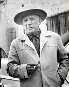
Pablo Picasso Signed 9x11.5 B&W Photo w/ Bull Sketch BAS #AI00150Mynt Auctions4.6(697)See Sold PriceFeb 24, 2024
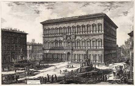
Piranesi Etching of Palazzo Farnese from Views of RomeConcept Art Gallery4.7(510)See Sold PriceMar 06, 2024
LIFAR SERGE: (1905-1986)International Autograph Auctions Europe S.L.4.4(52)See Sold PriceMar 13, 2024