ATLAS of ANTIENT GEOGRAPHY by SAMUEL BUTLER 1843John McInnis Auctioneers,LLC4.6(504)See Sold PriceFeb 24, 2024
18TH C. ANTIQUE MAP: FRENCH & INDIAN WAR, FRAMEDThomaston Place Auction Galleries4.4(389)See Sold PriceFeb 24, 2024
Rand McNally Railroad Map Cabinet w/ 21 Railroad MapsRail & Road Auctions4.6(165)See Sold PriceMar 08, 2024
Keith Haring - Ink on New York Map, Best Buddies, Inscribed, Signed, and DatedSapphire Auction Gallery4.1(67)See Sold PriceMar 02, 2024
LATE 17TH C. FRENCH MAP OF THE NEW WORLD BY ALEXIS-HUBERT JAILLOT (1632-1712)Thomaston Place Auction Galleries4.4(389)See Sold PriceFeb 24, 2024
Central Railroad of New Jersey Map of Sandy Hook Route-ca. 1903JM Hobby Supply and Railroad Artifact Auctions4.4(126)See Sold PriceFeb 24, 2024
Lot of Six Mixed Atlas Box Cars-HO Scale-New in BoxJM Hobby Supply and Railroad Artifact Auctions4.4(126)See Sold PriceFeb 25, 2024
Rand McNally/Santa Fe Railroad Map of Iowa-1912JM Hobby Supply and Railroad Artifact Auctions4.4(126)See Sold PriceFeb 24, 2024
NICOLAES VISSCHER (NETHERLANDS, 1618-1709) MAP OF THE NEW WORLDThomaston Place Auction Galleries4.4(389)See Sold PriceFeb 24, 2024
17TH C. WORLD MAP BY NICOLAES VISSCHER (NETHERLANDS, 1618-1709)Thomaston Place Auction Galleries4.4(389)See Sold PriceFeb 24, 2024
Lot of Six Mixed Atlas Cabooses-HO Scale-New in BoxJM Hobby Supply and Railroad Artifact Auctions4.4(126)See Sold PriceFeb 25, 2024
1671 Montanus Map of Very Early Virginia -- NovaTitle: 1671 Montanus Map of Very Early Virginia -- Nova Virginiae Tabula Cartographer: A. Montanus / J. Ogilby Date: 1671 c Size: 14.1 x 11.5 in. Additional Information: This is an outstanding decoratSee Sold Price
Sold1671 Montanus Map of Very Early Virginia -- NovaTitle/Content of Map: 1671 Montanus Map of Very Early Virginia -- Nova Virginiae Tabula Cartographer: A. Montanus / J. Ogilby Year/Place: 1671 c Size: 14.1 x 11.5 in. This is an outstanding decorativeSee Sold Price
1671 Montanus Map of Very Early Virginia -- NovaTitle: 1671 Montanus Map of Very Early Virginia -- Nova Virginiae Tabula Date: 1671 c Medium: A. Montanus / J. Ogilby Size: 14.1 x 11.5 in. Additional Information: This is an outstanding decorative maSee Sold Price
1671 Montanus Map of Very Early Virginia -- NovaTitle/Content of Map: 1671 Montanus Map of Very Early Virginia -- Nova Virginiae Tabula Date: 1671 c Cartographer: A. Montanus / J. Ogilby Size: 14.1 x 11.5 in. This is an outstanding decorative map oSee Sold Price
Soldc. 1671, Hand-Colored RARE MAP OF VIRGINIA NOVA VIRGINIAE TABULAHistoric Maps RARE MAP OF VIRGINIA: "NOVA VIRGINIAE TABUL" 1671, Beautiful Hand-Colored Map titled, "NOVA VIRGINIAE TABULA", by Cartographer John OGILBY, London, Choice Extremely Fine. A vibrant, decoSee Sold Price
Sold1671 Colored Map of Chesapeake Bay and VirginiaHistoric Maps Rare 1671 Hand-Colored Map of Chesapeake Bay and Virginia Titled “Nova Virginia Tabula” by John Ogilby (1671) Hand-Colored Engraved Map Titled, “Nova Virginia Tabula,” by John OgSee Sold Price
Sold1671 Colored Map of Chesapeake Bay and VirginiaHistoric Maps 1671 Hand-Colored Map of Chesapeake Bay and Virginia Titled “Nova Virginia Tabula” by John Ogilby, London (1671) Hand-Colored Engraved Map Titled, “Nova Virginia Tabula” by JohnSee Sold Price
Terrae- Mariae Virginiae Tabula, Ogilby & Montanus 1671Title: (Terrae- Mariae) Nova (et) Virginiae Tabula Subject: Virginia/ Maryland Maker: J. Ogilby and A. Montanus Date: 1671, Amsterdam Size: 11.4 x 13.8 inches Edition of Capt. John Smith's landmark maSee Sold Price
Sold1671 VIRGINIA AND THE CHESAPEAKE BAY REGION HAND-1671 VIRGINIA AND THE CHESAPEAKE BAY REGION HAND-COLORED MAP, "Nova Virginiae Tabula", John Ogilby and Arnoldus Montanus, three large cartouches, not framed. Second half 17th century. 11 3/4" x 14 1/4See Sold Price
Sold1633 NOVA VIRGINIAE TABULA, Map by HondiusHistoric MapsBeautiful 1633 Printed Hondius Map of Early Virginia c. 1633, Hand-Colored Map: "NOVA VIRGINIAE TABULA," by Hondius, Amsterdam, Very Fine. This impressive, decorative original copSee Sold Price
SoldMontanus Map of Virginia and Florida, 1671British, Virginiae Partis australis, et Floridae partis orientalis, by Arnoldus Montanus and John Ogilby, after the prototype by Willem Blaeu, black and white engraving with hand-colored highlights, tSee Sold Price
SoldArnoldus Montanus Map of Virginia and Florida(1625-1683), [Virginiae partis australis et Floridae partis orientalis]; 1671, black and white engraving with hand coloring, cartouches depicting Native Americans, 12 x 14 in.; unframed Provenance: CoSee Sold Price
SoldEarly Map of Virginia, Hand-colored engraved mapMapsEarly Map of Virginia “NOVA VIRGINIAE TABULA”, by Petrus Kaerius Caelavit, Choice Very Fine. Hand-colored copper engraved map, most likely clipped from a book or publication, 5.5&rdquoSee Sold Price
SoldMontanus 1671 Map of Mexico & Central AmericaDESCRIPTION: Map by cartographer Montanus extending to Costa Rica, based off cartographer Gerritsz's work. Title cartouche is bright and colorful reading "NOVA HISPANIA NOVA GALICIA GUATIMALA" and depSee Sold Price
SoldMap "Nova Virginia Tabula" 17th century.Hand Colored map, by Willem Janszoon Blaeu. Amsterdam C. 1640, hand colored. Plate size 18.75" x 14 5/8", visible plate bite beyond those measurements. A very important and early map of the United StaSee Sold Price
SoldNova Virginae Tabula (sic), hand-colored mapcirca 1631; copper engraved hand-colored early map of Virginia by Pieter van den Keere and Jan Jansson, 5 x 7 1/2 in. in eglomise silver wood frameSee Sold Price
SoldHand-Colored Map titled, “NOVA VIRGINIAE TABULA”Historic Maps Circa 1629 Willem Blaeu’s “NOVA VIRGINIAE TABULA” Beautiful Hand-Colored Early Virginia Framed Map c. 1629, Hand-Colored Map titled, “NOVA VIRGINIAE TABULA” by “BLAEU, W.”See Sold Price
SoldEarly Map of Virginia afterJohn White [Nova Virginiae Tabula], by Willem Blaeu, Amsterdam, circa 1640, engraved after Jodocus Hondius' derivation of John White's 1612 map of Virginia, intricately detailed map of the ChesapeakeSee Sold Price
SoldArnoldus Montanus Map of Southeastern CoastArnoldus Montanus Map of Southeastern Coast"Virginiae partis australis et Floridae partis orientalis...Nova Descriptio," Amsterdam, 1671, a hand-colored double-page copperplate engraving showing VirgiSee Sold Price
SoldNova Virginiae Tabula. [C. early 1630's - 1660's].[Virginia]. Nova Virginiae Tabula. Double-page map of the Chesapeake Bay, its tributaries, and surrounding area. Vignette at upper left is a sinister scene where Chief Powhattan is seated in front ofSee Sold Price
SoldNova Virginia Tabula. [1671 or later].[Virginia] NOVA VIRGINIAE TABULA. Derived from the Hondius-Blaeu version of John Smith’s map. Oriented to the West. Tooley’s Derivative 8, State 1: Cartouche at upper left with no imprint. “NotaSee Sold Price
Soldc 1650 Color Map, NOVA VIRGINIAE TABULA, MontanusHistoric Maps "NOVA VIRGINIAE TABULA" by Arnoldus Montanus c. 1650, Early Hand-Colored Map of America titled, "NOVA VIRGINIAE TABULA", by Arnoldus Montanus, after John Smith's Map, Choice Very Fine. TSee Sold Price
SoldGroup of Two Maps of Virginia and North CarolinaGroup of Two Works,A. After Arnoldus Montanus (Dutch c. 1625-1683),Nova Terrae-Mariae Tabula,Engraving with hand-coloring depicting Virginia and Maryland from John Ogilby's America, inscribed Ogilby,See Sold Price
SoldVenezuela, Arnoldus Montanus 1671Title: Venezuela cum parte Australi Novae Andalusiae Subject: Venezuela Maker: Arnoldus Montanus Date: 1671, Amsterdam Size: 11.4 x 14.25 inches From Montanus' "De Nieuwe en Onbekende Weereld: of BescSee Sold Price
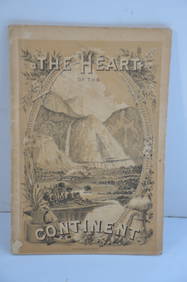
Chicago Burlington and Quincy RR The Heart of the Continent Book-1882JM Hobby Supply and Railroad Artifact Auctions4.4(126)See Sold PriceFeb 24, 2024
LARGE GULF SERVICE STATION MAP COLLECTION WITH DISPLAY STAND.Dan Morphy Auctions4.2(1.3k)See Sold PriceFeb 24, 2024
EARLY 18TH C. DUTCH CHART OF PACIFIC OCEAN BY FREDERIK DE WIT (1629-1706) WITH CALIFORNIA AS ANThomaston Place Auction Galleries4.4(389)See Sold PriceFeb 24, 2024
EARLY 18TH C. MAP OF ITALY, FRAMEDThomaston Place Auction Galleries4.4(389)See Sold PriceFeb 24, 2024
Nova Totius Full Color Geographical World MapThe Benefit Shop Foundation Inc.4.3(2.9k)See Sold PriceFeb 28, 2024
An early Dutch hand colored engraving map by Georg Balthasar Probst (1732-1801)Ostantix Auctions4.4(10)See Sold PriceFeb 27, 2024
Pair of Early Railroad Maps - 1874 Delaware, Lackawanna & Western and 1876 Pennsylvania RailroadRail & Road Auctions4.6(165)See Sold PriceMar 07, 2024
Pair of Early Railroad Maps - 1862 Pittsburgh, Ft. Wayne & Chicago Railway and 1873 PennsylvaniaRail & Road Auctions4.6(165)See Sold PriceMar 07, 2024
Early 1990s Chicago Transit Authority Fiberglass Line MapRail & Road Auctions4.6(165)See Sold PriceMar 08, 2024
INDIA WITHIN THE GANGES SUSAN GOLE ILLUSTRATED MAPS EARLY CARTOGRAPHYJasper524.5(9.8k)See Sold PriceFeb 27, 2024
WEST AFRICA Explorers' routes Senegal Ashanti. Mountains of Kong. SDUK 1857 mapJasper524.5(9.8k)See Sold PriceFeb 28, 2024
THE ANTIQUE ILLUSTRATED BOOK "1856 ARCTIC EXPLORATIONS: SECOND GIRNEL EXPEDITION 2" BY E. KANENY Elizabeth 4.3(85)See Sold PriceMar 03, 2024


![Nova Virginiae Tabula. [C. early 1630's - 1660's]. (1 of 10)](https://p1.liveauctioneers.com/179/47316/21802645_1_x.jpg?height=282&quality=70&version=1383851649)
![Nova Virginia Tabula. [1671 or later]. (1 of 6)](https://p1.liveauctioneers.com/179/93063/47518642_1_x.jpg?height=282&quality=70&version=1472482862)