ATLAS of ANTIENT GEOGRAPHY by SAMUEL BUTLER 1843John McInnis Auctioneers,LLC4.5(505)See Sold PriceFeb 24, 2024
18TH C. ANTIQUE MAP: FRENCH & INDIAN WAR, FRAMEDThomaston Place Auction Galleries4.4(393)See Sold PriceFeb 24, 2024
Rand McNally Railroad Map Cabinet w/ 21 Railroad MapsRail & Road Auctions4.6(165)See Sold PriceMar 08, 2024
Keith Haring - Ink on New York Map, Best Buddies, Inscribed, Signed, and DatedSapphire Auction Gallery4.1(67)See Sold PriceMar 02, 2024
LATE 17TH C. FRENCH MAP OF THE NEW WORLD BY ALEXIS-HUBERT JAILLOT (1632-1712)Thomaston Place Auction Galleries4.4(393)See Sold PriceFeb 24, 2024
Central Railroad of New Jersey Map of Sandy Hook Route-ca. 1903JM Hobby Supply and Railroad Artifact Auctions4.4(127)See Sold PriceFeb 24, 2024
Lot of Six Mixed Atlas Box Cars-HO Scale-New in BoxJM Hobby Supply and Railroad Artifact Auctions4.4(127)See Sold PriceFeb 25, 2024
Rand McNally/Santa Fe Railroad Map of Iowa-1912JM Hobby Supply and Railroad Artifact Auctions4.4(127)See Sold PriceFeb 24, 2024
NICOLAES VISSCHER (NETHERLANDS, 1618-1709) MAP OF THE NEW WORLDThomaston Place Auction Galleries4.4(393)See Sold PriceFeb 24, 2024
17TH C. WORLD MAP BY NICOLAES VISSCHER (NETHERLANDS, 1618-1709)Thomaston Place Auction Galleries4.4(393)See Sold PriceFeb 24, 2024
Lot of Six Mixed Atlas Cabooses-HO Scale-New in BoxJM Hobby Supply and Railroad Artifact Auctions4.4(127)See Sold PriceFeb 25, 2024
Soldc 1650 Color Map, NOVA VIRGINIAE TABULA, MontanusHistoric Maps "NOVA VIRGINIAE TABULA" by Arnoldus Montanus c. 1650, Early Hand-Colored Map of America titled, "NOVA VIRGINIAE TABULA", by Arnoldus Montanus, after John Smith's Map, Choice Very Fine. TSee Sold Price
Hondius Map of Virginia, 1630HONDIUS, Henricus (1573 –1650), after John Smith (1580-1631). Nova Virginiae Tabula. Engraving with original hand color. Amsterdam, c. 1630. 19” x 23” sheet, 24” x 27 3/4&rdquSee Sold Price
SoldBlaeu Map of Virginia, 1640BLAEU, Willem Janszoon (1571-1638). Nova Virginiae Tabula. Engraved map with original color in full. Amsterdam, c. 1640. 20" x 23" sheet. This Map by Hondius was the first version of Smith's map of thSee Sold Price
Blaeu Map of VirginiaBLAEU, Willem Janszoon (1571-1638). Nova Virginiae Tabula. Engraved map with original hand color. Amsterdam: Blaeu, c. 1640. 20 x 23 3/8 inches sheetSee Sold Price
1671 Montanus Map of Very Early Virginia -- NovaTitle: 1671 Montanus Map of Very Early Virginia -- Nova Virginiae Tabula Cartographer: A. Montanus / J. Ogilby Date: 1671 c Size: 14.1 x 11.5 in. Additional Information: This is an outstanding decoratSee Sold Price
SoldBlaeu Map of VirginiaNova Virginiae Tabula. William Blaeu (1571-1638). Engraved Map with original hand color. Amsterdam, c. 1640. 18 x 22 1/4 inches sheet.See Sold Price
SoldNova Virginiae TabulaHenricus Hondius (1573-1650). Engraved map with original hand color in full. Amsterdam, 1640. 20 x 23 1/2 inches sheet, 29 1/2 x 32 3/4 inches framed. This Map by Hondius was the first version of SmitSee Sold Price
1671 Montanus Map of Very Early Virginia -- NovaTitle: 1671 Montanus Map of Very Early Virginia -- Nova Virginiae Tabula Date: 1671 c Medium: A. Montanus / J. Ogilby Size: 14.1 x 11.5 in. Additional Information: This is an outstanding decorative maSee Sold Price
SoldMontanus - Nova Virginiae Tabula, Hand ColoredArnoldus Montanus (circa 1625-1683), and Jacob van Meurs; Nova Virginiae Tabula, 1671, black and white line engraving with hand color on laid paper, 11-1/2 x 14-1/8 in (plate), 12-1/4 x 14-3/4 in. (ovSee Sold Price
SoldDanckerts, Novi BelgiiDANCKERTS, Justus (1635-1701). Novi Belgii Novae Que Angliae Nec Non Pennsylvaniae et Partis Virginiae Tabula. Engraving with original hand color. Amsterdam: c. 1684. Dimensions. Comparables: StockholSee Sold Price
SoldColor engraved map of Virginia Nova Virginiae Tabulacolor engraved map of Virginia {Nova Virginae Tabula} by Henricus Hondius Amsterdam, 1631, based on John Smith's map of 1612. DOA 17.25 x 22 in.See Sold Price
Sold1633 NOVA VIRGINIAE TABULA, Map by HondiusHistoric MapsBeautiful 1633 Printed Hondius Map of Early Virginia c. 1633, Hand-Colored Map: "NOVA VIRGINIAE TABULA," by Hondius, Amsterdam, Very Fine. This impressive, decorative original copSee Sold Price
SoldNova Virginiae Tabula. Map. C. 1630-1663.[Virginia]. Nova Virginiae Tabula. Double-page map of the Chesapeake and its surroundings, oriented to the West. "Taken from the first state of the Smith [map of Virginia], it continues the coastlinesSee Sold Price
Sold1671 VIRGINIA AND THE CHESAPEAKE BAY REGION HAND-1671 VIRGINIA AND THE CHESAPEAKE BAY REGION HAND-COLORED MAP, "Nova Virginiae Tabula", John Ogilby and Arnoldus Montanus, three large cartouches, not framed. Second half 17th century. 11 3/4" x 14 1/4See Sold Price
SoldHand-Colored Map titled, “NOVA VIRGINIAE TABULA”Historic Maps Circa 1629 Willem Blaeu’s “NOVA VIRGINIAE TABULA” Beautiful Hand-Colored Early Virginia Framed Map c. 1629, Hand-Colored Map titled, “NOVA VIRGINIAE TABULA” by “BLAEU, W.”See Sold Price
Soldc. 1671, Hand-Colored RARE MAP OF VIRGINIA NOVA VIRGINIAE TABULAHistoric Maps RARE MAP OF VIRGINIA: "NOVA VIRGINIAE TABUL" 1671, Beautiful Hand-Colored Map titled, "NOVA VIRGINIAE TABULA", by Cartographer John OGILBY, London, Choice Extremely Fine. A vibrant, decoSee Sold Price
SoldHondius Map of VirginiaHONDIUS, Henricus (1597-1651).Nova Virginiae Tabula.Engraved map with original hand color in full.Amsterdam, 1633-38 (German Text).18 3/4" x 23" sheet.The present is derived from John Smith's 1612 mapSee Sold Price
Sold17th Century Map of the Southeast[Nova Virginiae Tabula], by Arnoldus Montanus or John Ogilby, Amsterdam/London, 1671 (published the same year in two different atlases), based on the Hondius-Blaeu version of John Smith's 1612 map ofSee Sold Price
SoldVisscher Map of N.E. U.S., 1655VISSCHER, Nicolas (1618-1679). Novi Belgii Novaeque Angliae nec non Virginiae Tabula... Engraved map with original hand color. Amsterdam, c. 1655 (State 2, 1656). 20 1/2" x 24 3/4" sheet, 31" x 35" frSee Sold Price
MAP - Mid-Atlantic US. HondiusColonial Mid-Atlantic United States. Hondius/Schenk & Valck, Nova Virginiae Tabula, 1700 (circa). Hand Color. This graphic map is Henricus Hondius' version of Capt. John Smith's important map of 1612,See Sold Price
SoldOrtelius Map of AfricaOrtelius, Abraham (1527-1598). Africa Tabula Nova. Engraved map with original hand color. Antwerp, c. 1570-1588. 21 ½" x 17 ⅛" sheet, 33 ½" x 29 ¼" framed. A magnificent early map of ASee Sold Price
Visscher View of Novi BelgiiVISSCHER, Nicholaes (1618-1679). Novi Belgii Novawque Angliae nec non virginiae Tabula... Engraved map with original hand color. Amsterdam, c. 1684 (State 4, Burden 315). 20 1/2" x 24 1/4" sheet, 31"See Sold Price
SoldMontanus - Nova Virginiae TabulaArnoldus Montanus (circa 1625-1683) and Jacob van Meurs, Nova Virginiae Tabula, 1671, black and white engraving, 11-1/2 x 14-1/8 in. (plate), 12-1/4 x 14-1/2 in. (overall); unframed Notes: This copy oSee Sold Price
MAP, Mid-Atlantic US, JanssonColonial Mid-Atlantic United States. Jan Jansson, Nova Virginiae Tabula, 1630 (published). Hand Color. This delicately engraved map is a reduced version of John Smith's map of the Chesapeake Bay regioSee Sold Price
17TH C. WORLD MAP BY NICOLAES VISSCHER (NETHERLANDS, 1618-1709)Thomaston Place Auction Galleries4.4(393)See Sold PriceFeb 24, 2024
LATE 17TH C. FRENCH MAP OF THE NEW WORLD BY ALEXIS-HUBERT JAILLOT (1632-1712)Thomaston Place Auction Galleries4.4(393)See Sold PriceFeb 24, 2024
Nova Totius Full Color Geographical World MapThe Benefit Shop Foundation Inc.4.3(2.9k)See Sold PriceFeb 28, 2024
Willem Blaeu, Etc. 17th C. Antiquarian Maps, 2Auctions at Showplace4.6(740)See Sold PriceMar 17, 2024
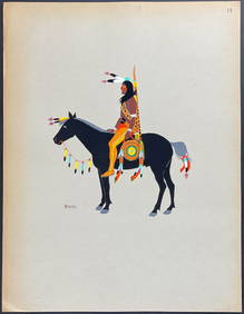
Kiowa Indian Art - Mopope: Kiowa Warrior on HorsebackTrillium Antique Prints & Rare Books4.5(32)See Sold PriceFeb 24, 2024
Kiowa Indian Art - Mopope: Kiowa Warrior and wifeTrillium Antique Prints & Rare Books4.5(32)See Sold PriceFeb 24, 2024
3 Vintage The World Lithographs, By JanssonThe Benefit Shop Foundation Inc.4.3(2.9k)See Sold PriceMar 13, 2024