Sold18TH C. MAP OF JERUSALEM, UNFRAMED"A New Plan of Old Jerusalem, According to the Author", 1732, by Antoine Augustin Calmet (1672-1757), Leide, hand colored copperplate engraving, on wove paper, unframed, in mat, 13" x 17" image. VerySee Sold Price
Sold18th C Map Ancient World JerusalemEngraved plate showing maps of ancient world including inset of Judea and Samaria and one of Jerusalem. Early 18th century.Very Good, trimmed to plate lines, measures 7 x 5.5". Reserve: $20.00 ShippinSee Sold Price
SoldGroup of late 18th c./early 19th c. unframed maps incl.Group of late 18th c./early 19th c. unframed maps incl. some by Strahan & Cadell, J. Gibson, T. AikenSee Sold Price
SoldFive unframed engraved maps of Europe, 18th c., tFive unframed engraved maps of Europe, 18th c., together with an unframed later map of Turkey, a map of Steuben County, New York, and a framed map of Gascogne.See Sold Price
SoldJ.B. Homann, 18th c. map of SaxonyJ.B. Homann, 18th c. map of Saxony, Johann Baptist Homann (German,1664-1724), "Circulus Saxoniae inferioris", c. 1740, including Bremen, Berlin, and Lübeck, 20.75"h x 24.5"w (sheet), unframed ProveSee Sold Price
SoldAn 18th C Tinted Map of BavariaAn 18th C Tinted Map of Bavaria copy of a 15th C map. Unframed, 14" h, 17 1/2" w.See Sold Price
18TH C. MAPS OF W. INDIES ISLANDS, 218TH C. MAPS OF W. INDIES ISLANDS, 2, ONE BY S. BELLIN, 18" X 25" - 23" X 25":All hand colored and unframed. S. Bellin, map of St. Lucia, No. 80, 1763, signed, c. 23" x 25 1/4" plate and paper; Map diSee Sold Price
Sold18THC MAP OF SCOTLAND, P. SANTINI, 20" X 28 1/2",18THC MAP OF SCOTLAND, P. SANTINI, 20" X 28 1/2", DATED 1778, MINOR TEARS AT EDGES, WATER MARK MIDDLE LEFT, UNFRAMED.See Sold Price
SoldCalmet, Augustin, 1672-1757,Map of Nazareth18th C. Map, titled, "Afbeelding van de Stad Nazareth" View of Nazareth, Unframed, 16.5 x 21.5 inches Calmet, Augustin, Book titled, "Overall great historical, judicious, chronological,See Sold Price
Sold17/18THC MAP OF BELGIUM, HAND COLORED, FREDERICK17/18THC MAP OF BELGIUM, HAND COLORED, FREDERICK DE WIT, 19 1/2" X 23 1/4", MINOR CREASES AT CORNERS, VERTICAL CRESE WITH SLIGHT TEAR, UNFRAMED.See Sold Price
SoldVAUGONDY ENGRAVING MAP CHARLEMAGNE EMPIRE, 18TH C.Unframed map, engraving on paper, "Imperium Caroli Magni Occidentis Imperatoris," Didier Robert de Vaugondy (French, 1723-1786), cartouche with title in upper left corner, held aloft by winged putti,See Sold Price
Sold18thC. French map of CanadaLate 18th C. engraved French map of Canada, hand tinted on laid paper, shows the Great Lakes, 14-7/8" x 10" h., from a map of the New World, 1778, M. Bonne. CONDITION: Unframed. In an archival mat. VeSee Sold Price
Sold18th C. War Map, Waterway Titled "Scaldis Flu".Early 18th Century War Map with Waterway Titled "Scaldis Flu". Image size 9-1/4" x 12", framed and matted, 16" x 19 overall. Along with another unframed map with banner "TERRAE SANCT AE TABVLA", 7-1/2See Sold Price
SoldHOMANN ENGRAVING MAP MOROCCO NORTH AFRICA, 18TH C.Unframed map, engraving on paper, "Statuum Marocca Norum," Johann Christoph Homann (German, 1703-1730), cartouche with title in upper left corner, showing Morocco, the Canary Islands, inset map of theSee Sold Price
JOHANN MATTHIAS HASE ENGRAVING MAP AFRICA, 18TH C.Unframed map, engraving on paper, "'Africa Secundum Legitimas Projectionis Stereographicae regulas," Johann Matthias Hase (German, 1684-1742), cartouche with title in lower left corner, illustrated wiSee Sold Price
Sold18THC GERMAN MAP OF ASIA, HAND COLORED,DATED 179518THC GERMAN MAP OF ASIA, HAND COLORED, DATED 1795, FRANZ JOH.JOS. VON REILLY, 27" X 35", MINOR TEARS AT EDGES & CREASE LINE VERTICALLY THROUGH CENTER, UNFRAMED.See Sold Price
*D'ANVILLE(Mid 18th C. Italian) "Gallia Antiqua Romani and Monuments", unframed 2-sheet engraved map with later handcoloring, dated 1760 upper left plate, approximate plate size 18" x 23", total paper size 22 1See Sold Price
SoldGroup of Seventeen Double Sheet Atlas Maps of Europe,Group of Seventeen Double Sheet Atlas Maps of Europe, 18th c., by Robert de Vaugondy, unframed, Each- H.- 22 in., W.- 30 1/2 in.See Sold Price
SoldGroup of Fifteen Double Sheet Atlas Maps of Europe, 18tGroup of Fifteen Double Sheet Atlas Maps of Europe, 18th c., by Robert de Vaugondy, unframed, Each- H.- 22 in., W.- 30 1/2 in.See Sold Price
Sold*LIEBAUX, JEAN BAPTISTE(Mid 18th C. French) "Tabula Italia Antique", unframed and unmounted 2-piece engraved map for Guillermo Delisle, printed by Phillippe Buache, artist name and dated 1745 upper right plate, approximateSee Sold Price
Sold25 Maps, Europe, P. G. Chanlaire(lot of 25) Unframed handcolored maps, Various European Locales, c. 1790, by Pierre Gregoire Chanlaire (French, 18th Century), plate sizes vary, sheets approximately: 23''h x 32.5''w. Note: Some mapsSee Sold Price
25 Maps, Europe, P. G. Chanlaire(lot of 25) Unframed handcolored maps, Various European Locales, c. 1790, by Pierre Gregoire Chanlaire (French, 18th Century), plate sizes vary, sheets approximately: 23''h x 32.5''w. Note: Some mapsSee Sold Price
SoldHomann Heirs, map England and WalesHomann Heirs, map England and Wales, Homann Heirs (18th c.), "Regni Angliae et Principatus Cambriae Tabula Nova", c. 1793, 24.25"h x 20.5"w (sheet), unframed Provenance: Property from a major corporatSee Sold Price
EMANUEL BOWEN, MAP, ST. KITTS, 14" X 17"EMANUEL BOWEN, MAP, ST. KITTS, 14" X 17", 18TH C.:Island of St. Kitts (St. Christopher) and Bermuda; black and white, signed, not dated, 14 1/8" x 17 1/8", 19" x 22 7/8" paper; center fold; unframed.See Sold Price
EARLY 18TH C. DUTCH CHART OF PACIFIC OCEAN BY FREDERIK DE WIT (1629-1706) WITH CALIFORNIA AS ANThomaston Place Auction Galleries4.4(393)See Sold PriceFeb 24, 2024
EARLY 18TH C. MAP OF ITALY, FRAMEDThomaston Place Auction Galleries4.4(393)See Sold PriceFeb 24, 2024
18TH C. ANTIQUE MAP: FRENCH & INDIAN WAR, FRAMEDThomaston Place Auction Galleries4.4(393)See Sold PriceFeb 24, 2024
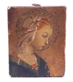
18TH C. FLORENTINE MINIATURE OF THE MADONNAThomaston Place Auction Galleries4.4(393)See Sold PriceFeb 24, 2024
LOT OF 9 ANTOINE DE MARCENAY ETCHINGS 18th C.Marnie Collection Auction4.5(70)See Sold PriceMar 10, 2024
Two (2) Antique 18th C. Copper Engraved Framed Maps - America & EuropeMagnusson Art Group4.5(53)See Sold PriceMar 14, 2024
Map: An 18thC engraved and hand coloured map of Buckinghamshire after Robert Morden. Approx. 8 1/4"Claydon Auctioneers Ltd4.3(125)See Sold PriceFeb 26, 2024
Map: An 18thC engraved and hand coloured map of Northamptonshire, with description ofClaydon Auctioneers Ltd4.3(125)See Sold PriceFeb 26, 2024
Map: An 18thC engraved and hand coloured map of North America and South America, titled DeClaydon Auctioneers Ltd4.3(125)See Sold PriceFeb 26, 2024
Map: An 18thC engraved map of Bedfordshire titled An Accurate Map of the County of Bedford DividedClaydon Auctioneers Ltd4.3(125)See Sold PriceFeb 26, 2024
Map: An 18thC engraved map titled A New and Improved Map of Oxfordshire.. after Thomas Kitchin.Claydon Auctioneers Ltd4.3(125)See Sold PriceFeb 26, 2024
French School, "Lovers with Basket of Eggs," and "Lovers with Songbirds," 18th c., H.- 32 in., W.-Crescent City Auction Gallery4.3(231)See Sold PriceMar 09, 2024