Claude Monet French 1840 - 1926 Oil on canvas Painting Impressionism Renoir Manet Pissarro Era.International Art Auction Gallery4.4(163)See Sold PriceFeb 24, 2024
Antique American Hudson River School Sunset Landscape Framed Original Oil PaintingCurated Gallery Auctions4.6(131)See Sold PriceFeb 25, 2024
Robert William Wood (1889 - 1979) Texas BluebonnetsPremier Auction Galleries4.4(331)See Sold PriceMar 09, 2024
BIRGER SANDZEN (1871-1954) COLORADO OIL ON CANVAS 1936Soulis Auctions4.8(953)See Sold PriceFeb 24, 2024
Vincent Van Gogh Dutch 1853-1890 Oil on canvas. Paul Gaugin, Cezanne, Degas EraInternational Art Auction Gallery4.4(163)See Sold PriceFeb 24, 2024
Renaissance Old Master Altarpiece Adoration Magi Oil Painting Christ Child Virgin Mary Wise MenHess Fine Auctions4.5(210)See Sold PriceMar 02, 2024
19TH C GERMAN OIL PAINTING BY EMIL ZSCHIMMER C 1872Antique Arena Inc.4.5(878)See Sold PriceFeb 24, 2024
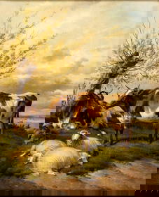
JOHN CONSTABLE ANTIQUE ENGLISH CLOUDS OIL PAINTINGAntique Arena Inc.4.5(878)See Sold PriceFeb 24, 2024
ATTRIBUTED TO GILBERT STUART (MA/RI/UK, 1755-1828)Thomaston Place Auction Galleries4.4(393)See Sold PriceFeb 24, 2024
Pablo Picasso Spanish 1881-1973 Oil On Canvas Painting Dali Magritte Braque Juan GrisInternational Art Auction Gallery4.4(163)See Sold PriceFeb 24, 2024
ATTRIB Francisco Miralles Y Galup (Spain,France,1848-1901) oil painting antiqueBroward Auction Gallery4.7(292)See Sold PriceMar 10, 2024
AMERICAN SCHOOL (Early 20th c) Two WorksJohn McInnis Auctioneers,LLC4.5(505)See Sold PriceFeb 25, 2024
Thomas Sidney Cooper (UK,1803-1902) oil painting antiqueBroward Auction Gallery4.7(292)See Sold PriceMar 10, 2024
JOHANN MATTHIAS HASE ENGRAVING MAP AFRICA, 18TH C.Unframed map, engraving on paper, "'Africa Secundum Legitimas Projectionis Stereographicae regulas," Johann Matthias Hase (German, 1684-1742), cartouche with title in lower left corner, illustrated wiSee Sold Price
SoldTWO EARLY MAPS. Map of Africa by Johann Matthias HTWO EARLY MAPS. Map of Africa by Johann Matthias Hase (German, 1684-1742), engraving on laid paper with handcoloring, 18th Century, 24"h. 27"w. (framed); and a map of Greece and Crete by Guillaume DelSee Sold Price
SoldHOMANN ENGRAVING MAP MOROCCO NORTH AFRICA, 18TH C.Unframed map, engraving on paper, "Statuum Marocca Norum," Johann Christoph Homann (German, 1703-1730), cartouche with title in upper left corner, showing Morocco, the Canary Islands, inset map of theSee Sold Price
SoldAfricaJohann Matthias Hase (1684-1742). engraved map with original hand-color in full. Nuremberg, c. 1740. 21 x 24 inches, 32 1/2 x 35 1/2 inches framed. Map of Africa by the first cartographer to use a sciSee Sold Price
Sold[Map of Russian Empire and Tartary]. Imperii Russici Et[Map of Russian Empire and Tartary]. Imperii Russici Et Tatariae Universal. Johann Matthias Hase. Nuremberg, 1739. - 54x62 cm. Engraving. Painted with watercolor. Decorative cartouche with dedicationSee Sold Price
SoldFramed Antique 18th C R Reynolds Map of AfricaFramed Antique 18th C R Reynolds Map of Africa. Antique 18th century hand colored engraving. With certificate in envelope on back. Measures 13.5 x 16.75 inches.See Sold Price
SoldAN ANTIQUE MAP, "Americæ Mappa Generalis," 1746,AN ANTIQUE MAP, "Americæ Mappa Generalis," 1746, hand colored engraving, published by Johann Baptist Homann (1664-1724) with special acknowledgement to Johann Matthias Hase (1684-1742) and AugustSee Sold Price
SoldJohann Gabriel Doppelmayr (1677-1750), "HemisphaeriumJohann Gabriel Doppelmayr (1677-1750), "Hemisphaerium Coeli Australe," 18th c., hand colored celestial map copper engraving published by Johan Baptiste Homann, Nuremburg, framed, H.- 20 5/8 in., W.- 2See Sold Price
SoldAN ANTIQUE MAP, "Americæ Mappa Generalis," 1746,AN ANTIQUE MAP, "Americæ Mappa Generalis," 1746, hand colored engraving, published by Johann Baptist Homann (1664-1724) with special acknowledgement to Johann Matthias Hase (1684-1742) and AugustSee Sold Price
SoldHistorical map of Russia, Johann Matthias Hase,Historical map of Russia, Johann Matthias Hase, ''Imperii Russici'', map of Russia at the time of Empress Anna (1730-1740), partial col. Copper engraving with two allegorical cartridges, at Homann's hSee Sold Price
Antique Colored Map - Europe - Balkans - Hungary - Romania - Bulgaria - HeirsOriginally colored engraved map of the Balkans by Johann Matthias Hase printed by Homann Heirs. Shows Hungary, Romania, Bulgaria, the former Yugoslavia (Croatia, Serbia, Bosnia, Macedonia), Albania anSee Sold Price
SoldFour 18th c. German Maps, European CountriesMAPS. Reilly, Franz Johann Joseph von (Vienna 1766-1820) Group of 4 colored engravings, maps of Europe including Scotland, Frankreich, Ireland, and Italy, possibly from Schauplatz der funf Theile derSee Sold Price
Sold18TH C MAP, NORTH AMERICA, UNITED STATES & MEXICOJohann Baptist Homann (German, 1664-1724). "Regni Mexicani seu Novae Hispaniae" - circa 1725, engraving with hand coloring. Approx. 20.75" x 24" (sheet) Item from the Estate of Forest "Tag" Hunter, AtSee Sold Price
SoldRARE 18TH C. MAP OF THE AMERICASHomann Heirs / Johann Matthaus Haas: "Americae Mappa generalis Secundum legimitas projectionis Stereiographiae regulas . . . MDCCXXXXVI". Nuremberg, 1746. Copperplate engraving on laid paper with handSee Sold Price
SoldJohann Christoph Muller, 18th C. Map of BohemiaJohann Christoph Muller (Austrian, 1673-1721), "Mappa Totius Regni Bohemiae", hand colored engraving on paper. Circa 1742, Covens and Mortier edition of Muller's map depicting an early accurate map ofSee Sold Price
Sold18th C. Hand Colored Map of Moravia Pub. by Homann"Tabula Generalis Marchionatus Moraviae in Sex Circulos Divisa" published by Johann Baptiste Homann after Johann Christoph Muller's cartography, circa 1720. Hand colored engraving of a map with figureSee Sold Price
Sold2 maps. Inc: Afrique. Atlas Methodique. 1761.[Africa] 2 maps. (1) Claude Buy de Mornas (French, 18th c.). "Afrique." 1761-1762. Hand-colored copper plate engraving, flanked by text panels in French. From "Atlas methodique et elementaire de ge´oSee Sold Price
SoldTwo historical maps of the 18th century, Germany andTwo historical maps of the 18th century, Germany and Denmark, ''Imperium Romano-Germanicum ...'' (Central Germany). Copper engraving, Matthias Seutter c. 1730, ''Regni Daniae ...'', copperplate engravSee Sold Price
Sold18th C. Schreiber Maps incl. California as Island.18th C. Schreiber Maps incl. California as Island. circa 1750, nicely handcolored, matted, and framed; includes the World Atlas, America; Asia; Europe; and Africa. Note: Johann Georg Schreiber, a GermSee Sold Price
18th C. Schreiber Maps incl. California as Island. (5)18th C. Schreiber Maps; circa 1750, nicely handcolored, matted, and framed; includes the World Atlas, America; Asia; Europe; and Africa. Note: Johann Georg Schreiber, a German cartographer and geograSee Sold Price
Three maps of Africa - Maps, MapsMatthäus Seutter (1678-1757), AFRICA, copper engraving, handcoloured, published by Tobias Lotter, Augsburg, ca. 1740, 22 cm x 28 cm (8.6 x 11 in); Johann C.G. Schreibern (1676-1750), AFRICA, copper eSee Sold Price
Three maps of Africa - MapsMatthäus Seutter (1678-1757), AFRICA, copper engraving, handcoloured, published by Tobias Lotter, Augsburg, ca. 1740, 22 cm x 28 cm (8.6 x 11 in); Johann C.G. Schreibern (1676-1750), AFRICA, copper eSee Sold Price
Homann, J.B. Africa Secundum Legitimas ProjectionisHomann, Johann Baptist Africa Secundum Legitimas Projectionis Stereograficae regulas C. 1737 Copperplate engraving; coloured Sheet size: 50 x 53 cm; 19.7 x 20.9 in A coloured map of the continent of ASee Sold Price
SoldMid-18th Century Map by Heirs of Johann HomannDominia Anglorum in America Septentrionale… Homann Heirs (18th century). Copper-plate engraving with original hand color in part. Nuremberg: Homann, c. 1745. 20 1/2 x 23 inches sheet. In the mid-18tSee Sold Price
LATE 18TH C. VERY LARGE CHART OF NORTHEAST CANADA BY DES BARRES (1721-1824), 1780, FRAMEDThomaston Place Auction Galleries4.4(393)See Sold PriceFeb 24, 2024
EARLY 18TH C. DUTCH CHART OF PACIFIC OCEAN BY FREDERIK DE WIT (1629-1706) WITH CALIFORNIA AS ANThomaston Place Auction Galleries4.4(393)See Sold PriceFeb 24, 2024
LARGE EARLY 18TH C. DUTCH CHART OF UPPER NORTH AMERICA, PIERRE MORTIER (1661-1711), FRAMEDThomaston Place Auction Galleries4.4(393)See Sold PriceFeb 24, 2024
EARLY 18TH C. MAP OF ITALY, FRAMEDThomaston Place Auction Galleries4.4(393)See Sold PriceFeb 24, 2024
18TH C. ANTIQUE MAP: FRENCH & INDIAN WAR, FRAMEDThomaston Place Auction Galleries4.4(393)See Sold PriceFeb 24, 2024
An early Dutch hand colored engraving map by Georg Balthasar Probst (1732-1801)Ostantix Auctions4.4(11)See Sold PriceFeb 27, 2024
AFTER ANGELICA KAUFMANN, 18TH CENTURY A pair of monochrome stipple engravings, 39 x 33cm, GiltAdam's Auctioneers4.3(5)See Sold PriceFeb 27, 2024
Johann Homann Hand-Colored Map Engraving, c. 1730Auctions at Showplace4.6(740)See Sold PriceMar 17, 2024
Two (2) Antique 18th C. Copper Engraved Framed Maps - America & EuropeMagnusson Art Group4.5(53)See Sold PriceMar 14, 2024
Carey, pub. 1796 - Map of the Tennassee State formerly part of North Carolina (Tennessee)Trillium Antique Prints & Rare Books4.5(32)See Sold PriceFeb 24, 2024
GEORGE II 18TH C. SAMUEL WOOD STERLING CRUET.William Smith Auctions4.6(147)See Sold PriceMar 06, 2024


![[Map of Russian Empire and Tartary]. Imperii Russici Et (1 of 2)](https://p1.liveauctioneers.com/6171/172047/86669617_1_x.jpg?height=282&quality=70&version=1593095278)