ATLAS of ANTIENT GEOGRAPHY by SAMUEL BUTLER 1843John McInnis Auctioneers,LLC4.5(505)See Sold PriceFeb 24, 2024
18TH C. ANTIQUE MAP: FRENCH & INDIAN WAR, FRAMEDThomaston Place Auction Galleries4.4(393)See Sold PriceFeb 24, 2024
Rand McNally Railroad Map Cabinet w/ 21 Railroad MapsRail & Road Auctions4.6(165)See Sold PriceMar 08, 2024
Keith Haring - Ink on New York Map, Best Buddies, Inscribed, Signed, and DatedSapphire Auction Gallery4.1(67)See Sold PriceMar 02, 2024
LATE 17TH C. FRENCH MAP OF THE NEW WORLD BY ALEXIS-HUBERT JAILLOT (1632-1712)Thomaston Place Auction Galleries4.4(393)See Sold PriceFeb 24, 2024
Central Railroad of New Jersey Map of Sandy Hook Route-ca. 1903JM Hobby Supply and Railroad Artifact Auctions4.4(127)See Sold PriceFeb 24, 2024
Lot of Six Mixed Atlas Box Cars-HO Scale-New in BoxJM Hobby Supply and Railroad Artifact Auctions4.4(127)See Sold PriceFeb 25, 2024
Rand McNally/Santa Fe Railroad Map of Iowa-1912JM Hobby Supply and Railroad Artifact Auctions4.4(127)See Sold PriceFeb 24, 2024
NICOLAES VISSCHER (NETHERLANDS, 1618-1709) MAP OF THE NEW WORLDThomaston Place Auction Galleries4.4(393)See Sold PriceFeb 24, 2024
17TH C. WORLD MAP BY NICOLAES VISSCHER (NETHERLANDS, 1618-1709)Thomaston Place Auction Galleries4.4(393)See Sold PriceFeb 24, 2024
Lot of Six Mixed Atlas Cabooses-HO Scale-New in BoxJM Hobby Supply and Railroad Artifact Auctions4.4(127)See Sold PriceFeb 25, 2024
SoldAN ANTIQUE MAP, "Map to Illustrate the Route of PrinceAN ANTIQUE MAP, "Map to Illustrate the Route of Prince Maximilian of Wied in the Interior of North America from Boston to the upper Missouri & al. 1832, 1833, &1834," 1839-1841, hand colored engravingSee Sold Price
SoldMap of Maximilian's travels in 1830s U.S.Title: Map to Illustrate the Route of Prince Maximilian of Wied in the Interior of North America [title also in French and German] Author: Maximilian, Alexander Philipp, Prince of Wied Description: PSee Sold Price
SoldMAP -- MAXIMILIAN zu Wied-Neuwied; Prince; and KarMAP -- MAXIMILIAN zu Wied-Neuwied; Prince; and Karl BODMER. Map to Illustrate the Route of Prince Maximilian of Wied in the Interior of North America.N.p.: n.d. [but Coblenz: 1839-41?]. DoublSee Sold Price
SoldTwo Maps: The Missouri River Basin and MassachusetTwo Maps: The Missouri River Basin and Massachusetts, a "Map to illustrate the route of Prince Maximilian of Wied in the interior of North America From Boston to the Upper Missouri in 1832, 33, & 34,"See Sold Price
SoldAN ANTIQUE MAP, "Map of Texas to Illustrate Olney'sAN ANTIQUE MAP, "Map of Texas to Illustrate Olney's School Geography," hand colored engraving. 11" x 8.50"See Sold Price
SoldMaximilin travels the U.S.Heading: Author: Maximilian of Wied, Prince Title: Map to illustrate the Route of Prince Maximilian of Wied in the interior of North America From Boston to the Upper Missouri &c. in 1832, 33, 34 [titSee Sold Price
SoldAN ANTIQUE POSTAL MAP, "Post Route Map of the State ofAN ANTIQUE POSTAL MAP, "Post Route Map of the State of Texas with adjacent parts of Louisiana, Arkansas, Indian Territory, and the Republic of Mexico," CIRCA 1878, hand colored lithograph on paper, "DSee Sold Price
Hughes: Antique Map of Route of Xenophon, 1856Map: Route of Xenophon and the Ten Thousand Greeks Date: 1856 By William Hughes from Long's Classical Atlas. Includes: Troja, Thermopylae, Marathon, Plataea, Mantinea, Granicus, Leuctra, Issus, ArbelaSee Sold Price
SoldWilkinson: Map of Route of Alexander the Great, 18071807 map showing the route of Alexander the Great. Pub. by R. Wilkinson. 8.625 x 11.25. Detailed and attractive map showing the route of Alexander the Great. A beautiful and original antique map. ColoSee Sold Price
Antique Map of Proposed Pacific Railroad Routes, 1850sTitle: 1850s Map of Proposed Pacific Railroad Routes -- Map of the Central Portion of the United States Showing the Lines of the Proposed Pacific Railroads Cartographer: Pacific Railroad Year / Place:See Sold Price
Ettling: Antique Map of USA South, 1863TITLE/CONTENT OF MAP: 'United States of North America South West sheet' USA SOUTH. Texas New Mexico. Gadsden purchase shown as Arizona The map shows routes "Proposed for the Pacific Railroad". The easSee Sold Price
SoldRare Circus Map ANTIQUE BARNUM & BAILEY CIRCUS TOUR OFDetails: Rare Circus Map ANTIQUE BARNUM & BAILEY CIRCUS TOUR OF THE UK ORIGINAL ROUTE MAP 1897-1898 Collectible Circus Ephemera England Decorative This lot features an original antique map from the BSee Sold Price
Thomson: Antique Map of Abyssinia, Ethiopia 1817TITLE/CONTENT OF MAP: 'Abyssinia' The map shows the routes of Henry Salt and Nathaniel Pearce, the Portuguese embassy of 1520, the route of the Ras's army in 1809, and Caravan routes DATE PRINTED: 181See Sold Price
Antique Map Print - America - Map of Newfoundland - Cape Breton Island - BellinCarte du Golphe de St. Laurent et Pays Voisins. (Newfoundland, Cape Breton Island, Prince Edward Island). Engraved map from the Dutch edition of Bellin's Histoire General des Voyages. Original hand-coSee Sold Price
SDUK: Antique Map of La Plata & Chile, 1846Title/Content of Map: 'SOUTH AMERICA, SHEET IV., LA PLATA AND CHILÉ' The map shows the routes of South American explorers & pioneers including Charles Darwin 1833, French 1826, Villarino 1782, GeneraSee Sold Price
SDUK: Antique Map of La Plata & Chile, 1846Title/Content of Map: 'SOUTH AMERICA, SHEET IV., LA PLATA AND CHILÉ' The map shows the routes of South American explorers & pioneers including Charles Darwin 1833, French 1826, Villarino 1782, GeneraSee Sold Price
SDUK: Antique Map of La Plata and Chile, 1844Title/Content of Map: 'SOUTH AMERICA, SHEET IV., LA PLATA AND CHILÉ' The map shows the routes of South American explorers & pioneers including Charles Darwin 1833, General Pachecho 1833, General de lSee Sold Price
Buchon: Antique Map of Mississippi, 1825TITLE/CONTENT OF MAP: 'Carte géographique, statistique et historique du Mississippi' The map indicates the routes of Wilkinson, General Jackson (from New Orleans to Muscle Shoals) and Indian tracks.See Sold Price
Sold[LIVINGSTON, David] Lot of 2 items sold together[LIVINGSTON, David] Lot of 2 items sold together, including: Arrowsmith, J. "Map to Illustrate Dr.Livingstone's Route across Africa Constructed from his Astronomical Observations, Bearings, EstimatedSee Sold Price
SoldMitchell: Antique Map of Southern States, US, 1858MAP of SOUTHERN STATES & PART WESTERN U.S. NC SC GA FL AL TN LA AK MS. Circa 1858 Antique Map. No. 12 - MAP OF THE CHIEF PART OF THE SOUTHERN STATES AND PART OF THE WESTERN. Engraved to Illustrate MitSee Sold Price
Antique Map of Early New England Railroad Plans, 1831Map: Antique Map of the Very Early New England Railroad Plans -- Map Exhibiting the Several Routes Surveyed for a Proposed Rail Road from Boston to Providence and also to Taunton Cartographer: W. G. MSee Sold Price
Routes of Explorers in the Western Pamir. Central Asia. Sketch map 1885TITLE/CONTENT OF MAP: 'Routes of Explorers in the Western Pamir' DATE PRINTED: 1885 IMAGE SIZE: Approx 16.0 x 11.0cm, 6.25 x 4.25 inches (Small) TYPE: Antique engraved sketch map CONDITION: Good; suitSee Sold Price
Explorers' routes in the Aralo-Caspian Basin. Kazakhstan. Sketch map 1885TITLE/CONTENT OF MAP: 'Routes of the Explorers in the Aralo-Caspian Basin' DATE PRINTED: 1885 IMAGE SIZE: Approx 13.5 x 8.0cm, 5.25 x 3.25 inches (Small) TYPE: Antique engraved sketch map CONDITION: GSee Sold Price
SoldAntique Map of the Exodus RouteMap: Voyage des Infans d'Israel d'Egypt par la Mer Rouge jusques au Pays de Canaan Cartographer: Philippe de la Rue / Covens & Mortier Place & Date: Amsterdam / 1730 Size: 18 1/2" x 15 5/8" Condition:See Sold Price
NORTHERN AFRICA. Morocco Tunisia Algeria. Caravan routes. RAPKIN/TALLIS 1851 mapJasper524.5(9.9k)See Sold PriceFeb 28, 2024
WEST AFRICA Explorers' routes Senegal Ashanti. Mountains of Kong. SDUK 1857 mapJasper524.5(9.9k)See Sold PriceFeb 28, 2024
Pre-colonial Africa. Mountains of Kong/Moon. Caravan routes. THOMSON 1817 mapJasper524.5(9.9k)See Sold PriceFeb 28, 2024
WEST AFRICA I Explorers' routes Senegal Ashanti Ivory Gold Coast. SDUK 1851 mapJasper524.5(9.9k)See Sold PriceFeb 28, 2024
WEST AFRICA II. NIGERIA. Bight of Benin-Lake Chad. Yariba Houssa. SDUK 1851 mapJasper524.5(9.9k)See Sold PriceFeb 28, 2024
AFRICA. Shows Mountains of Kong/the Moon. Caravan routes. RAPKIN/TALLIS 1851 mapJasper524.5(9.9k)See Sold PriceFeb 28, 2024
NIGERIA early explorers' routes. Lake Chad. Yariba Houssa Borgou SDUK 1844 mapJasper524.5(9.9k)See Sold PriceFeb 28, 2024
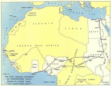
West Africa WW2 Nigeria Sudan Egypt. Takoradi air reinforcement route 1954 mapJasper524.5(9.9k)See Sold PriceFeb 28, 2024
NIGERIA w/ early explorers' routes. Lake Chad Yariba Houssa Borgou.SDUK 1844 mapJasper524.5(9.9k)See Sold PriceFeb 28, 2024
West Africa. Sahara caravan routes. Tribes Kingdoms Empires. LIZARS 1842 mapJasper524.5(9.9k)See Sold PriceFeb 28, 2024
WEST AFRICA showing early explorers' routes & Mountains of Kong. SDUK 1844 mapJasper524.5(9.9k)See Sold PriceFeb 28, 2024
NORTHERN AFRICA. Morocco Tunisia Algeria. Caravan routes. RAPKIN/TALLIS 1851 mapJasper524.5(9.9k)See Sold PriceFeb 28, 2024


![[LIVINGSTON, David] Lot of 2 items sold together (1 of 2)](https://p1.liveauctioneers.com/1124/187577/94368873_1_x.jpg?height=282&quality=70&version=1607095126)