ATLAS of ANTIENT GEOGRAPHY by SAMUEL BUTLER 1843John McInnis Auctioneers,LLC4.5(505)See Sold PriceFeb 24, 2024
18TH C. ANTIQUE MAP: FRENCH & INDIAN WAR, FRAMEDThomaston Place Auction Galleries4.4(394)See Sold PriceFeb 24, 2024
Rand McNally Railroad Map Cabinet w/ 21 Railroad MapsRail & Road Auctions4.6(165)See Sold PriceMar 08, 2024
Keith Haring - Ink on New York Map, Best Buddies, Inscribed, Signed, and DatedSapphire Auction Gallery4.1(67)See Sold PriceMar 02, 2024
LATE 17TH C. FRENCH MAP OF THE NEW WORLD BY ALEXIS-HUBERT JAILLOT (1632-1712)Thomaston Place Auction Galleries4.4(394)See Sold PriceFeb 24, 2024
Central Railroad of New Jersey Map of Sandy Hook Route-ca. 1903JM Hobby Supply and Railroad Artifact Auctions4.4(127)See Sold PriceFeb 24, 2024
Lot of Six Mixed Atlas Box Cars-HO Scale-New in BoxJM Hobby Supply and Railroad Artifact Auctions4.4(127)See Sold PriceFeb 25, 2024
Rand McNally/Santa Fe Railroad Map of Iowa-1912JM Hobby Supply and Railroad Artifact Auctions4.4(127)See Sold PriceFeb 24, 2024
NICOLAES VISSCHER (NETHERLANDS, 1618-1709) MAP OF THE NEW WORLDThomaston Place Auction Galleries4.4(394)See Sold PriceFeb 24, 2024
17TH C. WORLD MAP BY NICOLAES VISSCHER (NETHERLANDS, 1618-1709)Thomaston Place Auction Galleries4.4(394)See Sold PriceFeb 24, 2024
Lot of Six Mixed Atlas Cabooses-HO Scale-New in BoxJM Hobby Supply and Railroad Artifact Auctions4.4(127)See Sold PriceFeb 25, 2024
Routes of Explorers in the Western Pamir. Central Asia. Sketch map 1885TITLE/CONTENT OF MAP: 'Routes of Explorers in the Western Pamir' DATE PRINTED: 1885 IMAGE SIZE: Approx 16.0 x 11.0cm, 6.25 x 4.25 inches (Small) TYPE: Antique engraved sketch map CONDITION: Good; suitSee Sold Price
Chief Itineraries of Central Asia. Silk route. Explorers trade. Sketch map 1885TITLE/CONTENT OF MAP: 'Chief Itineraries of Central Asia' DATE PRINTED: 1885 IMAGE SIZE: Approx 11.5 x 12.0cm, 4.5 x 4.75 inches (Small) TYPE: Antique engraved sketch map CONDITION: Good; suitable forSee Sold Price
Projected Railway Lines in Western Asia. Sketch map 1885 old antique chartTITLE/CONTENT OF MAP: 'Projected Railway Lines in Western Asia' DATE PRINTED: 1885 IMAGE SIZE: Approx 10.5 x 11.0cm, 4 x 4.5 inches (Small) TYPE: Antique engraved sketch map CONDITION: Good; suitableSee Sold Price
H'wen-Tsang. Xuanzang itinerary. India Afghanistan Central Asia. Sketch map 1885TITLE/CONTENT OF MAP: 'Itinerary of H'wen-Tsang' DATE PRINTED: 1885 IMAGE SIZE: Approx 11.5 x 12.0cm, 4.5 x 4.75 inches (Small) TYPE: Antique engraved sketch map CONDITION: Good; suitable for framing.See Sold Price
Chief Religions of Asia. Shamanists Pagans Islam Buddhists. Sketch map 1885TITLE/CONTENT OF MAP: 'Chief Religions of Central Asia' DATE PRINTED: 1885 IMAGE SIZE: Approx 12.5 x 12.0cm, 4.75 x 4.75 inches (Small) TYPE: Antique engraved sketch map CONDITION: Good; suitable forSee Sold Price
Central Asia Plateaux & Plains. Hindu Kush Tian Shan Himalayas. Sketch map 1885TITLE/CONTENT OF MAP: 'Plateaux and Plains of Central Asia' DATE PRINTED: 1885 IMAGE SIZE: Approx 9.5 x 12.0cm, 3.75 x 4.75 inches (Small) TYPE: Antique engraved sketch map CONDITION: Good; suitable fSee Sold Price
Explorers' routes in the Aralo-Caspian Basin. Kazakhstan. Sketch map 1885TITLE/CONTENT OF MAP: 'Routes of the Explorers in the Aralo-Caspian Basin' DATE PRINTED: 1885 IMAGE SIZE: Approx 13.5 x 8.0cm, 5.25 x 3.25 inches (Small) TYPE: Antique engraved sketch map CONDITION: GSee Sold Price
Sold* BURNABY, Frederick Gustavus (1842-1885). A Ride to* BURNABY, Frederick Gustavus (1842-1885). A Ride to Khiva: Travels and Adventures in Central Asia. London: Cassell, Petter & Galpin, n.d. [1876]. 8vo. Color-printed folding frontispiece route map andSee Sold Price
Comparative Population of India and Indo-China. South Asia. Sketch map 1885TITLE/CONTENT OF MAP: 'Comparative Population of India and Indo-China' DATE PRINTED: 1885 IMAGE SIZE: Approx 13.0 x 11.5cm, 5 x 4.5 inches (Small) TYPE: Antique engraved sketch map CONDITION: Good; suSee Sold Price
Arid Regions and Closed River Basins of Asia. Sketch map 1885 old antiqueTITLE/CONTENT OF MAP: 'Arid Regions and Closed Basins of Asia' DATE PRINTED: 1885 IMAGE SIZE: Approx 12.0 x 12.0cm, 4.75 x 4.75 inches (Small) TYPE: Antique engraved sketch map CONDITION: Good; suitabSee Sold Price
The Religions of India. South Asia. Sketch map 1885 old antique plan chartTITLE/CONTENT OF MAP: 'The Religions of India' DATE PRINTED: 1885 IMAGE SIZE: Approx 16.5 x 12.0cm, 6.5 x 4.75 inches (Small) TYPE: Antique engraved sketch map CONDITION: Good; suitable for framing. PSee Sold Price
Encroachments of Asiatic Russia on China. East Asia. Sketch map 1885 oldTITLE/CONTENT OF MAP: 'Encroachments of Asiatic Russia on China' DATE PRINTED: 1885 IMAGE SIZE: Approx 11.5 x 11.5cm, 4.5 x 4.5 inches (Small) TYPE: Antique engraved sketch map CONDITION: Good; suitabSee Sold Price
Linguistic Families of India. South Asia. Sketch map 1885 old antiqueTITLE/CONTENT OF MAP: 'Linguistic Families of India' DATE PRINTED: 1885 IMAGE SIZE: Approx 15.0 x 11.5cm, 6 x 4.5 inches (Small) TYPE: Antique engraved sketch map CONDITION: Good; suitable for framingSee Sold Price
Isobars in July. Asia. Sketch map 1885 old antique vintage plan chartTITLE/CONTENT OF MAP: 'Isobars in July' DATE PRINTED: 1885 IMAGE SIZE: Approx 10.5 x 11.5cm, 4.25 x 4.5 inches (Small) TYPE: Antique engraved sketch map CONDITION: Good; suitable for framing. Please cSee Sold Price
Range of Animal Species in North Asia. Sketch map 1885 old antique chartTITLE/CONTENT OF MAP: 'Range of Animal Species in North Asia' DATE PRINTED: 1885 IMAGE SIZE: Approx 12.5 x 12.5cm, 5 x 5 inches (Small) TYPE: Antique engraved sketch map CONDITION: Good; suitable forSee Sold Price
Isobars in January. Asia. Sketch map 1885 old antique vintage plan chartTITLE/CONTENT OF MAP: 'Isobars in January' DATE PRINTED: 1885 IMAGE SIZE: Approx 11.0 x 12.0cm, 4.25 x 4.5 inches (Small) TYPE: Antique engraved sketch map CONDITION: Good; suitable for framing. PleasSee Sold Price
Projected Indo-European Railways. Asia. Sketch map 1885 old antique chartTITLE/CONTENT OF MAP: 'Projected Indo-European Railways' DATE PRINTED: 1885 IMAGE SIZE: Approx 7.5 x 11.0cm, 3 x 4.25 inches (Small) TYPE: Antique engraved sketch map CONDITION: Good; suitable for fraSee Sold Price
Middle East ethnic divisions. South west Asia. Sketch map 1885 old antiqueTITLE/CONTENT OF MAP: 'Ethnical Divisions of Hither Asia' DATE PRINTED: 1885 IMAGE SIZE: Approx 12.0 x 11.0cm, 4.75 x 4.5 inches (Small) TYPE: Antique engraved sketch map CONDITION: Good; suitable forSee Sold Price
Lake Khanka / Xingkai. East Asia. Sketch map 1885 old antique plan chartTITLE/CONTENT OF MAP: 'Lake Khanka' DATE PRINTED: 1885 IMAGE SIZE: Approx 13.5 x 12.0cm, 5.25 x 4.75 inches (Small) TYPE: Antique engraved sketch map CONDITION: Good; suitable for framing. Please checSee Sold Price
Asia ethnic racial. Sketch map 1885 old antique vintage plan chartTITLE/CONTENT OF MAP: 'Distribution of the Asiatic Races' DATE PRINTED: 1885 IMAGE SIZE: Approx 13.5 x 12.0cm, 5.25 x 4.75 inches (Small) TYPE: Antique engraved sketch map CONDITION: Good; suitable foSee Sold Price
European Influence in Asia. Russian British. Sketch map 1885 old antiqueTITLE/CONTENT OF MAP: 'European Influence in Asia' DATE PRINTED: 1885 IMAGE SIZE: Approx 12.5 x 11.5cm, 5 x 4.5 inches (Small) TYPE: Antique engraved sketch map CONDITION: Good; suitable for framing.See Sold Price
Currents of the Bering Waters. East Asia Japan Russia. Sketch map 1885 oldTITLE/CONTENT OF MAP: 'Currents of the Bering Waters' DATE PRINTED: 1885 IMAGE SIZE: Approx 14.0 x 11.5cm, 5.5 x 4.5 inches (Small) TYPE: Antique engraved sketch map CONDITION: Good; suitable for framSee Sold Price
Asia Population Density. Behm & Hanemann. Coatpoint Projection. Sketch map 1885TITLE/CONTENT OF MAP: 'Density of the Asiatic Populations. According to Behm and Hanemann.-Coatpoint Projection' DATE PRINTED: 1885 IMAGE SIZE: Approx 12.5 x 12.0cm, 5 x 4.75 inches (Small) TYPE: AntiSee Sold Price
SoldColorado Central Railroad Map 1885 (121151)This is a map of three sections of the Colorado Central Railroad depicting the Colorado Central from Denver west; The Georgetown Loop, and Georgetown Breckenridge and Leadville RR. Scales vary on eachSee Sold Price
A Group of Nine Books: Tribal Rugs, James Opie; The Eastern Carpet in the Western World, HaywordNazmiyal Auctions4.4(36)See Sold PriceFeb 26, 2024
Central Railroad of New Jersey Map of Sandy Hook Route-ca. 1903JM Hobby Supply and Railroad Artifact Auctions4.4(127)See Sold PriceFeb 24, 2024
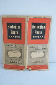
Chicago Burlington and Quincy RR Spring 1885 Public TimetableJM Hobby Supply and Railroad Artifact Auctions4.4(127)See Sold PriceFeb 24, 2024
Great Western RY November 1, 1880 Public TimetableJM Hobby Supply and Railroad Artifact Auctions4.4(127)See Sold PriceFeb 24, 2024
Illinois Central RR July 24, 1906 Western Lines Public TimetableJM Hobby Supply and Railroad Artifact Auctions4.4(127)See Sold PriceFeb 24, 2024
New York Central and Hudson River RR Public Timetable-November 3, 1901JM Hobby Supply and Railroad Artifact Auctions4.4(127)See Sold PriceFeb 24, 2024
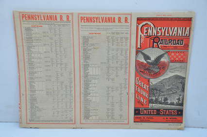
Pennsylvania Railroad July 8, 1885 Public TimetableJM Hobby Supply and Railroad Artifact Auctions4.4(127)See Sold PriceFeb 24, 2024
Early Chinese Buddha-Over 1000 years old- Rare, BeautyThe Buddha Gallery4.4(29)See Sold PriceMar 13, 2024
1818 RARE Geography Made Easy MAPS Jedidiah Morse Boston Indians Atlas AsiaSchilb Antiquarian Rare Books4.8(431)See Sold PriceMar 31, 2024
Pair of The Gateway to a Continent Books - Grand Central Zone and 1939 World's FairRail & Road Auctions4.6(165)See Sold PriceMar 07, 2024
Group of Ten Railroad Photographs, Maps, and Prints - New Jersey, Long Island, and New YorkRail & Road Auctions4.6(165)See Sold PriceMar 07, 2024
Carpet book, Sketches from the Steppes, of CentralHenry's Auktionshaus AG4.3(209)See Sold PriceMar 02, 2024
Twelve Pieces of Central and Western Railroad Flatware - Pullman, Burlington Route, Grand Pacific,Rail & Road Auctions4.6(165)See Sold PriceMar 08, 2024
WEST AFRICA Explorers' routes Senegal Ashanti. Mountains of Kong. SDUK 1857 mapJasper524.5(9.9k)See Sold PriceFeb 28, 2024
WEST AFRICA explorers' routes. Beaufort Gray Park Dochard Caillie. SDUK 1874 mapJasper524.5(9.9k)See Sold PriceFeb 28, 2024
NIGERIA explorers' routes. Lander Clapperton Oudney Denham Allen. SDUK 1874 mapJasper524.5(9.9k)See Sold PriceFeb 28, 2024
WEST AFRICA II. NIGERIA. Bight of Benin-Lake Chad. Yariba Houssa. SDUK 1851 mapJasper524.5(9.9k)See Sold PriceFeb 28, 2024
NIGERIA early explorers' routes. Lake Chad. Yariba Houssa Borgou SDUK 1844 mapJasper524.5(9.9k)See Sold PriceFeb 28, 2024
NIGERIA w/ early explorers' routes. Lake Chad Yariba Houssa Borgou.SDUK 1844 mapJasper524.5(9.9k)See Sold PriceFeb 28, 2024
ANTIQUE ILLUSTRATED HANDBOOK OF GEOGRAPHY AND TRAVEL IN ASIA, VOLUME 2, 1896NY Elizabeth 4.1(88)See Sold PriceMar 03, 2024