ATLAS of ANTIENT GEOGRAPHY by SAMUEL BUTLER 1843John McInnis Auctioneers,LLC4.5(505)See Sold PriceFeb 24, 2024
18TH C. ANTIQUE MAP: FRENCH & INDIAN WAR, FRAMEDThomaston Place Auction Galleries4.4(394)See Sold PriceFeb 24, 2024
Rand McNally Railroad Map Cabinet w/ 21 Railroad MapsRail & Road Auctions4.6(165)See Sold PriceMar 08, 2024
Keith Haring - Ink on New York Map, Best Buddies, Inscribed, Signed, and DatedSapphire Auction Gallery4.1(67)See Sold PriceMar 02, 2024
LATE 17TH C. FRENCH MAP OF THE NEW WORLD BY ALEXIS-HUBERT JAILLOT (1632-1712)Thomaston Place Auction Galleries4.4(394)See Sold PriceFeb 24, 2024
Central Railroad of New Jersey Map of Sandy Hook Route-ca. 1903JM Hobby Supply and Railroad Artifact Auctions4.4(127)See Sold PriceFeb 24, 2024
Lot of Six Mixed Atlas Box Cars-HO Scale-New in BoxJM Hobby Supply and Railroad Artifact Auctions4.4(127)See Sold PriceFeb 25, 2024
Rand McNally/Santa Fe Railroad Map of Iowa-1912JM Hobby Supply and Railroad Artifact Auctions4.4(127)See Sold PriceFeb 24, 2024
NICOLAES VISSCHER (NETHERLANDS, 1618-1709) MAP OF THE NEW WORLDThomaston Place Auction Galleries4.4(394)See Sold PriceFeb 24, 2024
17TH C. WORLD MAP BY NICOLAES VISSCHER (NETHERLANDS, 1618-1709)Thomaston Place Auction Galleries4.4(394)See Sold PriceFeb 24, 2024
Lot of Six Mixed Atlas Cabooses-HO Scale-New in BoxJM Hobby Supply and Railroad Artifact Auctions4.4(127)See Sold PriceFeb 25, 2024
SoldNew Orleans Guide with Scarce Map[New Orleans Guide with Scarce Map], New Orleans Press. Historical Sketch Book and Guide to New Orleans and Environs, with Map, New York, Will Coleman, 1885, softcover, 324 pages, with folding map, 12See Sold Price
SoldNEW ORLEANS GUIDE BOOK.THE PICAYUNE'S GUIDE TO NEW ORLEANS. REVISED AND ENLARGED FOURTH EDITION. 1900. 206 PAGES SEWN WITH MAPS. SCARCE.See Sold Price
SoldGroup of Three New Orleans Books- "Official ExposiGroup of Three New Orleans Books- "Official Exposition Guide- The New Orleans Guide, 1885, with a large folded map of the city; 1954 Social Register of New Orleans; and "The Citizens League- History oSee Sold Price
SoldAttributed to Jacques Tanesse, 1834 MapAttributed to Jacques Tanesse, "Plan of the City and Suburbs of New Orleans From Actual Surveys 1834", [no place], 1834, lithographed map, scarce map showing the fauburgs L'Anunciati, De La Course, SoSee Sold Price
SoldTravel & Tourist Ephemera: Maps, Menu, Cards Etc.Inc. 1926 Automobile Road Map of US, Illustrated Guide to New Orleans w/Maps, post cards inc. The Royal Family & colorful landscape postcards, 2 first day stamp covers plus. As found.See Sold Price
SoldBook- "Historical Sketch Book and Guide to New OrlBook- "Historical Sketch Book and Guide to New Orleans, Expositon Edition," 1884, with a period map of the City, H.- 7 in., W.- 5 3/8 in.See Sold Price
Sold1922 Haynes Guide Yellowstone National ParkThis is a scarce 1922 "Haynes New Guide and Motorists' Complete Road Log of Yellowstone National Park" by J.E. Haynes, official photographer of Yellowstone National Park. The guide contains more thanSee Sold Price
Sold1927 Haynes Guide to Yellowstone National ParkThis is a scarce 1927 "Haynes New Guide and Motorists' Complete Road Log of Yellowstone National Park" by J.E. Haynes, official photographer of Yellowstone National Park. The guide contains more thanSee Sold Price
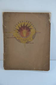
SoldThe Creole Tourist's Guide to the City of New OrleansEarly 1900s, undated, softcover, 127 pp, well illustrated, with fold-out map, 8vo. Shows toning, bumping, rubbing, wear and tear overall.See Sold Price
SoldThe Visitor's Guide to the World's ExpositionThe Visitor's Guide to the World's Exposition, lithographed guide of the City of New Orleans with a street map highlighting various points of interest throughout the city, printed in 1884 by the SouthSee Sold Price
Sold[America, Maps] 3 city maps, about 1910SCARCE EDITIONS OF EARLY 1900 OF THREE HANDY MAPS OF USA CITIES (NEW YORK, PHILADELPHIA AND NEW ORLEANS) [1.]: Rand, McNally Co.. New handy map of New York City with a large scale map of the borough oSee Sold Price
SoldWorld Fair items inc. New Orleans Map1st item: Visitor's Directory to the Buildings of the World's Industrial Exposition and Guide to Principal Exhibits, pamphlet from the 1884 Cotton Exhibition in New Orleans; Published by Patterson andSee Sold Price
SoldBook, "Historical Sketch Book & Guideto New Orleans and Environs." With rare folding map. Wraps. New York: Will H. Coleman, 1885. 1st edition, Good (+) condition in custom fitted box. Map has some separation on folds, and minor worming.See Sold Price
SoldNEW YORK CITY. MILLERS GUIDE.MILLER'S GUIDE TO CENTRAL PARK. 1865, ORIGINAL CLOTH BINDING WITH FOLD OUT MAP. NICE COPY OF A SCARCE BOOK.See Sold Price
SoldScarce early guide to San Jose with map 1872Heading: Author: Hare, George H. Title: Hare's Guide to San Jose and Vicinity, for tourists and new settlers. Containing directions to, and descriptions of all points of interest in the Valley; also,See Sold Price
SoldValentine MANUAL OF CORPORATION NEW YORK 1863 MapTitle: Manual of the Corporation of the City of New York Author: D. T. Valentine Publisher: Edmund Jones & Co., Printers Printing Year: 1863 Condition/Details: This antique volume is a scarce guidSee Sold Price
Sold4 Antiquarian Books on Arkansas incl Scarce WPAWPA. Arkansas. A Guide to the State. 1941. 1st. DJ. Hempstead. A Pictorial History of Arkansas...1890. 1st. Rebound with new endpapers. Howes 404. Rand McNally & Co.'s...Pocket Map and Shipper's GuideSee Sold Price
Sold[New Orleans Map] 1861[New Orleans Map], "Map of the City of New Orleans, and the Adjacent Towns", 1861, hand-colored lithograph map, from Charles Gardner's New Orleans Directory, lithographed by A. Hoen & Co., Baltimore,See Sold Price
Sold[Rare Norman's New Orleans Map][Rare Norman's New Orleans Map], "Norman's Plan of New Orleans & Environs", 1854, published by B.M. Norman, lithographed by G. Hayward, New York, folding pocket map, on blue-gray paper, with originalSee Sold Price
Sold[Battle of New Orleans Map][Battle of New Orleans Map] , "Plan of an Attack made by the British Forces on the American Lines in Advance of Orleans on the 8th January 1815", engraved map, hand-colored in blue and red, ND but c.See Sold Price
Sold[NEW ORLEANS MAP] Jacques Nicholas Bel[NEW ORLEANS MAP] Jacques Nicholas Bellin (French, 1703-1772) , "Plan de la Nouvelle Orleans", from Bellin's " Le Petit Atlas Maritime" , Paris 1764, originally published 1742, copper engraving, laidSee Sold Price
Sold[New Orleans Map][New Orleans Map], "Plan of New Orleans", 1860, hand-colored engraved map by Augustus Mitchell, sight 10 1/4 in. x 12 1/4 in., framedSee Sold Price
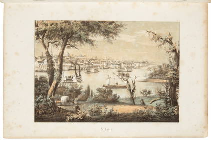
Sold[New Orleans Map][Antique New Orleans Map], "Lake Ponchartrain, Harbour & Breakwater, Louisiana", 1853, lithograph, folding map extracted from a book, sheet 9 in. x 38 inSee Sold Price
Sold1800s Antique New Orleans Map with Surrounding Areas1800s Antique New Orleans Map with Surrounding Areas. Measures 16'' x 22''.See Sold Price
Southern Pacific RR Book West By South-Half South-1890JM Hobby Supply and Railroad Artifact Auctions4.4(127)See Sold PriceFeb 24, 2024
LARGE LATE 17TH C. DUTCH CHART OF CANADA, GREAT LAKES, NEW FRANCE, LABRADOR, HUDSON BAY, BY PIERREThomaston Place Auction Galleries4.4(394)See Sold PriceFeb 24, 2024
Orleans by Christofle France Silverplate Flatware Service 10 Set 60 pcs DinnerMynt Auctions4.6(711)See Sold PriceFeb 24, 2024
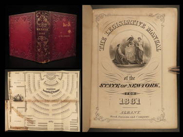
1861 Civil War Legislative Manual New York 84th Congress US Captain PROVENANCESchilb Antiquarian Rare Books4.8(431)See Sold PriceMar 31, 2024
Early Pennsylvania Railroad Literature - 1881 New York and Chicago Limited Timetable Brochure andRail & Road Auctions4.6(165)See Sold PriceMar 07, 2024
Arrowsmith & Lewis - Map of the United StatesTrillium Antique Prints & Rare Books4.5(33)See Sold PriceFeb 24, 2024
Kent & Sussex.- Moss (W.G.) The History and Antiquities of the Town and Port of Hastings, 1824; andForum Auctions4.4(54)See Sold PriceFeb 29, 2024
Two Hand-Colored 19th Century Maps of New Orleans and Louisiana, Larger- H.- 12 1/2 in., W.- 15 1/2Crescent City Auction Gallery4.3(233)See Sold PriceMar 08, 2024
Coca Cola 1993 New Orleans Basketball TubeRapid Estate Liquidators and Auction Gallery4.5(1.1k)See Sold PriceFeb 27, 2024
Hudson River Map & North American Postcards, 45Auctions at Showplace4.6(744)See Sold PriceFeb 13, 2025


![[America, Maps] 3 city maps, about 1910 (1 of 10)](https://p1.liveauctioneers.com/2198/56199/31005028_1_x.jpg?height=282&quality=70&version=1415833748)


![[New Orleans Map] 1861 (1 of 2)](https://p1.liveauctioneers.com/268/130466/66335167_1_x.jpg?height=282&quality=70&version=1542127114)
![[Rare Norman's New Orleans Map] (1 of 5)](https://p1.liveauctioneers.com/268/53920/26049310_1_x.jpg?height=282&quality=70&version=1397244133)
![[Battle of New Orleans Map] (1 of 6)](https://p1.liveauctioneers.com/268/176988/89092166_1_x.jpg?height=282&quality=70&version=1599167660)
![[NEW ORLEANS MAP] Jacques Nicholas Bel (1 of 4)](https://p1.liveauctioneers.com/268/1779/767584_1_x.jpg?height=282&quality=70&version=1108591439)
![[New Orleans Map] (1 of 1)](https://p1.liveauctioneers.com/268/44543/19827795_1_x.jpg?height=282&quality=70&version=1377785073)
![[New Orleans Map] (1 of 1)](https://p1.liveauctioneers.com/268/50498/23773542_1_x.jpg?height=282&quality=70&version=1390496908)