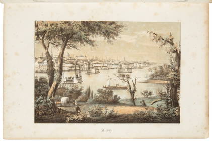
Sold[Rare Norman's New Orleans Map][Rare Norman's New Orleans Map], "Norman's Plan of New Orleans & Environs", 1854, published by B.M. Norman, lithographed by G. Hayward, New York, folding pocket map, on blue-gray paper, with originalSee Sold Price
SoldRare Norman Map of New Orleans, 1845[Rare Norman Map of New Orleans], "Norman's Plan of New Orleans & Environs, 1845 by Henry Moellhausen, Civil Engineer", published by B.M. Norman, printed by Shields & Hammond, 2 Camp St. N.O.,hand-colSee Sold Price
SoldRare "Norman's Plan of New Orleans & Environs"Rare "Norman's Plan of New Orleans & Environs" hand-colored lithograph map by Henry Moellhausen, published by B. M. Norman, New Orleans, 1845. Unframed. sheet 18-1/2" x 25-1/2" Provenance: Private colSee Sold Price
SoldNew Orleans Pocket Map 1869[Rare New Orleans Pocket Map], "New Plan of the City and environs of New Orleans, Compiled for Gardners Directory for 1869", lithographed by B. Simon, 116 Exchange Alley, N. Orleans, attached to the oSee Sold Price
Sold[Louisiana Books][Louisiana Books], a group of four antique books including; Histoire de la Louisiane..., by Le Page du Pratz, Paris, 1758, (vol. 1 only), with fold-out maps; Norman's New Orleans and Environs..., publSee Sold Price
SoldMap of New Orleans, Rollinson, publ. Charles del[Rare Map of New Orleans] Plan of the City and Suburbs of New Orleans from an Actual Survey made in 1815, by J. Tanesse, City Surveyor, published by Charles del Vecchio and P. Maspero , New Orleans, 1See Sold Price
SoldRare Nathaniel Cortlandt Curtis, "The Creole City ofRare Nathaniel Cortlandt Curtis, "The Creole City of New Orleans," map, copyright 1930, autographed lower right by Nathaniel Curtis, presented in an ebonized frame, H.- 28 3/4 in., W.- 21 1/2 in.See Sold Price
SoldFour Rare and Unusual Maps of New Orleans, LouisianaFour Rare and Unusual Maps of New Orleans, Louisiana and Bayou Teche including "Plan of the Front Part of the City of New Orleans in 1816", engraving by Joseph Pilie, published New Orleans, 1827, mattSee Sold Price
SoldU.S Coast Survey 1857 Map. New Orleans, Louisiana"Sketch II Showing The Progress of the Survey in Section No. VIII" A Rare Map centred on New Orleans and Lake Pontchartrain. Also showing Bon Secours Bay (Alabama) Isle au Breton Sound and Vermilion BSee Sold Price
SoldU.S Coast Survey 1856 Map. New Orleans, Louisiana"Sketch II Showing The Progress of the Survey in Section No. VIII" A Rare Map centred on New Orleans and Lake Pontchartrain. Also showing Bon Secours Bay (Alabama) Isle au Breton Sound and Vermilion BSee Sold Price
[MAP]. NEW ORLEANS. Exposition Map341. [MAP]. NEW ORLEANS INDUSTRIAL AND COTTON CENTENNIAL EXPOSITION. HANSELL, F[rederick] F. (publisher). Exposition Map of the City of New Orleans Published by F.F. Hansell.... Plan of New Orleans wiSee Sold Price
Sold[Map]. New Orleans Centennial Exposition130. [MAP]. NEW ORLEANS INDUSTRIAL AND COTTON CENTENNIAL EXPOSITION. The World's Industrial and Cotton Centennial Exposition, New Orleans, La., U.S.A. Department of Installation. Plan No. 2 Map of TheSee Sold Price
SoldRare Atlas of New Orleans, 1883[Rare Atlas of New Orleans], Robinson, Elisha and Roger Pidgeon. Atlas of the City of New Orleans, Louisiana. Based upon Surveys furnished by John F. Braun, Surveyor & Architect, New Orleans, New YorkSee Sold Price
Bachmann view of New OrleansBachmann, John (1814-1896). Birds eye view of New-Orleans. Color printed lithograph. New York, 1851 (First Edition). 26 x 34 3/4" sheet, 30 x 39 inches framed. Rare view of New Orleans by John BachmanSee Sold Price
SoldNorman's Chart of the Lower Mississippi, 1858Rare and Monumental "Norman's Chart of the Lower Mississippi, from Natchez to New Orleans" hand-colored lithograph after Marie Adrien Persac (French/Louisiana, 1823-1873) drawn survey of the plantatioSee Sold Price
Sold1864 Civil War General Benjamin Butler New Orleans1864 Civil War General Benjamin Butler New Orleans American Gulf Illustrated MAP A rare Civil War-era printing of James Parton’s biographical sketch on the life of General Benjamin Butler. Known asSee Sold Price
SoldBook, "Historical Sketch Book & Guideto New Orleans and Environs." With rare folding map. Wraps. New York: Will H. Coleman, 1885. 1st edition, Good (+) condition in custom fitted box. Map has some separation on folds, and minor worming.See Sold Price
SoldRare Sidney's Map Twelve Miles Around New YorkRare Sidney's Map Twelve Miles Around New York, Norman Friend (American/Danish, 1815-1871), "Sidney's Map Twelve Miles Around New York", 1849, chromo lithograph, 35.75"l x 36.25"w (sight), matted andSee Sold Price
SoldEarly Map of the 17th-Century Louisiana ProvinceRare Early Map of the 17th-Century Louisiana Province by Johann Baptist Homann (German, 1664-1724), after Father Louis Hennepin's 1687 account, hand-colored copper engraved map with Latin and French dSee Sold Price
SoldAmerica, Rare Early Map of the Americas"America", Rare Early Map of the Americas by Jodocus Hondius (Flemish/Dutch, 1563-1612) for a French edition of Mercator's Atlas, North and South America, hand-colored copper engraved map, published ASee Sold Price
SoldRare Colonial New Ebenezer Settlement Georgia MapRare Colonial Georgia Map of the New Ebenezer Settlement [Plan Von Neu Ebenezer...] hand-colored engraving by Matthias Seutter (German, 1678-1757), for Samuel Urlsperger's Ausfuhrliche Nachtricht vonSee Sold Price
SoldProvincial Pine Map or Document ChestRare Provincial Pine Eight-Drawer Map or Document Chest, late 19th century, the top with an applied molding over a bank of long narrow drawers, each with original handles and label plates, h. 37-1/2",See Sold Price
SoldLouisiana from Darby's Map, 1817Rare and Monumental Map of "Louisiana from Darby's Map, Published at Philadelphia 1816" by William Darby (British/American, 1775-1854), hand-colored engraving, published by Aaron Arrowsmith, HydrograpSee Sold Price
SoldRare and Large Hand-Colored Lithograph Map,Rare and Large Hand-Colored Lithograph Map, of "The Mississippi River: St. Joseph, Bruinsburg", 1864, published as a reconnaissance map for the use of the Mississippi Squadron, unframed, h. 23", w. 18See Sold Price
Crams Railroad Map of New York-1881JM Hobby Supply and Railroad Artifact Auctions4.4(126)See Sold PriceFeb 24, 2024
Crams Township and Railroad Map of New York-1890JM Hobby Supply and Railroad Artifact Auctions4.4(126)See Sold PriceFeb 24, 2024
Southern Pacific RR Book West By South-Half South-1890JM Hobby Supply and Railroad Artifact Auctions4.4(126)See Sold PriceFeb 24, 2024
WILLIAM TURNER Herball Pair Original c1568 Etchings Framed Leafs RARE!Luis Porretta Fine Arts4.3(10)See Sold PriceMar 02, 2024
1860 Life of Andrew Jackson Battle of NEW ORLEANS War of 1812 Alexander WalkerSchilb Antiquarian Rare Books4.8(422)See Sold PriceMar 31, 2024
1883 Mark Twain 1ed Life on the Mississippi St. Louis Missouri Steamboat CLASSICSchilb Antiquarian Rare Books4.8(422)See Sold PriceMar 31, 2024
[CIGARETTE CARD]. Little Person Prostitute (?) Cigarette Ca...Potter & Potter Auctions4.6(544)See Sold PriceMar 07, 2024
Two Hand-Colored 19th Century Maps of New Orleans and Louisiana, Larger- H.- 12 1/2 in., W.- 15 1/2Crescent City Auction Gallery4.3(231)See Sold PriceMar 08, 2024
Coca Cola 1993 New Orleans Basketball TubeRapid Estate Liquidators and Auction Gallery4.5(1.1k)See Sold PriceFeb 27, 2024
***Auction Highlight*** 1838 Capped Bust Half Dollar Near TOP POP! 50c Graded ms65+ By SEGS (fc)NaNLive Now
***Auction Highlight*** 1861-o Seated Half Dollar Rare FS-401/W-11 CSA Obverse 50c Graded ChoiceNaNLive Now
![[Rare Norman's New Orleans Map] First Image](https://p1.liveauctioneers.com/268/53920/26049310_1_x.jpg?height=282&quality=95&version=1397244133&width=282)
![[Rare Norman's New Orleans Map] (1 of 5)](https://p1.liveauctioneers.com/268/53920/26049310_1_x.jpg?height=282&quality=70&version=1397244133)
![[Rare Norman's New Orleans Map] First Image](https://p1.liveauctioneers.com/268/53920/26049310_1_x.jpg?height=282&quality=1&version=1397244133&width=282)


![[Louisiana Books] (1 of 2)](https://p1.liveauctioneers.com/268/27172/10261391_1_x.jpg?height=282&quality=70&version=1320494934)


![[MAP]. NEW ORLEANS. Exposition Map (1 of 10)](https://p1.liveauctioneers.com/514/38482/16500382_1_x.jpg?height=282&quality=70&version=1363615005)
![[Map]. New Orleans Centennial Exposition (1 of 1)](https://p1.liveauctioneers.com/514/11740/3078901_1_x.jpg?height=282&quality=70&version=1171465640)


![[CIGARETTE CARD]. Little Person Prostitute (?) Cigarette Ca... (1 of 2)](https://p1.liveauctioneers.com/928/318880/171361524_1_x.jpg?height=282&quality=70&version=1707501302)