Sold[Maps] Cassini, Russia Asiatica, 1796Giovanni Maria Cassini, La parte occidentale della Russia Asiatica [...]. La parte orientale della Russia Asiatica delineata sulle ultime osservazioni. 1796. Incisione in rame con coloritura coevSee Sold Price
SoldMAPS OF RUSSIA. Six maps, mainly of Russia.MAPS OF RUSSIA. Six maps, mainly of Russia. Engraved maps with hand coloring, unframed, comprising: Cassini, Il Governo di Arcangelo (1796), 24 x 16 in.; Schenck, Flandriae Comitatus (circa 1650-1700)See Sold Price
Russia Asiatica divisa. Asiatic Russia. Siberia. ZATTATITLE/CONTENT OF MAP: 'Russia Asiatica divisa nelle sue provincie' Asiatic Russia divided into its provinces. Siberia DATE PRINTED: Published in 1782. IMAGE SIZE: Approx 34.5 x 44.5cm, 13.5 x 17.5 incSee Sold Price
"Russia Asiatica divisa". Asiatic Russia. Siberia.TITLE/CONTENT OF MAP: 'Russia Asiatica divisa nelle sue provincie' Asiatic Russia divided into its provinces. Siberia The top image on the right hand side shows the entire map. To view a close up of tSee Sold Price
Russia Asiatica divisa…. Asiatic Russia. Siberia. ZATTA 1785 old antique mapTITLE/CONTENT OF MAP: 'Russia Asiatica divisa nelle sue provincie' Asiatic Russia divided into its provinces. Siberia DATE PRINTED: Published in 1782. IMAGE SIZE: Approx 34.5 x 44.5cm, 13.5 x 17.5 incSee Sold Price
1785 Zatta Map of Russia in Asia -- Russia Asiatica Divisa nelle sue ProvincieTitle: 1785 Zatta Map of Russia in Asia -- Russia Asiatica Divisa nelle sue Provincie Cartographer: A Zatta Year / Place: 1785, Venice Map Dimension (in.): 12.2 X 16.5 in. This map nicely shows the AsSee Sold Price
Zatta map of Russia Asia c.1785Title: Russia Asiatica Divisa nella sue Provincie Author: Zatta, Antonio Description: Copper-engraved map, hand-colored in outline. 31.2x41 cm.Well-engraved map of Russian Asia. Heading: zzgPlace PublSee Sold Price
SoldCassini (G.M.) Regional map of RussiaCassini (Giovanni Maria) I Governi di Olonechoi, Carelia, Bielozero, ed'Ingria nell'Imperio della Russia in Europa,regional map of north west Russia in Europe, with St Petersburg and Lapland,See Sold Price
MAP, Southern Norway, CassiniSouthern Norway. Giovanni Maria Cassini, La Norvegia Divisa nelle sue Provincie Delineat Sulle Ultime Osservazioni, from Nuovo Atlante Geografico Universale, 1796 (dated). Black & White. This handsomeSee Sold Price
SoldCassini (G.M.) L'Impero della RussiaCassini (Giovanni Maria) L'Impero della Russia in Europa,map of Russia divided into its administrative regions, large title vignette of running animals before a fortress, under a bower, from tSee Sold Price
SoldEntitled “Il Circolo della Bassa Sassonia, Roma 1796”Antique Italian Map of Rome Italy Entitled “Il Circolo della Bassa Sassonia, Roma 1796” by Giovanni Maria Cassini (Italian, 1725-1824) | A hand colored engraved map, dated 1796 | Title is translatSee Sold Price
SoldCassini (Giovanni Maria) La Tartaria CineseCassini (Giovanni Maria) La Tartaria Cinese,north east China, Mongolia, Korea, with part of Russia, including the Great Wall of China, engraved map with outline hand-colouring, 360 x 490mm., cSee Sold Price
SoldCassini (G.M.) I Governi di Moscoviae WoronezCassini (Giovanni Maria) I Governi di Moscoviae Woronez, nell'Imperio della Russia in Europa,regional map of central Russia in Europe, large title vignette of Cossacks in a landscape, under aSee Sold Price
SoldKentucky and Tennessee Map, 1796 HarrisCyrus Harris, "A Map of the State of Kentucky and the Tennessee Government Compiled from the Best Authorities," from Jedidiah Morse's The American Universal Geography. Boston: Thomas and Andrews, 1796See Sold Price
SoldMAP - Russia in Europe. De FerRussia in Europe. Nicholas de Fer, Estats du Grand Duc de Moscovie Suivant les Derniere Relations, 1705 (circa). Hand Color. Handsome, smaller map covering European Russia with part of Finland, showinSee Sold Price
SoldLochhead (Pub) 1811 Rare Map. Russia in Europe"The Southern Part of Russia in Europe with Russian and Little Tartary" Copper Engraved Map Published 1811 by William Lochhead, Berwick for "Modern Geography: And a Compendious General Gazetteer" RareSee Sold Price
SoldKentucky and Tennessee Map, 1796 HarrisCyrus Harris, "A Map of the State of Kentucky and the Tennessee Government Compiled from the Best Authorities," from Jedidiah Morse's The American Universal Geography. Boston: Thomas and Andrews, 1796See Sold Price
Sold6pc John Barrow China Maps. 17966pc John Barrow China Maps. All maps published April 12th, 1796 by George Nicol. Includes City and Harbour of Macao (32x23''), Chart- Pay-Ho River and Road from Pekin to Geho (23x16.75'' ), Chart- HanSee Sold Price
SoldGuthrie, William 1790 Antique Map. Russia or MuscovyCopper Engraved Map Published 1790, London for "A New Geographical, Historical and Commercial Grammar..." by William Guthrie. The maps are by John Senex, Thomas Kitchin and others. Folds as issued. EaSee Sold Price
SoldKentucky and Tennessee Map, 1796 Harris"A Map of the State of Kentucky and the Tennessee Government Compiled from the Best Authorities", by Cyrus Harris, engraved by Amos Doolittle, published by Thomas and Andrews, Boston, 1796. From "TheSee Sold Price
SoldMAP, Russia in Europe, JanvierRussia in Europe. Janvier/Lattre, Russie d'Europe avec la Partie la Plus Peuplee de Celle d'Asie..., 1760 (circa). Hand Color. This remarkably detailed map covers the region from the Gulf of Finland aSee Sold Price
SoldTallis, John (Pub) 1852 Map. Russia In AsiaSteel Engraved Map with Original Outline Hand Color Published 1852-56 by John Tallis, London for "The Universal Pronouncing Dictionary" by Thomas Wright. Drawn & Engraved by John Rapkin. Centre fold aSee Sold Price
SoldTallis, John (Pub) 1852 Map. Russia in EuropeSteel Engraved Map with Original Outline Hand Color Published 1852-56 by John Tallis, London for "The Universal Pronouncing Dictionary" by Thomas Wright. Drawn & Engraved by John Rapkin. Centre fold aSee Sold Price
SoldGross, Alexander 1920 Lot of 4 Large Maps. RussiaLarge Lithograph Maps Published 1920, London for "The Daily Telegraph Victory Atlas of the World" by Alexander Gross. Centre fold as published. Paper Size: 25 x 19.5 inch (64 x 49cm) Good ConditionSee Sold Price
Johann Homann Hand-Colored Map Engraving, c. 1730Auctions at Showplace4.5(726)See Sold PriceMar 17, 2024
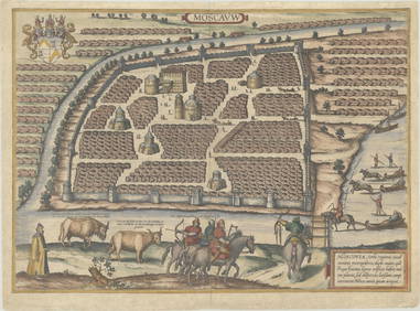
Duval - Pair: Map of Georgia & Map of Moscow, RussiaTrillium Antique Prints & Rare Books4.5(30)See Sold PriceFeb 24, 2024
Carey, pub. 1796 - A Chart of the West IndiesTrillium Antique Prints & Rare Books4.5(30)See Sold PriceFeb 24, 2024
Carey, pub. 1796 - Map of the State of MarylandTrillium Antique Prints & Rare Books4.5(30)See Sold PriceFeb 24, 2024
Carey, pub. 1796 - Map of GeorgiaTrillium Antique Prints & Rare Books4.5(30)See Sold PriceFeb 24, 2024
Carey, pub. 1796 - Map of The State of South CarolinaTrillium Antique Prints & Rare Books4.5(30)See Sold PriceFeb 24, 2024
Carey, pub. 1796 - Map of KentuckyTrillium Antique Prints & Rare Books4.5(30)See Sold PriceFeb 24, 2024
Carey, pub. 1796 - Map of the Tennassee State formerly part of North Carolina (Tennessee)Trillium Antique Prints & Rare Books4.5(30)See Sold PriceFeb 24, 2024
1816 MAP SOUTHERN PART OF RUSSIA or MUSCOVY in EUROPE copper engraving ANTIQUEJasper524.5(9.8k)See Sold PriceFeb 27, 2024
1816 MAP NORTHERN PART OF RUSSIA or MUSCOVY in EUROPE copper engraving ANTIQUEJasper524.5(9.8k)See Sold PriceFeb 27, 2024
1749 MAP CARTE DE LA TARTARIE ORIENTALE RUSSIA & CHINA antique EASTERN TARTARYJasper524.5(9.8k)See Sold PriceFeb 27, 2024
CATHERINE II THE GREAT: (1762-1796)International Autograph Auctions Europe S.L.4.5(52)See Sold PriceMar 14, 2024
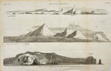
Antique Print with Coastal Views of Kamchatka in Russia by Cook, 1803Proverde Auctions4.3(3)See Sold PriceFeb 28, 2024


![[Maps] Cassini, Russia Asiatica, 1796 First Image](https://p1.liveauctioneers.com/1306/149407/75466440_1_x.jpg?height=282&quality=95&version=1567670607&width=282)
![[Maps] Cassini, Russia Asiatica, 1796 (1 of 2)](https://p1.liveauctioneers.com/1306/149407/75466440_1_x.jpg?height=282&quality=70&version=1567670607)
![[Maps] Cassini, Russia Asiatica, 1796 First Image](https://p1.liveauctioneers.com/1306/149407/75466440_1_x.jpg?height=282&quality=1&version=1567670607&width=282)