ATLAS of ANTIENT GEOGRAPHY by SAMUEL BUTLER 1843John McInnis Auctioneers,LLC4.6(502)See Sold PriceFeb 24, 2024
18TH C. ANTIQUE MAP: FRENCH & INDIAN WAR, FRAMEDThomaston Place Auction Galleries4.4(386)See Sold PriceFeb 24, 2024
Rand McNally Railroad Map Cabinet w/ 21 Railroad MapsRail & Road Auctions4.6(165)See Sold PriceMar 08, 2024
Keith Haring - Ink on New York Map, Best Buddies, Inscribed, Signed, and DatedSapphire Auction Gallery4(67)See Sold PriceMar 02, 2024
LATE 17TH C. FRENCH MAP OF THE NEW WORLD BY ALEXIS-HUBERT JAILLOT (1632-1712)Thomaston Place Auction Galleries4.4(386)See Sold PriceFeb 24, 2024
Central Railroad of New Jersey Map of Sandy Hook Route-ca. 1903JM Hobby Supply and Railroad Artifact Auctions4.4(126)See Sold PriceFeb 24, 2024
Lot of Six Mixed Atlas Box Cars-HO Scale-New in BoxJM Hobby Supply and Railroad Artifact Auctions4.4(126)See Sold PriceFeb 25, 2024
Rand McNally/Santa Fe Railroad Map of Iowa-1912JM Hobby Supply and Railroad Artifact Auctions4.4(126)See Sold PriceFeb 24, 2024
NICOLAES VISSCHER (NETHERLANDS, 1618-1709) MAP OF THE NEW WORLDThomaston Place Auction Galleries4.4(386)See Sold PriceFeb 24, 2024
17TH C. WORLD MAP BY NICOLAES VISSCHER (NETHERLANDS, 1618-1709)Thomaston Place Auction Galleries4.4(386)See Sold PriceFeb 24, 2024
Lot of Six Mixed Atlas Cabooses-HO Scale-New in BoxJM Hobby Supply and Railroad Artifact Auctions4.4(126)See Sold PriceFeb 25, 2024
Sold6pc John Barrow China Maps. 17966pc John Barrow China Maps. All maps published April 12th, 1796 by George Nicol. Includes City and Harbour of Macao (32x23''), Chart- Pay-Ho River and Road from Pekin to Geho (23x16.75'' ), Chart- HanSee Sold Price
SoldChina Map 1796 Sir John BarrowChina Map 1796 Sir John Barrow A Chart on Merchant's Projection containing the track and soundings of the Lion^ the Hindoostan and Tenders from TURON-BAY in COCHIN-CHINA to the mouth of the Pei-Ho RivSee Sold Price
8 Copperplate Engravings of China, etc. 1796Title: 8 Copperplate Engravings of China, etc. Author: Alexander, William, John Barrow, Edwards, et. al Description: 8 copperplate engravings. Images of various sizes on folio sheets of approximatelySee Sold Price
Sold8 Copperplate Engravings of China, etc. 1796Title: 8 Copperplate Engravings of China, etc. Author: Alexander, William, John Barrow, Edwards, et. al Description: 8 copperplate engravings. Images of various sizes on folio sheets of approximatelySee Sold Price
SoldBarrow (John) Sketch of a Journey in ChinaBarrow (Sir John) Sketch of a Journey from Hang-Tchoo-Foo to Quang-Tchoo-Foo or Canton in China,engraved map with full hand-colouring, 640 x 455mm., central horizontal fold, slightly discolourSee Sold Price
SoldBarrow (John) Sketch of ....Canton in ChinaBarrow (John) Sketch of a Journey from Hang-Tchoo-Foo to Quang-Tchoo-Foo, or Canton in China,large map from George Staunton's An Authentic Account of an Embassy from the King of Great BritainSee Sold Price
Sold24 Copperplate Engravings of China, etc.Author: Alexander, William, John Barrow, Edwards, et. al 24 copperplate engravings, including 5 folding plates. Images of various sizes on folio sheets of approximately 17x23. Images include maps, arcSee Sold Price
SoldChart of English mission to China 1796Heading: Author: Barrow, John Title: A General Chart on Mercator's Projection, to Shew the Track of the Lion and Hindostan from England to the Gulph of Pekin in China, … also the Limits of the ChinSee Sold Price
SoldWilkes, John 1796 Map. Modern AfricaCopper Engraved Map Published 1796-1828 London for "Encyclopaedia Londinensis, or universal dictionary of arts, sciences and literature" by John Wilkes et al. Paper Size: 10.5 x 8.5 inch (27 x 22cm) GSee Sold Price
SoldWilkes, John 1796 Map. South AmericaCopper Engraved Map Published 1796-1828 London for "Encyclopaedia Londinensis, or universal dictionary of arts, sciences and literature" by John Wilkes et al. Paper Size: 10.5 x 8.5 inch (27 x 22cm) GSee Sold Price
[Travel & Exploration] [China] Barrow, John, Travels in[Travel & Exploration] [China] Barrow, John Travels in China, Containing Descriptions, Observations, and Comparisons, Made and Collected in the Course of a Short Residence at the Imperial Palace of YuSee Sold Price
SoldJohn Barrow. Travels in China. 1804. First edition[Asia/China] Barrow, John. Travels in China, Containing Descriptions, Observations, and Comparisons, Made and Collected in the Course of a Short Residence at the Imperial Palace of Yuen-Min-Yuen . . .See Sold Price
Sold[China] Barrow, John. Travels in China.[China] Barrow, John. Travels in China. London: T. Cadwell and W. Davies, 1806. Second edition. Eight plates (five hand-colored, two double-page), including frontispiece. Contemporary mottled calf. 4tSee Sold Price
SoldChina.- Barrow (John) - Travels in China,first edition , hand-coloured aquatint portrait frontispiece and 4 hand-coloured aquatint or stipple-engraved plates, 3 other engraved plates, 2 double-page, some pencil marginalia, plates a little soSee Sold Price
SoldJohn Barrow Travels in China containing descriptionsChina John Barrow Travels in China containing descriptions observations and comparisons made and collected in the course of a short residence at the Imperial Palace of Yuen-Min-Yuen and on a subsequenSee Sold Price
SoldBarrow, John Voyage en Chine, formant le compléChina Barrow John Voyage en Chine formant le complément du voyage de Lord Macartney contenant des Observations et des Descriptions faites pendant le séjour de l'Auteur dans le Palais ImpSee Sold Price
Sold1846 1ed Barrow ARCTIC Voyages & Discovery1846 1ed Barrow ARCTIC Voyages & Discovery John Franklin Parry Ross HUGE MAP John Barrow was an important 18th-century English naval historian who is best known for his treatises on voyages. In 1846,See Sold Price
SoldTallis, John (Pub) 1852 Map. China and Birmah. BurmaSteel Engraved Map with Original Outline Hand Color Published 1852-56 by John Tallis, London for "The Universal Pronouncing Dictionary" by Thomas Wright. Drawn & Engraved by John Rapkin. Centre fold aSee Sold Price
SoldBarrow, John, "Travels in China"Barrow, John, "Travels in China" (London, T. Cadell & W. Davies 1806); 4to; later embossed purple cloth over stiff boards (spine missing, panels detached); Second Edition, an account of China by JohnSee Sold Price
1796 John Reid Map of ConnecticutAn important map of Connecticut issued by John Reid in 1796. This map is from Reid's American Atlas, only the second atlas to be published in America..See Sold Price
SoldBarrow (John) - Travels in China,second edition , hand-coloured aquatint portrait frontispiece and 4 hand-coloured aquatint or stipple-engraved plates, 3 other engraved plates, 2 folding, offsetting affecting some plates, some spottiSee Sold Price
SoldBarrow (John) - Travels in China,first edition, hand-coloured aquatint portrait frontispiece and 4 hand-coloured aquatint or stipple-engraved plates, 3 other engraved plates, 2 double-page, some light foxing and staining to upper rigSee Sold Price
SoldBarrow (John) Travels in ChinaBarrow (John) Travels in China, second edition, hand-coloured aquatint portrait frontispiece and 3 plates, 3 engraved plates only (of 4), 2 double-page, printed music, 1 double-page plate tornSee Sold Price
SoldBarrow (John) Travels in ChinaBarrow (John) Travels in China, 8 engraved plates including 5 hand-coloured, most linen-backed, soiled, ex-library copy with ink stamp to plates, modern panelled calf "antique style", 4to, 180See Sold Price
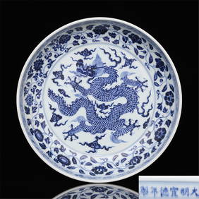
32 cm Ming Xuande Year System Blue and White Porcelain Wrapped Dragons Wear Cloud PatternsFind Treasure4.1(15)See Sold PriceApr 07, 2024
17TH C. MAP OF THE BERKSHIRES BY JOHN SPEED, FRAMEDThomaston Place Auction Galleries4.4(386)See Sold PriceFeb 24, 2024
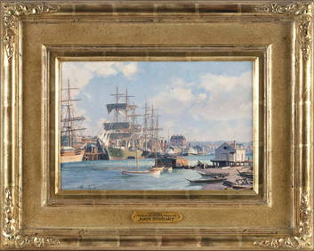
JOHN STOBART (Massachusetts/Florida/England, 1929-2023), "Victoria, View from Songhee Point, 1891".,Eldred's4.7(409)See Sold PriceFeb 27, 2024
CHINESE PEOPLE'S REPUBLIC ERA PUNCH BOWLJohn McInnis Auctioneers,LLC4.6(502)See Sold PriceFeb 25, 2024
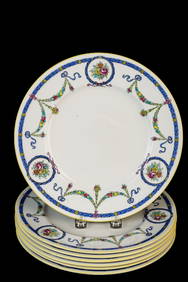
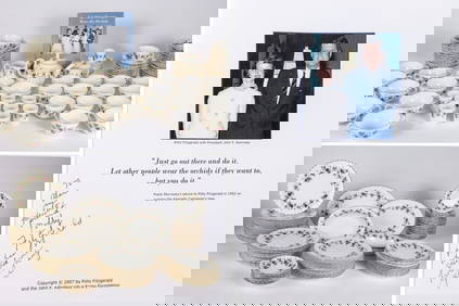
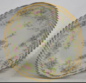
THE FITZGERALD FAMILY TEA and DINNER SERVICEJohn McInnis Auctioneers,LLC4.6(502)See Sold PriceFeb 25, 2024
1963 J.F.K. for US PRESIDENT RE-ELECTION MATERIALJohn McInnis Auctioneers,LLC4.6(502)See Sold PriceFeb 25, 2024
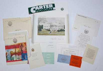
1977 INAUGURATION of PRESIDENT JIMMY CARTERJohn McInnis Auctioneers,LLC4.6(502)See Sold PriceFeb 25, 2024
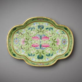
A LIME-GREEN AND FAMILLE-ROSE 'BUTTERFLY' TEA TRAY, JIAQING MARK AND PERIODGalerie Zacke 4.4(50)See Sold PriceMar 01, 2024
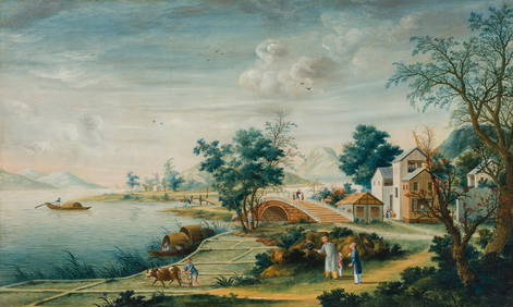
LANDSCAPE WITH PLOUGHMAN', EX JOHN LE CARRE COLLECTIONGalerie Zacke 4.4(50)See Sold PriceMar 01, 2024
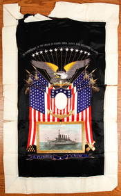
(Early 20th c) MEMENTO of the U.S.S. MONTANAJohn McInnis Auctioneers,LLC4.6(502)See Sold PriceFeb 25, 2024
Carey, pub. 1796 - Map of KentuckyTrillium Antique Prints & Rare Books4.5(30)See Sold PriceFeb 24, 2024
Carey, pub. 1796 - Map of the Tennassee State formerly part of North Carolina (Tennessee)Trillium Antique Prints & Rare Books4.5(30)See Sold PriceFeb 24, 2024
John Senex Map of Louisiana & Mississippi RiverWillow Auction House4.5(283)See Sold PriceMar 14, 2024


![[Travel & Exploration] [China] Barrow, John, Travels in (1 of 2)](https://p1.liveauctioneers.com/65/159074/80331265_1_x.jpg?height=282&quality=70&version=1578425020)

![[China] Barrow, John. Travels in China. (1 of 3)](https://p1.liveauctioneers.com/928/104923/53749665_1_x.jpg?height=282&quality=70&version=1496865216)