ATLAS of ANTIENT GEOGRAPHY by SAMUEL BUTLER 1843John McInnis Auctioneers,LLC4.6(502)See Sold PriceFeb 24, 2024
18TH C. ANTIQUE MAP: FRENCH & INDIAN WAR, FRAMEDThomaston Place Auction Galleries4.4(386)See Sold PriceFeb 24, 2024
Rand McNally Railroad Map Cabinet w/ 21 Railroad MapsRail & Road Auctions4.6(165)See Sold PriceMar 08, 2024
Keith Haring - Ink on New York Map, Best Buddies, Inscribed, Signed, and DatedSapphire Auction Gallery4(67)See Sold PriceMar 02, 2024
LATE 17TH C. FRENCH MAP OF THE NEW WORLD BY ALEXIS-HUBERT JAILLOT (1632-1712)Thomaston Place Auction Galleries4.4(386)See Sold PriceFeb 24, 2024
Central Railroad of New Jersey Map of Sandy Hook Route-ca. 1903JM Hobby Supply and Railroad Artifact Auctions4.4(126)See Sold PriceFeb 24, 2024
Lot of Six Mixed Atlas Box Cars-HO Scale-New in BoxJM Hobby Supply and Railroad Artifact Auctions4.4(126)See Sold PriceFeb 25, 2024
Rand McNally/Santa Fe Railroad Map of Iowa-1912JM Hobby Supply and Railroad Artifact Auctions4.4(126)See Sold PriceFeb 24, 2024
NICOLAES VISSCHER (NETHERLANDS, 1618-1709) MAP OF THE NEW WORLDThomaston Place Auction Galleries4.4(386)See Sold PriceFeb 24, 2024
17TH C. WORLD MAP BY NICOLAES VISSCHER (NETHERLANDS, 1618-1709)Thomaston Place Auction Galleries4.4(386)See Sold PriceFeb 24, 2024
Lot of Six Mixed Atlas Cabooses-HO Scale-New in BoxJM Hobby Supply and Railroad Artifact Auctions4.4(126)See Sold PriceFeb 25, 2024
Ranally Physical-Political Africa ...Title/Content of Map: Ranally Physical-Political Africa ... Date: 9/1/1948 Cartographer: RAND MCNALLY & CO. Size: 55.5Height - 39Width Publisher: RAND MCNALLY & CO. Wall size Africa map prior to indepSee Sold Price
Ranally Physical-Political Africa.Title/Content of Map: Ranally Physical-Political Africa. Date: 1948 Cartographer: RAND MCNALLY & COMPANY Size: 55.5Height - 39.5Width Publisher: RAND MCNALLY & COMPANY Schoolroom map dissected and susSee Sold Price
Ranally Physical-Political North AmericaTitle: Ranally Physical-Political North America Publication Date: 4/1/1937 Cartographer: RAND MCNALLY & COMPANY Dimensions: 55.5Height - 29.5Width Publisher: RAND MCNALLY & COMPANY Dissected schoolrooSee Sold Price
Ranally Physical-Political EuropeTitle/Content of Map: Ranally Physical-Political Europe Date: 1950 Cartographer: RAND MCNALLY & COMPANY Size: 55.6Height - 39.75Width Publisher: RAND MCNALLY & COMPANY Schoolroom map dissected and susSee Sold Price
Ranally Physical-Political AsiaTitle/Content of Map: Ranally Physical-Political Asia Date: 1935 Cartographer: RAND MCNALLY & COMPANY Size: 51Height - 38.5Width Publisher: RAND MCNALLY & COMPANY Schoolroom map dissected and suspendeSee Sold Price
Ranally Physical-Political North AmericaTitle: Ranally Physical-Political North America Publication Date: 4/1/1937 Cartographer: RAND MCNALLY & COMPANY Publisher: RAND MCNALLY & COMPANY Size: 55.5Height - 29.5Width Dissected schoolroom wallSee Sold Price
Ranally Physical-Political North AmericaPublication Date: 4/1/1937 Title: Ranally Physical-Political North America Cartographer: RAND MCNALLY & COMPANY Publisher: RAND MCNALLY & COMPANY Height: 55.5 Width: 29.5 Dissected schoolroom wall mapSee Sold Price
Ranally Physical-Political Eastern HemisphereTitle: Ranally Physical-Political Eastern Hemisphere Cartographer: RAND MCNALLY & COMPANY Date: 09 01 1934 Publisher: RAND MCNALLY & COMPANY Size: 54.75Height - 39Width Additional Info: Schoolroom mapSee Sold Price
Ranally Physical-Political South AmericaTitle: Ranally Physical-Political South America Publication Date: 1947 Cartographer: RAND MCNALLY & COMPANY Publisher: RAND MCNALLY & COMPANY Size: 55.25Height - 39.25Width Schoolroom map dissected anSee Sold Price
Ranally Physical-Political EuropePublication Date: 1950 Title: Ranally Physical-Political Europe Cartographer: RAND MCNALLY & COMPANY Publisher: RAND MCNALLY & COMPANY Height: 55.6 Width: 39.75 Schoolroom map dissected and suspendedSee Sold Price
Ranally Physical-Political Europe.Title: Ranally Physical-Political Europe. Publication Date: 1937 Cartographer: RAND MCNALLY & COMPANY Publisher: RAND MCNALLY & COMPANY Dimension: 55.5Height - 39.5Width Schoolroom map dissected and sSee Sold Price
Ranally Physical-Political EuropeTitle: Ranally Physical-Political Europe Publication Date: 1950 Cartographer: RAND MCNALLY & COMPANY Publisher: RAND MCNALLY & COMPANY Dimension: 55.6Height - 39.75Width Schoolroom map dissected and sSee Sold Price
SoldEARLY MCNALLY LIBRARY GLOBE WITH STAND 16" DIAMETEEARLY MCNALLY LIBRARY GLOBE WITH STAND 16" DIAMETER - "SPECIAL RANALLY PHYSICAL POLITICAL GLOBE", OVERALL WITH WOOD STAND 20 X 19See Sold Price
Ranally Political Series. Africa.Title/Content of Map: Ranally Political Series. Africa. Date: 1931 Cartographer: RAND MCNALLY & COMPANY Size: 55Height - 39Width Publisher: RAND MCNALLY & COMPANY Schoolroom map dissected and suspendeSee Sold Price
Cram's Simplified Physical-Political Map of Africa...Title/Content of Map: Cram's Simplified Physical-Political Map of Africa... Cartographer: CRAM, THE GEORGE F. COMPANY, INC. Date: c1965 Publisher: THE GEORGE F. CRAM COMPANY, INC. Size: 42Height - 50.See Sold Price
Africa Physical-PoliticalTitle/Content of Map: Africa Physical-Political Date: c1930-1940 Publisher: American Geographical Society Size: 80Height - 71Width Huge nearly 6 by 7 foot wall map with stacks of valuable informationSee Sold Price
Scarce, Detailed American Geographical Society Wall MapAfrica Physical-Political. Lithographed map. 1930-1940 ca. 80" x 71" sheet. Huge nearly 6 by 7 foot wall map with stacks of valuable information in panels on either side of southern Africa. Printed coSee Sold Price
Physical and political map of Africa. 1871.Print from steel engraving titled „Carte physique et politique de L‘ Afrique“.Author/compiler - MM. Drioux et Ch. Leroy.Engraved by Jenotte.Notes: 22. 23/67. 68.From „Atlas universel et classiSee Sold Price
SoldGross, Alexander 1920 Pair of Large Maps. AfricaAfrica Political and Physical. Large Lithograph Maps Published 1920, London for "The Daily Telegraph Victory Atlas of the World" by Alexander Gross. Centre fold as published. Paper Size: 25 x 19.5 incSee Sold Price
Gross, Alexander 1920 Pair of Large Maps. AfricaAfrica Political and Physical. Large Lithograph Maps Published 1920, London for "The Daily Telegraph Victory Atlas of the World" by Alexander Gross. Centre fold as published. Paper Size: 25 x 19.5 incSee Sold Price
SoldBrockhaus (Pub) 1890's Lot of 6 Maps of AfricaIncl German East Africa, Egypt, Equatorial Africa and Political, Ethnographic and Physical Maps of the African Continent. Lithograph Maps Published 1892-98 by F. A. Brockhaus, Leipzig for "Brockhaus'See Sold Price
AfricaPublication Date: c1960 Title: Africa Publisher: USGS Height: 39 Width: 43 Physical-Political. A very detailed map for its size, showing topography, countries, cities, railroads, highways and trails,See Sold Price
Antique Puck Magazine Color Political IllustrationThe Benefit Shop Foundation Inc.4.3(2.9k)See Sold PriceFeb 28, 2024
Antq Puck Magazine F.Graetz Political IllustrationThe Benefit Shop Foundation Inc.4.3(2.9k)See Sold PriceFeb 28, 2024
Antq Puck Magazine Keppler Political IllustrationThe Benefit Shop Foundation Inc.4.3(2.9k)See Sold PriceFeb 28, 2024
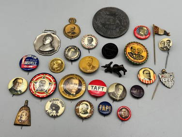
Group of Early Political Buttons; Wilson, Taft, Roosevelt, McKinley, Whisk BroomDana J. Tharp Auctions4.7(268)See Sold PriceFeb 24, 2024
Group of Political Buttons: 1892 Benjamin Harrison, GOP Sterling ElephantDana J. Tharp Auctions4.7(268)See Sold PriceFeb 24, 2024
Group of FDR and Truman Political Campaign and Satire ButtonsDana J. Tharp Auctions4.7(268)See Sold PriceFeb 24, 2024
Dogon Granary Door With Carved Ancestral Figures Mali AfricaDana J. Tharp Auctions4.7(268)See Sold PriceFeb 24, 2024
German Deutsche Africa Corps Pith Helmet. Felt olive body w...Potter & Potter Auctions4.6(539)See Sold PriceMar 07, 2024
Group of 50+ Vintage Political Campaign ButtonsMatthew Bullock Auctioneers4.7(1.8k)See Sold PriceFeb 24, 2024
De Jode, Rare, pub. 1593 - Map of Africa (Africae Vera Forma, et Situs)Trillium Antique Prints & Rare Books4.5(30)See Sold PriceFeb 24, 2024
Mexico, Central America and West Indies Physical PoliticalJasper524.5(9.8k)See Sold PriceFeb 27, 2024
SECOND WORLD WAR AFRICA. European colonies & German mandates 1940 old mapJasper524.5(9.8k)See Sold PriceFeb 28, 2024
COLONIAL AFRICA. British East/Central/South Africa. Bechuanaland 1899 old mapJasper524.5(9.8k)See Sold PriceFeb 28, 2024
COLONIAL FRENCH NORTH AFRICA. Afrique du Nord. Politique. Political 1929 mapJasper524.5(9.8k)See Sold PriceFeb 28, 2024
AFRICA. Political Map of showing International Boundaries 1936 old vintageJasper524.5(9.8k)See Sold PriceFeb 28, 2024
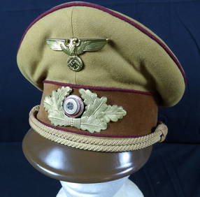
WW2 WWII german NSDAP political leaders Peaked Officer VisorEagles Corps International LLC4.6(107)See Sold PriceMar 10, 2024
1930's / 40's Chicago Political Campaign Umbrella.Direct Auction Galleries 4.7(322)See Sold PriceFeb 24, 2024
1884 Harpers Weekly Antq Illustr Political MagazineThe Benefit Shop Foundation Inc.4.3(2.9k)See Sold PriceMar 20, 2024