ATLAS of ANTIENT GEOGRAPHY by SAMUEL BUTLER 1843John McInnis Auctioneers,LLC4.5(505)See Sold PriceFeb 24, 2024
18TH C. ANTIQUE MAP: FRENCH & INDIAN WAR, FRAMEDThomaston Place Auction Galleries4.4(393)See Sold PriceFeb 24, 2024
Rand McNally Railroad Map Cabinet w/ 21 Railroad MapsRail & Road Auctions4.6(165)See Sold PriceMar 08, 2024
Keith Haring - Ink on New York Map, Best Buddies, Inscribed, Signed, and DatedSapphire Auction Gallery4(67)See Sold PriceMar 02, 2024
LATE 17TH C. FRENCH MAP OF THE NEW WORLD BY ALEXIS-HUBERT JAILLOT (1632-1712)Thomaston Place Auction Galleries4.4(393)See Sold PriceFeb 24, 2024
Central Railroad of New Jersey Map of Sandy Hook Route-ca. 1903JM Hobby Supply and Railroad Artifact Auctions4.4(127)See Sold PriceFeb 24, 2024
Lot of Six Mixed Atlas Box Cars-HO Scale-New in BoxJM Hobby Supply and Railroad Artifact Auctions4.4(127)See Sold PriceFeb 25, 2024
Rand McNally/Santa Fe Railroad Map of Iowa-1912JM Hobby Supply and Railroad Artifact Auctions4.4(127)See Sold PriceFeb 24, 2024
NICOLAES VISSCHER (NETHERLANDS, 1618-1709) MAP OF THE NEW WORLDThomaston Place Auction Galleries4.4(393)See Sold PriceFeb 24, 2024
17TH C. WORLD MAP BY NICOLAES VISSCHER (NETHERLANDS, 1618-1709)Thomaston Place Auction Galleries4.4(393)See Sold PriceFeb 24, 2024
Lot of Six Mixed Atlas Cabooses-HO Scale-New in BoxJM Hobby Supply and Railroad Artifact Auctions4.4(127)See Sold PriceFeb 25, 2024
Sold4 Engravings of Maps of Jerusalem and the Land ofFour impressive engravings of Jerusalem, the Temple and the Land of Israel. * Engraving with an early map of the Land of Israel, including a description of the Temple. English. 38x50 cm. Fine-very finSee Sold Price
SoldA Collection [4] of Maps - Engravings of the Land of* Map of Canaan or the Holy Land. Published by Baldwin & Gradock, London 1855. Size: 18x15 cm. * Journeyings of the Israelites from Egypt to Canaan. London 1831. Size: 23x15 cm. * Palestine. ASee Sold Price
Sold"Masa Derech Sifrei HaKodesh" - Heinrich Bunting -378 [6] pages. Thick travelogue in German by M. Heinrich Bunting, published in Frankfurt in 1752. Includes tens of engravings and maps of the Holy Land, Jerusalem, Temple Mount, Temple vessels and morSee Sold Price
SoldMAP - Jerusalem, Holy Land. DanckertsJerusalem, Holy Land. Cornelius Danckerts, De Stadt Ierusalem, 1718 (published). Hand Color. Great bird's-eye plan of the ancient holy city flanked by engravings of religious icons. At the bottom areSee Sold Price
SoldMAP, Jerusalem, Holy Land, I. PutteJerusalem, Holy Land. I. Putte, Ierusalem, 1718 (published). Hand Color. This detailed bird's-eye plan was one of the most popular plans of Jerusalem during the seventeenth century. While it is imaginSee Sold Price
MAP, Jerusalem, Holy Land, SavryJerusalem, Holy Land. Jacob Savry, De Heylige en Wytvermaerde Stadt Ierusalem, Eerst Genaemt Salem, 1648 (dated). Hand Color. This detailed bird's-eye view is based on Claes Janszoon Visscher's depictSee Sold Price
SoldMAP, Jerusalem, Holy Land, DetleffsenJerusalem, Holy Land. Johann Detleffsen, Die Heylige und Weitberuhmte Stadt Jerusalem Erstlich Genant Salem..., 1716 (circa). Hand Color. This rare map was published in a German bible by Johann DetlefSee Sold Price
SoldMAP, Jerusalem, Holy Land, VisscherJerusalem, Holy Land. Nicolas Visscher, De Heylige en Wytvermaerde Stadt Ierusalem Eerst Genaemt Salem Genesis 14. Vers 18, 1665 (published). Hand Color. This detailed bird's-eye view was one of the mSee Sold Price
SoldMAP, Jerusalem, Holy Land, VisscherJerusalem, Holy Land. Nicolas Visscher, De Heylige en Wytvermaerde Stadt Ierusalem eerst Genaemt Salem Genesis 14. Vers 18, 1664 (published). Hand Color. This detailed bird's-eye view was one of the mSee Sold Price
SoldHoly Land.- Keur (Pieter, publisher) Five biblical mapsHoly Land.- Keur (Pieter, publisher) Five biblical maps of the Holy Land, a plan of Jerusalem, and 4 biblical maps of Israel and its environs, all illustrated with biblical vignettes and scenes, engraSee Sold Price
Pair Antique Map EngravingsPair of Antique Map Engravings "Complete Map Of The Holy Land By Samuel Dunn, Parts 1 & 2" Framed and under glass. Impressions measure 13-1/2" x 19-3/4", frames measure 20-1/2" x 26-1/4". Condition: TSee Sold Price
SoldComplete Works of Flavius JosephusTitle: The Genuine and Complete Works of Flavius Josephus Author: Josephus, Flavius Description: (724), + [4] pp. 60 copperplate engravings including folding plan of Jerusalem and 2 maps. Maps hand coSee Sold Price
SoldComplete Works of Flavius JosephusTitle: The Genuine and Complete Works of Flavius Josephus Author: Josephus, Flavius Description: (724), + [4] pp. 60 copperplate engravings including folding plan of Jerusalem and 2 maps. Maps hand coSee Sold Price
Israel. Collection of 4 engravings of '700 - '800.Israele. Anonimo. Raccolta di 4 incisioni del '700 e '800. XVIII e XIX secolo The church of the Holy Sepulcre. Middleton, 1777 295x203mm. Caesarea. Secolo XVIIISee Sold Price
Sold1887 Hand Colored Map Palestine & Environs of Jerusalem1887 Hand Colored Engraving "Map of Palestine" with an inset of the "Environs of Jerusalem"Signed in plate: Bradley 1887Size: Approximately 8 1/4" x 11 1/4"Condition: A fSee Sold Price
Sold1891 Verplanck Colvin Report on the Progress of the1891 Verplanck Colvin Report on the Progress of the State Land Survey of the State of New York w/ 4 charts & maps in sleeve, engravings, & photo prints & 1896 Report of the Superintendent of the StateSee Sold Price
SoldENGRAVING, Jerusalem, Holy Land, ChatelainJerusalem, Holy Land. Henry Abraham Chatelain, Vue & Description de l'Eglise du Saint Sepulchre tant par Dehors que par Dedans avec la Chapelle qu est le Tombeau de Notre Seigneur, 1720 (circa). BlackSee Sold Price
SoldCopper plate—a map of the Land of Israel and the holyEngraving work by an artist. In the middle is a map of the Land of Israel with the borders from the British Mandate. On the four sides of the map are engravings of holy sites in Jerusalem: people praySee Sold Price
SoldMap of Jerusalem. Conquest of Jerusalem byPrise de Jerusalem par Nabuchodonosor. 4, Reg. xxv. 4. Conquest of Jerusalem by Nebuchadnezzar and his army. The wall is breached and soldiers circulate between the walls. A lovely copper engraving. BSee Sold Price
SoldHoly Land.- Conder (Thomas) A Map of The Land ofHoly Land.- Conder (Thomas) A Map of The Land of Canaan, engraving with hand-colouring, 350 x 360 mm (13 3/4 x 14 1/8 in), old folds as issued, handling creases, spotting and surface dirt, unframed, CSee Sold Price
SoldHoly Land.- Conder (Thomas) A Map of The Land ofHoly Land.- Conder (Thomas) A Map of The Land of Canaan, engraving with hand-colouring, 350 x 360 mm (13 3/4 x 14 1/8 in), old folds as issued, handling creases, spotting and surface dirt, unframed, CSee Sold Price
Three books bound together, all related to settling* Otzar Ha'aretz, Praise for Eretz Yisrael, love of the land and the Jewish relationship with it. Work by Yehoshua ben Yisrael HaTalmay. Jerusalem, 1926. 148 [4] pages, [1] map. Map of the JezerSee Sold Price
SoldBradford: Jerusalem, Athens, Rome & Mount Sinai, 1835Map Title: Jerusalem, Athens, Rome & Mount Sinai Original engraving from Atlas Illustrations by Bradford Published in Boston Publishing Date: 1835 Dimensions: 15 1/2 x 13 1/4 inches Thomas Gamaliel BrSee Sold Price
SoldMap of Palestine, (Jerusalem), 1850Original engraving by DeSilver & Thomas Cowperthwait, circa 1850. Map features insets of Jerusalem. Dimensions: 13 3/4" x 17 1/4" No Reserve This item ships from Ocean View, DE.See Sold Price
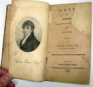
Rare 1803 Thomas Moore Odes of Anacreon 1st Edition Lodon PrintingLuis Porretta Fine Arts4.3(10)See Sold PriceMar 02, 2024
THOMAS CAMPBELL Pleasures of Hope First Edition 1st 1820 Poetry Calf BindingLuis Porretta Fine Arts4.3(10)See Sold PriceMar 02, 2024
DAVID ROBERTS - Holy Land / Syria / Egypt etc. 3 x Folio Volumes 1849 Very RareLuis Porretta Fine Arts4.3(10)See Sold PriceMar 02, 2024
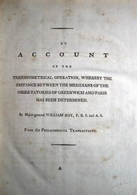
WILLIAM ROY Rare Navigation Book c1797 Trigonometry Between Paris & GreenwichLuis Porretta Fine Arts4.3(10)See Sold PriceMar 02, 2024
OFFER VAN ABRAHAM Book Of Genesis in Engravings c1700 Amsterdam Very rare!Luis Porretta Fine Arts4.3(10)See Sold PriceMar 02, 2024
MARTINET / DE VRIES Catechism of Nature 4 Vol. Set c1788 Engravings Rare!Luis Porretta Fine Arts4.3(10)See Sold PriceMar 02, 2024
Weavers Boy Poems by Chauncy Hare Townsend 1825 Calf BindingLuis Porretta Fine Arts4.3(10)See Sold PriceMar 02, 2024
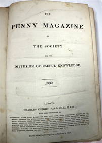
PENNY MAGAZINE 1832 & 1833 Full Bound Volumes Calf Binding THE PENNY MAGAZINELuis Porretta Fine Arts4.3(10)See Sold PriceMar 02, 2024
JAN VAN DER DESYATER c1732 First Edition Thoughts On Sleepless Nights Rare!Luis Porretta Fine Arts4.3(10)See Sold PriceMar 02, 2024
Josiah HENSCHELL c1828 Engraving Quay At Ramsgate Kent FramedLuis Porretta Fine Arts4.3(10)See Sold PriceMar 02, 2024
DUNLEVIE c1856 Map Counties Of Gaspe & Bonaventure Quebec Canada SCARCE! #2Luis Porretta Fine Arts4.3(10)See Sold PriceMar 02, 2024
DEVINE c1856 Dr Salters Map Of Lake Huron Ontario Indian Lands etc. No. 7 ScarceLuis Porretta Fine Arts4.3(10)See Sold PriceMar 02, 2024
MATTHEWS c1856 Map Of Upper Canada Ontario Indian Land Agency Divisions Scarce!Luis Porretta Fine Arts4.3(10)See Sold PriceMar 02, 2024
DUNLEVIE c1856 Map Counties Of Gaspe & Bonaventure Quebec Canada SCARCE! #1Luis Porretta Fine Arts4.3(10)See Sold PriceMar 02, 2024
Joseph Martin Kronheim Pair Early Color Glamor Prints c1850Luis Porretta Fine Arts4.3(10)See Sold PriceMar 02, 2024
THOMAS KEMPIS Imitation Of Christ c1890 Superb BindingLuis Porretta Fine Arts4.3(10)See Sold PriceMar 02, 2024
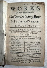
CHARLES SEDLEY BART Works In Prose c1722 1st Edition Full Calf SCARCE!Luis Porretta Fine Arts4.3(10)See Sold PriceMar 02, 2024
1738 BIBLE in DUTCH ILLUSTRATED w/ MAPS MASSIVE FOLIO in DUTCH antique BIBLIAJasper524.5(9.9k)See Sold PriceFeb 27, 2024
1730 BIBLE in DUTCH ILLUSTRATED w/ MAPS antique MASSIVE FOLIO BIBLIAJasper524.5(9.9k)See Sold PriceFeb 27, 2024


![A Collection [4] of Maps - Engravings of the Land of (1 of 4)](https://p1.liveauctioneers.com/2398/106082/54328088_1_x.jpg?height=282&quality=70&version=1499076176)