ATLAS of ANTIENT GEOGRAPHY by SAMUEL BUTLER 1843John McInnis Auctioneers,LLC4.6(502)See Sold PriceFeb 24, 2024
18TH C. ANTIQUE MAP: FRENCH & INDIAN WAR, FRAMEDThomaston Place Auction Galleries4.4(386)See Sold PriceFeb 24, 2024
Rand McNally Railroad Map Cabinet w/ 21 Railroad MapsRail & Road Auctions4.6(165)See Sold PriceMar 08, 2024
Keith Haring - Ink on New York Map, Best Buddies, Inscribed, Signed, and DatedSapphire Auction Gallery4(67)See Sold PriceMar 02, 2024
LATE 17TH C. FRENCH MAP OF THE NEW WORLD BY ALEXIS-HUBERT JAILLOT (1632-1712)Thomaston Place Auction Galleries4.4(386)See Sold PriceFeb 24, 2024
Central Railroad of New Jersey Map of Sandy Hook Route-ca. 1903JM Hobby Supply and Railroad Artifact Auctions4.4(126)See Sold PriceFeb 24, 2024
Lot of Six Mixed Atlas Box Cars-HO Scale-New in BoxJM Hobby Supply and Railroad Artifact Auctions4.4(126)See Sold PriceFeb 25, 2024
Rand McNally/Santa Fe Railroad Map of Iowa-1912JM Hobby Supply and Railroad Artifact Auctions4.4(126)See Sold PriceFeb 24, 2024
NICOLAES VISSCHER (NETHERLANDS, 1618-1709) MAP OF THE NEW WORLDThomaston Place Auction Galleries4.4(386)See Sold PriceFeb 24, 2024
17TH C. WORLD MAP BY NICOLAES VISSCHER (NETHERLANDS, 1618-1709)Thomaston Place Auction Galleries4.4(386)See Sold PriceFeb 24, 2024
Lot of Six Mixed Atlas Cabooses-HO Scale-New in BoxJM Hobby Supply and Railroad Artifact Auctions4.4(126)See Sold PriceFeb 25, 2024
SoldSDUK: North Africa in 5 sheetsMap Title: North Africa or Barbary I – V Cartographer: Baldwin & Cradock, Society for the Diffusion of Useful Knowledge Place/Date: London / 1836/1852 Size: 15 1/4" x 12 1/2" Condition: b&w; overallSee Sold Price
SoldSDUK: Ancient North Africa / Mediterranean (2 sheets)Title/Content of Map: SDUK: Ancient North Africa / Mediterranean (2 sheets) Date Printed: 1840/1852, London Cartographer: Society for the Diffusion of Useful Knowledge Size: 15 1/4" x 12 3/8" (each maSee Sold Price
SDUK: Ancient North Africa in 2 sheetsTitle: Ancient Africa or Libya, parts I and II Cartographer: Society for the Diffusion of Useful Knowledge Place/Date: London / 1840/1852Size: 15 1/4" x 12 3/8" (each map) Condition: b&w, overall ageSee Sold Price
SDUK: Ancient North Africa / Mediterranean in 2 sheetsTitle/Content of Map: SDUK: Ancient North Africa / Mediterranean in 2 sheets Date Printed: 1840/1852, London Cartographer: Society for the Diffusion of Useful Knowledge Size: 15 1/4" x 12 3/8" (each mSee Sold Price
SDUK: Ancient North Africa / Mediterranean in 2 sheetsA set of two highly detailed and informative maps of ancient northern Africa from the SDUK atlas. The first map encompasses the territory from Mauritania (modern Morocco) to modern-day Tunisia. The seSee Sold Price
SoldNatural History - Large Crinoid Fossil Display PlateSilurian Period, 443-416 million years B.P.. Presenting a large Scyphocrinus elegans crinoid, in an amorphous sheet matrix. 5.6 kg, 35 cm (13 3/4 in.). From Morocco, North Africa. [No Reserve]See Sold Price
SoldROBERT CAPA - Soldier in North Africa, WWIIArtist: ROBERT CAPA Print Title: Soldier in North Africa, WWII Medium: Sheet-fed Gravure Printing Date: 1960's Printed in Italy Image Size approx: 10 x 9.5 inches Robert Capa (1913-1954) was a HungariSee Sold Price
SoldROBERT CAPA - Nazi Graveyard, North AfricaArtist: ROBERT CAPA Print Title: Nazi Graveyard, North Africa Medium: Sheet-fed Gravure Printing Date: 1960's Printed in Italy Image Size approx: 9 x 12.5 inches Robert Capa (1913-1954) was a HungariaSee Sold Price
ROBERT CAPA - Soldier in North Africa, WWIIArtist: ROBERT CAPA Print Title: Soldier in North Africa, WWII Medium: Sheet-fed Gravure Printing Date: 1960's Printed in Italy Image Size approx: 9.5 x 10 inches Robert Capa (1913-1954) was a HungariSee Sold Price
SoldLehnert & Landrock: Tozeur OasisMedium: Sheet fed Copperplate Gravure Date: 1924 Printed in Berlin Image Size: 8 x 5.5 inches Lehnert & Landrock is the name of a photographic duo active during the early 20th century in North Africa.See Sold Price
Sold8 color maps: Asia & Africa, 19th C.[Africa]. 8 color maps. ++ 5 from Colton Atlas, c.1855. 14 1/4 x 11 1/8. Includes: 2 titled Africa: North Western Sheet; and 3 titled Africa: North Eastern Sheet. ++ Other 3 from Johnson's Family AtlaSee Sold Price
SDUK: Antique Map of North Ireland, 1845Title/Content of Map: 'IRELAND, North Sheet' List of round towers Cloigtheach Cloigthithe. Date Printed: 1845 Image Size: Approx 34.5 x 50.0cm, 13.5 x 19.75 inches (Large); Please note that this is aSee Sold Price
SoldSDUK New England 1832“North America/ Sheet VI/ New-York, Vermont, Maine, New-Hampshire, Massachusetts, Connecticut, Rhode-Island, and New-Jersey.” London: Society for the Diffusion of Useful Knowledge, 1832. 13 5/8 xSee Sold Price
SDUK: Antique Map of Lake Superior, 1846Title/Content of Map: 'NORTH AMERICA, SHEET lV., Lake Superior' Canada USA Ontario Michigan. Fur trading posts. Date Printed: 1846 Image Size: Approx 33.5 x 41.0cm, 13.25 x 16 inches (Large) Type: AntSee Sold Price
SDUK: Antique Map of Northeast United States, 1846TITLE/CONTENT OF MAP: 'NORTH AMERICA, SHEET VI., New York, Vermont, Maine, New Hampshire, Massachusetts, Connecticut, Rhode Island, New Jersey' DATE PRINTED: 1846 IMAGE SIZE: Approx 36.5 x 33.5cm, 14.See Sold Price
SDUK: Antique Map of Lake Superior, Canada, 1846Title/Content of Map: 'NORTH AMERICA, SHEET lV., Lake Superior' Canada USA Ontario Michigan. Fur trading posts. Date Printed: 1846 Image Size: Approx 33.5 x 41.0cm, 13.25 x 16 inches (Large) Type: AntSee Sold Price
SDUK: Antique Map of Ohio with parts of Kentucky, 1846TITLE/CONTENT OF MAP: 'NORTH AMERICA, SHEET VIII., Ohio, with parts of Kentucky and Virginia' DATE PRINTED: 1846 IMAGE SIZE: Approx 39.5 x 34.0cm, 15.5 x 13.5 inches (Large) TYPE: Antique steel engravSee Sold Price
SDUK: Antique Map of Ohio, 1846Title/Content of Map: 'NORTH AMERICA, SHEET VIII., Ohio, with parts of Kentucky and Virginia' Date Printed: 1846 Image Size: Approx 39.5 x 34.0cm, 15.5 x 13.5 inches (Large) Type: Antique steel engravSee Sold Price
Sold64.) 1934-A Emergency Currency North Africa 5$ Note64.) 1934-A Emergency Currency North Africa 5$ NoteSee Sold Price
SoldYellow Seal 1934-A North Africa $5 Silver CertificateWinner shall receive the exact currency shown here. (IS/RB)See Sold Price
Sold1934 a north Africa $5 yellow seal star note fr #23071934 a north Africa $5 yellow seal star note fr #2307 VG to F Rare!See Sold Price
SDUK North Africa or Barbary V. Tripoli and Egypt.“North Africa or Barbary V. Tripoli and Egypt.” London: SDUK, 1837. 12 1/2 x 15 3/8. Engraving. Original outline hand-coloring. Very good condition. Please note that this lot has a confidential reSee Sold Price
Sold4 African Metal Bracelets and Anklet. 20th c.A group of four African metal bracelets and anklet. ++ Alloyed metal anklet. West Africa. 3 1/2" x 3 1/2" x 5 1/2". ++ Brass Islamic style bracelet. North Africa. 5/8" x 2 3/4" x 6" (Circumference witSee Sold Price
SoldStone Age Polished Axehead GroupNeolithic, 6th-4th millennium BC. A group of five polished stone axeheads. 368 grams total, 68-94mm (2 3/4 - 3 3/4"). Previously from an old German collection; probably from North Africa. [5, No ReserSee Sold Price
Morocco, Algeria, Tunisia & Libya. North Africa. HUGHES 1876 old antique mapJasper524.5(9.8k)See Sold PriceFeb 28, 2024
NORTH AFRICA OF BABRBARY V Parts of Tripoli & Egypt. Libya Tribes. SDUK 1846 mapJasper524.5(9.8k)See Sold PriceFeb 28, 2024
COLONIAL FRENCH NORTH AFRICA. Afrique du Nord. Politique. Political 1929 mapJasper524.5(9.8k)See Sold PriceFeb 28, 2024
West Africa. Liberia Sahara Senegambia Guinea. Mountains of Kong COLTON 1869 mapJasper524.5(9.8k)See Sold PriceFeb 28, 2024
North west Africa. Liberia inset. Sahara Senegambia Guinea. COLTON 1863 mapJasper524.5(9.8k)See Sold PriceFeb 28, 2024
MAGHREB. North Africa Morocco Algeria & Tunisia. JOHNSTON 1913 old antique mapJasper524.5(9.8k)See Sold PriceFeb 28, 2024
Algeria Morocco & Tunis. North Africa. Tunisia. Maghreb. BARTHOLOMEW 1898 mapJasper524.5(9.8k)See Sold PriceFeb 28, 2024
NORTH AFRICA BARBARY. Parts of Tripoli (Libya) & Egypt. Tribes. SDUK 1844 mapJasper524.5(9.8k)See Sold PriceFeb 28, 2024
NORTH AFRICA. 'Biledulgerid', a former North African country. MALLET 1683 mapJasper524.5(9.8k)See Sold PriceFeb 28, 2024
NORTH AFRICA BARBARY. Parts of Tripoli (Libya) & Egypt. Tribes. SDUK 1844 mapJasper524.5(9.8k)See Sold PriceFeb 28, 2024
NORTH AFRICA OF BABRBARY V Parts of Tripoli & Egypt. Libya Tribes. SDUK 1851 mapJasper524.5(9.8k)See Sold PriceFeb 28, 2024
MAGHREB. North Africa. Marocco Algeria and Tunis. BLACKIE 1886 old antique mapJasper524.5(9.8k)See Sold PriceFeb 28, 2024
NORTH AFRICA. Morocco Algeria Tunis Tunisia Egypt. Cairo. BARTHOLOMEW 1901 mapJasper524.5(9.8k)See Sold PriceFeb 28, 2024
NORTH AFRICA. Barbary. Morocco Tunisia Libya Egypt. 'Barbarie'. MALLET 1683 mapJasper524.5(9.8k)See Sold PriceFeb 28, 2024
NORTH AFRICA. Morocco Tunisia Libya. 'Mauritanie'. Malta Melita. MALLET 1683 mapJasper524.5(9.8k)See Sold PriceFeb 28, 2024
NORTH AFRICA BARBARY. Parts of Tripoli (Libya) & Egypt. Tribes. SDUK 1848 mapJasper524.5(9.8k)See Sold PriceFeb 28, 2024
ANCIENT NORTH AFRICA Septentrionalis. Mauretania Tripolitana ARROWSMITH 1828 mapJasper524.5(9.8k)See Sold PriceFeb 28, 2024
AFRICA. French North Africa and Morocco 1907 old antique map plan chartJasper524.5(9.8k)See Sold PriceFeb 28, 2024
NORTH AFRICA. Algeria Morocco Tunis Tunisia Maghreb. BARTHOLOMEW 1891 old mapJasper524.5(9.8k)See Sold PriceFeb 28, 2024
MAGHREB. North Africa. Marocco Algeria and Tunis. BLACKIE 1882 old antique mapJasper524.5(9.8k)See Sold PriceFeb 28, 2024
West Africa. Sahara caravan routes. Tribes Kingdoms Empires. LIZARS 1842 mapJasper524.5(9.8k)See Sold PriceFeb 28, 2024
Afrique Ancienne. Ancient North Africa. MALTE-BRUN c1871 old antique map chartJasper524.5(9.8k)See Sold PriceFeb 28, 2024
AN EARLY SILVER SNUFF BOX. Probably Morocco or North Africa, c.1900. Engraved with a Jewish star andJ. Greenstein & Co., Inc.4.3(55)See Sold PriceApr 16, 2024
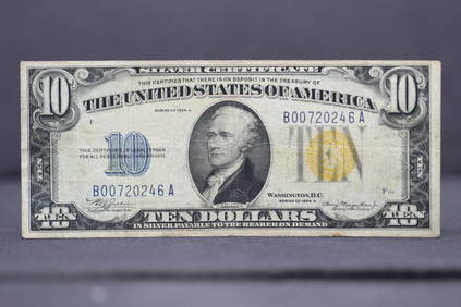
1934-A $10 Silver Certificate Note - North Africa Yellow Seal Lower S.N. James Bond 007Richard L. Edwards Auctioneering4.8(2.3k)See Sold PriceFeb 26, 2024