ATLAS of ANTIENT GEOGRAPHY by SAMUEL BUTLER 1843John McInnis Auctioneers,LLC4.5(505)See Sold PriceFeb 24, 2024
18TH C. ANTIQUE MAP: FRENCH & INDIAN WAR, FRAMEDThomaston Place Auction Galleries4.4(393)See Sold PriceFeb 24, 2024
Rand McNally Railroad Map Cabinet w/ 21 Railroad MapsRail & Road Auctions4.6(165)See Sold PriceMar 08, 2024
Keith Haring - Ink on New York Map, Best Buddies, Inscribed, Signed, and DatedSapphire Auction Gallery4(67)See Sold PriceMar 02, 2024
LATE 17TH C. FRENCH MAP OF THE NEW WORLD BY ALEXIS-HUBERT JAILLOT (1632-1712)Thomaston Place Auction Galleries4.4(393)See Sold PriceFeb 24, 2024
Central Railroad of New Jersey Map of Sandy Hook Route-ca. 1903JM Hobby Supply and Railroad Artifact Auctions4.4(127)See Sold PriceFeb 24, 2024
Lot of Six Mixed Atlas Box Cars-HO Scale-New in BoxJM Hobby Supply and Railroad Artifact Auctions4.4(127)See Sold PriceFeb 25, 2024
Rand McNally/Santa Fe Railroad Map of Iowa-1912JM Hobby Supply and Railroad Artifact Auctions4.4(127)See Sold PriceFeb 24, 2024
NICOLAES VISSCHER (NETHERLANDS, 1618-1709) MAP OF THE NEW WORLDThomaston Place Auction Galleries4.4(393)See Sold PriceFeb 24, 2024
17TH C. WORLD MAP BY NICOLAES VISSCHER (NETHERLANDS, 1618-1709)Thomaston Place Auction Galleries4.4(393)See Sold PriceFeb 24, 2024
Lot of Six Mixed Atlas Cabooses-HO Scale-New in BoxJM Hobby Supply and Railroad Artifact Auctions4.4(127)See Sold PriceFeb 25, 2024
SoldNorth America Sheet I Nova Scotia With Part of NewReserve Reduced! Title: North America Sheet I Nova Scotia With Part of New Brunswick and East Canada Publication Date: 1860 Cartographer: STANFORD, EDWARD Publisher: EDWARD STANFORD/S.D.U.K. Size (incSee Sold Price
North America Sheet I. Nova Scotia With Part of NewTitle: North America Sheet I. Nova Scotia With Part of New Brunswick and Lower Canada Publication Date: 1832 Cartographer: WALKER, J. & C. Publisher: Baldwin & Cradock/S.D.U.K. Dimension: 15.3 X 12 DeSee Sold Price
North America Sheet I Nova-Scotia With Part of NewPublication Date: 1852 Title: North America Sheet I Nova-Scotia With Part of New Brunswick and Lower Canada Cartographer: Society for the Diffusion of Useful Knowledge/ S.D.U.K. | J. & C. Walker PubliSee Sold Price
SDUK: Antique Map of Nova Scotia, Canada, 1846TITLE/CONTENT OF MAP: 'NORTH AMERICA, SHEET I., NOVA SCOTIA WITH PART OF NEW BRUNSWICK AND LOWER CANADA' Quebec Prince Edward's Island. Canada. DATE PRINTED: 1846 IMAGE SIZE: Approx 41.0 x 33.5cm, 16.See Sold Price
Sold11 maps of portions of North America by the SDUKTitle: Eleven maps of portions of North America by the SDUK Author: Society for the Diffusion of Useful Knowledge Description: Includes: North America: Sheet I, Nova-Scotia with part of New BrunswickSee Sold Price
SoldNOVA SCOTIA.& New Brunswick Quebec Prince Edward'sTITLE/CONTENT OF MAP: 'NORTH AMERICA, SHEET I., NOVA SCOTIA WITH PART OF NEW BRUNSWICK AND LOWER CANADA' The top image on the right hand side shows the entire map. To view a close up of the map showinSee Sold Price
SDUK: Antique Map of Nova Scotia & New Brunswick, 1844Title/Content of Map: 'NORTH AMERICA, SHEET I., NOVA SCOTIA WITH PART OF NEW BRUNSWICK AND LOWER CANADA' Quebec Prince Edward's Island. Date Printed: This map was originally published by Baldwin & CraSee Sold Price
SDUK: Antique Map of Nova Scotia, 1846Title/Content of Map: 'NORTH AMERICA, SHEET I., NOVA SCOTIA WITH PART OF NEW BRUNSWICK AND LOWER CANADA' Date Printed: 1846 Image Size: Approx 41.0 x 33.5cm, 16.25 x 13.25 inches (Large) Type: AntiqueSee Sold Price
11 maps of portions of North America by the SDUKTitle: Eleven maps of portions of North America by the SDUK Author: Society for the Diffusion of Useful Knowledge Description: Includes: North America: Sheet I, Nova-Scotia with part of New BrunswickSee Sold Price
Edward Stanford, British 1827-1904- ''North America,Edward Stanford, British 1827-1904- ''North America, Sheet I, Nova-Scotia, with Part of New Brunswick and East Canada'' publ. Baldwin and Cradock of Paternoster Row for the Society for the Diffusion oSee Sold Price
SDUK: Antique Map of Nova Scotia, Canada, 1846TITLE/CONTENT OF MAP: 'NORTH AMERICA, SHEET I., NOVA SCOTIA WITH PART OF NEW BRUNSWICK AND LOWER CANADA' Quebec Prince Edward's Island. Canada. DATE PRINTED: 1846 IMAGE SIZE: Approx 41.0 x 33.5cm, 16.See Sold Price
Map of N. America, Nova Scotia & Newfoundland, 1796Map: Part of North America, Containing Canada, the North Parts of New England and New York; With Nova Scotia And Newfoundland Publication Date: 1796 Authors: ANONYMOUS Size: Quarto – 8.30 H x 11.30See Sold Price
New Brunswick Nova ScotiaTitle: New Brunswick Nova Scotia Publication Date: 1890 Cartographer: RAND, MCNALLY & CO. Publisher: JOHN B. ALDEN Dimension: 12.75 X 19.5 56, 57.On obverse part of North America, onreverse, western CSee Sold Price
Three Maps by U. S. Coast Surveys, the first "NorthThree Maps by U. S. Coast Surveys, the first "North East Coast of North America, Nova Scotia to New Jersey," 1878, H. - 29 in., W. - 38 3/8 in.; the second "Hudson River from Albany to New Baltimore,"See Sold Price
SoldGeographical View of British Possessions in NorthHeading: Author: Smith, Michae Title: A Geographical View of the British Possessions in North America: comprehending , Nova Scotia, New Brunswick, New Britain, Lower and Upper Canada With all the CouSee Sold Price
Map of Upper CanadaMap of Upper Canada, North America Sheet III with parts of New York, Pennsylvania & MIchigan, published by the Soceity for Diffusion of Useful Knowledge, very good codnition. 12 1/4 x 16 1/2''See Sold Price
North America Sheet III West Canada With Parts of NewReserve Reduced! Title: North America Sheet III West Canada With Parts of New York, Pennsylvania and Michigan Publication Date: 1860 Cartographer: WALKER, J. & C. Publisher: EDWARD STANFORD/S.D.U.K. SSee Sold Price
North America Sheet III Upper Canada With Parts ofTitle: North America Sheet III Upper Canada With Parts of New-York, Pennsylvania and Michigan. Date: 1852 Cartographer: Society for the Diffusion of Useful Knowledge/ S.D.U.K. | J. & C. Walker PublishSee Sold Price
SDUK New York State & Upper Canada“North America Sheet III Upper Canada with Parts of New York, Pennsylvania and Michigan.” London: Baldwin & Gradock, 1832. 12 1/2 x 16 1/2.. Engraving by J.&C. Walker. Original outline color. VerySee Sold Price
SoldROGERS, HENRY D., and JOHNSTON, A. KEITH. AtlaROGERS, HENRY D., and JOHNSTON, A. KEITH. Atlas of the United States of North America, Canada, New Brunswick, Nova Scotia, Newfoundland, Mexico, Central America, Cuba, and Jamaica. 29 mapsheets, mostSee Sold Price
SoldDarwin & Johnston's Atlas of United States 1857Heading: Author: Rogers, Henry Darwin & A. Keith Johnston Title: Atlas of the United States of North America, Canada, New Brunswick, Nova Scotia, Newfoundland, Mexico, Central America, Cuba, and JamaSee Sold Price
Sold[North America]. Bellin, N. A New Chart[North America]. Bellin, N. A New Chart Of The Coast Of New England, Nova Scotia New France Or Canada, With The Islands Of Newfoundld. Cape Breton St. John's &c. [**Gentleman's Magazine,** V.16, FebruSee Sold Price
Buckingham, “Canada, Nova Scotia, New Brunswick,”Title: Canada, Nova Scotia, New Brunswick, And The Other British Provinces In North America, With A Plan Of National Colonization. Author: James Buckingham. Published by Fisher & Son, London: 1843. 54See Sold Price
Canada - Canada, Nova Scotia, New Brunswick, and...Canada - Canada, Nova Scotia, New Brunswick, and the other British Provinces in North America with a plan of National Colonization Book - By James S. Buckingham. First Edition. Fisher, London [1843].See Sold Price
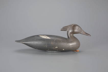
The McAlpin Horner Merganser Hen Decoy by Nathan Rowley Horner (1882-1942)Copley Fine Art Auctions4.5(40)See Sold PriceFeb 24, 2024
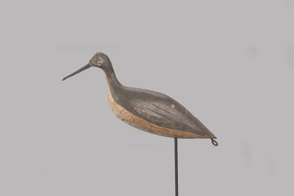
The Johnson Johnson Yellowlegs Decoy by J. Taylor Johnson (1853-1929)Copley Fine Art Auctions4.5(40)See Sold PriceFeb 24, 2024
LATE 18TH C. VERY LARGE CHART OF NORTHEAST CANADA BY DES BARRES (1721-1824), 1780, FRAMEDThomaston Place Auction Galleries4.4(393)See Sold PriceFeb 24, 2024
LARGE EARLY 18TH C. DUTCH CHART OF UPPER NORTH AMERICA, PIERRE MORTIER (1661-1711), FRAMEDThomaston Place Auction Galleries4.4(393)See Sold PriceFeb 24, 2024
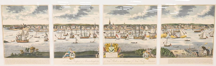
A South Prospect of Ye Flourishing City of New York in the Province of New York, North AmericaNadeau's Auction Gallery4.7(409)See Sold PriceFeb 24, 2024
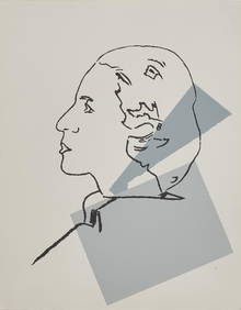
Andy Warhol (American, 1928-1987) - Diane Vreeland in ProfileFreeman's | Hindman4.5(158)See Sold PriceFeb 28, 2024
BIRDS OF NORTH AMERICA 2001 New Condition 1008 pgs.North American Artifact Auctions4.7(198)See Sold PriceApr 20, 2024
Audubon's Quadrupeds of North America 1989 NEW or FINE Condition Folio SizeNorth American Artifact Auctions4.7(198)See Sold PriceApr 20, 2024
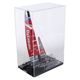
Abordage Official Emirates Team NZ Ship Desk ModelHill Auction Gallery 4.7(1k)See Sold PriceFeb 28, 2024
[SHIPWRECKS]. Manuscript testimony (court duplicate) of Thomas Kent, a Black man aboard theFreeman's | Hindman4.4(1.6k)See Sold PriceFeb 27, 2024
Audubon - 8 Quadruped LithographsTrillium Antique Prints & Rare Books4.5(32)See Sold PriceFeb 24, 2024
Audubon, Imperial Folio - 4 Lithographs of Squirrel, Rat, MiceTrillium Antique Prints & Rare Books4.5(32)See Sold PriceFeb 24, 2024
Audubon, Imperial Folio - American Cross Fox. 6Trillium Antique Prints & Rare Books4.5(32)See Sold PriceFeb 24, 2024
Audubon, Imperial Folio - Canada Lynx. 16Trillium Antique Prints & Rare Books4.5(32)See Sold PriceFeb 24, 2024
1698 BIBLE NEW TESTAMENT Novum testamentum antique VELLUM BOUND MASSIVE FOILOJasper524.5(9.9k)See Sold PriceFeb 27, 2024
New and Correct Map of North America With the West India Islands,Jasper524.5(9.9k)See Sold PriceFeb 27, 2024
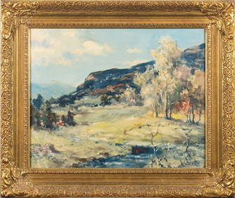
American Impressionist Original Oil Painting The Creek in Spring, framed c. 1950'sJasper524.5(9.9k)See Sold PriceFeb 28, 2024
West Africa. Sahara caravan routes. Tribes Kingdoms Empires. LIZARS 1842 mapJasper524.5(9.9k)See Sold PriceFeb 28, 2024
Herman Moll A New Map of Ye North Parts of AmericaWillow Auction House4.5(289)See Sold PriceMar 14, 2024


![[North America]. Bellin, N. A New Chart (1 of 1)](https://p1.liveauctioneers.com/179/1435/617517_1_x.jpg?height=282&quality=70)


![[SHIPWRECKS]. Manuscript testimony (court duplicate) of Thomas Kent, a Black man aboard the (1 of 5)](https://p1.liveauctioneers.com/197/319238/171468014_1_x.jpg?height=282&quality=70&version=1707520367)