MATTHEWS c1856 Map Of Upper Canada Ontario Indian Land Agency Divisions Scarce!Luis Porretta Fine Arts4.3(10)See Sold PriceMar 02, 2024
DEVINE c1856 Dr Salters Map Of Lake Huron Ontario Indian Lands etc. No. 7 ScarceLuis Porretta Fine Arts4.3(10)See Sold PriceMar 02, 2024
DUNLEVIE c1856 Map Counties Of Gaspe & Bonaventure Quebec Canada SCARCE! #1Luis Porretta Fine Arts4.3(10)See Sold PriceMar 02, 2024
DUNLEVIE c1856 Map Counties Of Gaspe & Bonaventure Quebec Canada SCARCE! #2Luis Porretta Fine Arts4.3(10)See Sold PriceMar 02, 2024
Map UNITED COUNTIES LEEDS & GRENVILLE by Walling 1861 Rare Canada Map 5ft x 5ftLuis Porretta Fine Arts4.3(10)See Sold PriceMar 02, 2024
Ambroise TARDIEU c1822 Map Venice Napoleon Italian Campaign 17" x 11"Luis Porretta Fine Arts4.3(10)See Sold PriceMar 02, 2024
SDUK: Antique Map of Nova Scotia, Canada, 1846TITLE/CONTENT OF MAP: 'NORTH AMERICA, SHEET I., NOVA SCOTIA WITH PART OF NEW BRUNSWICK AND LOWER CANADA' Quebec Prince Edward's Island. Canada. DATE PRINTED: 1846 IMAGE SIZE: Approx 41.0 x 33.5cm, 16.See Sold Price
SDUK: Antique Map of Nova Scotia, Canada, 1846TITLE/CONTENT OF MAP: 'NORTH AMERICA, SHEET I., NOVA SCOTIA WITH PART OF NEW BRUNSWICK AND LOWER CANADA' Quebec Prince Edward's Island. Canada. DATE PRINTED: 1846 IMAGE SIZE: Approx 41.0 x 33.5cm, 16.See Sold Price
SDUK: Antique Map of Nova Scotia, 1846Title/Content of Map: 'NORTH AMERICA, SHEET I., NOVA SCOTIA WITH PART OF NEW BRUNSWICK AND LOWER CANADA' Date Printed: 1846 Image Size: Approx 41.0 x 33.5cm, 16.25 x 13.25 inches (Large) Type: AntiqueSee Sold Price
SDUK: Antique Map of Nova Scotia & New Brunswick, 1844Title/Content of Map: 'NORTH AMERICA, SHEET I., NOVA SCOTIA WITH PART OF NEW BRUNSWICK AND LOWER CANADA' Quebec Prince Edward's Island. Date Printed: This map was originally published by Baldwin & CraSee Sold Price
SDUK: Antique Map of Lake Superior, Canada, 1846Title/Content of Map: 'NORTH AMERICA, SHEET lV., Lake Superior' Canada USA Ontario Michigan. Fur trading posts. Date Printed: 1846 Image Size: Approx 33.5 x 41.0cm, 13.25 x 16 inches (Large) Type: AntSee Sold Price
Sold18th C Italian Map of Eastern Canada Antonio Zatta1778 Antonio Zatta Antique Map of Nova Scotia and Labrador Canada. Original title Parte Orientale del Canada, Nuova Scozia Settentrionale, e Parte di Labrador. From Atlante Novissimo. Measures 12.5 inSee Sold Price
Thomson: Antique Map of Canada & Nova Scotia, 1817Map: Canada and Nova Scotia. Publication Date: 1817 Authors: JOHN THOMSON, JUNR. & CO., THOMSON, JOHN & CO. Publisher: JOHN THOMSON, JUNR. & CO. Size: Double Folio – 19.00 H x 23.30 W Inches No.43 (See Sold Price
Thomson: Antique Map of Canada & Nova Scotia, 1817Title/Content of Map: 'Canada and Nova Scotia [or British dominions in America]' The New Brunswick / Maine border predates the Aroostook War of 18381839, as a result of which the present border was seSee Sold Price
SoldThomson: Antique Map of Canada & Nova Scotia, 1814Map: Canada and Nova Scotia Cartographer: Thomson Place & Date: Edinburgh / 1814/1817 Size: 23 3/4" x 19 1/8" Condition: wash color; light browning and minor staining in margins The superbly detailedSee Sold Price
Thomson: Antique Map of Canada & Nova Scotia, 1817TITLE/CONTENT OF MAP: 'Canada and Nova Scotia [or British dominions in America]' British North America The New Brunswick / Maine border predates the Aroostook War of 18381839, as a result of which theSee Sold Price
Thomson: Antique Map of Canada & Nova Scotia, 1817TITLE/CONTENT OF MAP: 'Canada and Nova Scotia [or British dominions in America]' The New Brunswick / Maine border predates the Aroostook War of 18381839, as a result of which the present border was seSee Sold Price
SDUK: Antique Map of Upper Canada & Great Lakes, 1846Title/Content of Map: 'NORTH AMERICA, SHEET III., Upper Canada and New Brunswick with parts of New York, Pennsylvania and Michigan' The map shows the historic districts of Upper Canada (Ontario) as thSee Sold Price
SoldThomson: Antique Map of Canada & Nova Scotia, 1817Title/Content of Map: Canada and Nova Scotia. Date Printed: 1817 Cartographer: THOMSON, JOHN & CO. Size (inches): 16.1x22 No.43 (unnumbered) from Thomson's New General Atlas 1817. W. Dassauville engr.See Sold Price
SDUK: Antique Map of the Great Lakes, Canada, 1846Title/Content of Map: 'NORTH AMERICA, SHEET III., Upper Canada and New Brunswick with parts of New York, Pennsylvania and Michigan'. The map shows the historic districts of Upper Canada (Ontario) as tSee Sold Price
SoldBellin: Antique Map of Canada Arcadia Nova Scotia, 1740Title/Content of Map: Canada. Arcadia. Or Nova Scotia Date Printed: c 1740-70's Cartographer: J.N. Bellin & J.F. La Harpe Material/Medium: Paper Size: 10" x 15" Copperplate engraved. Published in PariSee Sold Price
Thomson: Antique Map of Canada and Nova Scotia, 1817TITLE/CONTENT OF MAP: 'Canada and Nova Scotia [or British dominions in America]' The New Brunswick / Maine border predates the Aroostook War of 18381839, as a result of which the present border was seSee Sold Price
Bowen: Antique Map of Gulf of St. Lawerence, 1752Title: A New & Accurate Map of the Islands of Newfoundland, Cape Briton, St. John and Anticosta; Together with the Neighbouring Countries of Nova Scotia, Canada &c...1752 Bowen Gulf of St. Lawerence wSee Sold Price
SoldTallis / Rapkin: Antique Map Nova Scotia & NewfoundlandTitle/Content of Map: 'Nova Scotia and Newfoundland' Vignettes: Halifax, Nova Scotia; Cod Fishery off Newfoundland. Halifax view. Canada. PE. Date Printed: 1851 Image Size: Approx 36.5 x 26.5cm, 14.5See Sold Price
SoldBellin: Antique Map of St. Lawrence Gulf; Canada, 1745Partie orientale de la Nouvelle France ou Canada'. St Lawrence. The map shows the Gulf of St Lawrence including what are now the maritime provinces of Canada (Nova Scotia, New Brunswick, Newfoundland,See Sold Price
SoldBellin/Jefferys: Antique Map of Canada & Islands, 1746Map: A new chart of the coast of New England, Nova Scotia, New France or Canada, with the islands of Newfoundl’d. Cape Breton, St. John’s &c. Publication Date: 1746 Authors: Gentleman’s MagazineSee Sold Price
SoldColton: Antique Map of New Brunswick, Nova Scotia, 1861Title/Content of Map: Canada, New Brunswick, Nova Scotia and Newfoundland Date Printed: 1861 Cartographer: J.H. Colton Material/Medium: Paper Size: 17 1/4" x 13" Hand colored steel engraved Map from 'See Sold Price
SoldLower Canada, New Brunswick, Nova Scotia' Quebec &TITLE/CONTENT OF MAP: 'Lower Canada, New Brunswick, Nova Scotia &c.; Inset map of Newfoundland' DATE PRINTED: 1862 IMAGE SIZE: Approx 31.0 x 45.0cm, 12.25 x 17.75 inches (Large) TYPE: Antique map withSee Sold Price
Ettling: Antique Map of Lower Canada, 1863TITLE/CONTENT OF MAP: 'Lower Canada, New Brunswick, Nova Scotia &c.; Inset map of Newfoundland' DATE PRINTED: 1863 IMAGE SIZE: Approx 31.0 x 45.0cm, 12.25 x 17.75 inches (Large) TYPE: Antique map withSee Sold Price
Colton's North Eastern Canada MapCirca 1855 Antique Canada Map, Title: Colton's New Brunswick, Nova Scotia, Prince Edward Id., and Cape Breton Id. Published by: J. H. Colton of NY in 1855, Approximate size: 18-1/2" x 26". Map folds aSee Sold Price
William Boyle (Canada,MA,PA,1852-1928) oil painting antiqueBroward Auction Gallery4.8(277)See Sold PriceMar 17, 2024
LATE 18TH C. VERY LARGE CHART OF NORTHEAST CANADA BY DES BARRES (1721-1824), 1780, FRAMEDThomaston Place Auction Galleries4.4(386)See Sold PriceFeb 24, 2024
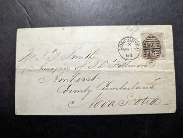
1863 England Cover London to Nova Scotia Canada QV SG#84 StampMynt Auctions4.6(680)See Sold PriceFeb 28, 2024
De Jode, Rare, pub. 1593 - Map of Italy (Italiae Totius Orbis olim Domatricis Nova ExactissTrillium Antique Prints & Rare Books4.5(30)See Sold PriceFeb 24, 2024
1772 GREEK BIBLE NEW TESTAMENT antique BIBLIA LATIN text MAP NOVUM TESTAMENTUMJasper524.5(9.8k)See Sold PriceFeb 27, 2024
GORDON GEZA MARICH, CANADIAN (1913 - 1985)Artingstall Auctioneers 18744.1(117)See Sold PriceFeb 25, 2024
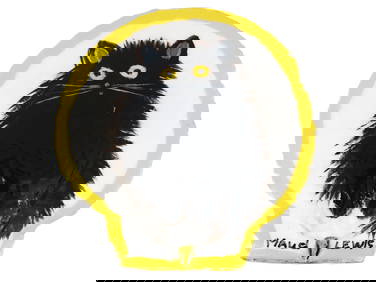
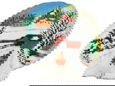
CANADIAN FOLK OIL PAINTING ON SHELL BY MAUD LEWISAntique Arena Inc.4.5(852)See Sold PriceMar 02, 2024
CANADIAN FOLK OIL PAINTING ON SHELL BY MAUD LEWISAntique Arena Inc.4.5(852)See Sold PriceMar 02, 2024
14" x 12" David Brooks 'Big Bear' Framed PrintWeatherham Estate Treasures3.9(157)See Sold PriceMar 21, 2024
WEST AFRICA Explorers' routes Senegal Ashanti. Mountains of Kong. SDUK 1857 mapJasper524.5(9.8k)See Sold PriceFeb 28, 2024
AFRICA. Map pre-dating much exploration. Mountains of Kong. SDUK 1851 oldJasper524.5(9.8k)See Sold PriceFeb 28, 2024
NORTH AFRICA OF BABRBARY V Parts of Tripoli & Egypt. Libya Tribes. SDUK 1846 mapJasper524.5(9.8k)See Sold PriceFeb 28, 2024
NORTH AFRICA BARBARY. Parts of Tripoli (Libya) & Egypt. Tribes. SDUK 1848 mapJasper524.5(9.8k)See Sold PriceFeb 28, 2024
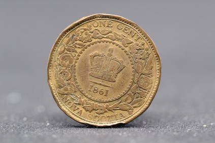
1832 Canada (Nova Scotia) Copper Half Penny Token AUGolden Gate Auctioneer4.1(273)See Sold PriceFeb 26, 2024
MICHAEL SNOW: COVER TO COVER. 1st ED. NSCAD, 1975Toronto Book Auctions4.3(13)See Sold PriceMar 07, 2024
SIGNED. LAWRENCE WEINER: POSTERS. 1ST. ED. 1987.Toronto Book Auctions4.3(13)See Sold PriceMar 07, 2024
1861-Nova Scotia- High Grade/Great Details, Canada One Cent, 163 years old!Richard L. Edwards Auctioneering4.8(2.3k)See Sold PriceFeb 27, 2024