ATLAS of ANTIENT GEOGRAPHY by SAMUEL BUTLER 1843John McInnis Auctioneers,LLC4.5(505)See Sold PriceFeb 24, 2024
18TH C. ANTIQUE MAP: FRENCH & INDIAN WAR, FRAMEDThomaston Place Auction Galleries4.4(393)See Sold PriceFeb 24, 2024
Rand McNally Railroad Map Cabinet w/ 21 Railroad MapsRail & Road Auctions4.6(165)See Sold PriceMar 08, 2024
Keith Haring - Ink on New York Map, Best Buddies, Inscribed, Signed, and DatedSapphire Auction Gallery4.1(67)See Sold PriceMar 02, 2024
LATE 17TH C. FRENCH MAP OF THE NEW WORLD BY ALEXIS-HUBERT JAILLOT (1632-1712)Thomaston Place Auction Galleries4.4(393)See Sold PriceFeb 24, 2024
Central Railroad of New Jersey Map of Sandy Hook Route-ca. 1903JM Hobby Supply and Railroad Artifact Auctions4.4(127)See Sold PriceFeb 24, 2024
Lot of Six Mixed Atlas Box Cars-HO Scale-New in BoxJM Hobby Supply and Railroad Artifact Auctions4.4(127)See Sold PriceFeb 25, 2024
Rand McNally/Santa Fe Railroad Map of Iowa-1912JM Hobby Supply and Railroad Artifact Auctions4.4(127)See Sold PriceFeb 24, 2024
NICOLAES VISSCHER (NETHERLANDS, 1618-1709) MAP OF THE NEW WORLDThomaston Place Auction Galleries4.4(393)See Sold PriceFeb 24, 2024
17TH C. WORLD MAP BY NICOLAES VISSCHER (NETHERLANDS, 1618-1709)Thomaston Place Auction Galleries4.4(393)See Sold PriceFeb 24, 2024
Lot of Six Mixed Atlas Cabooses-HO Scale-New in BoxJM Hobby Supply and Railroad Artifact Auctions4.4(127)See Sold PriceFeb 25, 2024
SoldLarge quantity of Ordnance Survey maps with variousLarge quantity of Ordnance Survey maps with various dates circa 1910 to '74See Sold Price
SoldA large quantity of Ordnance Survey maps 1933 - 1990'sA large quantity of Ordnance Survey maps 1933 - 1990's also maps by Bartholomew, Bacon etc. (approx. 120)See Sold Price
SoldA large quantity of ordnance survey maps, includingA large quantity of ordnance survey maps, including Peak District National Park examples.See Sold Price
SoldA quantity of folding ordnance survey maps, includingA quantity of folding ordnance survey maps, including examples by Bacon, Ward, Lock & Co., Gall & Inglis and Bartholomew. To include, Motoring and Touring Map of England, Map and Guide to London, HertSee Sold Price
SoldA quantity of assorted 20thC Ordnance Survey maps.A quantity of assorted 20thC Ordnance Survey maps.See Sold Price
SoldA quantity of 1960s One-Inch Ordnance Survey / OS maps,A quantity of 1960s One-Inch Ordnance Survey / OS maps, together with some older examples and some loose sheet maps.See Sold Price
SoldQuantity of Ordnance Survey and other folding maps,Quantity of Ordnance Survey and other folding maps, various road atlases, etcSee Sold Price
Sold– a good quantity of early 20th C. ORDNANCE SURVEY– a good quantity of early 20th C. ORDNANCE SURVEY MAPS, and a few other maps (Q).See Sold Price
SoldMaps : An quantity of Second World War Ordnance SurveyMaps : An quantity of Second World War Ordnance Survey maps of North Africa and the Middle East issued to the RAF. (8 maps) Please Note - we do not make reference to the condition of lots within catalSee Sold Price
SoldBox containing a quantity of various Ordnance SurveyBox containing a quantity of various Ordnance Survey and Bartholomew maps etc.See Sold Price
SoldMaps : A quantity of early to mid 20thC Ordnance SurveyMaps : A quantity of early to mid 20thC Ordnance Survey maps including British County maps for Gloucester, Middlesex etc., and for Ireland and America, Michelin French maps, a number of Air Force WarSee Sold Price
SoldBox containing a quantity of various 20th CenturyBox containing a quantity of various 20th Century Ordnance Survey road maps, various cloth cased road maps and various guides and ephemeraSee Sold Price
SoldSmall quantity of various die-cast metal modelSmall quantity of various die-cast metal model vehicles, together with a quantity of pens, a framed reproduction Ordnance Survey map and two Bakelite telephones etcSee Sold Price
SoldQuantity of early 20th Century ordnance surveys andQuantity of early 20th Century ordnance surveys and Bartholomews mapsSee Sold Price
SoldA quantity of assorted Oxford postcards, together withA quantity of assorted Oxford postcards, together with a 1921 ordnance survey map of Oxford, a coloured street plan of Oxford, a contoured road map of Oxford, and Wembley Exhibition Edition of Bacon'sSee Sold Price
SoldA large quantity of early to mid 20thC one inch to oneA large quantity of early to mid 20thC one inch to one miles Ordnance Survey maps of Great Britain, Wales and Scotland. Many War Office Editions. To include Buckingham, Banbury, Gainsborough, Sound ofSee Sold Price
SoldA quantity of assorted Oxford postcards, together withA quantity of assorted Oxford postcards, together with a 1921 ordnance survey map of Oxford, a coloured street plan of Oxford, a contoured road map of Oxford, and Wembley Exhibition Edition of Bacon'sSee Sold Price
SoldMaps : A quantity of mid to late 20thC illustrated mapsMaps : A quantity of mid to late 20thC illustrated maps and touring guides for the USA, Australia, Europe, Great Britain, including Bartholomew's guides and Ordnance Survey maps. (approx. 26) £25 - 3See Sold Price
SoldA quantity of assorted Oxford postcards, together withA quantity of assorted Oxford postcards, together with a 1921 ordnance survey map of Oxford, a coloured street plan of Oxford, a contoured road map of Oxford, and Wembley Exhibition Edition of Bacon'sSee Sold Price
SoldOrdnance Survey maps,South West England and Wales, late 19th century, double page coastal maps/charts, including Falmouth Harbour, Menai Strait 1464, Newquay to Holyhead 1411, Milford Haven, Bristol Channel 1179, TrevoseSee Sold Price
SoldEngland.- A group of 16 Ordnance Survey maps, mainlyEngland.- A group of 16 Ordnance Survey maps, including a Col. Mudge map of Kent showing Whitstable, Ramsgate and Dover, 4 Col. Colby maps sold by Letts, Son & Co. of Essex, Kent, Berkshire, and HampsSee Sold Price
SoldOrdnance Survey maps,West Coast of Scotland, late 19th century with some revisions, approx 60 sheets, some with vignettes, including Lochs, Western Isles, Skye, Harris, Hebrides etc, condition varies (c.60)See Sold Price
Nottingham.- Ordnance Survey Office (publisher) Collection 8 geological maps on the environs ofForum Auctions4.3(53)See Sold PriceFeb 29, 2024
INDIA WITHIN THE GANGES SUSAN GOLE ILLUSTRATED MAPS EARLY CARTOGRAPHYJasper524.5(9.9k)See Sold PriceFeb 27, 2024
ORDNANCE SURVEY OF IRELAND/ Sheet No. 79/ CAVAN, LEITRIM, LONGFORD, MEATH & WESTMEATH Revised 1899Churchill Galleries3.7(217)See Sold PriceFeb 26, 2024
ORDNANCE SURVEY OF IRELAND/ Sheet No. 80/ CAVAN, MEATH & MONAGHAN/ Surveyed 1837 - 39. Printed inChurchill Galleries3.7(217)See Sold PriceFeb 26, 2024
ORDNANCE SURVEY OF IRELAND/ Sheet No. 89/ LONGFORD, MEATH & WESTMEATH/ Published in 1903Churchill Galleries3.7(217)See Sold PriceFeb 26, 2024
ORDNANCE SURVEY OF IRELAND/ Sheet No. 89/ LONGFORD, MEATH & WESTMEATH/ Published in 1903Churchill Galleries3.7(217)See Sold PriceFeb 26, 2024
ORDNANCE SURVEY OF IRELAND/ Sheet No. 89/ LONGFORD, MEATH & WESTMEATH/ Published in 1903Churchill Galleries3.7(217)See Sold PriceFeb 26, 2024
ORDNANCE SURVEY OF IRELAND/ Sheet No. 89/ LONGFORD, MEATH & WESTMEATH/ Published in 1903Churchill Galleries3.7(217)See Sold PriceFeb 26, 2024
ORDNANCE SURVEY OF IRELAND/ Sheet No.90/ MEATH & WESTMEATH/ Published in 1903Churchill Galleries3.7(217)See Sold PriceFeb 26, 2024
ORDNANCE SURVEY OF IRELAND/ Sheet No.90/ MEATH & WESTMEATH/ Published in 1903Churchill Galleries3.7(217)See Sold PriceFeb 26, 2024
ORDNANCE SURVEY OF IRELAND/ Sheet No.90/ MEATH & WESTMEATH/ Published in 1903Churchill Galleries3.7(217)See Sold PriceFeb 26, 2024
ORDNANCE SURVEY OF IRELAND/ Sheet No.90/ MEATH & WESTMEATH/ Published in 1903Churchill Galleries3.7(217)See Sold PriceFeb 26, 2024
ORDNANCE SURVEY OF IRELAND/ Sheet No.90/ MEATH & WESTMEATH/ Published in 1903Churchill Galleries3.7(217)See Sold PriceFeb 26, 2024
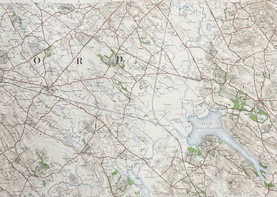
ORDNANCE SURVEY OF IRELAND/ Sheet No.99/ KILDARE, MEATH, KINGS & WESTMEATH/ Published in 1902Churchill Galleries3.7(217)See Sold PriceFeb 26, 2024
ORDNANCE SURVEY OF IRELAND/ Sheet No.100/ KILDARE, MEATH & WESTMEATH/ Published in 1903Churchill Galleries3.7(217)See Sold PriceFeb 26, 2024
ORDNANCE SURVEY OF IRELAND/ Sheet No.100/ KILDARE, MEATH & WESTMEATH/ Published in 1903Churchill Galleries3.7(217)See Sold PriceFeb 26, 2024
ORDNANCE SURVEY OF IRELAND/ Sheet No.100/ KILDARE, MEATH & WESTMEATH/ Published in 1903Churchill Galleries3.7(217)See Sold PriceFeb 26, 2024
ORDNANCE SURVEY OF IRELAND/ Sheet No.100/ KILDARE, MEATH & WESTMEATH/ Published in 1903Churchill Galleries3.7(217)See Sold PriceFeb 26, 2024
ORDNANCE SURVEY OF IRELAND/ Sheet No.100/ KILDARE, MEATH & WESTMEATH/ Published in 1903Churchill Galleries3.7(217)See Sold PriceFeb 26, 2024
ORDNANCE SURVEY OF IRELAND/ SHEET NO.109/ KING CO. & CO. WESTMEATH. / PUBLISHED IN 1900Churchill Galleries3.7(217)See Sold PriceFeb 26, 2024