ATLAS of ANTIENT GEOGRAPHY by SAMUEL BUTLER 1843John McInnis Auctioneers,LLC4.6(502)See Sold PriceFeb 24, 2024
18TH C. ANTIQUE MAP: FRENCH & INDIAN WAR, FRAMEDThomaston Place Auction Galleries4.4(386)See Sold PriceFeb 24, 2024
Rand McNally Railroad Map Cabinet w/ 21 Railroad MapsRail & Road Auctions4.6(165)See Sold PriceMar 08, 2024
Keith Haring - Ink on New York Map, Best Buddies, Inscribed, Signed, and DatedSapphire Auction Gallery4(67)See Sold PriceMar 02, 2024
LATE 17TH C. FRENCH MAP OF THE NEW WORLD BY ALEXIS-HUBERT JAILLOT (1632-1712)Thomaston Place Auction Galleries4.4(386)See Sold PriceFeb 24, 2024
Central Railroad of New Jersey Map of Sandy Hook Route-ca. 1903JM Hobby Supply and Railroad Artifact Auctions4.4(126)See Sold PriceFeb 24, 2024
Lot of Six Mixed Atlas Box Cars-HO Scale-New in BoxJM Hobby Supply and Railroad Artifact Auctions4.4(126)See Sold PriceFeb 25, 2024
Rand McNally/Santa Fe Railroad Map of Iowa-1912JM Hobby Supply and Railroad Artifact Auctions4.4(126)See Sold PriceFeb 24, 2024
NICOLAES VISSCHER (NETHERLANDS, 1618-1709) MAP OF THE NEW WORLDThomaston Place Auction Galleries4.4(386)See Sold PriceFeb 24, 2024
17TH C. WORLD MAP BY NICOLAES VISSCHER (NETHERLANDS, 1618-1709)Thomaston Place Auction Galleries4.4(386)See Sold PriceFeb 24, 2024
Lot of Six Mixed Atlas Cabooses-HO Scale-New in BoxJM Hobby Supply and Railroad Artifact Auctions4.4(126)See Sold PriceFeb 25, 2024
SoldFRAMED HAND-COLORED MAP "Vectis Insula, Anglice: TheFRAMED HAND-COLORED MAP "Vectis Insula, Anglice: The Isle of Wight", showing coats of arms in upper right, c. 1648, published in Amsterdam, framed by "Goodspeed's Book Shop, Boston" label on reverse",See Sold Price
Blaeu map of Isle of WightTitle: Vectis Insula. Anglice the Isle of Wight Author: Blaeu, Willem & Joan Description: Copper-engraved map, hand-colored in outline & wash, colored pictorial cartouche, armorial shields and sailingSee Sold Price
SoldMap, Jan Jansson, Isles of Wight, Guernsey, ManFramed 18th century handcolored engraved map, Mona Insula Vulgo: Anglesey (Guernsey), The Isle of Man, and Anglice The Isle of Wight, by or after Jan Jansson (Dutch, 1588-1664), text verso with titlesSee Sold Price
Britannia Map, Robert de Vaugondy, 1750Framed hand-colored map of Britannia, by Nicolao Sanson and Robert de Vaugondy, dated 1750. Latin: Britannicae, Insula. Measures 20.75" x 22.5". Framed and matted measurement 30.25" x 31.5".See Sold Price
SoldCaptus Incanno 1564 Map - Georg HovennagitusFramed hand-colored map "Captus Incanno 1564," marked Gades AB Occiduis Insulae Partibus. Dimensions: 14.5" H x 22" W; See Sold Price
SoldJohannes Blaeu, VECTIS INSULA ANGLICE, map of Islev ofJohannes Blaeu, VECTIS INSULA ANGLICE, map of Islev of Wight with hand coloured engraving, back with double printed Latin text pages from Brittania, 38.5 x 50cmSee Sold Price
SoldGeorg Matthaus Seutter, Framed Map of CreteFramed map of Crete by map maker Georg Matthaus Seutter. Titled: Insula Creta nunc Candia, Date : Augsburg, 1741. Hand-colored map divided into its four territories, and the islands to its north. TheSee Sold Price
SoldTwo framed maps including Abraham Ortelius CypriTwo framed maps including Abraham Ortelius Cypri Insulae Nova Descript 1573 hand colored engraved map and La Judee ou Palestine, George du Rey Paris map. sight size 11 1/4" x 13" and 14" x 19 1/2"See Sold Price
SoldAbraham Ortelius, Acores Insulae map(Dutch, 1527-1598). Hand-colored copper engraved map, 17th century or later, 15 x 22 in., framedSee Sold Price
SoldWillem Blaeu, MapBlaeu, Willem , "Insulae Americanae in Oceano Septentrionali, cum Terris Adiacentibus", Amsterdam, 1635, hand-colored engraved map, 14 3/4 in. x 20 1/4 in., framedSee Sold Price
SoldWillem Blaeu "India Quae Orientalis Dictitor et InsulaeWillem Blaeu"India Quae Orientalis Dictitor et Insulae Adiocentes, Amsterdam, 1635, centered on Island of Java and Southeast Asia", map sight size: 17" x 20 1/4"hand-colored engravings, two framed mapSee Sold Price
SoldFRAMED HAND COLORED MAP 1817, US & ST. LAURENCE RVFramed hand colored map, "The United States of America (with) The course of the River St. Laurence, from Lake Ontario to Manicouagan Point" engraved by J.G. Menzies, from "A new general atlas, consistSee Sold Price
SoldNEW ZEALAND 1851 FRAMED HAND COLORED MAPEngraved map of New Zealand 1851. J Rapkin, the illustrations by H. Warren & engraved by J. B. Allen . Hand colored with decorative border, inset vignette views.. Image 10 x 26 inches. Overall 14 1/2See Sold Price
SoldFramed Hand Colored Map of The World 19th CenturyFramed Hand Colored Map of The World 19th Century. Original Map of World Hemispheres with supposed population and religious division. Certificate of Authenticity on back.Condition: Very Good, slight wSee Sold Price
SoldTwo Early Framed Hand Colored Mapscomprising Johann Baptist Homann (German, 1664-1724), "Nova Anglia" and a smaller unsigned map, "Dania Regnum." Not examined out of frames. Stains, toning. Largest: 27 1/2" high, 30 1/2" wide. ProvenaSee Sold Price
SoldAntique Framed & Hand Colored Map of LiverpoolAntique Framed & Hand Colored Map of Liverpool England. Measures 20 x 24 inches.See Sold Price
SoldFramed Hand Colored Map of Wilshire, EnglandFramed Hand Colored Map of Wilshire, England. 29 inches x 32 inchesSee Sold Price
SoldFramed Hand Colored Map - " Descrittione DellisoleFramed Hand Colored Map - " Descrittione Dellisole MOLVCCHE - Plate # 189 - image size 9 1/4" x 6"See Sold Price
Framed Hand Colored Map, Porto de TriesteFramed Hand Colored Map, Porto de Trieste {Dimensions of frame 25 1/4 x 27 1/4 inches} [crack to glass of frame]See Sold Price
SoldFramed Hand Colored Map of the City of Charleston,Framed Hand Colored Map of the City of Charleston, S.C. by Colton, dated 1855. 11"h. X 7"w. sight and 18 3/4"h. X 14 3/4"w. o/a Condition: GoodSee Sold Price
SoldFramed hand colored map of New York State - CopyrightFramed hand colored map of New York State - Copyright 1876 by O. W. Gray & Son. Crease down the center, minor foxing on bottom but otherwise good condition. 15.5" x 24".See Sold Price
NEW ZEALAND 1851 FRAMED HAND COLORED MAPAntique engraved map of New Zealand 1851. J Rapkin, the illustrations by H. Warren & engraved by J. B. Allen . Hand colored with decorative border, inset vignette views.. Image 10 x 26 inches. OverallSee Sold Price
Sold43"x34" framed hand colored map of Nantucket43"x34" framed hand colored map of NantucketSee Sold Price
SoldHAND COLORED MAP. *INSULA S. JUAN DE PERTO RICO, CAIBESHAND COLORED MAP. *INSULA S. JUAN DE PERTO RICO, CAIBES VEL CANIBALUM INSULAE* BY JANSON. 20 3/8 X 16 INCH IMAGE. HAS UNEVEN TONING. VERTICAL CREASE IN THE CENTER. HAS PROFESSIONAL REPAIRS AND HAS BEESee Sold Price
EARLY 18TH C. DUTCH CHART OF PACIFIC OCEAN BY FREDERIK DE WIT (1629-1706) WITH CALIFORNIA AS ANThomaston Place Auction Galleries4.4(386)See Sold PriceFeb 24, 2024
17TH C. ANTIQUE MAP SIEGE OF LA ROCHELLE, FRANCE, FRAMEDThomaston Place Auction Galleries4.4(386)See Sold PriceFeb 24, 2024
EARLY 18TH C. MAP OF ITALY, FRAMEDThomaston Place Auction Galleries4.4(386)See Sold PriceFeb 24, 2024
18TH C. ANTIQUE MAP: FRENCH & INDIAN WAR, FRAMEDThomaston Place Auction Galleries4.4(386)See Sold PriceFeb 24, 2024
17TH C. ENGLISH LINEAR MAP BY OGILBY, FRAMEDThomaston Place Auction Galleries4.4(386)See Sold PriceFeb 24, 2024
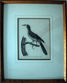
Le Valliant Crowned Hornbill Calao Couronne Rare Engraving ca1802 Framed OrnithologyLuis Porretta Fine Arts4.3(10)See Sold PriceMar 02, 2024
Max Papart (1911-1994) Lithograph Hand Signed 11" x 11" Blue & Green FormsLuis Porretta Fine Arts4.3(10)See Sold PriceMar 02, 2024
WILLIAM HEATH Rare Political Cartoon Siamese Youths c1829 LithographLuis Porretta Fine Arts4.3(10)See Sold PriceMar 02, 2024
TOTI LEWIS Canadian Listed Artist Mural Painters Artists Proof Etching 1983Luis Porretta Fine Arts4.3(10)See Sold PriceMar 02, 2024
PIETER SCHENK / VALK / JANSSEN Hand Colored Map of Rhodes Greece ca1702 vgcLuis Porretta Fine Arts4.3(10)See Sold PriceMar 02, 2024
THOMAS MOULE 1837 Colored Map of Warwickshire Framed vgcLuis Porretta Fine Arts4.3(10)See Sold PriceMar 02, 2024
Hand Colored Map of the city of Amsterdam 1720Global Auctions Company4.3(36)See Sold PriceMar 03, 2024
17th Century Hand Colored Engraved Map of GermanyGlobal Auctions Company4.3(36)See Sold PriceMar 03, 2024
18th Century Hess Germany Hand colored Engraved MapGlobal Auctions Company4.3(36)See Sold PriceMar 03, 2024
[ARCTIC]. BOWEN, Emanuel. A New & Accurate Map of the North...Potter & Potter Auctions4.6(539)See Sold PriceMar 07, 2024
Johann Homann Hand-Colored Map Engraving, c. 1730Auctions at Showplace4.5(726)See Sold PriceMar 17, 2024
Framed Hand Colored Antique Map of the Department of Nord, FranceDonny Malone Auctions4.5(1.7k)See Sold PriceMar 04, 2024
4 FRAMED HAND COLORED 19THC. ITALIAN ENGRAVINGS IN 2 FRAMES. ROME, FLORENCE, CAPO DI MONTE (28 1/4"Carlsen Gallery, Inc.4.6(163)See Sold PriceMar 03, 2024
Galliae Regionis Nova Descriptio Hand Colored Map of France on Laid Paper, Ca. 16th Century, H 10" WDuMouchelles4.6(825)See Sold PriceMar 15, 2024


![[ARCTIC]. BOWEN, Emanuel. A New & Accurate Map of the North... (1 of 1)](https://p1.liveauctioneers.com/928/318880/171360917_1_x.jpg?height=282&quality=70&version=1707501302)


