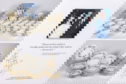
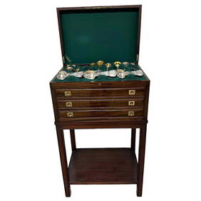
THE FITZGERALD FAMILY TEA and DINNER SERVICEJohn McInnis Auctioneers,LLC4.5(505)See Sold PriceFeb 25, 2024
A CHINESE PORCELAIN GREEN ENAMELED DRAGON MOON FLASK BIANHUBerkeley Auction Gallery4.4(16)See Sold PriceMar 03, 2024
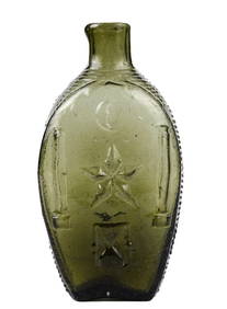
RARE COVENTRY GLASS WORKS MASONIC FLASKJohn McInnis Auctioneers,LLC4.5(505)See Sold PriceFeb 25, 2024
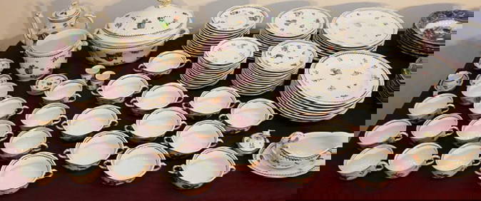
100 Pieces Of Ginori Italian Fruit 1735 ChinaRalph Fontaine Heritage Auctions Inc.4.7(236)See Sold PriceFeb 25, 2024
A Fine 19th C. English 183pc Dinnerware Set by CAULDONPremier Auction Galleries4.4(331)See Sold PriceMar 09, 2024
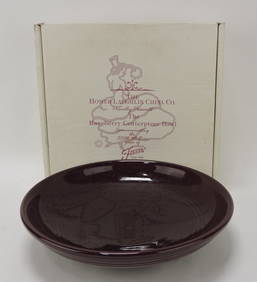
HEREND PORCELAIN "FRUITS & FLOWER" DISH SETThomaston Place Auction Galleries4.4(393)See Sold PriceFeb 25, 2024
Andy Warhol (1928-1987) Space Fruit Cantaloupes IHill Auction Gallery 4.7(1k)See Sold PriceFeb 28, 2024
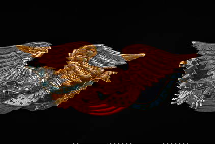
ARTISTIC CARVING CO "CHESAPEAKE" AMERICAN EAGLEJohn McInnis Auctioneers,LLC4.5(505)See Sold PriceFeb 25, 2024
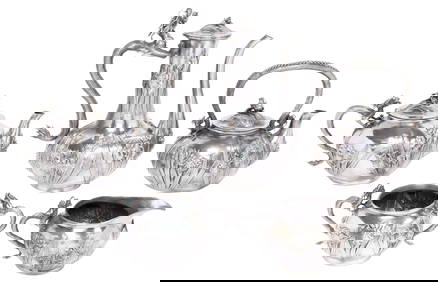
(5) FINE JAPANESE KONOIKE SILVER DRAGON & IRISES TEA & COFFEE SERVICEAustin Auction Gallery4.7(1.2k)See Sold PriceFeb 25, 2024
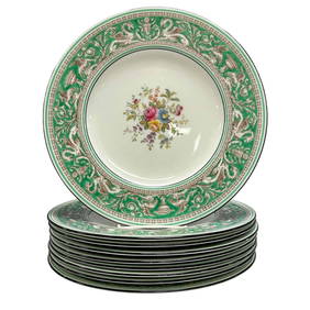
WEDGWOOD Florentine Green Border Dinner PlatesPremier Auction Galleries4.4(331)See Sold PriceMar 09, 2024
Immense 229pc GORHAM Floretine Sterling FlatwarePremier Auction Galleries4.4(331)See Sold PriceMar 09, 2024
Tiffany & Co Sterling Silver Crystal Ewer Pitcher Figural Pair AntiqueHess Fine Auctions4.5(210)See Sold PriceMar 02, 2024
Colton Map of WetCOLTON, Joseph Hutchins (1800-1893). Map of the United States, the British Provinces, Mexico & c. Showing the Routes of the U.S. Mail Steam Packets to California and a Plan of the Gold Region. New YorSee Sold Price
SoldColton: Map of North America, 1855Map: North America Cartographer: J.H. Colton Illustrator: J.H. Colton Publisher: J.H. Colton Co. Published: New York, 1855 Size: 12.75 x 15.75 inches Extremely nice example with very nice full hand-coSee Sold Price
Colton: Map of Texas, 1855Map: Texas Cartographer: J. H. Colton Illustrator: J. H. Colton Edition: First Edition Publisher: J. H. Colton, Co. Published: New York, 1855 Size: 12.75 x 15.5 inches Counties current to 1854 makingSee Sold Price
Sold1856 COLTON MAP CHARLESTON SCMap is from Colton's Atlas Of The World published by J.H. Colton And Company, 1856. Map was of Charleston, South Carolina and Savannah, Georgia. Framed with only Charleston showing. Professionally fraSee Sold Price
SoldColton MAP OF THE STATE OF MISSISSIPPI 1867 EngravedDetails: COLTON, George W. (1827-1901) & Charles B. (1832-1916). Colton's Map of the State of Mississippi. New York: G.W. & C.B. Colton & Co., 1867. Engraved folding pocket map, full contemporary hanSee Sold Price
Colton: Map of Nebraska & Kanzas, 1855Map: Nebraska and Kanzas Cartographer: J. H. Colton Illustrator: J. H. Colton Publisher: J. H. Colton, Co. Published: New York, 1855 Size: 12.5 x 15.75 inches Extremely nice example with full hand-colSee Sold Price
Sold1856 Colton Map Of New Orleans And Louisville1856 Colton Map Of New Orleans And Louisville -- The City Of Louisville Kentucky [on Sheet With] The City Of New Orleans Louisiana J Colton, 1856, New York, 15 x 13 in. This is a very nice map of twoSee Sold Price
SoldColton: Map of Washington & Oregon, 1855Map: Washington and Oregon Cartographer: Colton, J. H. Illustrator: Colton, J. H., Publisher: Colton, J. H. Co., Published: New York, 1855 Size: 12.75 x 15.75 Description: Extremely nice example withSee Sold Price
Colton: Map of The German Confederation, 1856Map: The German Confederation. Maker: J.h. Colton & Co., Colton, Joseph Hutchins Publication Date: 1856 Publisher: J.h. Colton & Co. Size: Quarto – 12.75 H x 15.60 W Inches Germany No.1, 2, and 3. TSee Sold Price
SoldJ. H. Colton: Map of United States of America, 1855The United States of America. J. H. Colton, 1855. 15.75 x 26. From the 1856 second edition of Colton’s Atlas of the World. Clean with very minor edge toning. Couple of tiny margin spots. One extremeSee Sold Price
Sold1855 Colton Map of Arabian Peninsula, Iraq and Iran --Title/Content of Map: 1855 Colton Map of Arabian Peninsula, Iraq and Iran -- Persia, Arabia &c. Date: 1855, New York Cartographer: J Colton Size: 12 X 14.7 in. A very nice map of the Arabian peninsulaSee Sold Price
SoldJ.H. Colton, "Map of the United States, the BritishJ.H. Colton, "Map of the United States, the British Provinces and Mexico, Showing the Routes of the U.S. Mail Steam Packets to California, and a Plan of the Gold Region" (New York, Colton 1849); ThisSee Sold Price
Sold1855 Colton Map of Hawaii, New Zealand, Oceania IslandsTitle/Content of Map: 1855 Colton Map of Hawaii, New Zealand, Oceania Islands -- Hawaii or Sandwitch Islands [with] Samoan.. [with] New Zealand [with] Viti Group or Feejee Islands [with] Societi IslanSee Sold Price
Sold1856 Colton Map of AsiaJ. Colton 1856 New York 12.5 x 15.5 in. This nice map of Asia extends from Turkey to Alaska and south into parts of Indonesia, with potions of Indonesia omitted. Fine coloring. Please note that this lSee Sold Price
SoldColton Map of China, 1865Title: 1865 Colton Map of China Cartographer: J. Colton Published: 1865 c. New York Measurements: 13.3 x 16 in. China. This excellent map of China with insets of Amoy and Canton of the lower part of BSee Sold Price
Sold1855 Colton Map of Philadelphia -- PhiladelphiaReserve Reduced! Title/Content of Map: 1855 Colton Map of Philadelphia -- Philadelphia Date: 1855, New York Cartographer: J Colton Size: 15.3 X 13.5 in. This is a very attractive city map. It is fullSee Sold Price
SoldColton: Map of Hindostan Or British India, 1857Title: Map of Hindostan Or British India by Colton Date: 1857 Dimensions: 14 x 17 Medium: Hand Colored Lithograph Please note that this lot has a confidential reserve. When you leave a bid in advanceSee Sold Price
SoldColton: Map of California Nevada Utah Colorado ArizonaColton's Map of California, Nevada, Utah, Colorado, Arizona & New Mexico, 1865/1869. Early edition of Colton's map of the Southwestern United States. Unlike in the prior edition, Nevada is no longer tSee Sold Price
Sold1855 Colton Map of China -- ChinaTitle/Content of Map: 1855 Colton Map of China -- China Date: 1855, New York Cartographer: J Colton Size: 12.3 X 14.4 in. This is a very nice map of China extending well into today's Russia, and yet tSee Sold Price
SoldImpressive 1854/56 Colton map of LouisianaBeautiful map of Louisiana with 1854 date. From Colton’s 1856 Atlas of the World, one of the best American atlases of the mid-19th century. Detailed map with decorative border, colored by parish andSee Sold Price
Sold1855 Colton Map of East Indies -- East IndiesTitle/Content of Map: 1855 Colton Map of East Indies -- East Indies Date: 1855, New York Cartographer: J Colton Size: 11.6 X 14.5 in. This is a rather handsome map of Southeast Asia covering IndochinaSee Sold Price
Sold1855 Colton Map of Florida -- FloridaReserve Reduced! Title/Content of Map: 1855 Colton Map of Florida -- Florida Date: 1855, New York Cartographer: J Colton Size: 11.8 X 14.5 in. This is an outstanding Florida map. It features only thirSee Sold Price
SoldColton MAP OF THE UNITED STATES THE CANADAS &C 1853Details: COLTON, J.H. (1800-1893). Colton's Map of the United States the Canadas &c. Showing the Rail Roads, Canals & Stage Roads with Distances from Place to Place. New York: Colton, 1853. Folding pSee Sold Price
SoldJ. H. Colton: Map of Mexico & Texas, 1854.Mexico (includes part of Texas). J. H. Colton, 1854. 12.75 x 16. From the 1856 second edition of Colton’s Atlas of the World. Nice color and good impression. Clean. Hint of edge toning at sides. TwoSee Sold Price
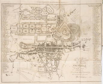
18TH C. ANTIQUE MAP: FRENCH & INDIAN WAR, FRAMEDThomaston Place Auction Galleries4.4(393)See Sold PriceFeb 24, 2024
19thc Colton Map, Comparitive Size of Lakes & IslandsConnoisseur Auctions3.9(336)See Sold PriceFeb 24, 2024
1853 Colton's Railroad & Township Map of Massachusetts, Rhode Island, and ConnecticutRail & Road Auctions4.6(165)See Sold PriceMar 07, 2024
Pair of Early Railroad Maps - 1862 Pittsburgh, Ft. Wayne & Chicago Railway and 1873 PennsylvaniaRail & Road Auctions4.6(165)See Sold PriceMar 07, 2024
Keith Haring - Ink on New York Map, Best Buddies, Inscribed, Signed, and DatedSapphire Auction Gallery4(67)See Sold PriceMar 02, 2024
Rand McNally Railroad Map Cabinet w/ 21 Railroad MapsRail & Road Auctions4.6(165)See Sold PriceMar 08, 2024
Putnam - First Map of the State of Ohio by Rufus PutnamTrillium Antique Prints & Rare Books4.5(32)See Sold PriceFeb 24, 2024
Scotland.- Sir Walter Scott's Edinburgh.- The Post-Office annual directory, from Whitsunday 1808, toForum Auctions4.3(53)See Sold PriceFeb 29, 2024
Map of Part of the West Indies, Etc., Showing the Exact Position Of The U.S. War Steamer SanJasper524.5(9.9k)See Sold PriceFeb 27, 2024
West Africa. Liberia Sahara Senegambia Guinea. Mountains of Kong COLTON 1869 mapJasper524.5(9.9k)See Sold PriceFeb 28, 2024
North west Africa. Liberia inset. Sahara Senegambia Guinea. COLTON 1863 mapJasper524.5(9.9k)See Sold PriceFeb 28, 2024
ANTIQUE GEOMORPHOLOGY: 1782 POMPONII MELA DE SITU ORBIS ARMORIAL VELLUM BINDINGNY Elizabeth 4.2(86)See Sold PriceMar 03, 2024
Rare 19thc Colton Map, Argentine Republic, Chile, Uruguay, PataguayConnoisseur Auctions3.9(336)See Sold PriceMar 16, 2024
Reprint From The Original Coltons Map 1855 No.30 Copyright 1967Rapid Estate Liquidators and Auction Gallery4.5(1.1k)See Sold PriceFeb 29, 2024