ATLAS of ANTIENT GEOGRAPHY by SAMUEL BUTLER 1843John McInnis Auctioneers,LLC4.6(502)See Sold PriceFeb 24, 2024
18TH C. ANTIQUE MAP: FRENCH & INDIAN WAR, FRAMEDThomaston Place Auction Galleries4.4(386)See Sold PriceFeb 24, 2024
Rand McNally Railroad Map Cabinet w/ 21 Railroad MapsRail & Road Auctions4.6(165)See Sold PriceMar 08, 2024
Keith Haring - Ink on New York Map, Best Buddies, Inscribed, Signed, and DatedSapphire Auction Gallery4(67)See Sold PriceMar 02, 2024
LATE 17TH C. FRENCH MAP OF THE NEW WORLD BY ALEXIS-HUBERT JAILLOT (1632-1712)Thomaston Place Auction Galleries4.4(386)See Sold PriceFeb 24, 2024
Central Railroad of New Jersey Map of Sandy Hook Route-ca. 1903JM Hobby Supply and Railroad Artifact Auctions4.4(126)See Sold PriceFeb 24, 2024
Lot of Six Mixed Atlas Box Cars-HO Scale-New in BoxJM Hobby Supply and Railroad Artifact Auctions4.4(126)See Sold PriceFeb 25, 2024
Rand McNally/Santa Fe Railroad Map of Iowa-1912JM Hobby Supply and Railroad Artifact Auctions4.4(126)See Sold PriceFeb 24, 2024
NICOLAES VISSCHER (NETHERLANDS, 1618-1709) MAP OF THE NEW WORLDThomaston Place Auction Galleries4.4(386)See Sold PriceFeb 24, 2024
17TH C. WORLD MAP BY NICOLAES VISSCHER (NETHERLANDS, 1618-1709)Thomaston Place Auction Galleries4.4(386)See Sold PriceFeb 24, 2024
Lot of Six Mixed Atlas Cabooses-HO Scale-New in BoxJM Hobby Supply and Railroad Artifact Auctions4.4(126)See Sold PriceFeb 25, 2024
SoldFRAMED MAP OF THE STATE OF VIRGINIA, 1861"Lloyd's Official Map of the State of Virginia from actual surveys by order of the Executive 1828 & 1859"; some losses at fold lines; small insect damage below "v" in Virginia; dark stain at lower botSee Sold Price
SoldMAP OF THE UNITED STATES, C. 1861Framed map of the United States, 1861, showing 32 named states with western areas mostly in irregular shapes, penciled date of 1861, sight: 3.5/8"h, 5.75"w, overall: 10"h, 12'w, 1.5lbs Start Price: $8See Sold Price
Sold4 Maps incl. Division of US Army in Virginia4 Maps Atlas to Accompany the Official Records of Union + Confederate Army's 1861-1865, US Army in Virginia Map Framed with Tear -See Sold Price
Sold2) BONNE MAP FLORIDA, LOUISIANA, GEORGIA, VIRGINIA(lot of 2) Framed maps, including: (1) "Carte de la Louisiane et da la Floride," Rigobert Bonne (French, 1727-1794), showing the southeastern United States, extending from Virginia and Southern IllinoSee Sold Price
SoldLloyd's Official Map of the State of VirginiaLloyd’s Official Map of the State of Virginia. J.T. Lloyd (fl. mid-19th century). Engraving with original hand color in full . New York: J.T. Lloyd, 1861. 31 1/2 x 51 inches sheet, 36 1/2 x 56 incheSee Sold Price
SoldJ. T. Lloyd. Lloyd's Official Map of the State oJ. T. Lloyd. Lloyd's Official Map of the State of Virginia.<See Sold Price
Sold1845 VIRGINIA MAP1845 VIRGINIA MAP, hand-colored engraving on paper, titled "The Tourist's Pocket Map of the State of Virginia," by J. H. Young, published by S. Augustus Mitchell, 1845. Framed and matted. Mid 19th cenSee Sold Price
MAP, Virginia & West Virginia, LloydVirginia & West Virginia, Civil War. James T. Lloyd, Lloyd's Official Map of the State of Virginia from Original Surveys by Order of the Executive 1828 & 1859..., 1861 (dated). Hand Color. This scarceSee Sold Price
The best geographical information on Virginia at theLLOYD, J. T. (fl. mid-19th century). Lloyd's Official Map of the State of Virginia. Engraved map with original hand color in full . New York: J.T. Lloyd, 1861. 31 1/2 x 51 inches sheet, 36 1/2 x 56 inSee Sold Price
Mitchell: County Map of Virginia and West VirginiaThe beautifully detailed and colored county map of the states of Virginia and West Virginia from the 1870 edition of Mitchell's popular New General Atlas of the world. The map is framed by the vine moSee Sold Price
SoldAntique Map, Ca. 1895 -Atlas to Union & Conf ArmyVintage Framed Map. Harper's Ferry Cedar Creek Virginia Savannah Georgia c1895 antique Civil War map. Atlas to Accompany the Official Records of the Union and Confederate Armies in 1861-1865. ... UppeSee Sold Price
Antique Map, Ca. 1895 -Atlas to Union & Conf ArmyVintage Framed Map. Harper's Ferry Cedar Creek Virginia Savannah Georgia c1895 antique Civil War map. Atlas to Accompany the Official Records of the Union and Confederate Armies in 1861-1865. ... UppeSee Sold Price
Vintage Civil War Era MapVintage Framed Map. Harper's Ferry Cedar Creek Virginia Savannah Georgia c1895 antique Civil War map. Atlas to Accompany the Official Records of the Union and Confederate Armies in 1861-1865. ... UppeSee Sold Price
Vintage Civil War Era MapVintage Framed Map. Harper's Ferry Cedar Creek Virginia Savannah Georgia c1895 antique Civil War map. Atlas to Accompany the Official Records of the Union and Confederate Armies in 1861-1865. ... UppeSee Sold Price
Vintage MapVintage Framed Map. Harper's Ferry Cedar Creek Virginia Savannah Georgia c1895 antique Civil War map. Atlas to Accompany the Official Records of the Union and Confederate Armies 1861-1865 ... Upper PoSee Sold Price
SoldColton’s Map Of The Southern States. 1861.[Southeast]. Colton’s Map Of The Southern States. Including Maryland, Delaware, Virginia, Kentucky, Tennessee. Missouri. North Carolina, South Carolina, Georgia, Alabama, Mississippi, Arkansas, LouiSee Sold Price
SoldLarge map of Confederacy 1861Title: Colton's Map of the Southern States. Including Maryland, Delaware, Virginia, Kentucky, Tennessee, Missouri, North Carolina, South Carolina, Georgia, Alabama, Mississippi, Arkansas, Louisiana anSee Sold Price
SoldFRAMED MAINE SCHOOL MAP1862 Map of the State of Maine by H.F. Walling, published by J. Chace, Jr. in Portland, having cartouches of town plans with landowners' names and mountains; plus 1861 Map of the United States by theSee Sold Price
Sold(2) 1860 MAP, MOSTLY TEXAS & SOUTHERN STATES MAP(2) Framed Map: Louisiana, Mississippi, Arkansas and Part of Texas, from Smith's New Geography, J.B. Lippincott & Co., 1861, Philadelphia (Roswell C. Smith, 1797-1875), hand colored, sight: 11.75"h, 1See Sold Price
SoldTwo matted framed print maps: 1) The Norfolk andTwo matted framed print maps: 1) The Norfolk and Western Railway, The Cavalier and The Pocahontas, route of railway marked from Columbus to Virginia Beach, 6x8, 2) a map of Nea-Polynesia or The IslandSee Sold Price
Sold1879 MAP, WARREN'S NEW ENGLAND OR EASTERN STATESFramed hand colored map, "Map of New England or Eastern States", page 33, "Common School Geography", David M. Warren (1820-1861), Cowperthwait & Co., Philadelphia, 1879, showing Maine, New Hampshire,See Sold Price
SoldCivil War Era Lithographed Map of the United StatesLloyd’s Military Maps. H. H. Lloyd and Company. Hand-colored lithograph. New York, 1861. 27” x 36” inches sheet, 45 x 37 1/2 inches framed. Lloyd’s Military Maps, published by H.H. Lloyd and CSee Sold Price
Sold18th Century Map of Southeastern United StatesRigobert Bonne, Paris, circa 1780. engraving on paper of Southeast including Virginia, North and South Carolina, and Georgia. framed. 8 3/4" x13" (plate)See Sold Price
SoldAntique Map of Central East United StatesFramed and matted Antique Map of Delaware, Illinois, Indiana, Iowa, Kentucky, Maryland, Missouri, New Jersey, North Carolina, Ohio, Pennsylvania, Tennessee, and West Virginia. Map is in very good condSee Sold Price
Vintage Estate World Maps II Signed & Framed Art PrintMannys Jewelry4.6(331)See Sold PriceMar 03, 2024
Vintage County Map Of NY State Plate EngravingThe Benefit Shop Foundation Inc.4.3(2.9k)See Sold PriceFeb 28, 2024
Pair of Early Railroad Maps - 1862 Pittsburgh, Ft. Wayne & Chicago Railway and 1873 PennsylvaniaRail & Road Auctions4.6(165)See Sold PriceMar 07, 2024
1867 Map of the Railroads of The State of New YorkRail & Road Auctions4.6(165)See Sold PriceMar 08, 2024
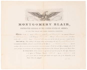
SOMERSET, Lord Charles (1767-1831) and BLAIR, Montgomery (1...Potter & Potter Auctions4.6(539)See Sold PriceMar 07, 2024
2009 Chic-Fil-A Bowl Full Ticket 12/31 Virginia Tech v Tennessee 85073Mynt Auctions4.6(680)See Sold PriceFeb 28, 2024
WALLACE NUTTING (1861-1941) HAND SIGNED LIMITED EDITION PLATINOTYPE TITLED AFFENTIONATELY YOURS –The Rug Life4.3(12)See Sold PriceMar 07, 2024
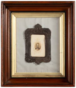
JOHN J. AUDUBON (1785-1851) LITHOGRAPH TITLED RED SHOULDERED HAWK, 19IN x 25IN (48cm x 64cm)The Rug Life4.3(12)See Sold PriceMar 07, 2024
Abraham Lincoln Facsimile REPRODUCTION Signed Check Display Custom Framed PhotoBidhaus4.3(747)See Sold PriceFeb 26, 2024
Abraham Lincoln Facsimile REPRODUCTION Signed Check Display Custom Framed PhotoMynt Auctions4.6(680)See Sold PriceMar 01, 2024
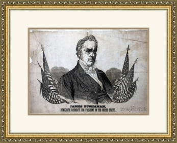
James Buchanan 1856 Campaign Poster Custom Gallery Framed ReproductionMynt Auctions4.6(680)See Sold PriceMar 01, 2024
1960 Basketball Yearbook Magazine Jerry West West Virginia 73962Mynt Auctions4.6(680)See Sold PriceMar 01, 2024
Vintage 1940s West Virginia State Pennant 30x12" HBCU Very Rare 91784Mynt Auctions4.6(680)See Sold PriceMar 02, 2024
Map of Yorktown - York County in Virginia - United StatesProverde Auctions4.3(3)See Sold PriceFeb 28, 2024
Map of United States of North America, 1785Antiques Online Auctions4.6(407)See Sold PriceMar 14, 2024
Vintage 1920s Rand McNally Auto Trails MapThe Benefit Shop Foundation Inc.4.3(2.9k)See Sold PriceMar 20, 2024