Sold1845 VIRGINIA MAP1845 VIRGINIA MAP, hand-colored engraving on paper, titled "The Tourist's Pocket Map of the State of Virginia," by J. H. Young, published by S. Augustus Mitchell, 1845. Framed and matted. Mid 19th cenSee Sold Price
Sold1845 Historical Collections of Virginia with Map 1st Ed1845 Historical Collections of Virginia with Map 1st Ed First Edition of Henry Howe's Book Historical Collection of Virginia, containing A Collection of the most interesting facts, traditions, biogrSee Sold Price
5 vols. Various State Historical Collections.[Americana] 5 volumes. (1) 2 Copies. Howe, Henry. Historical Collections of Virginia. Babcock & Co., Charleston, S.C., 1845. (2) Barber, John W. Historical Collections of the State of New-York. Clark,See Sold Price
SoldChart of Outer Banks, 1853 U. S. Coast SurveyReserve Reduced! Hand-colored chart of the Outer Banks on the east coast of North Carolina and Virginia. “Sketch D Showing the Progress of Section IV, 1845-1853.” Area shown includes Albemarle SouSee Sold Price
SoldChart of Outer Banks, 1853 U. S. Coast SurveyHand-colored chart of the Outer Banks on the east coast of North Carolina and Virginia. “Sketch D Showing the Progress of Section IV, 1845-1853.” Area shown includes Albemarle Sound, Pamlico SoundSee Sold Price
SoldFry & Jefferson. Maryland and Virginia mapdated 1755; "Carte de la Virginie et de Maryland," (sic) by Robert de Vaugondy based on a map by Joshua Fry and Peter Jefferson, 21 x 26 in., in ebonized giltwood eglomise frameSee Sold Price
SoldDated 1845 MapDated 1845 roll out map "The Empire State New York.....Published by Augustus Mitchell....Philadelphia". 50" x 40".See Sold Price
1845 Map of Cotes de BarbarieItem: 1845 Map of Cotes de Barbarie Description: “Cotes De Barbarie”, printed at Paris, Monin and Fremin, published by Binet, c 1845. Fine hand colored outlines, 12 x 9.5”. Please note that thisSee Sold Price
Sold1822 VIRGINIA MAP1822 VIRGINIA MAP, hand-colored engraving, "Geographical, Statistical and Historical Map of Virginia" by Henry Charles Carey and Isaac Lea, Philadelphia, with descriptive text along lower edge. ModernSee Sold Price
SoldNORFOLK VIRGINIA MAP ON SILKVintage framed map on silk of PANORAMA OF NORFOLK VA AND SURROUNDINGS after the original in 1892 - Compliments of FL Grandy Hay and Seed Dealer. Overall size framed 27 x 43 inches.See Sold Price
SoldVIRGINIA. Map. NY: J.H. Colton & Co., (cprt 1855)[United States/Virginia]. VIRGINIA. NY: J.H. Colton & Co., (cprt 1855). Inner border: 10 7/8” x 13 ¾”. Map in prtd color, insets of Richmond nad Norfolk area uncolored. Sight condition very good.See Sold Price
SoldVirginia Map.- , 906 acres... Mecklinbugg*** Please note the description of this lot has changed *** Virginia map.- Dedman (Samuel, surveyor) 906 acres... Mecklinbugg County... Survey'd for Roger Atkinson..., D.s. "Saml Dedman", small manuscSee Sold Price
SoldBRADLEY & COMPANY "COUNTY MAP OF THE STATES DELAWARE, MARYLAND, VIRGINIA, AND WEST VIRGINIA" MAPBRADLEY & COMPANY "COUNTY MAP OF THE STATES DELAWARE, MARYLAND, VIRGINIA, AND WEST VIRGINIA" MAP, double-sided. Housed under glass in a gilt molded frame. William M. Bradley & Bro. Dated 1882. 22" x 3See Sold Price
SoldColton's Virginia Map [Southern States]Colton's Virginia Map; Delaware on the right, Maryland on the left. J. H. Colton Cartographer. Published by J. H. Colton, New York. Stamped 'Entered according to Act of Congress in the Year 1855 by J.See Sold Price
SoldMorden 1673 Virginia Map of English PlantationsRobert Morden (d. 1703) and William Berry (fl. 1669-1708) : A NEW MAP OF THE ENGLISH PLANTATIONS IN AMERICA BOTH CONTINENTS AND ISLANDS, "Shewing their true Situation and distance from England or oneSee Sold Price
Sold17TH CENTURY VIRGINIA MAP17TH CENTURY VIRGINIA MAP, double-page hand-colored engraving on paper, titled "Nova Virginiae Tabula", Guilielmi Blaeuw, Amsterdam, with text on verso in French. Based on a map by John Smith. Circa 1See Sold Price
SoldEarly Virginia Map, B. Tanner, J. Reid, 1796THE STATE OF VIRGINIA map, engraved by Benjamin Tanner, for The American Atlas, published by John Reid, New York, 1796. Copper plate engraving with hand coloring depicting an early map of Virginia witSee Sold Price
Sold1845 map of Boston[U.S./BOSTON]. A New & Complete Map of the City of Boston With part of Charlestown, Cambridge & Roxbury. From the best of Authorities by G. W. Boynton. Bos: N. Dearborn, 1845. 17 3/8 x 14 3/4, folds iSee Sold Price
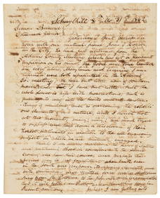
Sold1845 Virginia Slave Trade Letter: "I fear you ask too high for your girl…"1845 Virginia Slave Trade Letter: "I fear you ask too high for your girl…" ALS, 1p, measuring 7.5" x 8.5", dated May 25, 1845, Salem, VA. A letter from Sydney Hereford of Salem to one Mr. ChambeSee Sold Price
SoldAn Early Virginia Map,from an E 17th C map by Capt. John Smith, having "The Virginian Sea", "Chesapeack Bay", etc. with folds as a pull-out from a book. Matted and framed under glass, visible image 13 1/4" high, 16 1/4" wiSee Sold Price
Sold1784 hand-drawn Virginia map,Rough Sketch of 32,000 acres of land in Montgomery County in Virginia Surveyed for Mr. Levi Hollingsworth of Philadelphia in the Year 1784, signed by Dorsey Pentecost, showing 32 tracts of land alongSee Sold Price
SoldALEXANDRIA, VIRGINIA MAPALEXANDRIA, VIRGINIA MAP, engraving on paper, titled "Plan of the Town of Alexandria in the District of Columbia, 1798", a later restrike of the George Gilpin map, from the original plate engraved bySee Sold Price
ENGRAVING TITLED PRAYER IN THE DESERT AFTER PAINTING BY WILLIAM JAMES MULLER (1812-1845) – 11IN xThe Rug Life4.3(12)See Sold PriceMar 07, 2024
D'Oyly (Calcutta, India) - Procession of the CurruckpoojaTrillium Antique Prints & Rare Books4.5(30)See Sold PriceFeb 24, 2024
Vaillant - Hawaii: Stranding in the Sandwich Islands (Echouage aux Iles Sandwich). 43Trillium Antique Prints & Rare Books4.5(30)See Sold PriceFeb 24, 2024
Vaillant - Kealakekua Bay, Hawaii (Village de Kearakekoua, Iles Sandwich). 44Trillium Antique Prints & Rare Books4.5(30)See Sold PriceFeb 24, 2024
Vaillant - Honolulu, Hawaii (Vue de Honolulu, Iles Sandwich). 45Trillium Antique Prints & Rare Books4.5(30)See Sold PriceFeb 24, 2024
Vaillant - Hawaiian Dance (Scene de Danse aux Iles Sandwich). 42Trillium Antique Prints & Rare Books4.5(30)See Sold PriceFeb 24, 2024
Audubon, Imperial Folio - American Cross Fox. 6Trillium Antique Prints & Rare Books4.5(30)See Sold PriceFeb 24, 2024
Audubon, Imperial Folio - Canada Lynx. 16Trillium Antique Prints & Rare Books4.5(30)See Sold PriceFeb 24, 2024
Railways & Transport.- [Prospectus] The Dorking, Brighton, and Arundel Atmospheric Railway, byForum Auctions4.3(52)See Sold PriceFeb 29, 2024
1845 Delisle/Bauche Map of Martinique -- Carte de l'Isle de la Martinique Colonie Francoise de l'uneJasper524.5(9.8k)See Sold PriceFeb 27, 2024
Map of Yorktown - York County in Virginia - United StatesProverde Auctions4.3(3)See Sold PriceFeb 28, 2024
Mary Jane Thomas Stokes - Map of Lighthouses of the Chesapeake Bay. Past and PresentProverde Auctions4.3(3)See Sold PriceFeb 28, 2024
Virginia and West Virginia Topography MapsRapid Estate Liquidators and Auction Gallery4.5(1.1k)See Sold PriceFeb 28, 2024


![Colton's Virginia Map [Southern States] (1 of 3)](https://p1.liveauctioneers.com/5755/154409/77936948_1_x.jpg?height=282&quality=70&version=1573094011)


![Railways & Transport.- [Prospectus] The Dorking, Brighton, and Arundel Atmospheric Railway, by (1 of 1)](https://p1.liveauctioneers.com/5458/319736/171654703_1_x.jpg?height=282&quality=70&version=1708010439)