ATLAS of ANTIENT GEOGRAPHY by SAMUEL BUTLER 1843John McInnis Auctioneers,LLC4.5(505)See Sold PriceFeb 24, 2024
18TH C. ANTIQUE MAP: FRENCH & INDIAN WAR, FRAMEDThomaston Place Auction Galleries4.4(394)See Sold PriceFeb 24, 2024
Rand McNally Railroad Map Cabinet w/ 21 Railroad MapsRail & Road Auctions4.6(165)See Sold PriceMar 08, 2024
Keith Haring - Ink on New York Map, Best Buddies, Inscribed, Signed, and DatedSapphire Auction Gallery4.1(67)See Sold PriceMar 02, 2024
LATE 17TH C. FRENCH MAP OF THE NEW WORLD BY ALEXIS-HUBERT JAILLOT (1632-1712)Thomaston Place Auction Galleries4.4(394)See Sold PriceFeb 24, 2024
Central Railroad of New Jersey Map of Sandy Hook Route-ca. 1903JM Hobby Supply and Railroad Artifact Auctions4.4(127)See Sold PriceFeb 24, 2024
Lot of Six Mixed Atlas Box Cars-HO Scale-New in BoxJM Hobby Supply and Railroad Artifact Auctions4.4(127)See Sold PriceFeb 25, 2024
Rand McNally/Santa Fe Railroad Map of Iowa-1912JM Hobby Supply and Railroad Artifact Auctions4.4(127)See Sold PriceFeb 24, 2024
NICOLAES VISSCHER (NETHERLANDS, 1618-1709) MAP OF THE NEW WORLDThomaston Place Auction Galleries4.4(394)See Sold PriceFeb 24, 2024
17TH C. WORLD MAP BY NICOLAES VISSCHER (NETHERLANDS, 1618-1709)Thomaston Place Auction Galleries4.4(394)See Sold PriceFeb 24, 2024
Lot of Six Mixed Atlas Cabooses-HO Scale-New in BoxJM Hobby Supply and Railroad Artifact Auctions4.4(127)See Sold PriceFeb 25, 2024
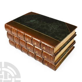
SoldPhilipp Cluver Geographium Orig 1686 Vol with MapsPhilippi Cluverii Introductionis in Universam Geographiam Tam veterem quam novam Libra VI, Amsterdam Apud Henr. Wetstenium 1686. Rare. 355 pgs plus Roman Emperors, then a printed index with a bound-inSee Sold Price
SoldCLUVER, Philipp (1580-1622) - Introductionis inCLUVER, Philipp (1580-1622) - Introductionis in universam geographiam. Amsterdam: Westenium, 1686. A copy in very good conditions. 12mo (133 x 66mm). Allegorical engraved title, 2 folding plates, 37 mSee Sold Price
[atlases] Clüver, 1686Clüver Philipp, Introductionis in universam Geographiam tam veterem quam novam Libri VI... Amstelaedami: apud Henr. Wetstenium, 1686. In-12° (mm 133x68). Pagine [12], 355, [71] con 2 tavoleSee Sold Price
SoldPhilipp Cluver map- LithuaniaPhilipp Cluver- ''Lithuania''- hand-colored copper engraving from the atlas- ''Introductionis in Universam Geogruphiam'', ca. 1676. 7 5/8 x 10 1/2''See Sold Price
SoldGrp: 11 Maps of ItalyGroup of eleven maps of Italy. Philipp Cluver map of Italy "Italiae Antiquae Delineatio" W. Poyntell & Co.; Barlow map of "Italy from the Best Authorities" C.Brightly & T.Kinnersley, Suffolk, 1806; JeSee Sold Price
SoldSitus Chorographia et Flumina Paradisi in Terra CanaaSitus Chorographia et Flumina Paradisi in Terra Canaan. An antique map of the Garden of Eden by Philipp Cluver. The map covers the region from Armenia through the Arabian Peninsula with north orientedSee Sold Price
Sold2pc Philipp Cluver, Imperii Sinarum Maps of China2pc Philipp Cluver, Imperii Sinarum Nova Descriptio Maps of China. Both have impressions measuring 8.25x10.25'', sheets measure approx 13x14.5'' and 9.5x11''. Appear to be late 17th century, however cSee Sold Price
Maps, Philipp Cluver(lot of 2) Philipp Cluver (German, 1580-1622), "Achaia quae et Hellas hodie Livadia (with inset of Athens and Thebes)," and "Chersonesi quae hodie Natolia Descriptio," 1697, hand-colored engravings, sSee Sold Price
SoldMaps, Philipp Cluver(lot of 2) Philipp Cluver (German, 1580-1622), "Veteris Cornithi," and "Macedoniae et Thessaliae Regiones," copper engraved maps with hand coloring, image (each): 7.75"h x 10"w, overall (with mat): 25See Sold Price
SoldMaps, Philipp Cluver and Sieur Robert(lot of 2) Philipp Cluver (German, 1580-1622), "Russia cum Confinijs," and Sieur Robert (French,1688-1766), "A New and Accurate Map of the Kingdom of Prussia and Polish Prussia," copper engraved mapsSee Sold Price
Maps, Philipp Cluver(lot of 2) Philipp Cluver (German, 1580-1622), "Achaia quae et Hellas hodie Livadia (with inset of Athens and Thebes)," and "Chersonesi quae hodie Natolia Descriptio," 1697, hand-colored engravings, sSee Sold Price
SoldMaps, Philipp Cluver(lot of 2) Philipp Cluver (German, 1580-1622), "Achaia quae et Hellas hodie Livadia (with inset of Athens and Thebes)," and "Chersonesi quae hodie Natolia Descriptio," 1697, hand-colored engravings, sSee Sold Price
Two maps by Philipp CluverHeading: (Cluver, Philipp) Author: Title: Helvetia [with] Persia Sive Sophorum Regnum cum Armenia, Assyria, Mesopotamia et Babylonia Place Published: No place Publisher: Date Published: No dSee Sold Price
Sold(MAP, SCANDINAVIA) CLUVER, PHILIPP 24 1/2 x 32 1/2(MAP, SCANDINAVIA) CLUVER, PHILIPP Svecia, Dania et Norvegia, from an edition of Cluver's Introductio in universalem geographiam. (Amsterdam: J. Wolters, 1697). Engraved map of Scandinavia, borders ouSee Sold Price
SoldCluver Double Hemisphere Map of the WorldTypus Orbis Terrarum. Philipp Cluver (1580-1622). Engraved map with hand color in full. Amsterdam, c. 1697. 7 1/4 x 12 1/4 inches visible, 15 1/4 x 20 1/2 inches framed. Double Hemisphere map of the wSee Sold Price
Antique Map Print - Europe - Map of Switzerland - Zurich - Philipp Cluver - 1701Title/Artist: Antique Map Print - Europe - Map of Switzerland - Zurich - Philipp Cluver - 1701 Date: 1701 Material: Paper Dimensions: 14 cm x 13 cm Additional Information: A detailed small map from &#See Sold Price
Antique Map Print - Europe - Map of Cisrhenian Germans - Philipp Cluver - 1701Title/Artist: Antique Map Print - Europe - Map of Cisrhenian Germans - Philipp Cluver - 1701 Date: 1701 Material: Paper Dimensions: 14 cm x 13 cm Additional Information: A detailed small map from RSee Sold Price
Antique Map Print - Europe - Map of Germany - Central Europe - Philipp CluverTitle/Artist: Antique Map Print - Europe - Map of Germany - Central Europe - Philipp Cluver Date/Period: 1701 Material: Paper Dimensions: 15 cm x 13 cm Description: A detailed small map from ”InSee Sold Price
Antique Map Print - Europe - Map of Low German - Hamburg - Philipp Cluver - 1701Title/Content: Antique Map Print - Europe - Map of Low German - Hamburg - Philipp Cluver - 1701 Date: 1701 Material: Paper Dimensions: 6” x 5” inches / 14 cm x 13 cm Description: A detaileSee Sold Price
SoldGrp: 7 Maps of Sicily Italy 18th/19th c. Blair ClGroup of seven maps of Sicily. Includes Rev. John Blair, "Sicilia Antiqua quae at Sicania et Trinacria dicta;" Philipp Cluver, "Siciliae Antiquae Descriptio," Leiden, 1697, which features a stunninglySee Sold Price
SoldPhilipp Cluver "Sicilia Antiqua" 1619Philipp Cluver (1580-1622), "Sicilia Antiqua; cum minoribus insulis, ei adjacentibus. Item, Sardinia et Corsica," 1619. A fine volume on historical Sicily with lovely maps. SKU: 02087See Sold Price
SoldMAP, Baltic, CluverBaltic. Philipp Cluver, Prussiae Nova Tabula, from Introductio in Universam Geographicam, 1697 (published). Hand Color. This finely engraved map covers northeastern Poland from about Gdansk to LithuanSee Sold Price
SoldMAP - Persia - Iran. CluverPersia - Iran. Philipp Cluver, Persia sive Sophorum Regnum cum Armenia Assyria Mesopotamia et Babilonia, 1711 (published). Hand Color. This charming small map covers the region from the MediterraneanSee Sold Price
SoldMAP, China, Korea & Japan, CluverChina, Korea & Japan. Philipp Cluver, Imperii Sinarum Nova Descriptio, from Introductio in Universam Geographicam, 1697 (published). Hand Color. Handsome small map based on the important Martini/BlaeuSee Sold Price
MARTINET / DE VRIES Catechism of Nature 4 Vol. Set c1788 Engravings Rare!Luis Porretta Fine Arts4.3(10)See Sold PriceMar 02, 2024
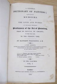
MATTHEW PILKINGTON General Dictionary Painters 2 Vol Set 1824 Calf BindingLuis Porretta Fine Arts4.3(10)See Sold PriceMar 02, 2024
WESLEY REV. JOHN Sermons On Several Occasions c1854 Full Tree Calf Vol. IILuis Porretta Fine Arts4.3(10)See Sold PriceMar 02, 2024
Archaeological Books - Roach Smith - Collectanea Antiqua, etchings and notices of ancient remains,TimeLine Auctions Ltd.4.6(184)See Sold PriceMar 06, 2024
1800 MUNGO PARK TRAVELS to AFRICA 2 VOLS w/ MAP antique in ENGLISHJasper524.5(9.9k)See Sold PriceFeb 27, 2024
1686 Theologiae Moralis by SPORER antique BLINDSTAMPED PIGSKIN 17 CENTURY Vol 3Jasper524.5(9.9k)See Sold PriceFeb 27, 2024
Fielding (Henry) The Works, with An Essay on His Life and Genius by Arthur Murphy, 10 vol., newForum Auctions4.4(54)See Sold PriceFeb 29, 2024
Nottingham.- Brown (Cornelius) Lives of Nottinghamshire Worthies, 1882; and another similar (3).Forum Auctions4.4(54)See Sold PriceFeb 29, 2024
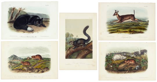
First 50 plates from Audubon's Quad Quarto (all in Vol. I)PBA Galleries4.7(389)See Sold PriceMar 07, 2024
Nearly complete set of plates from Vol. III Quad QuartoPBA Galleries4.7(389)See Sold PriceMar 07, 2024
Black and white map of part of New York City (mostly Manhattan)Proverde Auctions4.3(3)See Sold PriceFeb 28, 2024


![[atlases] Clüver, 1686 (1 of 3)](https://p1.liveauctioneers.com/1306/149409/75467384_1_x.jpg?height=282&quality=70&version=1567670708)