ATLAS of ANTIENT GEOGRAPHY by SAMUEL BUTLER 1843John McInnis Auctioneers,LLC4.6(502)See Sold PriceFeb 24, 2024
18TH C. ANTIQUE MAP: FRENCH & INDIAN WAR, FRAMEDThomaston Place Auction Galleries4.4(386)See Sold PriceFeb 24, 2024
Rand McNally Railroad Map Cabinet w/ 21 Railroad MapsRail & Road Auctions4.6(165)See Sold PriceMar 08, 2024
Keith Haring - Ink on New York Map, Best Buddies, Inscribed, Signed, and DatedSapphire Auction Gallery4(67)See Sold PriceMar 02, 2024
LATE 17TH C. FRENCH MAP OF THE NEW WORLD BY ALEXIS-HUBERT JAILLOT (1632-1712)Thomaston Place Auction Galleries4.4(386)See Sold PriceFeb 24, 2024
Central Railroad of New Jersey Map of Sandy Hook Route-ca. 1903JM Hobby Supply and Railroad Artifact Auctions4.4(126)See Sold PriceFeb 24, 2024
Lot of Six Mixed Atlas Box Cars-HO Scale-New in BoxJM Hobby Supply and Railroad Artifact Auctions4.4(126)See Sold PriceFeb 25, 2024
Rand McNally/Santa Fe Railroad Map of Iowa-1912JM Hobby Supply and Railroad Artifact Auctions4.4(126)See Sold PriceFeb 24, 2024
NICOLAES VISSCHER (NETHERLANDS, 1618-1709) MAP OF THE NEW WORLDThomaston Place Auction Galleries4.4(386)See Sold PriceFeb 24, 2024
17TH C. WORLD MAP BY NICOLAES VISSCHER (NETHERLANDS, 1618-1709)Thomaston Place Auction Galleries4.4(386)See Sold PriceFeb 24, 2024
Lot of Six Mixed Atlas Cabooses-HO Scale-New in BoxJM Hobby Supply and Railroad Artifact Auctions4.4(126)See Sold PriceFeb 25, 2024
Map European Russia 1790, Copper etchingTitle/Content of Map: Map European Russia 1790, Copper etching Date: 1790 Material/Medium: Copper etching Size: Leaf Dimension: 21,5x21 cm (8.5x8.3 inches) Engraving Dimension: 17x14,5 cm (6.7x5.7 incSee Sold Price
Map European Russia 1790, Copper etchingNice detailed map of European Russia of 1790. Date: 1790 Technique: Copper etching Leaf Dimension: 21,5x21 cm (8.5x8.3 inches) Engraving Dimension: 17x14,5 cm (6.7x5.7 inches) Conditions: Good conditiSee Sold Price
Map of Tartary Russia, Bonne, 1780, Copper etchingTitle/Content of Map: Map of Tartary Russia, Bonne, 1780, Copper etching Date: 1780 Cartographer: Rigobert Bonne (1727-1755), André Material/Medium: Copper etching Size: Leaf Dimension: 31,5x46 cm (1See Sold Price
Map of Tartary Russia, Bonne, 1780, Copper etchingVery beautiful map by Rigobert Bonne featuring Tartary Russia. Author: Rigobert Bonne (1727-1755), André Date: 1780 circa Technique: etching on copper Leaf Dimension: 31,5x46 cm (12.4x18.1 inches) EnSee Sold Price
1790 c. Bell Map of European Russia - Russia or MoscovyTitle/Content of Map: 1790 c. Bell Map of European Russia - Russia or Moscovy Date: 1790 c. Cartographer: A. Bell Size: 6.8 x 8.5 in. A nice mao of russia extending from the White Sea to the Black SeaSee Sold Price
1790 c. Bell Map of European Russia - Russia or MoscovyReserve Reduced! Title/Content of Map: 1790 c. Bell Map of European Russia - Russia or Moscovy Date: 1790 c. Cartographer: A. Bell Size: 6.8 x 8.5 in. A nice mao of russia extending from the White SeaSee Sold Price
1790 c. Bell Map of European Russia - Russia or MoscovyTitle/Content of Map: 1790 c. Bell Map of European Russia - Russia or Moscovy Date: 1790 c. Cartographer: A. Bell Size: 6.8 x 8.5 in. A nice map of Russia extending from the White Sea to the Black SeaSee Sold Price
1790 c. Bell Map of European Russia - Russia or MoscovyTitle/Content of Map: 1790 c. Bell Map of European Russia - Russia or Moscovy Date: 1790 c. Cartographer: A. Bell Size: 6.8 x 8.5 in. A nice mao of russia extending from the White Sea to the Black SeaSee Sold Price
1790 c. Bell Map of European Russia - Russia or MoscovyTitle: 1790 c. Bell Map of European Russia - Russia or Moscovy Date: 1790 c. Medium: A. Bell Size: 6.8 x 8.5 in. Additional Information: A nice map of Russia extending from the White Sea to the BlackSee Sold Price
Sold1790 c. Bell Map of European Russia - Russia or MoscovyTitle: 1790 c. Bell Map of European Russia - Russia or Moscovy Year/Place: 1790 c. Cartographer: A. Bell Size: 6.8 x 8.5 in. Additional Information: A nice map of Russia extending from the White Sea tSee Sold Price
SoldLandkarte Europaeischen Rußlands map Russiavon 1563-Kolorierte Landkarte. Radierung. 23 x 36 cm (53865005) - - Coloured map of european Russia, part of north and south. Etching. Image Size: 23 x 36 cmSee Sold Price
MAP, Russia in Europe, SansonRussia in Europe. Nicolas Sanson, Wit Ruslandt of Muskovien, 1705 (published). Black & White. Attractive copper engraved map of European Russia showing its political divisions, major topographical feaSee Sold Price
Map European Russia coloured by hand with aquarelloTitle/Content of Map: Map European Russia coloured by hand with aquarello 1870, Copper etching Date: 1870 Material/Medium: Copper etching Size: Leaf Dimension: 26x21,5 cm (10.2x8.5 inches) Engraving DSee Sold Price
Map European Russia coloured by hand with aquarelloTitle/Content of Map: Map European Russia coloured by hand with aquarello 1820, Copper etching Date: 1820 Material/Medium: Copper etching Size: Leaf Dimension: 29x44,5 cm (11.4x17.5 inches) EngravingSee Sold Price
Map of Asia 1790 Buffier Etching On CopperVery beautiful map of Asia Author: Buffier Claude (1671-1737) Atlas: Geografia Universale del Padre Claudio Buffier... (italian ediction) Date: 1790 Technique: etching on copper Leaf Dimension: 21x20See Sold Price
Antique Map of Asia 1790 Buffier Etching On CopperVery beautiful map of Asia Author: Buffier Claude (1671-1737) Atlas: Geografia Universale del Padre Claudio Buffier... (italian ediction) Date: 1790 Technique: etching on copper Leaf Dimension: 21x20See Sold Price
Map European Russia coloured by hand with aquarelloNice map of European Russia of 1820 circa coloured by hand with aquarello painting. Author: Batelli e Fanfani, M. di Pietro Date: 1820 Technique: Copper etching Leaf Dimension: 29x44,5 cm (11.4x17.5 iSee Sold Price
1790 c. Bell Map of European Russia - Russia or MoscovyTitle: 1790 c. Bell Map of European Russia - Russia or Moscovy Cartographer: A. Bell Date: 1790 c. Size: 6.8 x 8.5 in. Additional Information: A nice map of Russia extending from the White Sea to theSee Sold Price
Map European Russia coloured by hand with aquarelloNice detailed map of European Russia coloured by hand with aquarello painting of 1870 circa. Nice decorative frame. Date: 1870 circa Technique: etching on copper Leaf Dimension: 26x21,5 cm (10.2x8.5 iSee Sold Price
Sold2 English Botanicals 1790 Copper Plate Etchings SowerbyHand Colored, Dimensions: 5.5" by 9" each Plate 100 & Plate 110 BK1W25See Sold Price
Sold2 English Botanicals 1790 Copper Plate Etchings SowerbyHand Colored, Dimensions: 5.5" by 9" each Plate 78 & Plate 98 BK1W22See Sold Price
Big Map of eastern Russia in Asia and part of ChinaTitle/Content of Map: Big Map of eastern Russia in Asia and part of China coloured by hand 1750 Copper etching Robert de Vaugondy Date: 1750 Cartographer: Robert de Vaugondy Material/Medium: Copper etSee Sold Price
SoldGuthrie, William 1790 Antique Map. Russia or MuscovyCopper Engraved Map Published 1790, London for "A New Geographical, Historical and Commercial Grammar..." by William Guthrie. The maps are by John Senex, Thomas Kitchin and others. Folds as issued. EaSee Sold Price
Southern European Russia and Ukraine region. 1794 by Vaugondy/ DelamarcheTitle: Southern European Russia and Ukraine region. 1794 by Vaugondy/ Delamarche Date/Period: 1794 Materials: Hand colored copper plate engraved. Size: 16 x 11 1/2" Shows Russia centering on Moscow deSee Sold Price
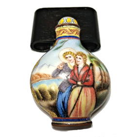
CHINESE SNUFF BOTTLE EUROPEAN SUBJECT ENAMEL ON COPPERNoble House Collection Gallery4.5(114)See Sold PriceMar 10, 2024
BEAUTIFUL CHINESE SNUFF BOTTLE EUROPEAN SUBJECT ENAMEL ON COPPERNoble House Collection Gallery4.5(114)See Sold PriceFeb 28, 2024
Antique German Kampen Town Color Copper EtchingHill Auction Gallery 4.7(1k)See Sold PriceFeb 28, 2024
[ARCTIC]. BOWEN, Emanuel. A New & Accurate Map of the North...Potter & Potter Auctions4.6(539)See Sold PriceMar 07, 2024
Johann Homann Hand-Colored Map Engraving, c. 1730Auctions at Showplace4.5(726)See Sold PriceMar 17, 2024
Two (2) Antique 18th C. Copper Engraved Framed Maps - America & EuropeMagnusson Art Group4.5(46)See Sold PriceMar 14, 2024
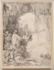
REMBRANDT VAN RIJN (1606-1669) "THE RAISING OF LAZARUS".Amelia Jeffers, Auctioneers & Appraisers4.6(101)See Sold PriceMar 07, 2024
ABRAHAM WALKOWITZ (1878-1965) "PORTRAIT OF A DANCER".Amelia Jeffers, Auctioneers & Appraisers4.6(101)See Sold PriceMar 07, 2024
1816 MAP SOUTHERN PART OF RUSSIA or MUSCOVY in EUROPE copper engraving ANTIQUEJasper524.5(9.8k)See Sold PriceFeb 27, 2024
1816 MAP NORTHERN PART OF RUSSIA or MUSCOVY in EUROPE copper engraving ANTIQUEJasper524.5(9.8k)See Sold PriceFeb 27, 2024
Churchill & Nieuhof 1744 Folio Map. Batavia Indonesia East IndiesAlbion Auctions4.6(336)See Sold PriceMar 01, 2024
Cooke, George 1801 Antique Map. United States of AmericaAlbion Auctions4.6(336)See Sold PriceMar 01, 2024
Barthelemy, Jean 1790 Map. Greece - Essa sur la Bataille de PlateeAlbion Auctions4.6(336)See Sold PriceMar 01, 2024
Barthelemy, Jean 1790 Map. Greece - Plan de L'AcademieAlbion Auctions4.6(336)See Sold PriceMar 01, 2024
Barthelemy, Jean 1790 Map. Greece - Essai sur les Environs de DelphesAlbion Auctions4.6(336)See Sold PriceMar 01, 2024


![[ARCTIC]. BOWEN, Emanuel. A New & Accurate Map of the North... (1 of 1)](https://p1.liveauctioneers.com/928/318880/171360917_1_x.jpg?height=282&quality=70&version=1707501302)