ATLAS of ANTIENT GEOGRAPHY by SAMUEL BUTLER 1843John McInnis Auctioneers,LLC4.6(504)See Sold PriceFeb 24, 2024
18TH C. ANTIQUE MAP: FRENCH & INDIAN WAR, FRAMEDThomaston Place Auction Galleries4.4(389)See Sold PriceFeb 24, 2024
Rand McNally Railroad Map Cabinet w/ 21 Railroad MapsRail & Road Auctions4.6(165)See Sold PriceMar 08, 2024
Keith Haring - Ink on New York Map, Best Buddies, Inscribed, Signed, and DatedSapphire Auction Gallery4.1(67)See Sold PriceMar 02, 2024
LATE 17TH C. FRENCH MAP OF THE NEW WORLD BY ALEXIS-HUBERT JAILLOT (1632-1712)Thomaston Place Auction Galleries4.4(389)See Sold PriceFeb 24, 2024
Central Railroad of New Jersey Map of Sandy Hook Route-ca. 1903JM Hobby Supply and Railroad Artifact Auctions4.4(126)See Sold PriceFeb 24, 2024
Lot of Six Mixed Atlas Box Cars-HO Scale-New in BoxJM Hobby Supply and Railroad Artifact Auctions4.4(126)See Sold PriceFeb 25, 2024
Rand McNally/Santa Fe Railroad Map of Iowa-1912JM Hobby Supply and Railroad Artifact Auctions4.4(126)See Sold PriceFeb 24, 2024
NICOLAES VISSCHER (NETHERLANDS, 1618-1709) MAP OF THE NEW WORLDThomaston Place Auction Galleries4.4(389)See Sold PriceFeb 24, 2024
17TH C. WORLD MAP BY NICOLAES VISSCHER (NETHERLANDS, 1618-1709)Thomaston Place Auction Galleries4.4(389)See Sold PriceFeb 24, 2024
Lot of Six Mixed Atlas Cabooses-HO Scale-New in BoxJM Hobby Supply and Railroad Artifact Auctions4.4(126)See Sold PriceFeb 25, 2024
SoldThree Hand Colored MapsAll are from atlases, Sweden, Denmark, Norway, and Finland by S. Hill Boston circa 1810. Two maps from England, Cambridgeshire and Huntingdonshire by Thomas Moule circa 1840. Dimensions are: Largest ISee Sold Price
SoldThree hand colored maps, one of Neapel, Ferd. GöeThree hand colored maps, one of Neapel, Ferd. Göetz, 1810; one Persian, C.G. Reighard 1804; one Zeichen Erklaerung, 24'' x 27 1/2''.See Sold Price
SoldThree hand colored maps of Dutchess County areaThree hand colored maps of Dutchess County area including a Beers map of Unionvale, and 2 of Dutchess itself. All circa 1860-70.See Sold Price
SoldTwo Maps by Abraham Ortelius (1527-1598), "PeruviaeTwo Maps by Abraham Ortelius (1527-1598), "Peruviae Auriferae Regionis Typus, La Florida Aue Torre Hieron Chiaues, Guastecan Reg," each containing three hand colored maps on two sheets, 1595, hand colSee Sold Price
SoldGrp: 3 Matthaus Seutter Maps of Italy Tuscany ManMatthaus Seutter (1678-1757) Group of three hand colored maps including a map of Tuscany, a map of Mantua, and a map of Modena. All with exquisitely detailed cartouches featuring groups of figures. SKSee Sold Price
SoldJohn Cary 1806, Three Maps of North AmericaThree hand colored maps of North America by John Cary, London, 1806. 1st map - "A New Map of North America" showing continent of North America. 2nd map - "A New Map of Part of the United States contaiSee Sold Price
Sold(MAP, SOUTH AMERICA) Size of largest frame 23 1/2 x(MAP, SOUTH AMERICA) A group of three hand-colored maps of South America. Chili. (Amsterdam, 1640). A copper engraved hand-colored map of Chili. Text to verso. Small tear to right edge; otherwise fineSee Sold Price
SoldThree Hand Colored Pocket MapsComprising Pennsylvania and New Jersey by H.S Tanner Philadelphia 1827, Tourist Map of New York State by William Williams 1828 and Township Map of the State of New York published by JH Colton New YorkSee Sold Price
SoldThree European Hand-Colored MapsThree Antique European Hand-Colored Maps , 18th c., incl.: "The Countie and Citie of Lyncolne Described with the Armes...", 15 in. x 20 in.; "Istria olim Iapidia", 15 in. x 19 1/2 in.; and "PrincipatuSee Sold Price
SoldThree Antique Hand Colored MapsA grouping of three antique hand-colored engraved maps to include a 1642 map of America, a 1794 Laurie and Whittle plan of a Puerto Cavello, and a Laurie and Whittle plan of the Road and Town of La GuSee Sold Price
SoldThree hand colored engraved maps by Van Den KeereThree hand colored engraved maps by Van Den Keere including Europa, New and Accurate Map of the World, and Africa, pocket size. 3 3/4" x 5 1/4" Provenance: Property from the Credit Suisse AmericanSee Sold Price
SoldThree Hand Colored, Engraved Maps from Mitchell'sThree Hand Colored, Engraved Maps from Mitchell's General Atlas (1862), Pages 14, 15, 24.Includes:Map of New Hampshire and Vermont (1862);Map of Massachusetts, Connecticut and Rhode Island (1862;PlanSee Sold Price
Three American hand colored maps77. Three American hand colored maps: Goshen, circa 1860, 16 ½ x 13 ½ in, Patterson/Brewster’s station, circa 1860, 16 ¾ x 13 ½ in., and Mamaroneck, Scarsdale, White Plains, Harrison & Rye, 1867See Sold Price
SoldThree Antique Hand-Colored Maps"Graecia Cum Insulis Et Oris Maris Aegaei (Greece with Islands and the Coast of Aegean Sea)." From Atlas Antiquus By Dr. Henry Kiepert Edition Published in 1900. Hand colored boundaries. Latinized namSee Sold Price
SoldThree hand colored engraved maps by Van Den KeereThree hand colored engraved maps by Van Den Keere including Europa, New and Accurate Map of the World, and Africa, pocket size.See Sold Price
SoldThree Framed Hand-Colored Maps[A New and Accurat Map of the World], by P. Kaerius/John Speed, Amsterdam, circa 1646, miniature version, 3-3/8 x 4-7/8 in. (sight), [toning]; [Tiipus Orbis Terrarum] by Phillipe Galle, circa 1574, thSee Sold Price
SoldGROUP THREE ANTIQUE HAND-COLORED MAPS18th c. Sicily ( 10.25 x 13.5" margins cut), 18th c. Middle East (17.25 x 21.5"), and greater Caspian Sea (19.5 x 25" with taped margins). All unframed.See Sold Price
SoldJacques Nicolas Bellin 1764Jacques Nicolas Bellin, "La Louisiane et Pays Voisins", "Cours du Fleuve Saint Louis...", "Plan de la Nouvelle Orleans", three hand-colored engraved maps (plates 40, 43 and 45), from Le Petit Atlas MaSee Sold Price
SoldThree Hand-Colored Engraved US MapsThree Hand-Colored Engraved Maps of the United States of America, 1791-1874 including a "Map of the United States with Part of the Adjoining Provinces...", by Robert Wilkinson, engraved by Thomas CondSee Sold Price
Abraham Ortelius map of Latin America Belgian (152Abraham Ortelius map of Latin America Belgian (1527-1598) "Peruviae Auriferae Regionis Typus -- La Florida -- Guastecan Reg[io]" [Antwerp, c.1584 or later]; three hand-colored engraved maps on one sheSee Sold Price
SoldThree Early Maps of the Mouth of the MississippiGroup of Three Hand-Colored Engraved Maps of the Mouth of the Mississippi River from Pierre-Francois Xavier Charlevoix's Histoire et Description Generale de la Nouvelle France by Jacques-Nicolas BelliSee Sold Price
Sold[West Virginia, Oil Maps, c. 1850]A collection of three hand-colored manuscript maps of oil tracts in West Virginia, ink and watercolor on onion-skin linen, c.1850, including: *** "Oil Tract in Gilmer County, W. Va.," 248 x 319 mm, soSee Sold Price
SoldThree 1835 Hand Colored Celestial Maps. Engravedby W.G. Evans and Hartford. Published by E.J. Huntington. From a series of decorative celestial maps. Dimensions: 13.75" x 13.75." Condition: Age appropriate, small stains, creases but generally good.See Sold Price
SoldThree 17th century hand colored maps including: 1)Three 17th century hand colored maps including: 1) Antiquorum Italiae & Illyrici Occidentalis Episcopatum Geographica Descripto – published by M. Tavernier, Paris 1640 – some foxing otherwise verySee Sold Price
WILLEM JANSZOON BLAEU (NETHERLANDS, 1571-1638) MAP OF UMBRIAThomaston Place Auction Galleries4.4(389)See Sold PriceFeb 24, 2024
MARTIN VILLALBA Three Baristas Limited Ed 11/50 Engraving Hand ColoredLuis Porretta Fine Arts4.3(10)See Sold PriceMar 02, 2024
VENET / DEBUCOURT (1755-1832) Set 3 x Aquatint Engraved Hunting Scenes 23" x 16"Luis Porretta Fine Arts4.3(10)See Sold PriceMar 02, 2024
MAP - PIETER SCHENK / VALK / JANSSEN Hand Colored superb Map Central Italy c1702Luis Porretta Fine Arts4.3(10)See Sold PriceMar 02, 2024
PIETER SCHENK / VALK / JANSSEN Hand Colored Map of Rhodes Greece ca1702 vgcLuis Porretta Fine Arts4.3(10)See Sold PriceMar 02, 2024
Hand Colored Map of the city of Amsterdam 1720Global Auctions Company4.3(36)See Sold PriceMar 03, 2024
[CHICAGO]. Rare Pre-Fire Illinois Map: “Blanchard’s Map of ...Potter & Potter Auctions4.6(544)See Sold PriceMar 07, 2024
[MAPS]. DUFOUR, Auguste-Henri (1795-1865). Bound Volume of ...Potter & Potter Auctions4.6(544)See Sold PriceMar 07, 2024
[MAP]. [ALBRIZZI, Giambatista, 1698-1777]. Carta Geografica...Potter & Potter Auctions4.6(544)See Sold PriceMar 07, 2024
Johann Homann Hand-Colored Map Engraving, c. 1730Auctions at Showplace4.6(731)See Sold PriceMar 17, 2024
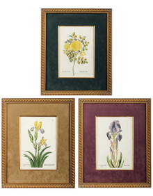
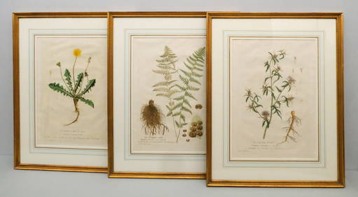
Georg Wolfgang Knorr (German, 1705-1761), Three Antique Hand Colored Botanical Engravings ofHoch LTD.4.5(74)See Sold PriceFeb 25, 2024
Pascal's Collection de fleurs... - Volume with 48 Originally Hand-colored LithographsTrillium Antique Prints & Rare Books4.5(30)See Sold PriceFeb 24, 2024
THREE HAND COLORED AND ADORNED PRINTS.Amelia Jeffers, Auctioneers & Appraisers4.5(116)See Sold PriceMar 08, 2024
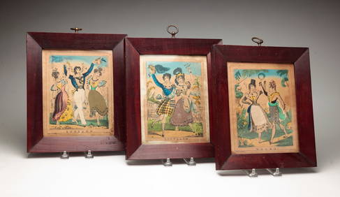
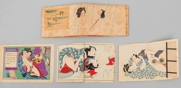
Japanese School, Handmade Shunga BookletOld Kinderhook Auction Company4.6(217)See Sold PriceMar 05, 2024
Rare 19thc Colton Map, Argentine Republic, Chile, Uruguay, PataguayConnoisseur Auctions3.9(335)See Sold PriceMar 16, 2024
Galliae Regionis Nova Descriptio Hand Colored Map of France on Laid Paper, Ca. 16th Century, H 10" WDuMouchelles4.6(829)See Sold PriceMar 15, 2024


![[West Virginia, Oil Maps, c. 1850] (1 of 5)](https://p1.liveauctioneers.com/3532/111460/57224277_1_x.jpg?height=282&quality=70&version=1509131847)


![[CHICAGO]. Rare Pre-Fire Illinois Map: “Blanchard’s Map of ... (1 of 2)](https://p1.liveauctioneers.com/928/318880/171361260_1_x.jpg?height=282&quality=70&version=1707501302)
![[MAPS]. DUFOUR, Auguste-Henri (1795-1865). Bound Volume of ... (1 of 2)](https://p1.liveauctioneers.com/928/318880/171361279_1_x.jpg?height=282&quality=70&version=1707501302)
![[MAP]. [ALBRIZZI, Giambatista, 1698-1777]. Carta Geografica... (1 of 1)](https://p1.liveauctioneers.com/928/318880/171361280_1_x.jpg?height=282&quality=70&version=1707501302)