ATLAS of ANTIENT GEOGRAPHY by SAMUEL BUTLER 1843John McInnis Auctioneers,LLC4.5(505)See Sold PriceFeb 24, 2024
18TH C. ANTIQUE MAP: FRENCH & INDIAN WAR, FRAMEDThomaston Place Auction Galleries4.4(393)See Sold PriceFeb 24, 2024
Rand McNally Railroad Map Cabinet w/ 21 Railroad MapsRail & Road Auctions4.6(165)See Sold PriceMar 08, 2024
Keith Haring - Ink on New York Map, Best Buddies, Inscribed, Signed, and DatedSapphire Auction Gallery4(67)See Sold PriceMar 02, 2024
LATE 17TH C. FRENCH MAP OF THE NEW WORLD BY ALEXIS-HUBERT JAILLOT (1632-1712)Thomaston Place Auction Galleries4.4(393)See Sold PriceFeb 24, 2024
Central Railroad of New Jersey Map of Sandy Hook Route-ca. 1903JM Hobby Supply and Railroad Artifact Auctions4.4(127)See Sold PriceFeb 24, 2024
Lot of Six Mixed Atlas Box Cars-HO Scale-New in BoxJM Hobby Supply and Railroad Artifact Auctions4.4(127)See Sold PriceFeb 25, 2024
Rand McNally/Santa Fe Railroad Map of Iowa-1912JM Hobby Supply and Railroad Artifact Auctions4.4(127)See Sold PriceFeb 24, 2024
NICOLAES VISSCHER (NETHERLANDS, 1618-1709) MAP OF THE NEW WORLDThomaston Place Auction Galleries4.4(393)See Sold PriceFeb 24, 2024
17TH C. WORLD MAP BY NICOLAES VISSCHER (NETHERLANDS, 1618-1709)Thomaston Place Auction Galleries4.4(393)See Sold PriceFeb 24, 2024
Lot of Six Mixed Atlas Cabooses-HO Scale-New in BoxJM Hobby Supply and Railroad Artifact Auctions4.4(127)See Sold PriceFeb 25, 2024
Whipple: Antique Map of Arkansas & Indian TerritoryTitle/Content of Map: 1853-4 Whipple Map of Parts of Arkansas, Indian Territory, Texas and New Mexico -- Map No. 1 From Fort Smith to the Rio Grande…under the direction of the Hon. Jefferson Davis,See Sold Price
Whipple: Antique Map of Arkansas, Indian Territory 1853Title/Content of Map: 1853-4 Whipple Map of Parts of Arkansas, Indian Territory, Texas and New Mexico -- Map No. 1 From Fort Smith to the Rio Grande…under the direction of the Hon. Jefferson DavSee Sold Price
Whipple: Antique Map Arkansas, Indian Territory, 1853-4Title/Content of Map: 1853-4 Whipple Map of Parts of Arkansas, Indian Territory, Texas and New Mexico -- Map No. 1 From Fort Smith to the Rio Grande…under the direction of the Hon. Jefferson Davis,See Sold Price
1853-4 Whipple Map of Parts of Arkansas, IndianTitle/Content of Map: 1853-4 Whipple Map of Parts of Arkansas, Indian Territory, Texas and New Mexico -- Map No. 1 From Fort Smith to the Rio Grande…under the direction of the Hon. Jefferson Davis,See Sold Price
1853-4 Whipple Map of Parts of Arkansas, IndianTitle/Content of Map: 1853-4 Whipple Map of Parts of Arkansas, Indian Territory, Texas and New Mexico -- Map No. 1 From Fort Smith to the Rio Grande…under the direction of the Hon. Jefferson Davis,See Sold Price
1853-4 Whipple Map of Parts of Arkansas, IndianTitle/Content of Map: 1853-4 Whipple Map of Parts of Arkansas, Indian Territory, Texas and New Mexico -- Map No. 1 From Fort Smith to the Rio Grande…under the direction of the Hon. Jefferson Davis,See Sold Price
1853-4 Whipple Map of Parts of Arkansas, IndianTitle/Content of Map: 1853-4 Whipple Map of Parts of Arkansas, Indian Territory, Texas and New Mexico -- Map No. 1 From Fort Smith to the Rio Grande…under the direction of the Hon. Jefferson Davis,See Sold Price
1853-4 Whipple Map of Arkansas, Indian TerritoryTitle/Content of Map: 1853-4 Whipple Map of Parts of Arkansas, Indian Territory, Texas and New Mexico -- Map No. 1 From Fort Smith to the Rio Grande…under the direction of the Hon. Jefferson Davis,See Sold Price
Sold1853-4 Whipple Map of Parts of Arkansas, IndianTitle: 1853-4 Whipple Map of Parts of Arkansas, Indian Territory, Texas and New Mexico -- Map No. 1 From Fort Smith to the Rio Grande…under the direction of the Hon. Jefferson Davis, Secretary of WaSee Sold Price
1853-4 Whipple Map of Parts of Arkansas, IndianTitle/Content of Map: 1853-4 Whipple Map of Parts of Arkansas, Indian Territory, Texas and New Mexico -- Map No. 1 From Fort Smith to the Rio Grande…under the direction of the Hon. Jefferson Davis,See Sold Price
Antique Botanical Profile Map for Pacific RR, 1853-4Title: 1853-4 Botanical Profile Map for Pacific RR Through New Mexico and Parts of Arizona -- Botanical Profile Representing the Forest Trees Along the Route Explored by Lieut. A. W. Whipple, Corps ofSee Sold Price
Antique Botanical Profile Map for Pacific Railraod 1853Map: 1853-4 Botanical Profile Map for Pacific RR Through New Mexico and Parts of Arizona -- Botanical Profile Representing the Forest Trees Along the Route Explored by Lieut. A. W. Whipple, Corps of TSee Sold Price
SoldTEXAS C. 1886 MAP, PART OF INDIAN TERRITORYFramed map of Texas, c. 1886, showing counties with an inset for the Panhandle and a portion of the Indian Territory (Cheyennes, Arrapahoes), sight: 11.75"h, 17"w, overall: 21.75"h, 25.75"w, 4.25lbs SSee Sold Price
SoldAN ANTIQUE POSTAL MAP, "Post Route Map of the State ofAN ANTIQUE POSTAL MAP, "Post Route Map of the State of Texas with adjacent parts of Louisiana, Arkansas, Indian Territory, and the Republic of Mexico," CIRCA 1878, hand colored lithograph on paper, "DSee Sold Price
SoldFort Smith to the Rio Grande 1853-4Map No. 1 From Fort Smith to the Rio Grande by Lieut. A. W. Whipple 1853-4. In a protective gold tooled leather holderSee Sold Price
1853-4 Botanical Profile Map for Pacific RRItem: 1853-4 Botanical Profile Map for Pacific RR Description: 1853-4 Botanical Profile Map for Pacific RR Through New Mexico and Parts of Arizona -- Botanical Profile Representing the Forest Trees AlSee Sold Price
Botanical Profile Map Pacific RR, New Mexico & ArizonaTitle/Content of Map: 1853-4 Botanical Profile Map for Pacific RR Through New Mexico and Parts of Arizona -- Botanical Profile Representing the Forest Trees Along the Route Explored by Lieut. A. W. WhSee Sold Price
Sold1853-4 Botanical Profile Map for Pacific RR Through NewTitle/Content of Map: 1853-4 Botanical Profile Map for Pacific RR Through New Mexico and Parts of Arizona -- Botanical Profile Representing the Forest Trees Along the Route Explored by Lieut. A. W. WhSee Sold Price
1853-4 Botanical Profile Map for Pacific RR Through NewTitle/Content of Map: 1853-4 Botanical Profile Map for Pacific RR Through New Mexico and Parts of Arizona -- Botanical Profile Representing the Forest Trees Along the Route Explored by Lieut. A. W. WhSee Sold Price
1853-4 Botanical Profile Map for Pacific RR Through NewTitle/Content of Map: 1853-4 Botanical Profile Map for Pacific RR Through New Mexico and Parts of Arizona -- Botanical Profile Representing the Forest Trees Along the Route Explored by Lieut. A. W. WhSee Sold Price
Sold1853 No. 4 United States, BurgessInteresting map of the Atlantic states from Mitchell’s 1853 School Atlas published by Thomas, Cowperthwait & Co. The map is copyrighted by Daniel Burgess. In this map West Virginia is still part ofSee Sold Price
Map of Arkansas, Louisiana, Mississippi 1853Map of Arkansas, Louisiana, Mississippi and partials of Indian Territory and Texas Hand colored. Map No 6 United States Cartographer: Jules Sherman Smith Publisher Daniel Burgess DSee Sold Price
Sold4 Volumes - War of the Rebellion4 Volumes of The War of the Rebellion Including Vol. XXII Parts 1 & 2 Operations in Missouri, Arkansas, Kansas, the Indian Territory, and the Department of the Northwest, Nov. 20, 1862 - Dec. 31, 1863See Sold Price
Royal Grant to Sir Johnson to Indian Children 1797A Map of Part of the Land in the Royal Grant Revised by Sir William Johnson to some of his Natural Indian Children Surveyed by Lawrence Vernoon 1797 Print Type: EngravSee Sold Price
Cleveland and Mahoning RR 2nd Annual Report-December 20, 1854JM Hobby Supply and Railroad Artifact Auctions4.4(127)See Sold PriceFeb 24, 2024
Oregon Short Line RR April 1899 Public TimetableJM Hobby Supply and Railroad Artifact Auctions4.4(127)See Sold PriceFeb 24, 2024
18TH C. ANTIQUE MAP: FRENCH & INDIAN WAR, FRAMEDThomaston Place Auction Galleries4.4(393)See Sold PriceFeb 24, 2024
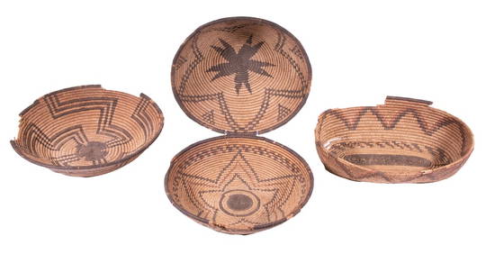
(4) NORTHWEST NATIVE AMERICAN BASKETSThomaston Place Auction Galleries4.4(393)See Sold PriceFeb 25, 2024
DEVINE c1856 Dr Salters Map Of Lake Huron Ontario Indian Lands etc. No. 7 ScarceLuis Porretta Fine Arts4.3(10)See Sold PriceMar 02, 2024
MATTHEWS c1856 Map Of Upper Canada Ontario Indian Land Agency Divisions Scarce!Luis Porretta Fine Arts4.3(10)See Sold PriceMar 02, 2024
Map: A 19thC engraved map of West Riding, titled A Map of the North Part of the West Riding ofClaydon Auctioneers Ltd4.3(125)See Sold PriceFeb 26, 2024
1749 MAP CARTE DE LA TARTARIE ORIENTALE RUSSIA & CHINA antique EASTERN TARTARYJasper524.5(9.9k)See Sold PriceFeb 27, 2024
1558 SCANDINAVIA SWEDEN ILLUSTRATED HISTORY Gothorum Sveonumque historia antiqueJasper524.5(9.9k)See Sold PriceFeb 27, 2024
1709 GREEK BIBLE ILLUSTRATED w/ MAPS antique VELLUM BOUND Septuagint editionJasper524.5(9.9k)See Sold PriceFeb 27, 2024
Emory's Notes of a Military Reconnoissance larger issuePBA Galleries4.7(385)See Sold PriceMar 07, 2024
Whipple & Sibley Native American Art Hand Painted By Jody In Jackson HoleRapid Estate Liquidators and Auction Gallery4.5(1.1k)See Sold PriceFeb 24, 2024
Vintage Indian Wood Elephant CarvingRapid Estate Liquidators and Auction Gallery4.5(1.1k)See Sold PriceFeb 24, 2024
Framed Tropical West Indies Map PrintRapid Estate Liquidators and Auction Gallery4.5(1.1k)See Sold PriceFeb 26, 2024
Framed Vintage Map Of Le Port Au Prince In The Island Of Santo DomingoRapid Estate Liquidators and Auction Gallery4.5(1.1k)See Sold PriceMar 01, 2024
Laminated Unique Media The World Map 1996 EditionRapid Estate Liquidators and Auction Gallery4.5(1.1k)See Sold PriceMar 02, 2024