ATLAS of ANTIENT GEOGRAPHY by SAMUEL BUTLER 1843John McInnis Auctioneers,LLC4.5(505)See Sold PriceFeb 24, 2024
18TH C. ANTIQUE MAP: FRENCH & INDIAN WAR, FRAMEDThomaston Place Auction Galleries4.4(394)See Sold PriceFeb 24, 2024
Rand McNally Railroad Map Cabinet w/ 21 Railroad MapsRail & Road Auctions4.6(165)See Sold PriceMar 08, 2024
Keith Haring - Ink on New York Map, Best Buddies, Inscribed, Signed, and DatedSapphire Auction Gallery4.1(67)See Sold PriceMar 02, 2024
LATE 17TH C. FRENCH MAP OF THE NEW WORLD BY ALEXIS-HUBERT JAILLOT (1632-1712)Thomaston Place Auction Galleries4.4(394)See Sold PriceFeb 24, 2024
Central Railroad of New Jersey Map of Sandy Hook Route-ca. 1903JM Hobby Supply and Railroad Artifact Auctions4.4(127)See Sold PriceFeb 24, 2024
Lot of Six Mixed Atlas Box Cars-HO Scale-New in BoxJM Hobby Supply and Railroad Artifact Auctions4.4(127)See Sold PriceFeb 25, 2024
Rand McNally/Santa Fe Railroad Map of Iowa-1912JM Hobby Supply and Railroad Artifact Auctions4.4(127)See Sold PriceFeb 24, 2024
NICOLAES VISSCHER (NETHERLANDS, 1618-1709) MAP OF THE NEW WORLDThomaston Place Auction Galleries4.4(394)See Sold PriceFeb 24, 2024
17TH C. WORLD MAP BY NICOLAES VISSCHER (NETHERLANDS, 1618-1709)Thomaston Place Auction Galleries4.4(394)See Sold PriceFeb 24, 2024
Lot of Six Mixed Atlas Cabooses-HO Scale-New in BoxJM Hobby Supply and Railroad Artifact Auctions4.4(127)See Sold PriceFeb 25, 2024
Geographical and Statistical Map of Turkey, 1820Title/Content of Map: Geographical, Historical, and Statistical Map of Turkey. Cartographer: GROS, C./J. YEAGER Size: 8.5X18.25 "Turkey in Europe and Asia. Including the places celebrated for battlesSee Sold Price
Lavoisne: Geographical & Statistical Map of France 1820Map: Geographical and Statistical Map of France Cartographer: M. Lavoisne Date: 1820 Origin: Philadelphia Size: 16.5 x 20.5 inches Colorful map of France. This Copper Plate map shows geographical featSee Sold Price
SoldGEOGRAPHICAL & STATISTICAL MAP OF RUSSIA 1820The Russian Empire after the fall of Napolean 1820 by M. Carey & Son, hand-colored map surrounded by statistical data. Sight size 16.5 x 21 inches, overall 26.75 x 29.See Sold Price
SoldGeographical and Statistical Map of Turkey.Title: Geographical and Statistical Map of Turkey. Publication Date: 1822 Cartographer: GROS, C./J. YEAGER Publisher: M. CAREY Size: 8.25Height - 17.75Width Restriking of Gros's Map of Turkey in EuropSee Sold Price
Geographical and Statistical Map of Turkey.Title/Content of Map: Geographical and Statistical Map of Turkey. Cartographer: GROS, C./J. YEAGER Date: 1822 Publisher: M. CAREY Size: 8.25Height - 17.75Width Restriking of Gros's Map of Turkey in EuSee Sold Price
Geographical and Statistical Map of Turkey.Title/Content of Map: Geographical and Statistical Map of Turkey. Date: 1822 Cartographer: GROS, C./J. YEAGER Size: 8.25x17.75 Restriking of Gros's Map of Turkey in Europe and Turkey in Asia... intendSee Sold Price
Geographical and Statistical Map of Russia, 1820Map: Geographical and Statistical Map of Russia. Publication Date: 1820 Authors: M. CAREY & SON, GROS, C. Publisher: M. CAREY & SON Size: Quarto – 10.25 H x 15.25 W Inches "Map of the Russian EmpireSee Sold Price
Geographical and Statistical Map of Ireland, 1820Title/Content of Map: Geographical and Statistical Map of Ireland. Ireland; Drawn from the Best Authorities Date Printed: 1820 Cartographer: ASPIN, JEHOSHOPHAT Size (inches): 10.75x14.25 "for the illuSee Sold Price
Geographical and Statistical Map of Scotland, 1820Title/Content of Map: Geographical and Statistical Map of Scotland. Scotland: Drawn from the Best Authorities Date Printed: 1820 Cartographer: ASPIN, JEHOSHOPHAT Size (inches): 8.5x18.25 "for the illuSee Sold Price
Geographical and Statistical Map of France, 1820Title/Content of Map: Geographical and Statistical Map of France. Map of France. Divided Into Governments Date Printed: 1820 Cartographer: GROS, C. Size (inches): 14x11.5 "indicating the places renderSee Sold Price
Geographical and Statistical Map of China, 1820Title/Content of Map: Geographical and Statistical Map of China. Date Printed: 1820 Cartographer: GROS, C. Size (inches): 14.1x11.75 "China and the tributary kingdom of Corea. For the elucidation of LSee Sold Price
Geographical, Historical, and Statistical Map of TurkeyTitle/Content of Map: Geographical, Historical, and Statistical Map of Turkey. Date Printed: 1820 Cartographer: GROS, C./J. YEAGER Size (inches): x9.75 "Turkey in Europe and Asia. Including the placesSee Sold Price
Geographical and Statistical Map of Russia, 1820Title/Content of Map: Geographical and Statistical Map of Russia. Date Printed: 1820 Cartographer: GROS, C. Size (inches): 13.25x12.25 "Map of the Russian Empire. intended for the elucidation of LavoiSee Sold Price
1820 Lavoisne Map of France -- Geographical andReserve Reduced! Title/Content of Map: 1820 Lavoisne Map of France -- Geographical and Statistical Map of France Date: 1820 Philadelphia Cartographer: M. Lavoisne Size: 16.5 x 20.5 in. Colorful map ofSee Sold Price
Geographical, Historical, and Statistical Map ofMap Title: Geographical, Historical, and Statistical Map of Turkey. Publication Date: 1820Cartographer: GROS, C./J. YEAGER Publisher: MATHEW CAREY Size: 8.5 X 18.25 "Turkey in Europe and Asia. IncludiSee Sold Price
1820 Lavoisne Map of France -- Geographical andTitle/Content of Map: 1820 Lavoisne Map of France -- Geographical and Statistical Map of France Date: 1820 Philadelphia Cartographer: M. Lavoisne Size: 16.5 x 20.5 Colorful map of France. This CopperSee Sold Price
1820 Lavoisne Map of France -- Geographical andTitle/Content of Map: 1820 Lavoisne Map of France -- Geographical and Statistical Map of France Date: 1820 Philadelphia Cartographer: M. Lavoisne Size: 16.5 x 20.5 in. Colorful map of France. This CopSee Sold Price
1820 Lavoisne Map of France -- Geographical andTitle/Content of Map: 1820 Lavoisne Map of France -- Geographical and Statistical Map of France Date: 1820 Philadelphia Cartographer: M. Lavoisne Size: 16.5 x 20.5 Colorful map of France. This CopperSee Sold Price
Geographical, Historical, and Statistical Map ofMap: Geographical, Historical, and Statistical Map of Turkey. Date: 1820 Cartographer: GROS, C./J. YEAGER Publisher: MATHEW CAREY Size (inches): 8.5X18.25 "Turkey in Europe and Asia. Including the plaSee Sold Price
Lavoisne: Antique Map of France, 1820Title/Content of Map: 1820 Lavoisne Map of France -- Geographical and Statistical Map of France Date Printed: 1820 Philadelphia Cartographer: M. Lavoisne Size: 16.5 x 20.5 in. Colorful map of France.See Sold Price
Lavoisne: Antique Map of France, 1820Map: 1820 Lavoisne Map of France -- Geographical and Statistical Map of France Date Printed: 1820 Philadelphia Cartographer: M. Lavoisne Size: 16.5 x 20.5 in. Condition: Very good, slight age toning oSee Sold Price
1820 Lavoisne Map of Spain and Portugal -- GeographicalTitle/Content of Map: 1820 Lavoisne Map of Spain and Portugal -- Geographical and Statistical Map of Spain and Portugal Date: 1820 c. Philadelphia Cartographer: M. Lavoisne Size: 16.5 x 20.5 in. ColorSee Sold Price
1820 Lavoisne Map of Spain and Portugal -- Geographical1820 Lavoisne Map of Spain and Portugal -- Geographical and Statistical Map of Spain and Portugal 1820 c. Philadelphia M. Lavoisne 16.5 x 20.5 in. Colorful map of Spain and Portugal. This Copper PlateSee Sold Price
1820 Lavoisne Map of Spain and Portugal -- GeographicalTitle/Content of Map: 1820 Lavoisne Map of Spain and Portugal -- Geographical and Statistical Map of Spain and Portugal Date: 1820 c. Philadelphia Cartographer: M. Lavoisne Size: 16.5 x 20.5 in. ColorSee Sold Price
Nova Totius Full Color Geographical World MapThe Benefit Shop Foundation Inc.4.3(3k)See Sold PriceFeb 28, 2024
Vintage County Map Of NY State Plate EngravingThe Benefit Shop Foundation Inc.4.3(3k)See Sold PriceFeb 28, 2024
Vintage Framed Pine Island & Lacoste Island MapThe Benefit Shop Foundation Inc.4.3(3k)See Sold PriceMar 06, 2024
1822 MAP of LEEWARD ISLANDS GEOGRAPHICAL STATISTICAL HISTORICAL antique 17.5x22"Jasper524.5(9.9k)See Sold PriceFeb 27, 2024
1822 MAP of SOUTH AMERICA GEOGRAPHICAL STATISTICAL HISTORICAL antique 17.5x 22"Jasper524.5(9.9k)See Sold PriceFeb 27, 2024
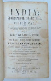
1858 INDIA HISTORY ILLUSTRATED antique Geographical, Statistical, and HistoricalJasper524.5(9.9k)See Sold PriceFeb 27, 2024
1822 MAP of NORTH & SOUTH AMERICA GEOGRAPHICAL STATISTICAL HISTORICAL antiqueJasper524.5(9.9k)See Sold PriceFeb 27, 2024
1822 MAP of CHILI GEOGRAPHICAL STATISTICAL HISTORICAL antique 17.5x 22" CHILEJasper524.5(9.9k)See Sold PriceFeb 27, 2024
Geographical, Statistical, and Historical Map of the Leeward Islands.Jasper524.5(9.9k)See Sold PriceFeb 27, 2024
Geographical Statistical and Historical Map of the Windward IslandsJasper524.5(9.9k)See Sold PriceFeb 27, 2024
Geographical, Statistical, and Historical Map of the West Indies.Jasper524.5(9.9k)See Sold PriceFeb 27, 2024
Stanford, Edward 1901 Large Map. Sea of Marmara. TurkeyAlbion Auctions4.7(341)See Sold PriceMar 01, 2024
Rees & Macpherson 1820 Lot of 6 Ancient Geography MapsAlbion Auctions4.7(341)See Sold PriceMar 01, 2024
Framed Vintage Style Visscher Commander Repro MapRapid Estate Liquidators and Auction Gallery4.5(1.1k)See Sold PriceMar 01, 2024
Map of Turkey from Arabic and Persia, 1701 by Gillaume de Lisle, ParisAntiques Online Auctions4.6(419)See Sold PriceMar 14, 2024