ATLAS of ANTIENT GEOGRAPHY by SAMUEL BUTLER 1843John McInnis Auctioneers,LLC4.5(505)See Sold PriceFeb 24, 2024
18TH C. ANTIQUE MAP: FRENCH & INDIAN WAR, FRAMEDThomaston Place Auction Galleries4.4(393)See Sold PriceFeb 24, 2024
Rand McNally Railroad Map Cabinet w/ 21 Railroad MapsRail & Road Auctions4.6(165)See Sold PriceMar 08, 2024
Keith Haring - Ink on New York Map, Best Buddies, Inscribed, Signed, and DatedSapphire Auction Gallery4.1(67)See Sold PriceMar 02, 2024
LATE 17TH C. FRENCH MAP OF THE NEW WORLD BY ALEXIS-HUBERT JAILLOT (1632-1712)Thomaston Place Auction Galleries4.4(393)See Sold PriceFeb 24, 2024
Central Railroad of New Jersey Map of Sandy Hook Route-ca. 1903JM Hobby Supply and Railroad Artifact Auctions4.4(127)See Sold PriceFeb 24, 2024
Lot of Six Mixed Atlas Box Cars-HO Scale-New in BoxJM Hobby Supply and Railroad Artifact Auctions4.4(127)See Sold PriceFeb 25, 2024
Rand McNally/Santa Fe Railroad Map of Iowa-1912JM Hobby Supply and Railroad Artifact Auctions4.4(127)See Sold PriceFeb 24, 2024
NICOLAES VISSCHER (NETHERLANDS, 1618-1709) MAP OF THE NEW WORLDThomaston Place Auction Galleries4.4(393)See Sold PriceFeb 24, 2024
17TH C. WORLD MAP BY NICOLAES VISSCHER (NETHERLANDS, 1618-1709)Thomaston Place Auction Galleries4.4(393)See Sold PriceFeb 24, 2024
Lot of Six Mixed Atlas Cabooses-HO Scale-New in BoxJM Hobby Supply and Railroad Artifact Auctions4.4(127)See Sold PriceFeb 25, 2024
Sold4 Maps incl: Regno Di Danimarca. 1697.[De Rossi] 4 Maps from an edition of Giovanni Giacomo de Rossi’s “Mercurio Geografico Overo Guida Geografica in Tutte le Parti del Mondo.” Double page. Contemp hand colored outline. ++ Le DiecisSee Sold Price
SoldEleven Antique Maps of EuropeEleven Antique Maps of Europe , 16th-18th c., incl. Ptolemy from 1541 (4); a Blaeu map of "Regno di Napoli", Hondius map of the Holy Land, de Wit map of Southern Spain, an undated manuscript map of MeSee Sold Price
Regno di Danimarca. The Kingdom of Denmark. DE ROSSITITLE/CONTENT OF MAP: Regno di Danimarca [The Kingdom of Denmark] The top image on the right hand side shows the entire map. To view a close up of the map showing the level of printed detail, please cSee Sold Price
"Il Regno di Danimarca, con Sleswik". Denmark &TITLE/CONTENT OF MAP: 'Il Regno di Danimarca, con il Ducato di Sleswik di nuova projezione' The Kingdom of Denmark, with the Duchy of Schleswig The top image on the right hand side shows the entire maSee Sold Price
Il Regno di Danimarca, con Sleswik. Denmark &TITLE/CONTENT OF MAP: 'Il Regno di Danimarca, con il Ducato di Sleswik di nuova projezione' The Kingdom of Denmark, with the Duchy of Schleswig DATE PRINTED: Published in 1783. Engraved in 1781 (thisSee Sold Price
Il Regno di Danimarca, con Sleswik. Denmark &TITLE/CONTENT OF MAP: 'Il Regno di Danimarca, con il Ducato di Sleswik di nuova projezione' The Kingdom of Denmark, with the Duchy of Schleswig DATE PRINTED: Published in 1783. Engraved in 1781 (thisSee Sold Price
Sold2 Maps by de Rossi incl: Regno Di Napoli.2 Maps from Giovanni Giacomo de Rossi’s “Mercurio Geografico Overo Guida Geografica in Tutte le Parti del Mondo.” ++ Regno Di Napoli. A revised version of a map of Naples by Giacomo Cantelli daSee Sold Price
Tirion: Carta Nuova del Regno di Danimarca, 1750Title/Content of Map: 'Carta Nuova del Regno di Danimarca secondo l' ultimo scoprimento data in luce'. Denmark Date Printed: c1750 Image Size: Approx 28.5 x 35.0cm, 11.25 x 13.75 inches (Large); PleasSee Sold Price
Carta Nuova del Regno di Danimarca' by Isaac TIRION.TITLE/CONTENT OF MAP: 'Carta Nuova del Regno di Danimarca secondo l' ultimo scoprimento data in luce' DATE PRINTED: c1750 IMAGE SIZE: Approx 28.5 x 35.0cm, 11.25 x 13.75 inches (Large); Please note thSee Sold Price
Sold4 Pocket Maps incl: Pianta Della Citta Di Roma.[Pocket Maps] 4 Pocket Maps. ++ Augusto Fornari. Pianta Della Citta Di Roma. 1864. Shows roads and physical features, labeling place names. 11 insets and floorplans. 23 1/4 x 32 1/8 in. 21 sections onSee Sold Price
SoldTirion (Isaak) Regno di DanimarcaTirion (Isaak) Regno di Danimarca,engraved map with hand-colouring in outline, 290 x 345mm., a printer's crease near the soft central vertical fold, four wormholes in the lower margin, [AmsterSee Sold Price
Denmark.- Zatta (Antonio) Il Regno di Danimarca con ilDenmark.- Zatta (Antonio) Il Regno di Danimarca con il ducato di Sleswik, engraving with hand-colouring, platemark 410 x 315 mm. (16 1/8 x 12 1/4 in), sheet 465 x 355 mm. (18 1/4 x 14 in), central horSee Sold Price
SoldZatta (Antonio) Il Regno di DanimarcaZatta (Antonio) Il Regno di Danimarca, con il Ducato di Sleswik,with title vignette of maize growing in a rustic landscape, engraved map with original hand-colouring in outline, 415 x 325mm.,See Sold Price
Sold4 FRAMED MAPS, 3 ANTIQUE & 1 CONTEMPORARYREGNO DI FRANCIA D.1776, 16" X 12"; PROVINCE OF NEW YORK, 1776, COPY, SIGHT 26 ½" X 21";NORTH AFRICA, SIGHT 14 ½" X 19"; ENGRAVING OF ANCIENT TOWNSCAPE 12" X 18 ½"See Sold Price
SoldPtolemy's maps of Europe (4)PTOLEMY. III. Descrittione del Regno della Spagna. Hispaniae Regnvm. 1598-1599.; IIII. Descrittione del Regno di Portogallo. Portvgalliae Regnvm. 1598-1599.; Tavola della Gallia, Terza dell'Evropa. 15See Sold Price
Sold3 maps: France, Switzerland.[De Rossi/Sanson] 3 Maps. ++ Nova Esatta Tavola Del Regno Di Francia. Giovanni Giacomo de Rossi’s revision of a map of France by Nicholas Sanson. Rome: 1697. From De Rossi’s “Mercurio GeograficoSee Sold Price
Sold"Regno di Portogallo" "Venezia 1775" Map is on Han"Regno di Portogallo" "Venezia 1775" Map is on Handmade Paper. 18 3/8"h x 13 1/4"wSee Sold Price
Sold3 maps incl 2 1826 maps by L. Rossini.3 maps. The first 2 listed below are by L. Rossini and from: Le Antichità De’ Contorni Di Roma, 1826. Includes: Illa Adriana por tuto il vasto Impero Romano..., 1826. Image: 14 1/4" x 27 3/4See Sold Price
SoldScotland.- Zatta (Antonio) Il Regno di Scozia, Di Nuova Projezione, 1776; and 5 further maps ofNO RESERVE Scotland.- Zatta (Antonio) Il Regno di Scozia, Di Nuova Projezione, engraved map with hand-colouring, platemark 315 x 410 mm (12 1/4 x 16 1/8 in), sheet 385 x 495 mm (15 1/4 x 19 1/2 in), cSee Sold Price
Sold4 Maps incl. S. August MitchellIncludes 2 S. August Mitchell maps of the middle states 1852 and 1858, Mitchell map of the U.S. and Texas 1839, and Alaska and part of British America by Mast, Crowell, Kirkpatrick 1905See Sold Price
Sold4 Maps incl. Division of US Army in Virginia4 Maps Atlas to Accompany the Official Records of Union + Confederate Army's 1861-1865, US Army in Virginia Map Framed with Tear -See Sold Price
Sold4 Maps incl: AFR: III TAB: [1578 or later].[Africa/England] 4 Maps. ++ AFR: III TAB: [Title in upper margin. Right side of verso: AFRICAE TABULA. III.] Northern Africa. Mountain ridges, cities, and engraved animals. Rectangular image with PtolSee Sold Price
Sold4 Maps incl: MAPPE-MONDE EN DEUX HEMISPHERES...[World/Maryland/Virginia] 4 Maps. ++ MAPPE-MONDE EN DEUX HEMISPHERES, L’ORIENTAL ET L’;OCCIDENTAL. [Paris]: Bonne, 1781. Recognizable as Alaska, with large inlet of water at south-center. Shows thSee Sold Price
Sold4 maps incl 3 by Tavernier. Africae + Hispaniae...[Middle East] 4 Maps. ++ Hispaniae C Plinii Secundi, delineatae a P Bertio. Map of Spain. Below map key: “M. Tavernier sculpsit & excudit.” ++ Euphratis Et Tigris… 1628. From the same source asSee Sold Price
Illinois Central RR July 24, 1906 Western Lines Public TimetableJM Hobby Supply and Railroad Artifact Auctions4.4(127)See Sold PriceFeb 24, 2024
Union Pacific RR December 14, 1897 Public TimetableJM Hobby Supply and Railroad Artifact Auctions4.4(127)See Sold PriceFeb 24, 2024
[MUSIC]. A group of 4 musical publications, incl. The Lover's Forget-Me-Not, and Songs ofFreeman's | Hindman4.4(1.6k)See Sold PriceFeb 27, 2024
Lotto composto da 22 cornici di varie formeAste di Antiquariato Boetto4.3(47)See Sold PriceMar 06, 2024
1738 BIBLE in DUTCH ILLUSTRATED w/ MAPS MASSIVE FOLIO in DUTCH antique BIBLIAJasper524.5(9.9k)See Sold PriceFeb 27, 2024
Goode, George Brown 1884 Lot of 4 Natural History & Meteorology MapsAlbion Auctions4.7(341)See Sold PriceMar 01, 2024
THE ANTIQUE ILLUSTRATED BOOK "1856 ARCTIC EXPLORATIONS: SECOND GIRNEL EXPEDITION 2" BY E. KANENY Elizabeth 4.2(86)See Sold PriceMar 03, 2024
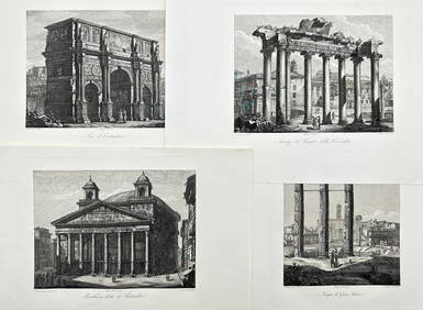
Domenico Amici - Set of 4 prints - Tempio di Giove Statore - Arco di Costantino in Rome, ItalyProverde Auctions4.3(3)See Sold PriceFeb 28, 2024
Antique Pennsylvania Map Fragment incl Wellersburg and New CentervilleCordier Auctions & Appraisals4.4(1.5k)See Sold PriceMar 02, 2024
4 Presidential Prints incl Lincoln PortaritCordier Auctions & Appraisals4.4(1.5k)See Sold PriceMar 02, 2024


![4 Maps incl: AFR: III TAB: [1578 or later]. (1 of 4)](https://p1.liveauctioneers.com/179/85723/44107974_1_x.jpg?height=282&quality=70&version=1456876561)


![[MUSIC]. A group of 4 musical publications, incl. The Lover's Forget-Me-Not, and Songs of (1 of 9)](https://p1.liveauctioneers.com/197/319238/171467978_1_x.jpg?height=282&quality=70&version=1707520367)