MAP - PIETER SCHENK / VALK / JANSSEN Hand Colored superb Map Central Italy c1702Luis Porretta Fine Arts4.3(10)See Sold PriceMar 02, 2024
CHARLES ROLLIN c1828 Ceasar Hand Colored Africa Military MapLuis Porretta Fine Arts4.3(10)See Sold PriceMar 02, 2024
MAP - Dufour, A. H. ( Malte / Brun ) :MAP - ESPAGNE PARTIE SUD DIVISEE EN PROVINCES ANCIENNES ( MAPLuis Porretta Fine Arts4.3(10)See Sold PriceMar 02, 2024
RIGOBERT BONNE c1787 Original Colored Map Germany & Region 15" x 12"Luis Porretta Fine Arts4.3(10)See Sold PriceMar 02, 2024
AMBROISE TARDIEU c1822 Napoleonic War Map GermanyLuis Porretta Fine Arts4.3(10)See Sold PriceMar 02, 2024
MAP - AMBROISE TARDIEU c1822 Napoleonic Miltary Map GermanyLuis Porretta Fine Arts4.3(10)See Sold PriceMar 02, 2024
1822 Rare Map by Ambroise Tardieu Napoleon Caldiero Battle of Vento 17" x 11Luis Porretta Fine Arts4.3(10)See Sold PriceMar 02, 2024
PIETER SCHENK / VALK / JANSSEN Hand Colored Map of Rhodes Greece ca1702 vgcLuis Porretta Fine Arts4.3(10)See Sold PriceMar 02, 2024
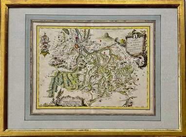
Map: Carte du Canton de Bale, Jacques Clermont, Paris, 1788Kensington Estate Auction4.6(219)See Sold PriceFeb 26, 2024
SoldMallet: Antique Map of France in Regions, 1683TITLE OF THE MAP: 'France' DATE PRINTED: 1683 IMAGE SIZE: Approx Overall page size 13 x 21cm approximately (5 x 8 inches); image size 10.5 x 14.5cm approximately (4 x 5.5 inches) TYPE: Original 17th cSee Sold Price
SoldMallet: Antique Map of France in Regions, 1683Title of the Map: 'France' MAP OF FRANCE. in regions. old antique vintage plan chart Date Printed: 1683 Image Size: Approx Overall page size 13 x 21cm approximately (5 x 8 inches); image size 10.5 x 1See Sold Price
Mallet: Antique Map 'France en General', 1683Title of the Map: 'France en General' Regions Provinces Gouvernements Date Printed: 1683 Image Size: Approx Overall page size 13 x 21cm approximately (5 x 8 inches); image size 10.5 x 14.5cm approximaSee Sold Price
MAP OF FRANCE. in regions. MALLET 1683 old antique vintage plan chartTITLE OF THE MAP: 'France' (Du Globe Terrestre) DATE PRINTED: 1683 IMAGE SIZE: Approx Overall page size 13 x 21cm approximately (5 x 8 inches); image size 10.5 x 14.5cm approximately (4 x 5.5 inches)See Sold Price
SoldMallet: Antique Map of France, 1683Title of the Map: 'France par Gouvernmens Generaux' Date Printed: 1683 Image Size: Approx Overall page size 13 x 21cm approximately (5 x 8 inches); image size 10.5 x 14.5cm approximately (4 x 5.5 inchSee Sold Price
SoldMallet: Antique Map of the World; France, 1683Map Title: 'Planisphere du Monde; France' FRANCE/WORLD. odd-shaped Australia close to southern continent. Date Printed: 1683 Image Size: Approx Overall page size 13 x 21cm approximately (5 x 8 inches)See Sold Price
Mallet: Antique Map of Benelux & Northeast France, 1683TITLE OF THE MAP: 'Cercle de Bourgogne' Includes Luxembourg. Belgium. Parts of France and Germany. DATE PRINTED: 1683 IMAGE SIZE: Approx Overall page size 13 x 21cm approximately (5 x 8 inches); imageSee Sold Price
Mallet: Antique Map of Benelux & Northeast France, 1683Title of the Map: 'Cercle de Bourgogne'. BENELUX & NE FRANCE. Burgundy. Comté. Includes Luxembourg. Belgium. Parts of France and Germany. Date Printed: 1683 Image Size: Approx Overall page size 13 xSee Sold Price
SoldMallet: Antique Map of Iberia, Spain & Portugal, 1683Title of the Map: 'Espagne Moderne' IBERIA. Spain & Portugal showing regions. Date Printed: 1683 Image Size: Approx Overall page size 13 x 21cm approximately (5 x 8 inches); image size 10.5 x 14.5cm aSee Sold Price
Mallet: Antique Map of Spain & Portugal, 1683Title/Content of the Map: IBERIA. 'Espagne Moderne'. Spain & Portugal. Regions & towns Date Printed: 1683 Image Size: Approx Overall page size 26 x 21cm approximately (10 x 8 inches); image size 21 xSee Sold Price
SoldMallet: Antique Map of Kingdom of Burgundy, 1683Title/Content of Map: 'Royaume de Bourgogne sous la seconde race des Roys de France' 2ND KINGDOM OF BURGUNDY, France CH Italy Date Printed: 1683 Image Size: Approx Overall page size 13 x 21cm approximSee Sold Price
SoldMallet: Antique Map of 2nd Kingdom of Burgundy, 1683Title/Content of Map: 'Royaume de Bourgogne sous la seconde race des Roys de France' 2ND KINGDOM OF BURGUNDY. Date Printed: 1683 Image Size: Approx Overall page size 13 x 21cm approximately (5 x 8 incSee Sold Price
FRANCE. Regions Provinces Gouvernements'France en General'. MALLET 1683 mapTITLE OF THE MAP: 'France en General' (De L'Europe) DATE PRINTED: 1683 IMAGE SIZE: Approx Overall page size 13 x 21cm approximately (5 x 8 inches); image size 10.5 x 14.5cm approximately (4 x 5.5 inchSee Sold Price
SoldMallet: Antique Map of the World/France, 1683Title/Content of Map: 'Planisphere du Monde; France' FRANCE/WORLD. odd-shaped Australia close to southern continent. Date Printed: 1683 Image Size: Approx Overall page size 13 x 21cm approximately (5See Sold Price
SoldMallet: Antique View of Paris, France 1683TITLE OF THE PRINT: 'Paris' Decorative view of the city of Paris. DATE PRINTED: 1683 IMAGE SIZE: Approx Overall page size 13 x 21cm approximately (5 x 8 inches); image size 10.5 x 14.5cm approximatelySee Sold Price
Mallet: Antique Map Of North & Cental Ancient Asia 1683TITLE OF THE MAP: 'Partie Septentrionale de L'Ancienne Asie; Scythie de la la M. Imaus; Region Serique; Sarmatie Asiatique; Scythie deca le M.Imaus' Scythia (Ancient Greek: ; Modern Greek: Skythía) wSee Sold Price
Mallet: Antique Map of North & Cental Ancient Asia 1683Partie Septentrionale de L'Ancienne Asie; Scythie de la la M. Imaus; Region Serique; Sarmatie Asiatique; Scythie deca le M.Imaus' Scythia (Ancient Greek: ; Modern Greek: Skythía) was a multinationalSee Sold Price
Mallet: Antique Map of Arctic Continent, 1683Title/Content of Map: 'Continent Septentrional' North Polar region. Iceland, Greenland, Spitzbergen & Novaya Zembla are marked. Date Printed: 1683 Image Size: Approx Overall page size 13 x 21cm approxSee Sold Price
LARGE ANTIQUE MAP FRANCE CENTRAL REGIONAntique France Map on white fabric. Map is divided in two pieces of 17 X 25.5 Inches each. Printed Circa 1907. Unframed.See Sold Price
LARGE ANTIQUE MAP FRANCE CENTRAL REGIONAntique France Map on white fabric. Map is divided in two pieces of 17 X 25.5 Inches each. Printed Circa 1907. Unframed.See Sold Price
LARGE ANTIQUE MAP FRANCE CENTRAL REGIONAntique France Map on white fabric. Map is divided in two pieces of 17 X 25.5 Inches each. Printed Circa 1907. Unframed.See Sold Price
LARGE ANTIQUE MAP FRANCE CENTRAL REGIONAntique France Map on white fabric. Map is divided in two pieces of 17 X 25.5 Inches each. Printed Circa 1907. Unframed.See Sold Price
Mallet: Antique Map of Japan, 1683Title of the Map: 'Isles du Iapon' JAPAN. 'Isles du Iapon'. Yedo (Tokyo) Miyako (Kyoto) Date Printed: 1683 Image Size: Approx Overall page size 13 x 21cm approximately (5 x 8 inches); image size 10.5See Sold Price
SoldMallet: Antique Map of England, 1683Title of the Map: 'Royaume d'Angleterre' ENGLAND counties towns rivers. Date Printed: 1683 Image Size: Approx Overall page size 13 x 21cm approximately (5 x 8 inches); image size 10.5 x 14.5cm approxiSee Sold Price
WEST AFRICA Niger/Gambia rivers tribes towns. 'Pays des Negres'. MALLET 1683 mapJasper524.5(9.8k)See Sold PriceFeb 28, 2024
NORTH & WEST AFRICA. Sahara Niger river 'Zaara ou le Desert'. MALLET 1683 mapJasper524.5(9.8k)See Sold PriceFeb 28, 2024
WEST AFRICA. People of Guinea. 'Peuples de Guinée'. Costume. MALLET 1683 printJasper524.5(9.8k)See Sold PriceFeb 28, 2024
WEST AFRICA. Guinea. Nigeria Ghana Benin Togo Sierra Leone. MALLET 1683 mapJasper524.5(9.8k)See Sold PriceFeb 28, 2024
WEST CENTRAL AFRICA. Congo Angola Gabon Cameroon Sao Tome. MALLET 1683 old mapJasper524.5(9.8k)See Sold PriceFeb 28, 2024
NORTH AFRICA. 'Biledulgerid', a former North African country. MALLET 1683 mapJasper524.5(9.8k)See Sold PriceFeb 28, 2024
WEST AFRICA/MAGHREB Tribes Garamantes Getgulie 'Ancienne Libye'. MALLET 1683 mapJasper524.5(9.8k)See Sold PriceFeb 28, 2024
MALLET. Description de l'Univers. Africa. Volume 3 title page. MALLET 1683Jasper524.5(9.8k)See Sold PriceFeb 28, 2024
NORTH AFRICA. Barbary. Morocco Tunisia Libya Egypt. 'Barbarie'. MALLET 1683 mapJasper524.5(9.8k)See Sold PriceFeb 28, 2024
NORTH AFRICA. Morocco Tunisia Libya. 'Mauritanie'. Malta Melita. MALLET 1683 mapJasper524.5(9.8k)See Sold PriceFeb 28, 2024
NUBIA. 'Nubie'. Nile Valley. Sudan Ethiopia Egypt. MALLET 1683 old antique mapJasper524.5(9.8k)See Sold PriceFeb 28, 2024
SUB-SAHARAN AFRICA. 'Ancienne Ethiopie'. Ancient Ethiopia. MALLET 1683 old mapJasper524.5(9.8k)See Sold PriceFeb 28, 2024
SOUTHERN AFRICA Monomotapa (Mutapa Kingdom) Cafrerie (Kaffraria) MALLET 1683 mapJasper524.5(9.8k)See Sold PriceFeb 28, 2024