ATLAS of ANTIENT GEOGRAPHY by SAMUEL BUTLER 1843John McInnis Auctioneers,LLC4.5(505)See Sold PriceFeb 24, 2024
18TH C. ANTIQUE MAP: FRENCH & INDIAN WAR, FRAMEDThomaston Place Auction Galleries4.4(393)See Sold PriceFeb 24, 2024
Rand McNally Railroad Map Cabinet w/ 21 Railroad MapsRail & Road Auctions4.6(165)See Sold PriceMar 08, 2024
Keith Haring - Ink on New York Map, Best Buddies, Inscribed, Signed, and DatedSapphire Auction Gallery4.1(67)See Sold PriceMar 02, 2024
LATE 17TH C. FRENCH MAP OF THE NEW WORLD BY ALEXIS-HUBERT JAILLOT (1632-1712)Thomaston Place Auction Galleries4.4(393)See Sold PriceFeb 24, 2024
Central Railroad of New Jersey Map of Sandy Hook Route-ca. 1903JM Hobby Supply and Railroad Artifact Auctions4.4(127)See Sold PriceFeb 24, 2024
Lot of Six Mixed Atlas Box Cars-HO Scale-New in BoxJM Hobby Supply and Railroad Artifact Auctions4.4(127)See Sold PriceFeb 25, 2024
Rand McNally/Santa Fe Railroad Map of Iowa-1912JM Hobby Supply and Railroad Artifact Auctions4.4(127)See Sold PriceFeb 24, 2024
NICOLAES VISSCHER (NETHERLANDS, 1618-1709) MAP OF THE NEW WORLDThomaston Place Auction Galleries4.4(393)See Sold PriceFeb 24, 2024
17TH C. WORLD MAP BY NICOLAES VISSCHER (NETHERLANDS, 1618-1709)Thomaston Place Auction Galleries4.4(393)See Sold PriceFeb 24, 2024
Lot of Six Mixed Atlas Cabooses-HO Scale-New in BoxJM Hobby Supply and Railroad Artifact Auctions4.4(127)See Sold PriceFeb 25, 2024
Map (from Textbook) of The Pacific Region of U.S.This map is from the Pacific region taken from a textbook of the time. (Exact year is unknown). Note there is no Nevada on this map. Utah is contiguous to California. 7.5" x 9.75". Map is matted & isSee Sold Price
Sold1869 Richardson Map of the Western US -- Map 1869 ofTitle/Content of Map: 1869 Richardson Map of the Western US -- Map 1869 of the Region Between the Mississippi and the Pacific, to Accompany Richardson's "Beyond the Mississippi". Date: 1869, HartfordCSee Sold Price
1869 Richardson Map of the Western US -- Map 1869 ofTitle/Content of Map: 1869 Richardson Map of the Western US -- Map 1869 of the Region Between the Mississippi and the Pacific, to Accompany Richardson's "Bwyond the Mississippi". Date: 1869, HartfordSee Sold Price
1869 Richardson Map of the Western US -- Map 1869 ofTitle/Content of Map: 1869 Richardson Map of the Western US -- Map 1869 of the Region Between the Mississippi and the Pacific, to Accompany Richardson's "Bwyond the Mississippi". Date: 1869, HartfordSee Sold Price
Map of Oregon & California with gold regionTitle: Oregon and California Author: Swanston, George H. Description: Engraved map, hand-colored in outline. 23.3x14 cm. (9¼x5½"), matted.The U.S. from the Rocky Mountains west to the Pacific Ocean,See Sold Price
Sold3 US Maps[United States]. 3 Maps. ++ Isothermal Chart: Of The Region North of the 36th Parallel &c. &c. between the Atlantic & Pacific Ocean. Compiled by Isaac I. Stevens, Governor of Washington Territory. MapSee Sold Price
SoldMAPS, Pacific Ocean, U.S. NavyPacific Ocean. U.S. Navy/Andriveau-Goujon, [Lot of 2] Naval Chart of the Pacific and Western Atlantic [and] Oceanie, 1860-1901 (circa). This lot contains two maps focused on colonial ownership in theSee Sold Price
SoldMaris Pacifici , 19th C map of the Pacific region ,Maris Pacifici , 19th C map of the Pacific region , after Ortelius Abrahamus. PROVENANCE: Francis de Sales McHugh Collection. 13 x 19in. (33 x 48cm)See Sold Price
U.S. Pacific Rail Road Geologic Map, 1859Map: U.S. Pacific Rail Road Exp. & Surveys. War Department. Geologic Map Maker: War Department, Whipple, Amiel Weeks/William P. Blake/Jules Marcou Publisher: War Department, 1859 Washington DC Size: OSee Sold Price
SoldUS NAVY PACIFIC OCEAN MAP OF APRIL 1939US NAVY PACIFIC OCEAN MAP OF APRIL 1939 From Rear Admiral George B.H. Stallings Archive; US Navy, Pacific Ocean April 1939 map. Rear Admiral George B.H. Stallings served in the Navy Department’s BurSee Sold Price
1882 Map of the US Pacific StatesTitle: 1882 Map of the US Pacific States Author: Blackie Medium: Ink on Paper Dimensions: 11"X15" Description: Map of the US Pacific Coast states dated 1882. Part of the Comprehensive Atlas & GeographSee Sold Price
1853 US Pacific Railroad Survey Transcontinental RRare 1853 US Pacific Railroad survey map. Printed by the U.S. Pacific Rail Road Explorations & Surveys, War Department. This is a famous government survey to discover a route for a much needed transcoSee Sold Price
Pacific Railroad Survey Transcontinental Route RRRare 1853 US Pacific Railroad survey map. Printed by the U.S. Pacific Rail Road Explorations & Surveys, War Department. This is a famous government survey to discover a route for a much needed transcoSee Sold Price
Pacific Railroad Survey Transcontinental Route RRRare 1853 US Pacific Railroad survey map. Printed by the U.S. Pacific Rail Road Explorations & Surveys, War Department. This is a famous government survey to discover a route for a much needed transcoSee Sold Price
Pacific Railroad Survey Transcontinental Route RRRare 1853 US Pacific Railroad survey map. Printed by the U.S. Pacific Rail Road Explorations & Surveys, War Department. This is a famous government survey to discover a route for a much needed transcoSee Sold Price
SoldLarge railroad survey of SouthwestHeading: (Southwest) Author: U.S. Pacific Railroad Survey Title: Map No.1. Reconnaissance and Survey of a Railway Route from Mississippi River near 35th Parallel North Lat. to Pacific Ocean Made underSee Sold Price
Sold(HAWAII) A group of three maps of Hawaii, 1878.(HAWAII) A group of three maps of Hawaii and the Pacific region. Kauai. Government Survey. 1878. Washington: The Morris Peters Co., n.d. The Pacific Ocean, including Oceana. Thomas Cowperthwait,See Sold Price
SoldCary: US Western Territory/Great Lakes Region Map, 1805Map: A New Map of Part of the United States of North America, exhibiting the Western Territory, Kentucky, Pennsylvania, Maryland, Virginia &c., also the lakes Superior, Michigan, Huron, Ontario & ErieSee Sold Price
SoldC.J. Collins Union Pacific Railroad Map of USMeasuring approx. 42" high x 63" wide with wood across the top and bottom edges. Printed by C.J.Collins March 1950 with Rand McNally Co. Map includes the Union Pacific Railroad routes, plus steamshipSee Sold Price
Sold2 Levasseur maps, Western U.S. and Pacific, 19th cTwo Victor Levasseur maps. Item 1: Steel engraved map of the world with colored borders titled "Planisphere" map by Victor Levasseur, engraved by Raimond Bonheur. Surrounded by an elaborate border witSee Sold Price
Large geologic map of YellowstoneTitle: Yellowstone National Park and North Western Wyoming Author: U.S. Geological Survey Description: Color lithographed map. 89.5x66 cm. (35¼x26").Large map of the Yellowstone region from the U.S.See Sold Price
Sold"Camel" Map of Southwest 1858Heading: (Southwest) Author: U.S. Pacific Railroad Survey Title: Preliminary Map of the Western Portion of the Reconnaissance and Survey for the Pacific Rail Road Route near the 35th Parallel... withSee Sold Price
SoldMap of the North Polar Region 1879Title: Map of the North Polar Region Author: U.S. Hydrographic Office Description: Color lithographed map, sectioned for folding and backed with linen, as issued. 61.8x79.8 cm. (24¼x31½").Polar mapSee Sold Price
SoldMitchell's School AtlasWith 14 hand-colored copper-engraved maps (4 are double-page), plus insets. 11¾x9½, original quarter green morocco and pictorial boards. Double-page maps all of various U.S. regions, including the eSee Sold Price
Lake Superior and Mississippi River RR 1869 Seven Percent Bonds Book/Report-1869JM Hobby Supply and Railroad Artifact Auctions4.4(127)See Sold PriceFeb 24, 2024
Rock Island RR Iowa and Minnesota Lakes Country Brochure-1926JM Hobby Supply and Railroad Artifact Auctions4.4(127)See Sold PriceFeb 24, 2024
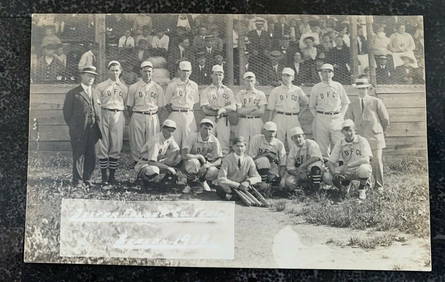
1912 Mint RPPC Postcard Dexter Folder Co. Baseball Team on FieldMynt Auctions4.6(697)See Sold PriceFeb 24, 2024
Hermes Sterling Silver 18k Yellow Gold Large H Band RingPacific Global Auction3.9(280)See Sold PriceFeb 27, 2024
Van Cleef & Arpels Toujours Platinum 4mm Wide Band Ring Size 51Pacific Global Auction3.9(280)See Sold PriceFeb 24, 2024
Hermes 18k Rose Gold Collier De Chien Lock Band Ring Size 49 US 4 3/4Pacific Global Auction3.9(280)See Sold PriceFeb 26, 2024
Authentic! Cartier Trinity 18k Tri-Color Gold Band RingPacific Global Auction3.9(280)See Sold PriceFeb 26, 2024
Elgin B. W. Raymond mens Watch In 14KT Yellow GoldPacific Global Auction3.9(280)See Sold PriceFeb 25, 2024