Soldmaps of various states within the USAHeading: (United States) Author: Title: Sixteen maps of cities, states and counties of the United States of America Place Published: Publisher: Date Published: Mostly mid to late 19th centuSee Sold Price
maps of various states within the USATitle: Sixteen maps of cities, states and counties of the United States of America Author: ** Description: Including: 7 maps from Asher & Adams' publication, all but one are double-paged. Plus table oSee Sold Price
maps of various states within the USAHeading: (United States) Author: Title: Sixteen maps of cities, states and counties of the United States of America Place Published: Publisher: Date Published: Mostly mid to late 19th centuSee Sold Price
Maps Various States (116944)Map of Nevada, New York, New Jersey, Ohio, Indiana, Iowa, Missouri, Maryland, Baltimore, Pennsylvania (5)Date: Country if not USA: State: City: Provenance: Ken Prag CollectionSee Sold Price
SoldMaps Various States (116944)Map of Nevada, New York, New Jersey, Ohio, Indiana, Iowa, Missouri, Maryland, Baltimore, Pennsylvania (5)Date: Country (if not USA): State: City: Provenance: Ken Prag CollectionATTENTION CHRISTMAS SHOSee Sold Price
Maps Various States (116944)Map of Nevada, New York, New Jersey, Ohio, Indiana, Iowa, Missouri, Maryland, Baltimore, Pennsylvania (5) Provenance: Ken Prag Collection Country (if not USA): State: City/County: Date:See Sold Price
SoldArizona 1:125,000 Series Topo Maps (old), c 1895-1910Six of the old 1:125,000 series maps, various conditions. Verde, Clifton, Winkleman, Roosevelt, Tucson, Fresnal Provenance: Country (if not USA): State: Arizona City/County: Date:See Sold Price
SoldReport of the General Land Office, 1860with ten fold out maps of the states including California 9" x 5 1/2" SHIPPING: Shipping available within the Continental USA (excludes insurance) $30. International buyers are responsible for arrangiSee Sold Price
SoldRailroad Map and Ephemera Collection [133487]Four RR maps circa 1940-50; various RR-related ephemera including RR trade cards, RR fare guides, RR magazines, and reproduction Santa Fe signDate: Country (if not USA): State: City: Provenance: GarySee Sold Price
SoldMap of the United States TerritoriesForest Thayer & Co, New York 1853 36" x 35" estimate 300/500 $45 Shipping available within the Continental USA . This amount excludes insurance which will be calculated based upon the selling price. ASee Sold Price
SoldWhite Mountains, New Hampshire and General USAWhite Mountains, New Hampshire and General USA Stereoview Card Assortment Including (54) views of the White Mountains and (125) views of various locations within the United States Height: 3.50 inches,See Sold Price
Travel Poster Arizona Vacation State USAOriginal vintage travel poster for Arizona Vacation State of the Nation featuring an illustrated map of Arizona marking routes and towns and showing various sports and activities including horse ridinSee Sold Price
Sold25-19th century maps of the United StatesTitle: Lot of various 19th century maps of North America or the United States Author: ** Description: Includes approximately 20 maps of various sizes and of different regions within the North America.See Sold Price
Map of USA, former property of Dick ClarkMap of USA, former property of Dick Clark. Autographed map of USA, autographed by various famous music artists on their home states. Madonna, Billy Preston, Ben E. King, Beach Boys, Joe Walsh, Carl PeSee Sold Price
SoldUSA 1911 Lot of 8 State Maps. Encyclopaedia BritannicaIncl Tennesse, Georgia, Iowa, Michigan, Missouri, Illinois, Idaho/Montana and Indiana. Lithograph Maps Published 1911, New York for "The Encyclopaedia Britannica" 11th Edition by Various Contributors.See Sold Price
SoldUSA 1911 Lot of 5 Maps from The Encyclopedia BritannicaNorth America, plus 4 State Maps - Wisconsin, Ohio, New Hampshire/Vermont, and New York. Lithograph Maps Published 1911, New York for "The Encyclopaedia Britannica" 11th Edition by Various ContributorSee Sold Price
SoldLARGE LOT OF MAPS VARIOUS STATES AND COUNTRIESCOMES WITH FLASHLITES CAR CARRYING CASE, PLASTIC AIRPLANE AND AIRPLANE BOOKS COMES WITH DE ICERSee Sold Price
SoldLarge Lot of Mobilgas Maps- Various States40 maps included. Various age and condition. As pictured.See Sold Price
SoldColton/Johnson State Maps [Various State Maps]Four Colton Maps - Illinois, Indiana, Iowa and New Hampshire. J. H. Colton Cartographer. Published by J. H. Colton, New York. Stamped 'Entered according to Act of Congress in the Year 1855 by J. H. CoSee Sold Price
SoldBiagioli Gubbio Italian Pottery CoveredBiagioli Gubbio Italian Pottery Covered Apothecary Medical Signed Jar 9 Inch Savra in great condition. Shipping cost for this item within the lower 48 states within USA is $30See Sold Price
SoldGroup of 15 Vintage Road Maps with Various StatesFeaturing Shell, Sinclair, Phillips 66, Standard, and TexacoSee Sold Price
SoldMetal Esso Touring Service brochure holderMetal Esso Touring Service brochure holder 23 1/2 in tall 13 1/2 in wide. Comes with approximately 30 Esso traveling maps of various States. Has some wear, but overall decent condition.See Sold Price
SoldCOLLECTION OF 47 MAPSCOLLECTION OF 47 MAPS: Comprising; 11- 2-piece seamed maps from a book, having articles about numerous countries, at the verso. 18- pages from a book, having 36- maps of various states. Largest ApproxSee Sold Price
SoldSenate Executive Documents, 33 Survey Vintage MapsSenate Executive Documents, 33 Survey Vintage Maps Circa 1850s Senate Executive map survey documents from the 33rd session of Congress. Highly detailed surveyor maps of various states and locations thSee Sold Price
American Express/New York Central Railroad Map of the United States-1934JM Hobby Supply and Railroad Artifact Auctions4.4(127)See Sold PriceFeb 24, 2024
Union Pacific RR Map of the United States-1926JM Hobby Supply and Railroad Artifact Auctions4.4(127)See Sold PriceFeb 24, 2024
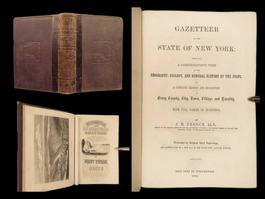
1860 NEW YORK State Gazetteer Geography Americana Colonial USA IllustratedSchilb Antiquarian Rare Books4.8(428)See Sold PriceMar 31, 2024
ANDREW RAYMOND JANSON OIL ON BOARD ADIRONDACKSCharleston Estate Services Ltd.4.5(69)See Sold PriceMar 03, 2024
Mitchell - Map of the City of Washington (Washington, DC)Trillium Antique Prints & Rare Books4.5(32)See Sold PriceFeb 24, 2024
A quantity of World War II / Two military ephemera to include assorted 1940s newspapers pages toClaydon Auctioneers Ltd4.3(125)See Sold PriceFeb 26, 2024
A23 United States in the Caribbean Denoyer-Geppert Social Science MapsJasper524.5(9.9k)See Sold PriceFeb 27, 2024
Carte de la Barbarie… l'empire de Maroc… North Africa Morocco. LAPIE 1829 mapJasper524.5(9.9k)See Sold PriceFeb 28, 2024
Carte d'Afrique. Africa Soudan Zanzibar. LAPIE 1831 old antique map plan chartJasper524.5(9.9k)See Sold PriceFeb 28, 2024
Carte de l'Afrique propre, de la Numidie… North Africa. LAPIE 1829 old mapJasper524.5(9.9k)See Sold PriceFeb 28, 2024
Blackie (Pub) 1882 Folio Map. West USA - Pacific StatesAlbion Auctions4.7(341)See Sold PriceMar 01, 2024
Map of United States of North America, 1785Antiques Online Auctions4.6(415)See Sold PriceMar 14, 2024


![Railroad Map and Ephemera Collection [133487] (1 of 1)](https://p1.liveauctioneers.com/2699/193399/97512484_1_x.jpg?height=282&quality=70&version=1612301936)


![Colton/Johnson State Maps [Various State Maps] (1 of 14)](https://p1.liveauctioneers.com/5755/157962/79722067_1_x.jpg?height=282&quality=70&version=1576875253)