ATLAS of ANTIENT GEOGRAPHY by SAMUEL BUTLER 1843John McInnis Auctioneers,LLC4.6(502)See Sold PriceFeb 24, 2024
18TH C. ANTIQUE MAP: FRENCH & INDIAN WAR, FRAMEDThomaston Place Auction Galleries4.4(386)See Sold PriceFeb 24, 2024
Rand McNally Railroad Map Cabinet w/ 21 Railroad MapsRail & Road Auctions4.6(165)See Sold PriceMar 08, 2024
Keith Haring - Ink on New York Map, Best Buddies, Inscribed, Signed, and DatedSapphire Auction Gallery4(67)See Sold PriceMar 02, 2024
LATE 17TH C. FRENCH MAP OF THE NEW WORLD BY ALEXIS-HUBERT JAILLOT (1632-1712)Thomaston Place Auction Galleries4.4(386)See Sold PriceFeb 24, 2024
Central Railroad of New Jersey Map of Sandy Hook Route-ca. 1903JM Hobby Supply and Railroad Artifact Auctions4.4(126)See Sold PriceFeb 24, 2024
Lot of Six Mixed Atlas Box Cars-HO Scale-New in BoxJM Hobby Supply and Railroad Artifact Auctions4.4(126)See Sold PriceFeb 25, 2024
Rand McNally/Santa Fe Railroad Map of Iowa-1912JM Hobby Supply and Railroad Artifact Auctions4.4(126)See Sold PriceFeb 24, 2024
NICOLAES VISSCHER (NETHERLANDS, 1618-1709) MAP OF THE NEW WORLDThomaston Place Auction Galleries4.4(386)See Sold PriceFeb 24, 2024
17TH C. WORLD MAP BY NICOLAES VISSCHER (NETHERLANDS, 1618-1709)Thomaston Place Auction Galleries4.4(386)See Sold PriceFeb 24, 2024
Lot of Six Mixed Atlas Cabooses-HO Scale-New in BoxJM Hobby Supply and Railroad Artifact Auctions4.4(126)See Sold PriceFeb 25, 2024
SoldKY and TN Map, Cyrus Harris, c. 1796Cyrus Harris, A MAP OF THE STATE OF KENTUCKY AND THE TENNESSEE GOVERNMENT COMPILED FROM THE BEST AUTHORITIES from Jedidiah Morse's The American Universal Geography. Boston: Thomas and Andrews, 1796. ESee Sold Price
SoldCyrus Harris KY & TN Map, 1796A Map of the State of Kentucky and the Tennessee Government Compiled from the Best Authorities, by Cyrus Harris, engraved by Amos Doolittle, published by Thomas and Andrews, Boston, 1796. From "The AmSee Sold Price
SoldKentucky and Tennessee Map, 1796 Cyrus HarrisCyrus Harris, "A Map of the State of Kentucky and the Tennessee Government Compiled from the Best Authorities," from Jedidiah Morse's The American Universal Geography. Boston: Thomas and Andrews, 1796See Sold Price
Sold4 19th c. KY & TN Maps1st item: "Kentucky and Tennessee" Map, by Sidney E. Morse and Samuel Breese, published by Harper and Brothers, 1845. Colored cerograph of Kentucky and Tennessee depicting towns, roads, county lines,See Sold Price
Sold6 mid-19th C. Maps incl. TN & KY MapGroup of six (6) mid-19th century maps. 1st item: MAP OF TENNESSEE AND KENTUCKY by G.W. Boynton & Co., showing railroads and canals. 9 3/4" x 12 5/8". 2nd item: MIDDLE STATES map engraved by J. T. HamSee Sold Price
Colton's Kentucky and TennesseeTitle/Content of Map: Colton's Kentucky and Tennessee Date: 1869 Publisher: G.W. and C.B. Colton Size: 16Height - 26.5Width No.58, 59. Double folio Colton KY/TN maps are quite scarce. Reserve: $70.00See Sold Price
SoldColton's Kentucky and TennesseePublication Date: 1869 Title: Colton's Kentucky and Tennessee Cartographer: Publisher: G.W. and C.B. Colton No.58, 59. Double folio Colton KY/TN maps are quite scarce. Dimensions: 16"H. x 26.5"W. ReseSee Sold Price
SoldKentucky and Tennessee Map, 1796 HarrisCyrus Harris, "A Map of the State of Kentucky and the Tennessee Government Compiled from the Best Authorities," from Jedidiah Morse's The American Universal Geography. Boston: Thomas and Andrews, 1796See Sold Price
SoldKentucky and Tennessee Map, 1796 HarrisCyrus Harris, "A Map of the State of Kentucky and the Tennessee Government Compiled from the Best Authorities," from Jedidiah Morse's The American Universal Geography. Boston: Thomas and Andrews, 1796See Sold Price
SoldKentucky and Tennessee Map, 1796 HarrisCyrus Harris, "A Map of the State of Kentucky and the Tennessee Government Compiled from the Best Authorities," from Jedidiah Morse's The American Universal Geography. Boston: Thomas and Andrews, 1796See Sold Price
Map of the State of Kentucky and the TennesseeTitle: Map of the State of Kentucky and the Tennessee Government Publicaiton Date: 1796 Cartographer: HARRIS, CYRUS/A. DOOLITTLE Publisher: THOMAS & ANDREWS Size: 7.6Height - 11.3Width Additional InfoSee Sold Price
SoldKY TN OH IN IL, State Populations 1831 Goodrich MapEarly 19th c. Hand-colored Map, Kentucky Tennessee Ohio Indiana Illinois, State Populations | Published: Boston: S.G. Goodrich, 1831 | Very nice hand colored engraved map showing each state with populSee Sold Price
Sold4 Maps, Incl TN, KY1st item: "Colton's Kentucky and Tennessee" Map, by George W. Colton, published by G. W. Colton and C. B. Colton & Co., New York, 1864. From "Colton's Atlas Of The World" By G. W. Colton. Steel plateSee Sold Price
SoldThree 18th century maps of KentuckyCyrus Harris, [A Map of the State of Kentucky and the Tennessee Government…], Boston, Thomas & Andrews, 1796, Indian and military boundaries delineated, image 7-3/4 x 11-3/8 in., [extensive foxing aSee Sold Price
SoldAmos Doolittle Engraved Map of PennsylvaniaColonial America c. 1795 Amos Doolittle Engraved Map of Pennsylvania c. 1795 Federal Period, Map of Pennsylvania, By Cyrus Harris, Engraved by Amos Doolittle, measuring 13.5” x 8”, Very Fine. An oSee Sold Price
SoldKentucky and Tennessee Map, 1796 Harris"A Map of the State of Kentucky and the Tennessee Government Compiled from the Best Authorities", by Cyrus Harris, engraved by Amos Doolittle, published by Thomas and Andrews, Boston, 1796. From "TheSee Sold Price
SoldKentucky and Tennessee Map, 1796 Harris"A Map of the State of Kentucky and the Tennessee Government Compiled from the Best Authorities", by Cyrus Harris, engraved by Amos Doolittle, published by Thomas and Andrews, Boston, 1796. From "TheSee Sold Price
SoldTHREE 18TH C. TERRITORY ENGRAVINGS, AMOS DOOLITTLEThree 18th C. maps of America comprising Amos Doolittle (American, 1754-1832). Map of Pennsylvania territory - circa 1795, mapped by Cyrus Harris engraved by Amos Doolittle, copperplate engraving on pSee Sold Price
Map of West Indies from the Best AuthoritiesCirca 1796 Antique Map. Title: "Map of West Indies from the best Authorities". Citation: by Cyrus Harris. Amos Doolittle, Sculp. Approximate size: 12-1/4" x 8-1/4". Please note that this lot has a conSee Sold Price
Sold1796 Tennessee Kentucky hand colored map1796 hand-colored map of the State of Kentucky and the Tennessee government, "Thomas & Andrews. Boston. Compiled from the best authorities by Cyrus Harris. Engraved by A. Doolittle." Note - hand colorSee Sold Price
THREE 18TH C. TERRITORY ENGRAVINGS, AMOS DOOLITTLEThree 18th C. maps of America comprising Amos Doolittle (American, 1754-1832). Map of Pennsylvania territory - circa 1795, mapped by Cyrus Harris engraved by Amos Doolittle, copperplate engraving on pSee Sold Price
SoldLot of 7 Antique MapsCirca 1796 Lot of 7 Antique Maps; ??Titles: "England, Scotland, Ireland and Wales from the best Authorities" by Cyrus Harris "Hindostan or India from the best Authorities" (Doolittle, sculp.) "SwitzerSee Sold Price
Sold3 19th cent. AL, KY, & TN Maps1st item: "Map of the States of Kentucky, and Tennessee" by John H. Hinton, engraved and printed by Fenner Sears and Company, published by Issac T. Hinton and Simpkin and Marshall, London, 1832. FromSee Sold Price
Sold3 KY & TN Maps: Vance, Tanner, Johnson1st item: "Map of Kentucky and Tennessee Compiled from the Latest Authorities", drawn by D. H. Vance, engraved by J. H. Young, published by Anthony Finley, Philadelphia, 1826. From "A New American AtlSee Sold Price
17TH C. WORLD MAP BY NICOLAES VISSCHER (NETHERLANDS, 1618-1709)Thomaston Place Auction Galleries4.4(386)See Sold PriceFeb 24, 2024
LATE 17TH C. FRENCH MAP OF THE NEW WORLD BY ALEXIS-HUBERT JAILLOT (1632-1712)Thomaston Place Auction Galleries4.4(386)See Sold PriceFeb 24, 2024
17TH C. ANTIQUE MAP SIEGE OF LA ROCHELLE, FRANCE, FRAMEDThomaston Place Auction Galleries4.4(386)See Sold PriceFeb 24, 2024
EARLY 18TH C. MAP OF ITALY, FRAMEDThomaston Place Auction Galleries4.4(386)See Sold PriceFeb 24, 2024
LATE 16TH C. MAP OF SCOTLAND BY MERCATOR, FRAMEDThomaston Place Auction Galleries4.4(386)See Sold PriceFeb 24, 2024
17TH C. MAP OF THE BERKSHIRES BY JOHN SPEED, FRAMEDThomaston Place Auction Galleries4.4(386)See Sold PriceFeb 24, 2024
18TH C. ANTIQUE MAP: FRENCH & INDIAN WAR, FRAMEDThomaston Place Auction Galleries4.4(386)See Sold PriceFeb 24, 2024
17TH C. ENGLISH LINEAR MAP BY OGILBY, FRAMEDThomaston Place Auction Galleries4.4(386)See Sold PriceFeb 24, 2024
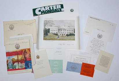
1977 INAUGURATION of PRESIDENT JIMMY CARTERJohn McInnis Auctioneers,LLC4.6(502)See Sold PriceFeb 25, 2024
ROOSEVELT, Franklin Delano (1882-1945) and CHURCHILL, Sir W...Potter & Potter Auctions4.6(539)See Sold PriceMar 07, 2024
Johann Homann Hand-Colored Map Engraving, c. 1730Auctions at Showplace4.5(726)See Sold PriceMar 17, 2024
Willem Blaeu, Etc. 17th C. Antiquarian Maps, 2Auctions at Showplace4.5(726)See Sold PriceMar 17, 2024
3 3/16" Thebes. Warren Co, KY. Recovered by C. Miller. PicturedTony Putty Artifacts4.7(404)See Sold PriceMar 09, 2024
Two (2) Antique 18th C. Copper Engraved Framed Maps - America & EuropeMagnusson Art Group4.5(46)See Sold PriceMar 14, 2024
Carey, pub. 1796 - Map of GeorgiaTrillium Antique Prints & Rare Books4.5(30)See Sold PriceFeb 24, 2024
Carey, pub. 1796 - Map of The State of South CarolinaTrillium Antique Prints & Rare Books4.5(30)See Sold PriceFeb 24, 2024
Carey, pub. 1796 - Map of KentuckyTrillium Antique Prints & Rare Books4.5(30)See Sold PriceFeb 24, 2024
Carey, pub. 1796 - Map of the Tennassee State formerly part of North Carolina (Tennessee)Trillium Antique Prints & Rare Books4.5(30)See Sold PriceFeb 24, 2024
Solomon Hougham English Georgian Sterling Silver Tea Pot w/ Wood c.1796Mynt Auctions4.6(680)See Sold PriceMar 01, 2024