ATLAS of ANTIENT GEOGRAPHY by SAMUEL BUTLER 1843John McInnis Auctioneers,LLC4.6(502)See Sold PriceFeb 24, 2024
18TH C. ANTIQUE MAP: FRENCH & INDIAN WAR, FRAMEDThomaston Place Auction Galleries4.4(386)See Sold PriceFeb 24, 2024
Rand McNally Railroad Map Cabinet w/ 21 Railroad MapsRail & Road Auctions4.6(165)See Sold PriceMar 08, 2024
Keith Haring - Ink on New York Map, Best Buddies, Inscribed, Signed, and DatedSapphire Auction Gallery4(67)See Sold PriceMar 02, 2024
LATE 17TH C. FRENCH MAP OF THE NEW WORLD BY ALEXIS-HUBERT JAILLOT (1632-1712)Thomaston Place Auction Galleries4.4(386)See Sold PriceFeb 24, 2024
Central Railroad of New Jersey Map of Sandy Hook Route-ca. 1903JM Hobby Supply and Railroad Artifact Auctions4.4(126)See Sold PriceFeb 24, 2024
Lot of Six Mixed Atlas Box Cars-HO Scale-New in BoxJM Hobby Supply and Railroad Artifact Auctions4.4(126)See Sold PriceFeb 25, 2024
Rand McNally/Santa Fe Railroad Map of Iowa-1912JM Hobby Supply and Railroad Artifact Auctions4.4(126)See Sold PriceFeb 24, 2024
NICOLAES VISSCHER (NETHERLANDS, 1618-1709) MAP OF THE NEW WORLDThomaston Place Auction Galleries4.4(386)See Sold PriceFeb 24, 2024
17TH C. WORLD MAP BY NICOLAES VISSCHER (NETHERLANDS, 1618-1709)Thomaston Place Auction Galleries4.4(386)See Sold PriceFeb 24, 2024
Lot of Six Mixed Atlas Cabooses-HO Scale-New in BoxJM Hobby Supply and Railroad Artifact Auctions4.4(126)See Sold PriceFeb 25, 2024
Gibson/Sayer: Antique Map of Western Hemisphere, 1786Map: A New Map of the Whole Continent of America Divided into North and South and West Indies wherein are exactly Described the United States of North America Cartographer: J. Gibson / R. Sayer PlaceSee Sold Price
Gibson / Sayer: Antique Map of Western Hemisphere, 1786Map: A New Map of the Whole Continent of America Divided into North and South and West Indies wherein are exactly Described the United States of North America Cartographer: J. Gibson / R. Sayer PlaceSee Sold Price
de l'Isle/Dezauche: Antique Map Western Hemisphere 1782Hemisphere Occidental Dresse pour l'usage particulier du Roi. De l'Isle's important Americas map updated by Dezauche to take into account the discoveries and voyages of Captain Cook. The map shows CooSee Sold Price
Steiler/Perthes: Antique Map Western Hemisphere, 1852Westliche Halbkugel. A dramatic hemispherical projection of the Americas and eastern Polynesia, from Steiler's Handatlas, with good topographical detail throughout. Greenland's status as an island isSee Sold Price
Seutter: Antique Map of Western Hemisphere, 1740Title/Content of Map: Western Hemisphere with California as an Island by Seutter Date Printed: c1740 Cartographer: Matthaus Seutter Material/Medium: Paper Size: 24" x 19 1/2" Original hand colored CopSee Sold Price
Aspin: Antique Map of Western Hemisphere, 1832Title: North & South America; for the Elucidation of the Abbe Gaultier's Geographical Games. Aspin western hemisphere with proposed state of Franklinia and unusual boundaries Map maker: Jehoshaphat AsSee Sold Price
Lapie: Antique Map of Western Hemisphere, 1819Map: Amerique Septentrionale et Meridionale Dediee et Presentee au Roi Cartographer: P. Lapie Place & Date: Paris / 1819 Size: 29" x 20" Condition: outline color; light overall age toning; repaired spSee Sold Price
SoldVaugondy: Antique Map of Western Hemisphere, 1750sTitle/Content of Map: 1750's Western Hemisphere Date Printed: 1750's Cartographer: Robert de Vaugondy Material/Medium: Paper Size: 6" x 8" Hand colored copperplate engraved. Published in Paris. GillesSee Sold Price
Moll: Antique Map of Western Hemisphere, 1746Title/Content of Map: Western Hemisphere with California as an Island by Moll Date Printed: 1746 Cartographer: Thomas Salmom & Herman Moll Material/Medium: Paper Size: 14 1/2" x 8 1/2" Copperplate engSee Sold Price
Lapie: Antique Map of Western Hemisphere & Islands 1819Map: Amerique Septentrionale et Meridionale Dediee et Presentee au Roi Cartographer: P. Lapie Place & Date: Paris / 1819 Size: 29" x 20" Condition: outline color; light overall age toning; repaired spSee Sold Price
Thompson: Antique Map of Western Hemisphere, 1815Map: Western Hemisphere. Publication Date: 1815 Authors: THOMPSON'S NEW GENERAL ATLAS, NEELE, sc. Publisher: THOMPSON'S NEW GENERAL ATLAS Size: Folio – 20.00 W Inches Western hemisphere sheet from aSee Sold Price
de la Tour: Antique Map of Western Hemisphere, 1771Title/Content of Map: 'Hémisphère Occidental' The Western Hemisphere: North and South America. The rumoured "Mer de l'Ouest" (inland Western Sea) within the western part of North America is marked,See Sold Price
SoldColored Antique Map World & Western Hemisphere 1898This colorful map came from Cram's 1898 Universal Atlas - Geographical, Astronomical and Historical. In 1869 the George F. Cram Company was born and the Cram name quickly became synonymous with accuraSee Sold Price
de la Tour: Antique Map of Western Hemisphere, 1771TITLE/CONTENT OF MAP: 'Hémisphère Occidental' The Western Hemisphere: North and South America. The rumoured "Mer de l'Ouest" (inland Western Sea) within the western part of North America is marked,See Sold Price
de la Tour: Antique Map of Western Hemisphere, 1771Hémisphère Occidental' The Western Hemisphere: North and South America. The rumoured "Mer de l'Ouest" (inland Western Sea) within the western part of North America is marked, curiously with the "R[iSee Sold Price
Mentelle / Chanlaire: Antique Map of Western HemisphereTitle/Content of Map: Fine antique map of the Western Hemsisphere. Carte générale et Politique de l Amérique Date Printed: 1798 Cartographer: Mentelle and Chanlaire Size (inches): 16 x 13 OriginalSee Sold Price
SoldColton: Antique Map of Western Hemisphere, 1859Title/Content of Map: Western Hemisphere by Colton Date Printed: 1859 Cartographer: H. J. Colton Material/Medium: Paper Size: 17 1/2" 15" Hand colored engraved. Published in New York in 'Colton's GeneSee Sold Price
Warner Beers: Antique Map of Western Hemisphere, 1878Map: 1878 Warner Beers Western Hemisphere -- Western Hemisphere Date/Place: c. 1878, Chicago Cartographer: Warner Beers Size: 14.5 x 17.5 in. Condition: Very good. Nice color, sharp print. Marginal toSee Sold Price
SDUK: Antique Map of Western Hemisphere, 1845WESTERN HEMISPHERE'. The borders on the map have been drawn to show Texas as being part of Mexico, reflecting the situation prior to the Texas revolution which ended in the Texan declaration of IndepeSee Sold Price
Colored Antique Map World & Western Hemisphere 1898 This colorful map came from Cram's 1898 Universal Atlas - Geographical, Astronomical and Historical. In 1869 the George F. Cram Company was born and the Cram name quickly became synonymous with accuraSee Sold Price
SoldHondius: Antique Map of the Western Hemisphere, 1630Title/Content of Map: Western Hemisphere by H Hondius with sea monsters Date Printed: c1630-1634 Cartographer: Henricus Hondius Material/Medium: Paper Size: Approx 17" x 21" Magnificent Map. PublishedSee Sold Price
SoldHondius: Antique Map of the Western Hemisphere, 1631Title: America noviter delineata. Hondius 1631 western hemisphere with polar inserts Map maker: Henricus Hondius Place and Year: Amsterdam, 1631 Dimensions: 37.7 x 49.8 cm (14¾ x 19½ in) Technique:See Sold Price
Hondius: Antique Map of the Western Hemisphere, 1630Map: Western Hemisphere Date Printed: c 1630-1634 Cartographer: Henricus Hondius Material/Medium: Paper Size: *** Approx 17" x 21" Thick paper. Script on verso. Amsterdam, Dutch edition. Based on HondSee Sold Price
SoldClouet: Antique Map of the Western Hemisphere, 1781Title/Content of Map: Carte D'Amerique Date Printed: 1781 Cartographer: Clouet Material/Medium: Paper Size: 20" x 26" Rare and highly decorative 'Bay of the West' Map of the Western Hemisphere. PublisSee Sold Price
19thc Colton Map, Comparitive Size of Lakes & IslandsConnoisseur Auctions4(333)See Sold PriceFeb 24, 2024
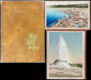
Schmidt's Memoir, A Western Trip - Volume with 12 Photos by William Henry Jackson, 17 by Schmidt andTrillium Antique Prints & Rare Books4.5(30)See Sold PriceFeb 24, 2024
EARLY COLONIAL WEST AFRICA. Empires of Sokoto Gando Mas.Tribes.Fellatah 1882 mapJasper524.5(9.8k)See Sold PriceFeb 28, 2024
NORTH & WEST AFRICA. Gold Coast (Ghana) Slave Coast. Tribal names 1890 mapJasper524.5(9.8k)See Sold PriceFeb 28, 2024
Afrique. Partie du Sahara #12. Mauritania. Western Sahara. VANDERMAELEN 1827 mapJasper524.5(9.8k)See Sold PriceFeb 28, 2024
West coast of Africa from Cape Blanco… Arguin bay, Mauritania. LABAT 1745 mapJasper524.5(9.8k)See Sold PriceFeb 28, 2024
Western Africa by Edward Weller. Early British/French settlements 1860 old mapJasper524.5(9.8k)See Sold PriceFeb 28, 2024
West Africa. Liberia Sahara Senegambia Guinea. Mountains of Kong COLTON 1869 mapJasper524.5(9.8k)See Sold PriceFeb 28, 2024
North west Africa. Liberia inset. Sahara Senegambia Guinea. COLTON 1863 mapJasper524.5(9.8k)See Sold PriceFeb 28, 2024
WESTERN AFRICA.Kong Mountains.Caravan routes.Slave Coast.TALLIS/RAPKIN 1849 mapJasper524.5(9.8k)See Sold PriceFeb 28, 2024
Afrique. Bambara #20 Niger River. Western Mali. Mauritania VANDERMAELEN 1827 mapJasper524.5(9.8k)See Sold PriceFeb 28, 2024
WEST CENTRAL AFRICA. Congo Angola Gabon Cameroon Sao Tome. MALLET 1683 old mapJasper524.5(9.8k)See Sold PriceFeb 28, 2024
Western Sahara. Africa 1885 old antique vintage map plan chartJasper524.5(9.8k)See Sold PriceFeb 28, 2024
World War 2 Europe Battle of the Atlantic 1939-43 Axis Expansion limits 1959 mapJasper524.5(9.8k)See Sold PriceFeb 28, 2024
Colonial Central Africa. Belgian Congo. French Equatorial Africa. TIMES 1922 mapJasper524.5(9.8k)See Sold PriceFeb 28, 2024
WESTERN AFRICA.Kong Mountains.Caravan routes.Slave Coast.TALLIS/RAPKIN 1851 mapJasper524.5(9.8k)See Sold PriceFeb 28, 2024
Western coast of Africa… to the River Sanaga. Southern Mauritania LABAT 1745 mapJasper524.5(9.8k)See Sold PriceFeb 28, 2024
EARLY COLONIAL WEST AFRICA. Empires of Sokoto Gando Mas.Tribes.Fellatah 1886 mapJasper524.5(9.8k)See Sold PriceFeb 28, 2024
Operation Torch Nov 1942-May 1943. World War 2. Western Mediterranean 1966 mapJasper524.5(9.8k)See Sold PriceFeb 28, 2024
Western Africa by Edward Weller. Early British/French settlements 1859 old mapJasper524.5(9.8k)See Sold PriceFeb 28, 2024
PRE COLONIAL WESTERN AFRICA. Shows Mountains of Kong. Tribes. WELLER 1863 mapJasper524.5(9.8k)See Sold PriceFeb 28, 2024