ATLAS of ANTIENT GEOGRAPHY by SAMUEL BUTLER 1843John McInnis Auctioneers,LLC4.6(504)See Sold PriceFeb 25, 2024
18TH C. ANTIQUE MAP: FRENCH & INDIAN WAR, FRAMEDThomaston Place Auction Galleries4.4(389)See Sold PriceFeb 24, 2024
Rand McNally Railroad Map Cabinet w/ 21 Railroad MapsRail & Road Auctions4.6(165)See Sold PriceMar 08, 2024
Keith Haring - Ink on New York Map, Best Buddies, Inscribed, Signed, and DatedSapphire Auction Gallery4.1(67)See Sold PriceMar 02, 2024
LATE 17TH C. FRENCH MAP OF THE NEW WORLD BY ALEXIS-HUBERT JAILLOT (1632-1712)Thomaston Place Auction Galleries4.4(389)See Sold PriceFeb 24, 2024
Central Railroad of New Jersey Map of Sandy Hook Route-ca. 1903JM Hobby Supply and Railroad Artifact Auctions4.4(126)See Sold PriceFeb 24, 2024
Lot of Six Mixed Atlas Box Cars-HO Scale-New in BoxJM Hobby Supply and Railroad Artifact Auctions4.4(126)See Sold PriceFeb 25, 2024
Rand McNally/Santa Fe Railroad Map of Iowa-1912JM Hobby Supply and Railroad Artifact Auctions4.4(126)See Sold PriceFeb 24, 2024
NICOLAES VISSCHER (NETHERLANDS, 1618-1709) MAP OF THE NEW WORLDThomaston Place Auction Galleries4.4(389)See Sold PriceFeb 24, 2024
17TH C. WORLD MAP BY NICOLAES VISSCHER (NETHERLANDS, 1618-1709)Thomaston Place Auction Galleries4.4(389)See Sold PriceFeb 24, 2024
Lot of Six Mixed Atlas Cabooses-HO Scale-New in BoxJM Hobby Supply and Railroad Artifact Auctions4.4(126)See Sold PriceFeb 25, 2024
Soldtwo 18th c maps of the African Coasttwo 18th c maps of parts of the African Coast- A Chart of the Gold Coast in Guinea (legend obscured), 18" x 22 7/8", & A General Chart from England to Cape Bona Esperanca with the Coast of Brasile, 24See Sold Price
Soldtwo 18th c maps of the African Coasttwo 18th c maps of parts of the African Coast- 1788 copy's of D'Anville Map of the Coast of Guinea,12" x 19", D'Anville Particular map of the Western Coast of Africa, 19 3/4" x 15"See Sold Price
SoldGrp: 12 Regional Maps of AfricaGroup of twelve 18th and 19th c. regional maps of Africa. Includes two maps of the North African coast; one map of Madagascar; one page with seven inset maps of the major islands of Africa; one map ofSee Sold Price
Sold1755 FRENCH MAP OF BRITISH COLONIESSr. Robert de Vaugondy (18th c., France) 18th c map of the British Colonies with inset of the South Carolina Coast. Map by Sr. Robert de Vaugondy. Hand-Colored, on laid paper in two parts. 20.5" h x 2See Sold Price
SoldTwo 18th Century French Made European MapsTwo 18th century French made map prints, framed. "Carte Des Isles Britanniques" 23" x 30" map of the British Islands made in Paris by C.F. Delamarche, and 23" x 28 1/2" 1702 French West Coast map. SomSee Sold Price
SoldTwo 18th C. Maps & Two 18th C. EngravingsLot consists of three 18th century engravings--1st item: Mid 18th century map titled "A New Map of Carolina by Robert Morden"; page taken from a book or publication "A Description of Carolina"; map siSee Sold Price
Sold6 FRAMED ITEMS, TWO 18TH C. MAPS, 12 1/4" X 161/4" OVERALL, WATERCOLOR SIGNED JOAN BRUMLEY, 17" X 21" OVERALL, EARLY ENGRAVING 14 1/4" 19" OVERALL, 2 HUNGARIAN FOLK DRAWERS, 11 1/2" X 14 1/2" OVERALL, BARTOK ESTATESee Sold Price
SoldTWO 18TH C. MAPS *NEW ENGLAND, NEW YORK, NEW JERSTWO 18TH C. MAPS *NEW ENGLAND, NEW YORK, NEW JERSEY, & PENSILVANIA (SIC) BY H. MOLL, GEOGRAPHER* AND NORTH AMERICA SIGNED NAME UNCERTAIN; 14 1/2 IN X 9 1/4 IN & NA IS 10 1/4 IN X 8 INSee Sold Price
SoldTwo 18th C Maps, G. M. CassiniBy Italian engraver, Giovanni Maria Cassini (1745-1824). 1. Map of Part of the Kingdom of Sardinia and Part of the Kingdom of Genoa: Rome, possibly c.1791. Copper engraved print, hand coloured. The thSee Sold Price
Two 18thc Maps Westpahlia and BrandenburgTWO 18th Century maps of Westphalia, 1759 and the other of Part of Brandenburg, measures 10.5 x 8” and 8 x 5”. Fine.See Sold Price
SoldMaps: Two 18thC maps of Bedfordshire, comprising a handMaps: Two 18thC maps of Bedfordshire, comprising a hand coloured road strip map, published in John Owen & Emanuel Bowen's Britannia Depicta or Ogilby Improv'd; and a hand coloured map depicting the coSee Sold Price
SoldMaps: Two 18thC maps of Bedfordshire, comprising a handMaps: Two 18thC maps of Bedfordshire, comprising a hand coloured road strip map, published in John Owen & Emanuel Bowen's Britannia Depicta or Ogilby Improv'd; and a hand coloured map depicting the coSee Sold Price
SoldMaps: Two 18thC maps of Bedfordshire, comprising a handMaps: Two 18thC maps of Bedfordshire, comprising a hand coloured road strip map, published in John Owen & Emanuel Bowen's Britannia Depicta or Ogilby Improv'd; and a hand coloured map depicting the coSee Sold Price
SoldTWO 18TH C. VT MAPS, J. SCOTT & J. WHITELAW.James Whitelaw 1794 engraved map of VT in an antique frame 21” x 17” overall, Joseph Scott 1795 State of Vermont in an antique frame 17” x 15” overall.See Sold Price
SoldTwo Framed 18th c. Maps Maryland - DelawareTWO framed 18th century maps of Maryland & Delaware 1) Maryland and Delaware together: "J. Denison" c. 1796 at 8" high by 10" wide inside matting.2) "State of Maryland by Samuel Lewis" measuring 11.5"See Sold Price
SoldTwo 18th/19th C. MapsTwo 18th/19th C. maps "Island of Tobago" from actual survey by "Thos Bowen" 1779; "Island of Dominca" by "Thus Bowen" both with French mat and gilt wood frames, both 9.5" x 7.5" sight size.See Sold Price
SoldTwo 18th C. Framed Asian MapsFrom "A Geography of the World," London 1768. One depicting a map of China, the other depicting a map of Asia. Framed behind glass, 14.5" H x 15.5" W.See Sold Price
2 18th C. European Maps, Bowen & BuchhandlungTwo (2) 18th C. European Maps, including Bowen & Buchhandlung. 1st item: "Plan der Action bey Sandershausen" Map, published by Raspischen Buchhandlung , Nuremberg, circa 1760. Copper plate engraving wSee Sold Price
Antiquarian Hand Colored Maps of Britain, (2pc)Two 18th C. hand colored maps, England: (1) Circa 1750 map of Staffordshire, T. KIchen. Detailed map with decorative cartouche, hand colored. Strong plate impression and color, framed under glass. MeaSee Sold Price
Sold2 18th C. European Maps, Bowen & BuchhandlungTwo (2) 18th C. European Maps, including Bowen & Buchhandlung. 1st item: "Plan der Action bey Sandershausen" Map, published by Raspischen Buchhandlung , Nuremberg, circa 1760. Copper plate engraving wSee Sold Price
SoldTwo 18th C. Hand Colored Engraved Maps.From a Connecticut, CT estate. Dimensions: sheets - 17" high x 24.5" wide and 16.5" high x 25" wide. Condition: Not examined out of frames. Toned paper, trimmed margins, both with center fold creases,See Sold Price
18th C. Map & Two 18th C. EngravingsLot consists of three 18th century engravings--1st item: c. 1765 map of South America, pictorial cartouche lower left "A NEW & CORRECT MAP OF SOUTH AMERICA from the latest Improvements and regulated bSee Sold Price
SoldTwo maps, 18thc., "A New and Accurate Map of the PrTwo maps, 18thc., "A New and Accurate Map of the Present War in North America. 1797" hand colored 9"x13.75" and "Principal Seat of War, 1756" 8"x10".See Sold Price
SoldLATE. 18TH C. PARTIAL MAP OF THE ATLANTIC COASTAntonio Zatta (Italian 1757-1797), "Parte Orientale della Florida, della Georgia, e Carolina Meridionale" late 18th century, etching on paper depicting the Atlantic coast during the American Civil WarSee Sold Price
LATE 18TH C. VERY LARGE CHART OF NORTHEAST CANADA BY DES BARRES (1721-1824), 1780, FRAMEDThomaston Place Auction Galleries4.4(389)See Sold PriceFeb 24, 2024
EARLY 18TH C. DUTCH CHART OF PACIFIC OCEAN BY FREDERIK DE WIT (1629-1706) WITH CALIFORNIA AS ANThomaston Place Auction Galleries4.4(389)See Sold PriceFeb 24, 2024
EARLY 18TH C. MAP OF ITALY, FRAMEDThomaston Place Auction Galleries4.4(389)See Sold PriceFeb 24, 2024
18TH C. ANTIQUE MAP: FRENCH & INDIAN WAR, FRAMEDThomaston Place Auction Galleries4.4(389)See Sold PriceFeb 24, 2024
Two African Turkana Bowls, Northern Kenya, Mid 20th C.Material Culture4.6(769)See Sold PriceFeb 29, 2024
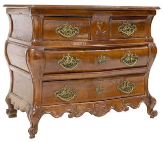
FRENCH LOUIS XV FOUR-DRAWER BOMBE COMMODE, 18TH C.Austin Auction Gallery4.7(1.2k)See Sold PriceFeb 25, 2024
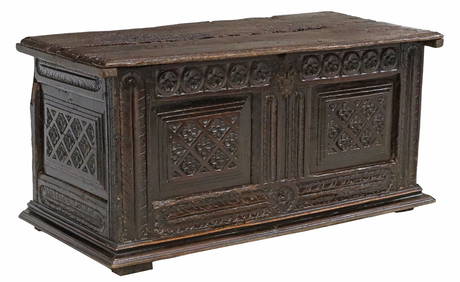
ANTIQUE FRENCH CARVED OAK COFFER OR TRUNK, 18TH C.Austin Auction Gallery4.7(1.2k)See Sold PriceFeb 25, 2024
Two (2) Antique 18th C. Copper Engraved Framed Maps - America & EuropeMagnusson Art Group4.5(50)See Sold PriceMar 14, 2024
TWO AFRICAN IVORY COAST TRIBAL RED PAINTED GURO WOOD MASKS. Largest 44 cm x 15 cm. (2)Hannam's Auctioneers Ltd4.3(391)See Sold PriceFeb 27, 2024
THE WHOLE CHRONICLE OF POLYBIUS ANCIENT IN ENGLISH, 1756NY Elizabeth 4.3(85)See Sold PriceMar 03, 2024
PUBLIUS TERENTIUS AFER COMOEDIAE SEX, TWO VOLUMES OF ANTIQUE POETRY, 1779 TERENCE COMEDIESNY Elizabeth 4.3(85)See Sold PriceMar 03, 2024
TWO 18TH C. SALEM MA CHAIRS, ATRRIB. GOULD WORKSHOP.William Smith Auctions4.6(146)See Sold PriceMar 06, 2024
TWO 18TH C. PORTSMOUTH NH CHIPPENDALE SIDE CHAIRS.William Smith Auctions4.6(146)See Sold PriceMar 06, 2024
TWO 18th C CHINESE EXPORT PAINTINGS OF MUSICIANSA.H. Wilkens Auctions & Appraisals4.7(392)See Sold PriceFeb 29, 2024
TWO 18th C DUTCH VESSELS & CANDLESTICKA.H. Wilkens Auctions & Appraisals4.7(392)See Sold PriceFeb 28, 2024