SoldBowen & Kitchin. English & Welsh County mapsBowen (Emanuel) and Thomas Kitchin. a good group of county maps of England and Wales,32 maps on 29 sheets, mostly by Bowen, but Warwickshire, Oxfordshire, Hartfordshire, Cornwall, Durham, HampSee Sold Price
SoldA mixed group of county mapsBritish Isles.- A mixed group of county maps, Worcestershire, Devonshire, Westmoreland, Shropshire, Derbyshire, Middlesex, Northumberland, Durham, Glocestershire, Shropshire, for or by W.Kip,See Sold Price
SoldMorden (Robert) A group of 12 county mapsMorden (Robert) A group of 12 county mapsincluding Middlesex, Hertfordshire, The Isle of White and The Smaller Islands in The British Ocean, engraved maps, original hand-colouring, 360 x 420 mSee Sold Price
SoldGreenwood (C. & J.) A group of 5 county mapsGreenwood (C. & J.) A group of 5 county maps,the Counties of Berks, Middlesex, Somerset, Southampton and Wilts, all with vignette views, engraved maps with original hand-colouring, each c.620See Sold Price
SoldA mixed group of English county mapsA mixed group of English county maps,including 3 maps by Morden, 2 of Wiltshire, 1 of Hampshire, an Ogilby road map from 'Monmouth to Llanbeder, c.1676, a Bowen map of Middlesex, and 6 othersSee Sold Price
SoldGROUP LOT OF PAPER GOODSNEW YORK AND NEW JERSEY INCLUDING - MAP OF SUSSEX COUNTY NEW JERSEY 1935, SUSSEX COUNTY BOOKLET, (2) CIVIL LIST OF DEERPARK 1891, MIDDLETOWN NEW YORK 1893, AND SOUVENIR BOOK OF WARWICKSee Sold Price
SoldPenna Geological Survey 13 Maps Lancaster Co.Penna Geological Survey 13 Maps Lancaster Co. 2nd Geological Survey. Lancaster County Maps. 13 folding maps in slipcase, circa 1890s. Condition: Very Good.See Sold Price
A mixed group of mostly smaller maps of the county,including Drayton's Poly-olbion map of Sussex, Surrey and Middlesex, 2 variant states of the Norden/Kip map for Camden's Britannia, Ogilby's strip road map from London to Rye, and others by Blome, MorSee Sold Price
Sold1860 Shearer's Map of York County Pennsyvlania.1860 Shearer's Map of York County Pennsyvlania. 63"h. x62"w. Condition: Good with minor losses.See Sold Price
Sold19th C. Map of Middlesex County, England, Print19th Century hand-colored print, "Map of the County of Middlesex from an Actual Survey made in the Years 1819 & 1820 by C.&I. Greenwood", London, 23" x 28", in frame 27 1/2" x 35". Good condition.See Sold Price
SoldAn Authentic History of Lancaster County, by J. I.An Authentic History of Lancaster County, by J. I. Mombert, D.D.; publ. by J.E. Barr & Co., Lancaster, PA., 1869. Map included at title page. Rebound. Good condition.See Sold Price
SoldAn Authentic History of Lancaster County, by J. I.An Authentic History of Lancaster County, by J. I. Mombert, D.D.; publ. by J.E. Barr & Co., Lancaster, PA., 1869. Map included at title page. Rebound. Good condition.See Sold Price
Sold(Juniata and other PA history/folklore) 29" x 49"(Juniata and other PA history/folklore) 29" x 49" linen backed map of the public roads in Juniata County (1905, VG); JUNIATA MEMORIES by Henry Shoemaker, 395pp. 1916, 1st good; MOUNTAIN MINSTRELSY OFSee Sold Price
SDUK A good group of maps of EuropeSociety For The Diffusion Of Useful Knowledge (The) A group of maps of Europe,map of the Continent, city plans of Constantinople, Toulon and Munich, national and regional maps of the British ISee Sold Price
SoldEngland.- A mixed group of county mapsEngland.- A mixed group of county maps,Kent, Herefordshire, Surrey, Westmoreland, Hertfordshire, Worcestershire, by or after Blome, Simpson, Morden, Moule, and Cary, engravings, some hand-coloSee Sold Price
Middlesex County / Smith MAP OF Hartford County Connecticut 1855Description: Middlesex County / Smith MAP OF Hartford County Connecticut 1855Material: PaperSee Sold Price
1904 Boston Area Middlesex County Large Map1904 Boston Area Middlesex County Large Map Has tear and creases and dry mounted on board 34 x 37 1/2 Shipping in continental US $45.00 Please ask any questions before bidding Good Luck!See Sold Price
SDUK A good group of maps of AmericaSociety For The Diffusion Of Useful Knowledge (The) A group of maps of America,including an index map and 11 of 13 sheets of North America, others of the West Indies, Central and South AmericaSee Sold Price
SoldCary (John) A Group of County MapsCary (John) A Map of Dorsetshire; A Map of Hampshire,2 engraved maps, 375 x 520mm., and 520 x 435mm., respectively, horizontal and vertical folds, the former with light offsetting, the latterSee Sold Price
SDUK A good group of maps of AsiaSociety For The Diffusion Of Useful Knowledge (The) A group of maps of Asia,including map of the Continent, a good group of India, islands in the Pacific and Indian oceans, China and Malaysia,See Sold Price
SoldCambridgeshire.- a mixed group of county mapsCambridgeshire.- a mixed group of small county maps,some with inset plans or vignette views and other ornamentation, by, for or after Blome, Cary, Moll, Morden, Moule, Ramble, Rocque, Seller,See Sold Price
SoldMoule (Thomas) A group of county mapsMoule (Thomas) A group of county maps,including Hertfordshire, Kent, Buckinghamshire, Cornwall, and Berkshire, all with ornamental borders incorporating vignette views and scenes, hand-coloureSee Sold Price
SoldEngland.- a mixed group of county mapsa mixed group of county maps,Bedfordshire, Berkshire, Buckinghamshire, Cumberland, Oxfordshire and Somerset, several versions of the the first three named, by, for or after Archer, Lewis, MurSee Sold Price
SoldWales.- A small, mixed group of county mapsWales.- A small, mixed group of county mapsby or after Walker, Weller, Pigot and others, including Monmouthshire, Glamorganshire and elsewhere with a plan of Cardiff, engraved maps, some hand-See Sold Price
Rand McNally Township County and Railroad Map of Indiana-1880JM Hobby Supply and Railroad Artifact Auctions4.4(126)See Sold PriceFeb 24, 2024
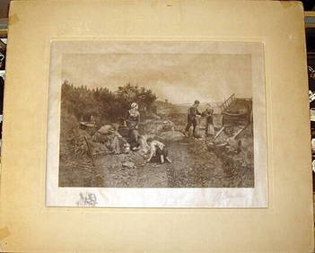
Daniel Ridgway Knight Engraving Signed by Courtauld Potato Helling 17" x 13"Luis Porretta Fine Arts4.3(10)See Sold PriceMar 02, 2024
DUNLEVIE c1856 Map Counties Of Gaspe & Bonaventure Quebec Canada SCARCE! #2Luis Porretta Fine Arts4.3(10)See Sold PriceMar 02, 2024
DUNLEVIE c1856 Map Counties Of Gaspe & Bonaventure Quebec Canada SCARCE! #1Luis Porretta Fine Arts4.3(10)See Sold PriceMar 02, 2024
Group of Three Wadhams Mobil Road MapsCheck the Oil Promotions, LLC4.6(275)See Sold PriceFeb 25, 2024
Group of Standard Oil Family Road MapsCheck the Oil Promotions, LLC4.6(275)See Sold PriceFeb 25, 2024
Portfolio of 15 County Maps by Robert Morden (English 1650-1703)Nadeau's Auction Gallery4.7(401)See Sold PriceFeb 24, 2024
Rand McNally & Co's New Ideal State and County Survey and Atlas 1911North American Artifact Auctions4.6(182)See Sold PriceApr 20, 2024
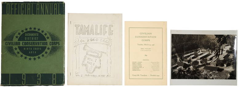
VARIOUS ARTISTS [BRITISH TRAVEL GUIDES]. Group of 6 map booklets and flyers. 1930s.Swann Auction Galleries4.4(65)See Sold PriceFeb 29, 2024
Framed Collection Engravings & A Map From The Excursions In The County Of Sussex Published In 1822Rapid Estate Liquidators and Auction Gallery4.5(1.1k)See Sold PriceMar 01, 2024
A GROUP OF ELEVEN HORNBY OO GAUGE LOCOMOTIVES AND A TRACK PACKChiswick Auctions4.3(82)See Sold PriceJun 21, 2024


![VARIOUS ARTISTS [BRITISH TRAVEL GUIDES]. Group of 6 map booklets and flyers. 1930s. (1 of 2)](https://p1.liveauctioneers.com/199/319703/171640571_1_x.jpg?height=282&quality=70&version=1707943705)