ATLAS of ANTIENT GEOGRAPHY by SAMUEL BUTLER 1843John McInnis Auctioneers,LLC4.6(502)See Sold PriceFeb 24, 2024
18TH C. ANTIQUE MAP: FRENCH & INDIAN WAR, FRAMEDThomaston Place Auction Galleries4.4(386)See Sold PriceFeb 24, 2024
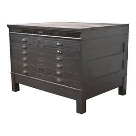
Rand McNally Railroad Map Cabinet w/ 21 Railroad MapsRail & Road Auctions4.6(165)See Sold PriceMar 08, 2024
Keith Haring - Ink on New York Map, Best Buddies, Inscribed, Signed, and DatedSapphire Auction Gallery4(67)See Sold PriceMar 02, 2024
LATE 17TH C. FRENCH MAP OF THE NEW WORLD BY ALEXIS-HUBERT JAILLOT (1632-1712)Thomaston Place Auction Galleries4.4(386)See Sold PriceFeb 24, 2024
Central Railroad of New Jersey Map of Sandy Hook Route-ca. 1903JM Hobby Supply and Railroad Artifact Auctions4.4(126)See Sold PriceFeb 24, 2024
Lot of Six Mixed Atlas Box Cars-HO Scale-New in BoxJM Hobby Supply and Railroad Artifact Auctions4.4(126)See Sold PriceFeb 25, 2024
Rand McNally/Santa Fe Railroad Map of Iowa-1912JM Hobby Supply and Railroad Artifact Auctions4.4(126)See Sold PriceFeb 24, 2024
NICOLAES VISSCHER (NETHERLANDS, 1618-1709) MAP OF THE NEW WORLDThomaston Place Auction Galleries4.4(386)See Sold PriceFeb 24, 2024
17TH C. WORLD MAP BY NICOLAES VISSCHER (NETHERLANDS, 1618-1709)Thomaston Place Auction Galleries4.4(386)See Sold PriceFeb 24, 2024
Lot of Six Mixed Atlas Cabooses-HO Scale-New in BoxJM Hobby Supply and Railroad Artifact Auctions4.4(126)See Sold PriceFeb 25, 2024
SoldPenna Geological Survey 13 Maps Lancaster Co.Penna Geological Survey 13 Maps Lancaster Co. 2nd Geological Survey. Lancaster County Maps. 13 folding maps in slipcase, circa 1890s. Condition: Very Good.See Sold Price
Sold446: New Jersey Geological Survey maps, 1889, George CoNew Jersey Geological Survey maps, 1889, George Cook, cartographer, a suite of wall charts, each measuring approx. 36" x 48", along with index sheet, in a wooden field box.See Sold Price
SoldGROUPING OF FRAMED MAPSIncluding mostly maps of Connecticut, also including a pair of US geological survey maps. Also including vintage J. H. Colton & Co. map of Connecticut. Also included is a reproduction of 1785 map of tSee Sold Price
Sold[NEW JERSEY] Geological Survey of New Jersey. Maps[NEW JERSEY] Geological Survey of New Jersey. Maps. 1868 Cook, George, State Geologist and Smock, John C. Asst. Geologist. Green cloth folder with 13 map sheets of various sizes from 14 x 17 to 24 xSee Sold Price
1946 NY Naples Quadrangle Geological Survey MapDescription: 1946 NY Naples Quadrangle Geological Survey Map, reprinted from a 1903 edition. H.M. Wilson, geographer in charge, control by W.T. Griswold and W.W. Gilbert, topography by J.H. Jennings.See Sold Price
Four 19th Century Maryland Geological Survey Maps19th century. Four geological maps of Maryland from the Maryland Geological Survey. Printed by A. Hoen & CO. Balto. 17.5 x 10 inches each. Chipping/wear at edges; overall good condition.See Sold Price
1944 Tioga County Owego Quadrangle Geological SurveyDescription: 1944 Tioga County Owego Quadrangle Geological Survey Map, reprinted from a 1903 edition. H.M. Wilson, geographer in charge, control by NY State Survey and W.W. Gilbert, topography by J.H.See Sold Price
SoldANTIQUE LINED MA NY VT TACONIC QUADRANGLE MAPdepartment of interior US geological survey map. has been lined and cut . current measurement 17 3/4" by 13". map shows some highlighted travel routeSee Sold Price
Sold1970s-80s INTERPLANETARY GEOLOGIC MAPS (x13)Lot of 13 different maps from US Geological Survey including Apollo 14 through Apollo 17 lunar maps, maps of Mars, Venus, Mercury and more. All are housed in original jackets. Interesting material.See Sold Price
Oil Map of Katalla field in Alaska c.1925Title: Map of Katalla Oil Field Prepared for Sinclair Oil Co... Topography from Maps of U.S. Geological Survey Author: Ver Wiebe, W.A. Description: Blue-line map, with hand-coloring. 75x108 cm. (29½xSee Sold Price
SoldOil Map of Katalla field in Alaska c.1925Title: Map of Katalla Oil Field Prepared for Sinclair Oil Co... Topography from Maps of U.S. Geological Survey Author: Ver Wiebe, W.A. Description: Blue-line map, with hand-coloring. 75x108 cm. (29½xSee Sold Price
Sold1914 Glacier National Park Topographic MapThis is an original topographic map of Glacier National Park from 1914. The cover of the map is marked "Glacier National Park Great Northern Railway United States Geological Survey Map. The map was puSee Sold Price
Lewis and Clark Forest Reserve Montana ShowingTitle: Lewis and Clark Forest Reserve Montana Showing Classification of Lands Publication Date: 1899 Cartographer: AYRES, H. B. Publisher: U.S. GEOLOGICAL SURVEY 14 X 13.75 Additional Information: TweSee Sold Price
SoldLot of 3 large maps, US Geological Survey by PikeLot of 3 large maps, US Geological Survey by Pikes Peak Lithographing Co, CO. 1) Florida 1995, 2) Georgia 1994, 3) Michigan 1995. Approximate size 44" x 47".See Sold Price
Oregon Ashland QuadrangleTitle: Oregon Ashland Quadrangle Publication Date: 1899 Cartographer: LEIBERG, JOHN B. Publisher: U.S. GEOLOGICAL SURVEY 17.5 X 13 Additional Information: Plate LXXI Twenty-first annual report Part VSee Sold Price
North Creek, NY MapNorth Creek, NY Map ca. 1960 paper 22.25" W x 27.13" H Lithographed topographical map of North Creek, NY, Dated 1968. Mapped, edited and published by the Geological Survey of the US Dept. of the InterSee Sold Price
Porter Corners, NY Topographical MapPorter Corners, NY Topographical Map ca. 1960 paper 22.13" W x 27.13" H Dated 1968 topographical map of Porter Corners, NY. Mapped, edited, and published by the Geological Survey of the US Dept. of thSee Sold Price
Chestertown NY Topographical MapChestertown NY Topographical Map ca. 1960 paper 22.13" W x 27.13" H Dated 1968 topographical map of Chestertown, NY, mapped, edited and published by the Geological Survey of the US Dept. of the InteriSee Sold Price
Port Leyden, NY Topographic MapPort Leyden, NY Topographic Map ca. 1960 paper 22.25" W x 27.13" H Dated 1966 topographical map of Port Leyden, NY. Mapped, edited, and published by the Geological Survey of the US Dept. of the InteriSee Sold Price
SoldLarge colored map of Shasta Co. CA 1912Heading: (California - Shasta County) Author: Wiegel, C. R. Title: Map of the County of Shasta California. Compiled from U.S. geological and U.S. land surveys, official and private surveys, etc. by C.See Sold Price
SoldLot of 2 Post Civil War buttonsLot of two Post Civil War: (1) Geological Survey. Convex with a relief triangle/hammers with 13 stars. Reverse marked "WARNOLK UNIFORM CO. NEW YORK" FD 44. (2) Lighthouse Service. Gilt relief lighthouSee Sold Price
Stony Creek NY Topographical MapStony Creek NY Topographical Map ca. 1960 paper 22.25" W x 27.13" H Dated 1968 lithographed topographical map of Stony Creek, NY. Mapped, edited, and published by the Geological Survey of the US Dept.See Sold Price
SoldArid Region of the U.S. Map 1891 This is the AridThis is the Arid Region of the United States showing Forest Areas. The map is done by Sackett & Wilhelms Lith. Co. N.Y. and is the U.S. Geological Survey Eleventh Annual Report Part II. PL. LXVIII 189See Sold Price
Sold(3) MAPS: UNITED STATES, MARTHA'S VINEYARD, EUROPE(lot of 3) Framed maps, including: (1) Martha's Vineyard, U.S. Geological Survey, sight: 10.25"h, 14.25"w, overall: 12"h, 16"w, (1) Hungarian map of Europe, sight: 8.25"h, 10"w, overall: 13.25"h, 15"wSee Sold Price
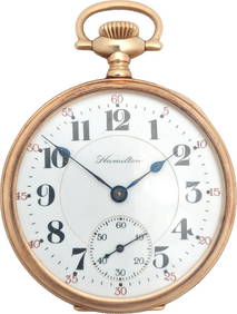
CASED HAMILTON WATCH CO. MARINE CHRONOMETER Lancaster, Pennsylvania, 20th Century Case height 7.5".Eldred's4.7(409)See Sold PriceFeb 27, 2024
Portfolio of 15 County Maps by Robert Morden (English 1650-1703)Nadeau's Auction Gallery4.7(401)See Sold PriceFeb 24, 2024
Rand McNally & Co's New Ideal State and County Survey and Atlas 1911North American Artifact Auctions4.6(182)See Sold PriceApr 20, 2024
Pabst Blue Ribbon Beer Bottle Steiniue TOC Sign MINTYMorean Auctions4.5(31)See Sold PriceFeb 25, 2024
Antique Cast Iron Boston and Terrier Dog DoorstopsHill Auction Gallery 4.7(1k)See Sold PriceFeb 28, 2024
Antique Arts & Crafts Ebonized Oak Architect's Blueprint Flat File Cabinet, Circa 1900Liberty & 33rd Furniture Co.4.4(11)See Sold PriceFeb 27, 2024
Antique Arts & Crafts Oak Architect's Blueprint Flat File Cabinet, Circa 1900Liberty & 33rd Furniture Co.4.4(11)See Sold PriceFeb 27, 2024
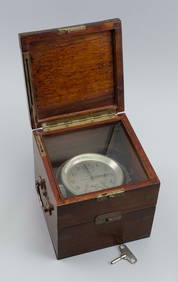
Heavy 14K Gold 23J Hamilton 950 Railroad Pocket Watch Double Sunk DialHess Fine Auctions4.5(197)See Sold PriceMar 02, 2024
Nottingham.- Ordnance Survey Office (publisher) Collection 8 geological maps on the environs ofForum Auctions4.3(52)See Sold PriceFeb 29, 2024
Vintage Holy Bible Old & New Testaments Illustrated 1904The Benefit Shop Foundation Inc.4.3(2.9k)See Sold PriceMar 13, 2024
Virginia and West Virginia Topography MapsRapid Estate Liquidators and Auction Gallery4.5(1.1k)See Sold PriceFeb 28, 2024


![[NEW JERSEY] Geological Survey of New Jersey. Maps (1 of 3)](https://p1.liveauctioneers.com/46/23326/8239689_1_x.jpg?height=282&quality=70)