SoldILLUSTRATED MAP OF THE WORLD by TUNISON, 1880Historic MapsTunison's "Illustrated Map of the World", With People of the World c. 1886, "AN ILLUSTRATED MAP OF THE WORLD", by H.C. Tunison, Jacksonville, Illinois, Very Good. ThisSee Sold Price
SoldILLUSTRATED MAP OF THE WORLD by TUNISON, 1880Historic MapsTunison's "Illustrated Map of the World", With People of the World c. 1886, "AN ILLUSTRATED MAP OF THE WORLD", by H.C. Tunison, Jacksonville, Illinois, Very Good. ThisSee Sold Price
Sold1880 Verne Around the World + Doctor Ox1880 Verne Around the World + Doctor Ox French Literature Illustrated MAP 2in1 Jules Verne’s adventure novels are some of the most popular and famous works of literature of all time. Known mostly foSee Sold Price
SoldJOHNSON'S NEW ILLUSTRATED FAMILY ATLAS OF THE WJOHNSON'S NEW ILLUSTRATED FAMILY ATLAS OF THE WORLD, 1880, COVER SEPARATED & 2 MAPS RUMPLED AT EDGESSee Sold Price
1880 Map of AsiaAuthor: Watson Title: 1880 Map of Asia Medium: Ink on Paper Dimensions: 21"X14.5" Description: Double folio map of Asia dated 1880. Rather rare. Part of Watson's 1880 Illustrated Atlas of the World. PSee Sold Price
Sold1880 Astronomy ChartAuthor: Watson Title: 1880 Astronomy Chart Medium: Ink on Paper Dimensions: 14"X11" Astronomy chart dated 1880. Rather rare. Part of Watson's 1880 Illustrated Atlas of the World. Published by Iliff&coSee Sold Price
1880 Astronomy ChartAuthor: Watson Title: 1880 Astronomy Chart Medium: Ink on Paper Dimensions: 14"X11" Description: Astronomy chart dated 1880. Rather rare. Part of Watson's 1880 Illustrated Atlas of the World. PublisheSee Sold Price
Sold1880 Arbuckles' Illustrated Atlas of the World"Arbuckles Illustrated Atlas of Fifty Principal Nations of the World" in pamphlet/book form, 24 pages including front and back cover, each with illustrations and map insets, complete with all pages, 7See Sold Price
Sold3 Books, Illustrated History Wyoming County Etc3 Books, Illustrated History of Wyoming County NY 1840-1880, 20th C. Illustrated Atlas of the World 1901, McNally's System of Geography BookSee Sold Price
Sold1836 1st ed World As It Is Perkins Slavery Indians1836 1st ed World As It Is Perkins Slavery Indians Ireland Egypt Illustrated MAP ‘The World As It Is’ was written by Samuel Perkins to give a concise view of the nations of the world as it relatesSee Sold Price
SoldCOLTON'S NEW ILLUSTRATED MAP OF THE WORLDCOLTON'S NEW ILLUSTRATED MAP OF THE WORLD 1859. SIGHT 31 X 43" (MINOR ARCHIVAL REPAIRS) **DUE TO THE SIZE AND/OR FRAGILITY OF THIS LOT, STANDARD IN HOUSE SHIPPING IS NOT AVAILABLE. THE BUYER IS RESPONSee Sold Price
SoldNew Illustrated Map of the WorldJ.H. Colton (1800 – 1893). New York: J.H. Colton, 1853. 44 1/2 x 33 5/8 inches. Not a cartographer or engraver himself, Colton’s initial business practice mostly involved purchasing the copyrightsSee Sold Price
SoldIllustrated Van Loon Hand-Colored World Map, 1932Hendrik Willem Van Loon (Dutch-American, 1882-1944). Illustrated World Map, 1932. A hand colored outlined pictorial map of the world on Mercator projections with topographical relief shown pictoriallySee Sold Price
SoldAir France. Paris: Perceval, 1950s. One-sheet (22 xAir France. Paris: Perceval, 1950s. One-sheet (22 x 36”). Strong image of illustrated world map showing Air France routes of the period. Vibrant colors. Linen mounted. A.See Sold Price
Illustrated Van Loon Hand-Colored World Map, 1932Hendrik Willem Van Loon (Dutch-American, 1882-1944). Illustrated World Map, 1932. A hand colored outlined pictorial map of the world on Mercator projections with topographical relief shown pictoriallySee Sold Price
Map of the World, Published by Colton 1853Title: Colton's New Illustrated Map of the World on Mercator's Projection. Published by J.H. Colton, New York. Handcolored engraving, 1853. Size 43 3/4 x 32 1/2" (111 x 82.5 cm). Large item shipmentSee Sold Price
Colton's New Illustrated Map Of The WorlColton's New Illustrated Map Of The World, On Mercator's Projection Published by J. H. Colton & Co., #172 William Street, New York, 1856; map has been laid to board and has crinkling. frame size: H34See Sold Price
Illustrated Van Loon Hand-Colored World Map, 1932**First Time At Auction** Hendrik Willem Van Loon (Dutch-American, 1882-1944). Illustrated World Map, 1932. A hand colored outlined pictorial map of the world on Mercator projections with topographicaSee Sold Price
Cortambert: Antique Map of World in Hemispheres, 1880Mappemonde en deux Hémisphères; Ancien ou 1er. Continent; Nouveau ou 2me. Continent; Terms Géographiques et signes conventionnels; Golfe (Golfe de Gènes); Péninsule (Morée); Golfe de la Seine; OSee Sold Price
Sold1883 1st Esoteric Occult Rivers of Life Forlong1883 1st Esoteric Occult Rivers of Life Forlong World Religions MAP Illustrated Major-General Forlong was a military engineer and scholar of world religions. Forlong’s ‘Rivers of Life’ is a two-See Sold Price
SoldIllustrated MapsA collection of (13) 19th and 20th century illustrated maps from around the world. London, Cape Cod, Sicily, and more!See Sold Price
Geography Made Easy: Being an AbridgementGeography Made Easy: Being an Abridgement of the American Universal Geography. MORSE, JEDIDIAH. THOMAS & ANDREWS. To which are prefixed Elements of Geography... Illustrated by maps of the world, and oSee Sold Price
SoldFramed Johnson & Ward map of world hand colored c. 1880well executed map from the period 21" x 33"See Sold Price
Sold(2) BOOKS: WORLD WAR I, ILLUSTRATED, MAPS, PHOTOS(lot of 2) " A Guide to the American Battle Fields in Europe", American Battle Monuments Commission, USGPO, 1927, illustrated with many photographs, fold out color highlighted maps, three large removaSee Sold Price
Eretz Israel Map Postcard - World Zionist OrganizationLevy Auction House4.3(11)See Sold PriceFeb 27, 2024
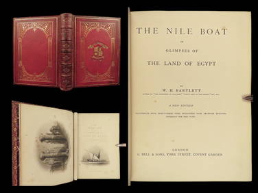
1880 Niles Boat Egypt Voyages Sphinx Pyramids Valley of Kings Illustrated MAPSSchilb Antiquarian Rare Books4.8(421)See Sold PriceMar 31, 2024
1880 Mark Twain 1st ed A Tramp Abroad Travel Illustrated Satire Alps CLASSICSchilb Antiquarian Rare Books4.8(421)See Sold PriceMar 31, 2024
Universal World History Illustrated Bks 8, 1929The Benefit Shop Foundation Inc.4.3(2.9k)See Sold PriceMar 06, 2024
1738 BIBLE in DUTCH ILLUSTRATED w/ MAPS antique MASSIVE FOLIO BIBLIAJasper524.5(9.8k)See Sold PriceFeb 27, 2024
1730 BIBLE in DUTCH ILLUSTRATED w/ MAPS antique MASSIVE FOLIO BIBLIAJasper524.5(9.8k)See Sold PriceFeb 27, 2024
Vintage Holy Bible Old & New Testaments Illustrated 1904The Benefit Shop Foundation Inc.4.3(2.9k)See Sold PriceMar 13, 2024
1792 OLD INDIA HISTORY ANTIQUE ILLUSTRATED WITH MAPS OF THE EIGHTEENTH CENTURY IN FRENCHNY Elizabeth 4.3(84)See Sold PriceMar 03, 2024
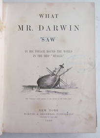
1880 WHAT MR. DARWIN SAW IN SHIP BEAGLE ANTIQUE DURING HIS WORLD TOURNY Elizabeth 4.3(84)See Sold PriceMar 03, 2024
Joseph Williamson Ludlow (1840 - 1916) - Set of 2 Bird Prints - Aylesbury Ducks - Toulouse GeeseProverde Auctions4.3(3)See Sold PriceFeb 28, 2024
Joseph Williamson Ludlow (1840 - 1916) - Set of 2 Bird Prints - White-faced black Spanish - WhiteProverde Auctions4.3(3)See Sold PriceFeb 28, 2024