Charles & Ray Eames for Herman Miller Lounge ChairAuctions at Showplace4.5(726)See Sold PriceMar 03, 2024
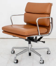
Eames for Herman Miller Executive Soft Pad ChairAuctions at Showplace4.5(726)See Sold PriceMar 03, 2024
Lewis Mittman Upholstered Club Chair and OttomanNadeau's Auction Gallery4.7(401)See Sold PriceFeb 24, 2024
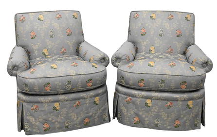
Chintz Tufted Upholstered Club Chair with a Matching Slipper Chair, Designed by Mario BuattaSTAIR4.6(286)See Sold PriceMar 06, 2024
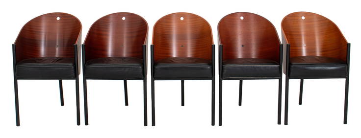
Philippe Starck x Aleph "Costes" Sapele Chairs, 5Auctions at Showplace4.5(726)See Sold PriceMar 03, 2024
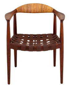
Hans Wegner for J. Hansen JH-501 Teak Arm ChairAuctions at Showplace4.5(726)See Sold PriceMar 03, 2024
Pair of Lewis Mittman Incorporated Custom Upholstered Swivel ArmchairsNadeau's Auction Gallery4.7(401)See Sold PriceFeb 24, 2024
Pair of Mid Century Modern Barrel back ArmchairsBodnar's Auction Sales4.6(609)See Sold PriceMar 06, 2024
A pair of Gio Ponti for M. Singer and Sons lounge chairsJohn Moran Auctioneers, Inc.4.7(453)See Sold PriceFeb 27, 2024
Map of the World, Published by Colton 1853Title: Colton's New Illustrated Map of the World on Mercator's Projection. Published by J.H. Colton, New York. Handcolored engraving, 1853. Size 43 3/4 x 32 1/2" (111 x 82.5 cm). Large item shipmentSee Sold Price
SoldEarly United States Roll-Up MapEarly United States roll-up map. Published by J. H. Colton / New York / 1853. 44 1/2" x 36".See Sold Price
SoldColton map of Washington & Oregon 1853Washington and Oregon map. Published by J. H.Colton & Co, New York, 1853. Lithographed map, hand-colored. Pacific Northwest showing both territories extending to the Continental Divide and including tSee Sold Price
World MapTitle: World Map Artist: J.H. Colton Medium: ink on paper Dimensions: 28" x 17.5" World map dated 1855. Published by J.H. Colton in New York and London. Mercantile map engraved on a steel plate. FullSee Sold Price
SoldColton's 1855 Southern Regions Map of AntarcticaFrom Colton's 1856 Atlas of the World, published at Colton's 172 William St. office in New York. Nibbled edges and slight fading. Measures approximately 17-1/2" in height by 14-1/2" in width.See Sold Price
Colton's 1855 Southern Regions Map of AntarcticaFrom Colton's 1856 Atlas of the World, published at Colton's 172 William St. office in New York. Nibbled edges and slight fading. Measures approximately 17-1/2" in height by 14-1/2" in width.See Sold Price
Colton's 1855 Southern Regions Map of AntarcticaFrom Colton's 1856 Atlas of the World, published at Colton's 172 William St. office in New York. Nibbled edges and slight fading. Measures approximately 17-1/2" in height by 14-1/2" in width.See Sold Price
Sold1856 COLTON MAP CHARLESTON SCMap is from Colton's Atlas Of The World published by J.H. Colton And Company, 1856. Map was of Charleston, South Carolina and Savannah, Georgia. Framed with only Charleston showing. Professionally fraSee Sold Price
Colton's New Illustrated Map Of The WorlColton's New Illustrated Map Of The World, On Mercator's Projection Published by J. H. Colton & Co., #172 William Street, New York, 1856; map has been laid to board and has crinkling. frame size: H34See Sold Price
SoldRare Colton folding map of U.S. 1853Heading: Author: Colton, Joseph Hutchins Title: The United States of America 1853 Place Published: New York Publisher:Published by J.H. Colton Date Published: 1853 Description:See Sold Price
SoldNew Illustrated Map of the WorldJ.H. Colton (1800 – 1893). New York: J.H. Colton, 1853. 44 1/2 x 33 5/8 inches. Not a cartographer or engraver himself, Colton’s initial business practice mostly involved purchasing the copyrightsSee Sold Price
Sold1855 map of Conn/NY/R. IslandBeautiful map with rich hand color and crisp impression. Extra clean and bright. From the 1856 edition of Colton’s Atlas of the World published by J. H. Colton. Just a hint of toning to extreme outsSee Sold Price
1855 map of Conn/NY/R. IslandBeautiful map with rich hand color and crisp impression. Extra clean and bright. From the 1856 edition of Colton’s Atlas of the World published by J. H. Colton. Just a hint of toning to extreme outsSee Sold Price
SoldColton’s 1855 Florida – Johnson & BrowningReserve Reduced! Colton's early map of Florida from Colton’s 1856 Atlas of the World, published by J. H. Colton. Like most of Colton's state maps, this map is largely derived from an earlier wall maSee Sold Price
SoldColton: Antique Map of the World, 1861Title/Content of Map: World by Colton Date Printed: 1861 Cartographer: J.H. Colton Material/Medium: Paper Size: 25" x 17 1/3" Hand colored steel engraved. From Colton's 'General Atlas'. Published in NSee Sold Price
Sold19thc J.H. Colton Map of FranceOriginal 19th Century map of France, No.7, from an 1855 edition of Colton's Atlas of The World, published in New York. Map details the various regions, plus a small inset map of Corsica. 14" X 17".See Sold Price
SoldJ. H. Colton's Map of United StatesIncluding US, British Provinces, Mexico, and West Indies. Published by J.H. Colton, New York, 1853. 59" x 53".See Sold Price
Colton's 1853 Railroad & Township MapHeading: Author: Colton, J.H. Title: Colton's Railroad & Township Map of Western States Compiled From The United States Surveys Place Published: New York Publisher:J. H. Colton Date Published: <See Sold Price
Colton's Map of the World on Mercator's Projection 1861Heading: Author: Colton, J.H. Title: Colton's Map of the World on Mercator's Projection 1861 Place Published: New York Publisher:J.H. Colton Date Published: 1861 Description: <See Sold Price
SoldColton's Map of the World 1855Colton's Map of the World on Mecator's Projection. Entered according to Act of Congress in the year 1855. Published by J. H. Colton & Co. Measures 18.5" x 29.25". Fold at center with paper seam on verSee Sold Price
SoldMitchell Map of the World, 1850Beautiful hand colored map of the world originally created by S. Augustus Mitchell in 1850. Thomas, Cowperthwait & Co. bought out Mitchell in 1850. They published this map in 1853. Shows the world onSee Sold Price
1855 Colton map of IllinoisVery nice hand color and impression. Clean and bright. Pinhead spot in image. Small dot in lower margin. Inset of Chicago. From the 1856 edition of Colton’s Atlas of the World published by J. H. ColSee Sold Price
SoldJ.H. COLTON HAND COLORED MAP OF BOSTON, 1855Joseph Hutchins Colton, American (1800-1893). Hand-colored engraving titled "Colton's Map of Boston and Adjacent Cities". Plate No. 13 from Colton's "Atlas of the World", published by Johnson & BrowniSee Sold Price
Mitchell Map of the World, 1850Beautiful hand colored map of the world originally created by S. Augustus Mitchell in 1850. Thomas, Cowperthwait & Co. bought out Mitchell in 1850. They published this map in 1853. Shows the world onSee Sold Price
Eretz Israel Map Postcard - World Zionist OrganizationLevy Auction House4.3(11)See Sold PriceFeb 27, 2024
1853 Colton's Railroad & Township Map of Massachusetts, Rhode Island, and ConnecticutRail & Road Auctions4.6(165)See Sold PriceMar 07, 2024
Carey, pub. 1796 - Map of GeorgiaTrillium Antique Prints & Rare Books4.5(30)See Sold PriceFeb 24, 2024
Carey, pub. 1796 - Map of The State of South CarolinaTrillium Antique Prints & Rare Books4.5(30)See Sold PriceFeb 24, 2024
Carey, pub. 1796 - Map of KentuckyTrillium Antique Prints & Rare Books4.5(30)See Sold PriceFeb 24, 2024
Carey, pub. 1796 - Map of the Tennassee State formerly part of North Carolina (Tennessee)Trillium Antique Prints & Rare Books4.5(30)See Sold PriceFeb 24, 2024
West Africa. Liberia Sahara Senegambia Guinea. Mountains of Kong COLTON 1869 mapJasper524.5(9.8k)See Sold PriceFeb 28, 2024
Blackie (Pub) 1882 Folio Map. World on Mercators ProjectionAlbion Auctions4.6(336)See Sold PriceMar 01, 2024
Perry, Matthew C. 1856 Large Map. Shah Bay, Lew Chew I. JapanAlbion Auctions4.6(336)See Sold PriceMar 01, 2024
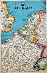
Vintage Map - Krigskarta - War Map - Second World War, published 1940Proverde Auctions4.3(3)See Sold PriceFeb 28, 2024