ATLAS of ANTIENT GEOGRAPHY by SAMUEL BUTLER 1843John McInnis Auctioneers,LLC4.6(502)See Sold PriceFeb 24, 2024
18TH C. ANTIQUE MAP: FRENCH & INDIAN WAR, FRAMEDThomaston Place Auction Galleries4.4(386)See Sold PriceFeb 24, 2024
Rand McNally Railroad Map Cabinet w/ 21 Railroad MapsRail & Road Auctions4.6(165)See Sold PriceMar 08, 2024
Keith Haring - Ink on New York Map, Best Buddies, Inscribed, Signed, and DatedSapphire Auction Gallery4(67)See Sold PriceMar 02, 2024
LATE 17TH C. FRENCH MAP OF THE NEW WORLD BY ALEXIS-HUBERT JAILLOT (1632-1712)Thomaston Place Auction Galleries4.4(386)See Sold PriceFeb 24, 2024
Central Railroad of New Jersey Map of Sandy Hook Route-ca. 1903JM Hobby Supply and Railroad Artifact Auctions4.4(126)See Sold PriceFeb 24, 2024
Lot of Six Mixed Atlas Box Cars-HO Scale-New in BoxJM Hobby Supply and Railroad Artifact Auctions4.4(126)See Sold PriceFeb 25, 2024
Rand McNally/Santa Fe Railroad Map of Iowa-1912JM Hobby Supply and Railroad Artifact Auctions4.4(126)See Sold PriceFeb 24, 2024
NICOLAES VISSCHER (NETHERLANDS, 1618-1709) MAP OF THE NEW WORLDThomaston Place Auction Galleries4.4(386)See Sold PriceFeb 24, 2024
17TH C. WORLD MAP BY NICOLAES VISSCHER (NETHERLANDS, 1618-1709)Thomaston Place Auction Galleries4.4(386)See Sold PriceFeb 24, 2024
Lot of Six Mixed Atlas Cabooses-HO Scale-New in BoxJM Hobby Supply and Railroad Artifact Auctions4.4(126)See Sold PriceFeb 25, 2024
Sold4 copper engraving maps4 copper engraving maps, 18th C., 1x Rheinverlauf of F. de Wit, cartouche and borders colored, bow folds, approx. 22.5x103cm; Palatinatus Rheni of Janssonius, partially colored, approx. 38x48cm; LineSee Sold Price
Mawman: Antique Map of Greece, Sparta, 1791Title/Content of Map: Greece: Sparta & Environs, 1791 Date Printed: 1791 Cartographer: J. Mawman Material/Medium: Engraving Size: 10 1/4" x 15 1/4" Original copper engraving from the 1791 book Maps, PSee Sold Price
SoldAntique Copper Engraving Map Asia M Suetter 19th CMap of Asia, colored copper Engraving by M Suetter, circa late 1800s. Originally purchased from Old Maps & Prints Co, Bangkok, for 4,000 baht. Framed in black and gold toned frame, wear and paint lossSee Sold Price
SoldTwo J. Janssonius Copper Engraving MapsTwo J. Janssonius original copper engravings of Thuringia and Marocchi Regnum 5 3/4" x 7 1/2" and 6 1/2" x 8"See Sold Price
SoldCopper Engraving Map by BertingCopper engraving by Berting, 1616 Northumbr. Cumberlun 4 1/2" x 5 1/2"See Sold Price
SoldFramed Early Copper Engraving MapFramed early copper engraving map "La Grande Tartarie - Par le Sr. Sarson d'Abbeville" 7 1/2" x 9 1/4"See Sold Price
SoldCIRCA 1756 MAP OF LABRADOR BY J-N. BELLINJacques-Nicolas Bellin (1703-1772, French), Chief Cartographer to the French Navy, copper engraving, map of Labrador circa 1756, from a German Atlas, hand-coloured, framed, 8 1/4 x 11 1/2 inches.See Sold Price
1630 EGYPT MAP copper engraving ANTIQUE from ENGLISH ED. Mercator-Hondius AtlasDecorative copper engraving map of EGYPT From an English Edition of the Mercator-Hondius Atlas. Amsterdam; 1630 size 4 1/4 by 7" (including margins 6 3/4 by 8 3/4") Henricus Hondius (1597-1651) was aSee Sold Price
1630 MAP OF PERSIA copper engraving ANTIQUE from English Mercator-Hondius AtlasDecorative hand colored copper engraving map of PERSIA From an English Edition of the Mercator-Hondius Atlas. Amsterdam; 1630 size 5 1/2 by 7" (including margins 6 1/4 by 7 3/4") Henricus Hondius (159See Sold Price
Mawman: Antique Map of Laconia & Island of Cythera 1791Title/Content of Map: Greece: Laconia & the Island of Cythera, 1791 Date Printed: 1791 Cartographer: J. Mawman Material/Medium: Engraving Size: 10 1/4" x 15 1/4" Original copper engraving from the 179See Sold Price
SoldMawman: Antique Map of Plan of a Grecian Palestra, 1791Title/Content of Map: Greece: Plan of a Grecian Palestra after Vitruvius, 1791 Date Printed: 1791 Cartographer: J. Mawman Material/Medium: Engraving Size: 10 1/4" x 15 1/4" Original copper engraving fSee Sold Price
Mawman: Antique Map of Aetolia & Acarnania Greece, 1791Title/Content of Map: Greece: Aetolia & Acarnania in Penninsula of Leucadia, 1791 Date Printed: 1791 Cartographer: J. Mawman Material/Medium: Engraving Size: 10 1/4" x 15 1/4" Original copper engravinSee Sold Price
Mawman: Antique Map of Pass of Thermopyle, 1791Title/Content of Map: Greece: Plan of the pass of Thermopyle, 1791 Date Printed: 1791 Cartographer: J. Mawman Material/Medium: Engraving Size: 10 1/4" x 15 1/4" Original copper engraving from the 1791See Sold Price
Mawman: Antique Map of Greece, The Hellespont, 1791Title/Content of Map: Greece: The Hellespont, Thracian Chersonesus & Troas, 1791 Date Printed: 1791 Cartographer: J. Mawman Material/Medium: Engraving Size: 10 1/4" x 15 1/4" Original copper engravingSee Sold Price
SoldTwo Copper Engravings Muller MapsTwo copper engravings by Muller, 1702 of Venice and Helveti 6" x 3 1/4" and 6" x 3 1/2"See Sold Price
SoldMap, Barbados, Pieter Van Den KeereFramed map, Pieter Van Den Keere (1571-1646), copper engraving, Barbados, map dated 1676, from the edition of 'Miniature Speeds', a small travel pocket edition, Frame: 9.5''h x 11''w, Sight: 4''h x 5.See Sold Price
U.S GOVERNMENT SURVEY COPPER MAP PLATES, SET OF 4Livingston, MT 1886-1887 US Government Copper Map Engravings for Livingston, MT, scale 1:125,000 surveyed 1886-1887. The Original Master Set engraved on 4 plates measure approximately 21 in. H x 17 inSee Sold Price
U.S GOVERNMENT SURVEY COPPER MAP PLATES, SET OF 4Livingston, MT 1886-1887 US Government Copper Map Engravings for Livingston, MT, scale 1:125,000 surveyed 1886-1887. The Original Master Set engraved on 4 plates measure approximately 21 in. H x 17 inSee Sold Price
4 BRAUN & HOGENBERG FRAMED 16TH / 17TH CENTURY MAP4 BRAUN & HOGENBERG FRAMED 16TH / 17TH CENTURY MAPS: 4 hand painted copper plate engravings, circa 1572-1618, from the atlas ''Civitates Orbis Terrarum'', titles to include 1) ''Valencena, quondam CygSee Sold Price
Sold1790 ANDREW BELL WEST INDIES MAPBELL, Andrew, (): West Indies, Edinburgh, 1790 map. Copper engraving, 8'' x 10'' ins., hand colored in outline. Fine. Matted and framed, 15 3/4'' x 18 3/4''.See Sold Price
SoldPhilippinae Insulae: Petrus KaeriusPhilippinae InsulaePetrus Kaerius1599hand-colored copper engraving4” x 5 1/2” (10 cm x 14 cm) The map is notable for its straightforwardness – that is, it doesSee Sold Price
Sold1755 Copper World Map Engraving Guillaume DelisleAn 18th century copper plate engraving of the world dated 1755 by Guillaume Delisle. 17 3/4" H x 26 3/4" W under mat. Excellent antique condition.See Sold Price
SoldMAP OF LANGUEDOCCopper engraving with hand coloring Map of Languedoc region, ca. 1635 (framed) Engraver: W. Blaeu 17 1/4" x 21 1/2" (sight)See Sold Price
Sold1572 Aden, Santander by Braun & Hogenbergca 1572 map of the port of Aden h/c copper engraving, sold with a map of Santander (Spain) of the same era, matching frames, plate sizes 13 1/4" x 18 1/2", 12 1/2" x 14"See Sold Price
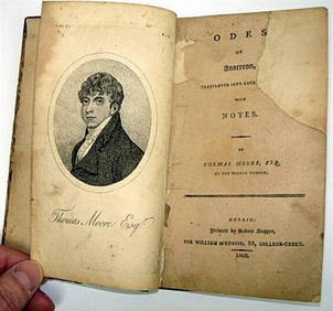
Rare 1803 Thomas Moore Odes of Anacreon 1st Edition Lodon PrintingLuis Porretta Fine Arts4.3(10)See Sold PriceMar 02, 2024
THOMAS CAMPBELL Pleasures of Hope First Edition 1st 1820 Poetry Calf BindingLuis Porretta Fine Arts4.3(10)See Sold PriceMar 02, 2024
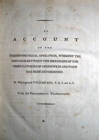
WILLIAM ROY Rare Navigation Book c1797 Trigonometry Between Paris & GreenwichLuis Porretta Fine Arts4.3(10)See Sold PriceMar 02, 2024
OFFER VAN ABRAHAM Book Of Genesis in Engravings c1700 Amsterdam Very rare!Luis Porretta Fine Arts4.3(10)See Sold PriceMar 02, 2024
MARTINET / DE VRIES Catechism of Nature 4 Vol. Set c1788 Engravings Rare!Luis Porretta Fine Arts4.3(10)See Sold PriceMar 02, 2024
Weavers Boy Poems by Chauncy Hare Townsend 1825 Calf BindingLuis Porretta Fine Arts4.3(10)See Sold PriceMar 02, 2024
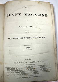
PENNY MAGAZINE 1832 & 1833 Full Bound Volumes Calf Binding THE PENNY MAGAZINELuis Porretta Fine Arts4.3(10)See Sold PriceMar 02, 2024
EARLY 18TH C. DUTCH CHART OF PACIFIC OCEAN BY FREDERIK DE WIT (1629-1706) WITH CALIFORNIA AS ANThomaston Place Auction Galleries4.4(386)See Sold PriceFeb 24, 2024
Josiah HENSCHELL c1828 Engraving Quay At Ramsgate Kent FramedLuis Porretta Fine Arts4.3(10)See Sold PriceMar 02, 2024
Joseph Martin Kronheim Pair Early Color Glamor Prints c1850Luis Porretta Fine Arts4.3(10)See Sold PriceMar 02, 2024
THOMAS KEMPIS Imitation Of Christ c1890 Superb BindingLuis Porretta Fine Arts4.3(10)See Sold PriceMar 02, 2024
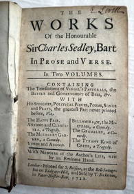
CHARLES SEDLEY BART Works In Prose c1722 1st Edition Full Calf SCARCE!Luis Porretta Fine Arts4.3(10)See Sold PriceMar 02, 2024
Lot3 Vintage Wedding Invite Engraving Plates, 1984The Benefit Shop Foundation Inc.4.3(2.9k)See Sold PriceFeb 28, 2024
Charles Cochin after Nicolas Vleughels (1668–1737), 19th century, Copper engraving, The ShieldClaydon Auctioneers Ltd4.3(125)See Sold PriceFeb 26, 2024
1816 MAP SOUTHERN PART OF RUSSIA or MUSCOVY in EUROPE copper engraving ANTIQUEJasper524.5(9.8k)See Sold PriceFeb 27, 2024
1816 MAP NORTHERN PART OF RUSSIA or MUSCOVY in EUROPE copper engraving ANTIQUEJasper524.5(9.8k)See Sold PriceFeb 27, 2024
Beaulieu, Paul-Vanier (1910-1996) Canadian, Portrait d'hommeGaia Auctions4.4(65)See Sold PriceMar 04, 2024