SoldTwo J. Janssonius Copper Engraving MapsTwo J. Janssonius original copper engravings of Thuringia and Marocchi Regnum 5 3/4" x 7 1/2" and 6 1/2" x 8"See Sold Price
SoldEarly Janssonius Copper Engraving MapsTwo J. Janssonius original copper engravings of Stiria and Taurica Cherfone 6" x 71/2" & 6" x 8"See Sold Price
SoldA 17th Century Map of Poland,J. Janssonius - Moses Pitt, c.1680, cartouche reads 'Novissima POLONIAE REGNI descriptio, copper engraving hand coloured, verso with latin text, dimensions 60.5cm x 50.5cm. Note: From the English atlaSee Sold Price
SoldA 17th Century Map of Poland, Including Coats of Arms,published c.1680, J. Janssonius – Moses Pitt, cartouche reads ‘Novissima POLONIAE REGNI description, copper engraving hand coloured, verso with Latin text, untrimmed, dimensions: printedSee Sold Price
Soldtwo copper engraving maps around 1720: Electoratustwo copper engraving maps around 1720: Electoratus Moguntinus ut et Palatin: Infer. Hassiae... Joh. Bapt. Homan, approx. 58 x 49 cm (Hesse and Palatinate) and Le Cours de la Riviere du Rhine, Sansson/See Sold Price
SoldTwo Copper Engravings Muller MapsTwo copper engravings by Muller, 1702 of Venice and Helveti 6" x 3 1/4" and 6" x 3 1/2"See Sold Price
SoldTwo J. Houbraken Copperplate EngravingsTwo J. Houbraken Copper engravings on laid paper; including; "In the Possession of John Conduit" and "In the Collection of Jr. Robert Worsely Bart"See Sold Price
SoldTwo Copper Engravings on Laid Paper by HoubrakenTwo J. Houbraken Copper engravings on laid paper; including; King Henry the IV, and Lord GeorgeSee Sold Price
SoldJ. Wilkes copper plate engraving - map of ItalyCirca 1807. map size 11"h x 8.5"w Framed 20"h x 16"w .See Sold Price
SoldTWO USGS COPPER MAP ENGRAVINGS SUMNER MISSISSIPPILot of 2 USGS topographical, hydrographical, geological, and boundary featured map engravings in copper, both measuring 17'' by 21'' weighing 13.5 pounds each. Scale of 1/31280 ; Maps 3859 encompass pSee Sold Price
Isaak Tirion, Dutch (1705-1765) Two (2) Circa 1755 HandIsaak Tirion, Dutch (1705-1765) Two (2) Circa 1755 Hand Colored Copper Engraving Maps, "Scotland" and "Europe, Africa and Asia" (2 works). Signed Within Plate. Toning Otherwise Good Condition. MeasureSee Sold Price
SoldCopper engraving map, Joh. Baptist Homann NurembergCopper engraving map, Joh. Baptist Homann Nuremberg, 18th C., Judaea and Palaestina, partly colored, two cartouches, upper with representation of Moses, who receives the Ten Commandments, smoothed creSee Sold Price
Sold4 copper engraving maps4 copper engraving maps, 18th C., 1x Rheinverlauf of F. de Wit, cartouche and borders colored, bow folds, approx. 22.5x103cm; Palatinatus Rheni of Janssonius, partially colored, approx. 38x48cm; LineSee Sold Price
SoldWorld mapWorld map 'Nova Totius Terraum Orbis Geographica Ac Hydrographica Tabula', copper engraving map of Heinrich Hondius, dated 1630,two hemispheres the world map, surrounded by rich allegorical representaSee Sold Price
SoldMazell after Donowel Perspective View of the SteyMazell after Donowel copper engraving, Perspective View of the Steyne at Brighthelmston, 1778, 10 x 16 ins. (IOB 335) and two J.Bruce coloured aquatints; Chain Pier during the tempest (319) and Kemp TSee Sold Price
SoldJ. Thomson & Co.J. Thomson & Co., A New General Atlas, Edinburgh, UK 1817 with 74 hand colored maps some with original boards, features double-page and/or folding hand-colored copper-plate engraving maps, printed bySee Sold Price
Sold1647 Antique Map of Hildesheim, GermanyCopper engraving antique map of Hildesheim, Germany entitled Episcopatus Hildesiensis Descriptio Novissima from the Toonneel des Aerdrycx, ofte nieuwe Atlas, W. & J. Blaeu, 1647-48. Good condition forSee Sold Price
18th C. Map Italy: Etats du Roy de SardaigneHand colored copper engraving atlas map on laid paper, 1787, by Clouet, J. B. L. (Jean-Baptiste Louis,) entitled "Etats du Roy de Sardaigne. (with) Isle de Sardaigne". A beautiful map, with inset, shoSee Sold Price
SoldTwo 18thC Original Copper EngravingsTwo 18thC Original Copper Engravings signed, J.J. Sukmuher Titled " Whaling in New Zealand" image size measures approx. 3.50"w x 5.75"hSee Sold Price
Sold1600s MapMap, ca 1600s, entitled: Surrey Described and Divided Into Hundreds. Copper plate engraving map printed on pulp paper, once part of a complete volume. Consists of two pages bound together as framableSee Sold Price
Mawman: Antique Map of Greece, Boeotia, 1791Map: Greece: Boeotia Date: 1791 Maker: J. Mawman Medium: Original copper engraving Size: 10 1/4" x 15 1/4" From the 1791 "Maps, Plans, Views, and Coins Illustrative of the Travels of Anacharsis the YoSee Sold Price
SoldAntique large A New Map of XVII Provinces of LowAntique large A New Map of XVII Provinces of Low Germanic. By J. Speed. Copper plate engraving. Circa 17th C. Measures 17" tall x 21" wide. Was originally purchased at Jonathan Potter., LTD, London. BSee Sold Price
Circa 1776 Celestial Map. Copper Engraving, HandCirca 1776 Celestial Map. Copper Engraving, Hand Coloured. Andromeda & Perseus. Mapmaker M. J. Fortin. Framed, Museum Glass, and Acid Free Mattes. Dimensions: 7.5" x 9.5"See Sold Price
SoldEngravings of China, 1796Heading: (China) Author: Title: Seventeen plates from the atlas to George Staunton's Embassy to China Place Published: London Publisher: Date Published: 1796-[1797] Description:See Sold Price
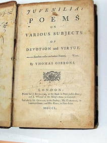
Thomas Gibbons Juvenalia 1750 Very Rare 1st Edition Full CalfLuis Porretta Fine Arts4.3(10)See Sold PriceMar 02, 2024
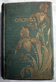
ORCHIDS Culture & Management 1st Edition c1903 ScarceLuis Porretta Fine Arts4.3(10)See Sold PriceMar 02, 2024
DAVID ROBERTS - Holy Land / Syria / Egypt etc. 3 x Folio Volumes 1849 Very RareLuis Porretta Fine Arts4.3(10)See Sold PriceMar 02, 2024
MARTINET / DE VRIES Catechism of Nature 4 Vol. Set c1788 Engravings Rare!Luis Porretta Fine Arts4.3(10)See Sold PriceMar 02, 2024
LATE 18TH C. VERY LARGE CHART OF NORTHEAST CANADA BY DES BARRES (1721-1824), 1780, FRAMEDThomaston Place Auction Galleries4.4(386)See Sold PriceFeb 24, 2024
LARGE LATE 17TH C. DUTCH CHART OF CANADA, GREAT LAKES, NEW FRANCE, LABRADOR, HUDSON BAY, BY PIERREThomaston Place Auction Galleries4.4(386)See Sold PriceFeb 24, 2024
EARLY 18TH C. DUTCH CHART OF PACIFIC OCEAN BY FREDERIK DE WIT (1629-1706) WITH CALIFORNIA AS ANThomaston Place Auction Galleries4.4(386)See Sold PriceFeb 24, 2024
RARE 1638 HONDIUS MAP OF BERMUDA, FRAMEDThomaston Place Auction Galleries4.4(386)See Sold PriceFeb 24, 2024
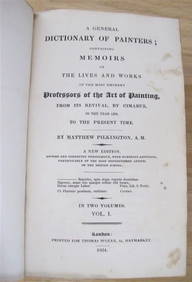
MATTHEW PILKINGTON General Dictionary Painters 2 Vol Set 1824 Calf BindingLuis Porretta Fine Arts4.3(10)See Sold PriceMar 02, 2024
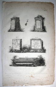
ORGIAZZI 14 x Folio Sized Engravings Roman Road Signs etc. c1802 Aix FranceLuis Porretta Fine Arts4.3(10)See Sold PriceMar 02, 2024
ALKEN / ACKERMAN Original Equestrian Aquatint Victorious Bunchclod c1847 FramedLuis Porretta Fine Arts4.3(10)See Sold PriceMar 02, 2024
A J HANDFORD British Lithographer Rome from Mount Aventi Signed c1910 FramedLuis Porretta Fine Arts4.3(10)See Sold PriceMar 02, 2024
Joseph Martin Kronheim Pair Early Color Glamor Prints c1850Luis Porretta Fine Arts4.3(10)See Sold PriceMar 02, 2024
Salvador Dali - Encounter with Two Groups of the LustyDane Fine Art Auctions4.4(494)See Sold PriceMar 07, 2024
Two (2) Antique 18th C. Copper Engraved Framed Maps - America & EuropeMagnusson Art Group4.5(46)See Sold PriceMar 14, 2024
1816 MAP SOUTHERN PART OF RUSSIA or MUSCOVY in EUROPE copper engraving ANTIQUEJasper524.5(9.8k)See Sold PriceFeb 27, 2024
1816 MAP NORTHERN PART OF RUSSIA or MUSCOVY in EUROPE copper engraving ANTIQUEJasper524.5(9.8k)See Sold PriceFeb 27, 2024
Baudelaire. Petits poemes en proses. 2 vols + suite of etchings by Grau SalaTheRedFinch Auctions4.4(24)See Sold PriceFeb 29, 2024