Sold1865 Venezuela Map1865 Venezuela map "Plano des los Estados Unidos de Venezuela, 1865". 22" x 35".See Sold Price
Sold1865 Map of New YorkLaid down. Dated 1865. Printed by H. P. Conner. Overall with frame 37" high x 22 3/4" wide. Some frame losses. IMPORTANT: Before bidding, please read the terms and conditions below. When you registereSee Sold Price
SoldVirgin Islands to Margarita Island, Venezuela Map, 1680Isles d'Amerique dites Caribes et Antilles et de Barlovento. A beautifully colored exemplar of Du Val's uncommon map of the Lesser Antilles from the Virgin Islands to Margarita Island off the coast ofSee Sold Price
SoldJ. H. Colton 1865 Map of Massachusetts and RhodeHand-colored lithograph on paper. 13.5 by 16.5 inches, sight. Bird's eye maple frame, 21.5 by 24.5 inches.See Sold Price
SoldSAMUEL LEWIS (C. 1782 TO 1865) MAP OF VIRGINIASAMUEL LEWIS (C. 1782 TO 1865) MAP OF VIRGINIA, on laid paper, title in octagonal cartouche to upper left corner "VIRGINIA", above "S. Lewis, del." and scale, lettered "Tanner, Sc." to lower right corSee Sold Price
SoldRARE CIVIL WAR 1865 MAP OF BURNT RICHMOND, VA. THATApril 1865 "Map of a Part of the City of Richmond, showing the Burnt Districts", Published by Wm. Ira Smith, , proprietor Richmond Whig, drawn on stone by C.L. Ludwig. On blue paper, unframed, 11" x 1See Sold Price
Sold1865 Map of ChinaAuthor: Johnson Title: 1865 Map of China Medium: Ink on Paper Dimensions: 17.5"X13.5" Map of China dated 1864. Engraved by A.J.Johnson. Published by Johnson and Ward in New York. Map key located upperSee Sold Price
SoldUniversal - Universal Genève with Venezuela map,Stainless steel round caseDial in polychrome enamel depicting the map of Venezuela, applied arabic numerals and indexesHand-winding movementLeather strap Size: 35 mm See Sold Price
Sold1865 Map of Upper and Lower Canada, Hand-Colored1865 Map of upper and lower Canada, hand-colored, 26 1/2" x 18" unframed. Good condition.See Sold Price
1865 Map of New York Canals and Feeders"Profiles of the New York State Canals and Feeders". Showing the Erie Canal from Lake Erie to the Hudson River. Information insets for the Erie Canal and 9 different feeder canals. Lower right "Map ofSee Sold Price
Progress of Emancipation 1850- 1865 mapUnknown. Progress of Emancipation. 1850 -1865. Progress of Emancipation 1850 - 1865. Framed. Medium: Print. Size: 6.5" X 8.5". Signature: Unsigned.See Sold Price
Sold1865 VENEZUELA #20a ARMS 1r BISECT ON PIECE(SCV$500) Bisect tied to light blue piece by numeral '3' cancel. Fine to very fine. Scott CV for on cover. Regency Code: 351903See Sold Price
Johnson's Sweden, Norway & Denmark with Sleswick & Holstein. Schleswig 1865 mapTITLE/CONTENT OF MAP: 'Johnson's Sweden and Norway - Johnson's Denmark with Sleswick & Holstein' DATE PRINTED: 1865 IMAGE SIZE: Approx 42.0 x 57.0cm, 16.5 x 22.5 inches (Large); Please note that thisSee Sold Price
1865 Map New York Canals & Railroads"Profiles of the New York State Canals and Feeders Showing the Elevations of the Same above Tide Water and the Junction of the Lateral Canals with the Erie . Wm. B. Taylor State Engr. & Survr. R.H. ShSee Sold Price
Authentic Vintage 1928 - Venezuela MapAuthentic Vintage 1928 - Venezuela Map **|**|** This is a beautiful, 87 year old map of Venezuela. The details are crisp and the aged color has a perfect antique feel. The map is large - measuring appSee Sold Price
Johnson's Asia. Bod or Tibet. Toorkistan Cabool Birmah Persia Corea 1865 mapTITLE/CONTENT OF MAP: 'Johnson's Asia' DATE PRINTED: 1865 IMAGE SIZE: Approx 34.0 x 41.5cm, 13.25 x 16.25 inches (Large); Please note that this is a folding map. TYPE: Large, decorative hand colouredSee Sold Price
World. Animals Birds Industries Ocean Currents Watersheds. JOHNSON 1865 mapTITLE/CONTENT OF MAP: 'Johnson's Map of The World Showing the Geographical Distribution & Range of The Principal Members of The Animal Kingdom (with) Bird Map. Johnson's Map of The World IllustratingSee Sold Price
World Meteorology. Land features. Co-tidal Lines. Agriculture. JOHNSON 1865 mapTITLE/CONTENT OF MAP: 'Johnson's Map Illustrating the Principal Features of Meteorology (with) Rain Map. Johnson's Map Illustrating the Principal Features of the Land and the Co-tidal Lines. Johnson'sSee Sold Price
Johnson's Sweden, Norway & Denmark with Sleswick & Holstein. Schleswig 1865 mapTITLE/CONTENT OF MAP: 'Johnson's Sweden and Norway - Johnson's Denmark with Sleswick & Holstein' DATE PRINTED: 1865 IMAGE SIZE: Approx 42.0 x 57.0cm, 16.5 x 22.5 inches (Large); Please note that thisSee Sold Price
Johnson's Asia. Bod or Tibet. Toorkistan Cabool Birmah Persia Corea 1865 mapTITLE/CONTENT OF MAP: 'Johnson's Asia' DATE PRINTED: 1865 IMAGE SIZE: Approx 34.0 x 41.5cm, 13.25 x 16.25 inches (Large); Please note that this is a folding map. TYPE: Large, decorative hand colouredSee Sold Price
SoldJohnson & Ward: Antique Map of Texas, 1865JohnsonÂ’s New Map of the State of Texas, Johnson & Ward, 1865. This is an exceptionally clean example of Johnson and Ward's highly desirable 1865 map of Texas. Because of the high acidity in the pSee Sold Price
SoldJohnson’s Map of Oregon & Washington, 1865Original steel engraving by A. J. Johnson, New York, 1865. Map features railroads, wagon toads, Indian tribes, springs and fords, as well as the usual geographical and political features. Dimensions:See Sold Price
SoldANTIQUE GOLD CHARM BRACELET 12 CHARMS, 31.2 GRAMS 8K,THIS IS AN ANTIQUE BRACELET WITH 12 CHARMS THAT WERE PROBABLY COLLECTED DURING VARIOUS TRAVELS. MOST OF THE CHARMS ARE MARKED AND TESTED 14K. THE "VENEZUELA" MAP CHARM IS 18K. ONLY THE CLOCK AND THE BSee Sold Price
SoldJohnson's Map of Montana & Surrounding States 1865This is a hand colored original 1865 map titled, "Johnson's Nebraska, Dakota, Idaho, Montana and Wyoming. Published by A.J. Johnson, New York." The bottom right of the map is marked, "Entered accordinSee Sold Price
Central Railroad of New Jersey Map of Sandy Hook Route-ca. 1903JM Hobby Supply and Railroad Artifact Auctions4.4(126)See Sold PriceFeb 24, 2024
Rand McNally/Santa Fe Railroad Map of Iowa-1912JM Hobby Supply and Railroad Artifact Auctions4.4(126)See Sold PriceFeb 24, 2024
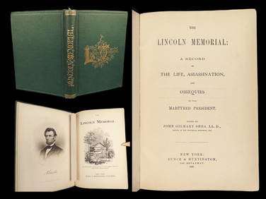
1865 Abraham LINCOLN 1ed MEMORIAL Life and Assassination US President BiographySchilb Antiquarian Rare Books4.8(421)See Sold PriceMar 10, 2024
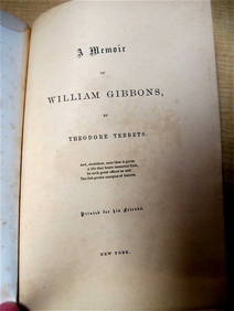
WILLIAM GIBBONS by Tebbets 1865 1st Ed. Rare Quaker Interest Signed by Author New YorkLuis Porretta Fine Arts4.3(10)See Sold PriceMar 02, 2024
17TH C. WORLD MAP BY NICOLAES VISSCHER (NETHERLANDS, 1618-1709)Thomaston Place Auction Galleries4.4(386)See Sold PriceFeb 24, 2024
LATE 17TH C. FRENCH MAP OF THE NEW WORLD BY ALEXIS-HUBERT JAILLOT (1632-1712)Thomaston Place Auction Galleries4.4(386)See Sold PriceFeb 24, 2024
18TH C. ANTIQUE MAP: FRENCH & INDIAN WAR, FRAMEDThomaston Place Auction Galleries4.4(386)See Sold PriceFeb 24, 2024
NICOLAES VISSCHER (NETHERLANDS, 1618-1709) MAP OF THE NEW WORLDThomaston Place Auction Galleries4.4(386)See Sold PriceFeb 24, 2024
Keith Haring - Ink on New York Map, Best Buddies, Inscribed, Signed, and DatedSapphire Auction Gallery4(67)See Sold PriceMar 02, 2024
Rand McNally Railroad Map Cabinet w/ 21 Railroad MapsRail & Road Auctions4.6(165)See Sold PriceMar 08, 2024
[CHICAGO]. Rare Pre-Fire Illinois Map: “Blanchard’s Map of ...Potter & Potter Auctions4.6(539)See Sold PriceMar 07, 2024
[MAPS]. DUFOUR, Auguste-Henri (1795-1865). Bound Volume of ...Potter & Potter Auctions4.6(539)See Sold PriceMar 07, 2024
Putnam - First Map of the State of Ohio by Rufus PutnamTrillium Antique Prints & Rare Books4.5(30)See Sold PriceFeb 24, 2024
Mexico, Central America and West Indies Physical PoliticalJasper524.5(9.8k)See Sold PriceFeb 27, 2024


![[CHICAGO]. Rare Pre-Fire Illinois Map: “Blanchard’s Map of ... (1 of 2)](https://p1.liveauctioneers.com/928/318880/171361260_1_x.jpg?height=282&quality=70&version=1707501302)
![[MAPS]. DUFOUR, Auguste-Henri (1795-1865). Bound Volume of ... (1 of 2)](https://p1.liveauctioneers.com/928/318880/171361279_1_x.jpg?height=282&quality=70&version=1707501302)